 W
WThe Ouachita National Forest is a National Forest that lies in the western portion of Arkansas and portions of eastern Oklahoma.
 W
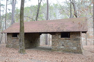
WThe Bard Springs Bathhouse is a historic recreational support facility in Ouachita National Forest. It is located at the Bard Springs recreation site, southeast of Mena and north of Athens in Polk County, off County Road 82 and Forest Road 106 on the banks of Blaylock Creek. It is a single story rustic stone structure, with entrances at either end into open areas for changing. The interior is lit by skylights in the roof. It was built in 1936 by a crew of the Civilian Conservation Corps, and is one of four surviving CCC structures in the immediate area.
 W
WThe Bard Springs Dam No. 1 is a historic recreational support facility in Ouachita National Forest. It is located at the Bard Springs recreation site, southeast of Mena and north of Athens in Polk County, off County Road 82 and Forest Road 106 on the banks of Blaylock Creek. This dam is located at the western end of the recreation area, and is about 65 feet (20 m) long and 8 feet (2.4 m) high at its center. It is made of fieldstone, and has a series of chutes and steps across its top. It was built in 1936 by a crew of the Civilian Conservation Corps, and is one of four surviving CCC structures in the immediate area.
 W
WThe Bard Springs Dam No. 2 is a historic recreational support facility in Ouachita National Forest. It is located at the Bard Springs recreation site, southeast of Mena and north of Athens in Polk County, off County Road 82 and Forest Road 106 on the banks of Blaylock Creek. This dam is located at the eastern end of the recreation area, and is about 75 feet (23 m) long and 15 feet (4.6 m) high at its center. It is made of fieldstone, and has a series of staggered steps at its base to reduce erosion. It was built in 1936 by a crew of the Civilian Conservation Corps, and is one of four surviving CCC structures in the immediate area.
 W
WThe Bard Springs Picnic Shelter is a historic recreational support facility in Ouachita National Forest. It is located at the Bard Springs recreation site, southeast of Mena and north of Athens in Polk County, off County Road 82 and Forest Road 106 on the banks of Blaylock Creek. It is a square open-air structure, with four rustic stone columns supporting a gabled roof. The foundation is stone, with the support columns set in concrete blocks. It was built in 1936 by a crew of the Civilian Conservation Corps, and is one of four surviving CCC structures in the immediate area.
 W
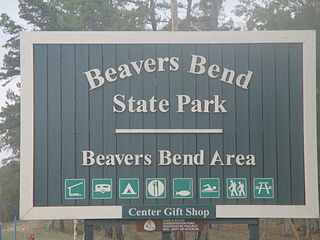
WBeavers Bend State Park is a 1,300 acres (5.3 km2) Oklahoma state park located in McCurtain County. It is approximately 10.5 miles (16.9 km) north of Broken Bow on SH-259A. It was established in 1937 and contains Broken Bow Lake.
 W
WBeech Creek National Scenic Area is a federally designated National Scenic Area within Ouachita National Forest near It is 6 miles (9.7 km) east and 5 miles (8.0 km)south of the unincorporated community of Big Cedar in Le Flore County, Oklahoma, USA. The 7,500-acre (30 km2) scenic area is administered by the U.S. Forest Service, a part of the U.S. Department of Agriculture. The scenic area includes 32 miles (51 km) of hiking trails, some on former roads. The original designated area, the Beech Creek Botanical Area, remains, conserving mature beech trees near the headwaters of Beech Creek.
WBlack Fork Mountain Wilderness is located in the U.S. states of Arkansas and Oklahoma. Created by an act of Congress in 1984, the wilderness covers an area of 13,139 acres (53 km²). The Arkansas portion contains 8,430 acres (34.1 km2) and the Oklahoma portion contains 5,140 acres (20.8 km2). Located within Ouachita National Forest, the wilderness is managed by the U.S. Forest Service. The area is about 2 miles (3.2 km) north of Page, Oklahoma, and about 6 miles (9.7 km) north of Mena, Arkansas.
 W
WBroken Bow Lake is a reservoir in southeastern Oklahoma, located on Mountain Fork River and 9 miles (14 km) northeast of the town of Broken Bow in McCurtain County. It is one of the largest fresh water lakes within the state of Oklahoma, and a popular tourist destination for locals and visitors from neighboring Texas and Arkansas.
 W
WThe Buckeye Vista Overlook is a historic scenic overlook in Ouachita National Forest. It is located on Ouachita National Forest Road 38 on the north side of Buckeye Mountain. The overlook is a simple roadside pullout on the north side of the road, with a retaining wall about 70 feet (21 m) long. The wall was built out of quarried stone and mortar in 1935 by a crew of the Civilian Conservation Corps (CCC). It is one of only two CCC-built overlooks in the national forest.
 W
WCamp Clearfork is a group use recreational facility in Ouachita National Forest, west of the city of Hot Springs, Arkansas. It is located at the end of Camp Clearfork Trail, south of United States Route 270. The camp was developed in the 1930s by the Civilian Conservation Corps (CCC), and includes cabins, a recreation hall, and Camp Clearfork Reservoir, impounded by a CCC-built dam.
 W
WThe Camp Ouachita Girl Scout Camp Historic District encompasses a campground area built by crews of the Civilian Conservation Corps in the 1930s on the northern shore of Lake Sylvia, a man-made lake in the eastern part of Ouachita National Forest. The center of the campground, including its Great Hall and administration buildings, is located at the northern tip of Lake Sylvia, with cabins, comfort facilities, and other infrastructure arrayed around the northern and western sides of the lake. It was the first Girl Scout camp in the state, and is a well-preserved example of the Rustic style of architecture for which the CCC is known.
WThe Caney Creek Wilderness is a rugged 14,460 acres (5,850 ha) segment of the Ouachita National Forest in the U.S. state of Arkansas. Visitors can enjoy the area in a number of ways such as hiking and. Short Creek and Caney Creek are surrounded by bottomland forest and separated by steep ridges, with the Cossatot River on the west side.
WThe CCC Company 741 Powder Magazine Historic District encompasses two structures built by Camp 741 of the Civilian Conservation Corps c. 1936. The camp, the first established in Arkansas, used these structures to store explosive materials used in road and bridge construction projects. The two structures have concrete bases and tops, and have walls of cut fieldstone and concrete. The main magazine is 8 by 16 feet, and the blasting cap storage building is about 10 by 10 feet. The main magazine is located a short way north of Forest Road 177M in Ouachita National Forest; the blasting cap storage building is about 113 metres (371 ft) to its northwest.
WThe CCC Company 947 Powder Magazine is a historic powder magazine in the eastern part of Ouachita National Forest. It is located in southern Yell County, about 200 yards (180 m) down a slope north of a ridge running parallel to Forest Road 71. The structure is made of stone and concrete, and is 6 feet (1.8 m) square and 5 feet (1.5 m) high, with a flat concrete roof and floor. The entrance is on the southeast side. The building was erected about 1933 by a crew of the Civilian Conservation Corps, and was used to store explosive materials used in the construction of roads and bridges in the area.
 W
WThe Charlton Recreation Area is a public use area of the Ouachita National Forest, located just north of United States Route 270 between Crystal Springs and Mount Ida, Arkansas. The area includes a campground and day use facilities for water-related activities on Walnut Creek, including fishing and swimming. The facilities are organized around a small artificial lake created in 1938 by a crew of the Civilian Conservation Corps by damming the creek. The stone Charlton Dam and Spillway, about 100 feet (30 m) in length, was listed on the National Register of Historic Places 1993, as was the stone Charlton Bathhouse, also built by the CCC in 1938.
 W
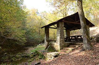
WThe Collier Springs Picnic Area is located on Forest Road 177 in Ouachita National Forest, northeast of Norman, Arkansas. The picnic area is notable for the presence of the Collier Springs Shelter, which was built by crews of the Civilian Conservation Corps in 1939. It is a rectangular open-air stone structure, with stone columns topped by hewn log beams that support the gabled roof. The shelter also acts as a protective cover for the eponymous spring, which is fed via a pipe to the nearby creek. Facilities at the picnic area also include a vault toilet.
 W
WCrossett Experimental Forest is an experimental forest operated by the Southern Research Station (SRS) of the United States Forest Service in Ashley County, Arkansas. It is managed out of the SRS office in Monticello, Arkansas, with onsite facilities about 6.8 miles (10.9 km) south of Crossett, Arkansas off Arkansas Highway 133.
 W
WThe Crystal Campground is located on Forest Road 177 in Ouachita National Forest, northeast of Norman, Arkansas. The campground has nine campsites and a picnic shelter, and provides access to outdoor recreational activities including hiking, swimming, and fishing. The swimming area is made possible by the Crystal Springs Dam, a 30-foot (9.1 m) fieldstone dam built in 1935 by the Civilian Conservation Corps, that impounds Montgomery Creek to provide a swimming hole. The campground's main picnic shelter was also built by the CCC at that time. Both the dam and the shelter were listed on the National Register of Historic Places in 1993.
 W
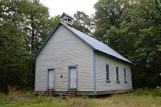
WThe Hawks Schoolhouse is a historic school building in rural western Perry County, Arkansas. It is located on the south side of County Road 7, in the easternmost section of Ouachita National Forest, near the hamlet of Ava. It is a single-story wood frame structure, with a gabled roof and weatherboard siding. The roof is capped by a small gable-roofed open belfry. The front facade has a pair of symmetrically placed entrances with simple molding. It was built in 1911, and is a well-preserved example of a district schoolhouse in a rural context.
 W
WThe Hollis Country Store is a historic general store on Arkansas Highway 7 in rural Perry County, Arkansas. It is located on the west side of AR 7 in the Ouachita National Forest, a short way north of the South Fourche LaFave River Bridge. In addition to the store, the property includes a picnic shelter and two tourist cabins. The core of the store is a stone structure built in 1931–32, with most of the other parts added in the 1950s. It is an excellent example of vernacular roadside architecture from the period.
WIndian Nations National Scenic and Wildlife Area is a federally designated National Scenic Area within Ouachita National Forest 11 miles (18 km) south of Heavener, in Le Flore County, Oklahoma USA. The 41,051-acre (16,613 ha) scenic area is administered by the U.S. Forest Service. The scenic area includes the Homer L. Johnson Wildlife Management Area. There is also a 15-acre (6.1 ha) fishing lake atop Post Mountain,developed by the U. S. Forest Service during the 1930s, is included within the scenic area.
 W
WThe Iron Springs Recreation Area is a roadside picnic area on Arkansas Highway 7, north of Jessieville in the Ouachita National Forest. The area has three shelters for picnicking, vault toilets, and an accessible trail for viewing the springs in the area. The facilities were largely built by the Civilian Conservation Corps (CCC) in the 1930s, with two shelters and the nearby dam listed on the National Register of Historic Places.
 W
WThe Jack Creek Bathhouse is a historic recreational facility in Ouachita National Forest, Logan County, Arkansas. It is located south of Booneville, at the Jack Creek Recreation Area in the northern part of the national forest. It is a single-story masonry structure, built out of rustic stone, with a gabled roof supported by logs. It has two dressing rooms, separated by an open breezeway. It was built in 1936 by a crew of the Civilian Conservation Corps, and is a well-preserved example of the Rustic architecture the CCC is well known for producing.
 W
WLake Wister is a reservoir in Le Flore County, in southeast Oklahoma. The lake is created by the Poteau River and the Fourche Maline creek. Wister Lake was authorized for flood control and conservation by the Flood Control Act of 1938. The project was designed and built by the Tulsa District Corps of Engineers. Construction began in April 1946, and the project was placed in full flood control operation in December 1949.
 W
WThe Ouachita Mountains, simply referred to as the Ouachitas, are a mountain range in western Arkansas and southeastern Oklahoma. They are formed by a thick succession of highly deformed Paleozoic strata constituting the Ouachita Fold and Thrust Belt, one of the important orogenic belts of North America. The Ouachitas continue in the subsurface to the northeast where they make a poorly understood connection with the Appalachians and to the southwest where they join with the Marathon uplift area of West Texas. Together with the Ozark Plateaus, the Ouachitas form the U.S. Interior Highlands. The highest natural point is Mount Magazine at 2,753 feet.
WOuachita National Recreation Trail is a 223-mile (359 km) long, continuous hiking trail through the Ouachita Mountains of Oklahoma and Arkansas. It is the longest backpacking trail in the Ouachita National Forest, spanning 192 miles across its length. Approximately 177 miles of the trail is in Arkansas and 46 miles of the trail is in Oklahoma. The trail is used by hikers, backpackers, hunters, and mountain bikers. It is a non-motorized single track trail open only to foot traffic and partially open to mountain bicycles. Segments opened to mountain bikes are from the western terminus of the Ouachita Trail at Talimena State Park to the Big Cedar trailhead on US Highway 259 at approximately Mile Marker (MM) 30.5 in Oklahoma, and from the Talimena Scenic Drive Trailhead at MM 54.1, east to Highway 7 at mile 160.4, north of Jessieville, Arkansas.
 W
WThe Poteau Work Center is a utility building located at the Poteau District Headquarters of the Ouachita National Forest in Waldron, Arkansas. It is a rectangular single-story wood-frame building with gable roof, and is distinguished by centrally-located garage doors on each of its long sides. The building was, constructed about 1939 by a work crew of the Civilian Conservation Corps.
 W
WThe Poteau Work Center Residence No. 2 is a historic house at the Poteau District Headquarters of the Ouachita National Forest in Waldron, Arkansas. It is a single-story wood-frame house, with a shallow-sloped gable roof and novelty siding. Its central entry is sheltered by a porch supported by trios of columns. The building was built c. 1939 by a crew of the Civilian Conservation Corps.
WThe Powder Magazine is a surviving structure of the Civilian Conservation Corps (CCC) camp of the 1707th Company. Located in Ouachita National Forest in the northeast corner of Scott County, Arkansas, it is a small stone and concrete structure about 4 by 3 feet and between 3 and 4-1/2 feet in height. It is located about 50 yards (46 m) south of the T-shaped junction of two forest roads in 1993) on top of a ridge above Dutch Creek. The structure was built to house the camp's explosives, which were typically used by the camp crew for road and bridge building projects.
 W
WShady Lake Recreation Area is a campground and public recreation area in southwestern Ouachita National Forest, southwest of Mena, Arkansas and west of Glenwood, Arkansas. The area is oriented around Shady Lake, a body of water on the South Fork Saline River impounded by a dam built c. 1940 by the Civilian Conservation Corps (CCC). The area is administered by the United States Forest Service (USFS).
 W
WThe Sugar Creek Vista Overlook is a historic scenic overlook in Ouachita National Forest. It is located on Polk County Road 64, just south of Dicks Gap. The overlook is a simple roadside pullout on the west side of the road, with an angular retaining wall about 84 feet (26 m) long. The wall was built out of quarried novaculite stone set with grapevine mortar joints in 1935 by a crew of the Civilian Conservation Corps (CCC). It is one of only two CCC-built overlooks in the national forest, and the only one built with these particular materials.
 W
WThe Talimena Scenic Drive is a National Scenic Byway in southeastern Oklahoma and extreme western Arkansas spanning a 54.0-mile (86.9 km) stretch of Oklahoma State Highway 1 (SH-1) and Arkansas Highway 88 (AR 88) from Talihina, Oklahoma, to Mena, Arkansas.
WThe Tall Peak Fire Tower is a historic fire tower in Ouachita National Forest. It is located at the top of Tall Peak in the southwestern part of the national forest in Polk County, Arkansas. It is a fieldstone structure, built about 1938 by a crew of the Civilian Conservation Corps (CCC), and features the distinctive flared corners that typify CCC architecture. It is accessible via a forest service road off Polk County 64.
WThe Upper Kiamichi River Wilderness is located in the U.S. state of Oklahoma. Created by an act of Congress in 1988, the wilderness covers an area of 9,754 acres (39.47 km2). Contained within Ouachita National Forest, the wilderness is managed by the U.S. Forest Service.
WWinding Stair Mountain National Recreation Area is a United States National Recreation Area located within the Ouachita National Forest. State Highway 1, known as the Talimena Scenic Byway in this area, bisects the recreation area. U. S. Highway 271 loops up through the summit. Winding Stair Mountain National Recreation Area and the nearby Upper Kiamichi River and Black Fork Mountain Wilderness areas were created by an act of Congress on October 18, 1988.
 W
WThe Womble District Administration House No. 1 is a historic house in the Ouachita National Forest. It is located on the north side of United States Route 270, east of Mount Ida and just west of the highway's crossing of Williams Stream. It is a 1 1⁄2-story wood-frame structure, with a side-gable roof, novelty siding, and stone foundation. Its main facade, facing south, has a projecting gable-roofed porch, whose gable is finished in vertical board-and-batten siding. It was built about 1940 by a crew of the Civilian Conservation Corps as the administrative headquarters of the Womble District of the national forest.