 W
WThe following table is a partial list of artificial objects on the surface of Mars, consisting of spacecraft which were launched from Earth. Most are defunct after having served their purpose, but the Curiosity rover and the InSight lander are still operational as of 2019. InSight is the most recent artificial object to land safely on Mars. The table does not include smaller objects, such as springs, fragments, parachutes and heat shields. As of November 5, 2016, there are about 14 spacecraft missions on the surface of Mars: some of these missions have multiple spacecraft.
 W
WAvernus Colles is a region of fractured terrain on Mars on the southeast margin of Elysium Planitia, at 1.6°S, 171°E. It is fairly large, being 244 km (152 mi) in diameter. Avernus Colles can be found in the Elysium quadrangle. It was named in 1985 after a lake in Campania, Italy, which is believed by some to be an entrance to the underworld.
 W
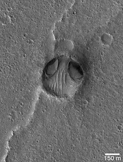
WBrain terrain, also called knobs-brain coral and brain coral terrain, is a feature of the Martian surface, consisting of complex ridges found on lobate debris aprons, lineated valley fill and concentric crater fill. It is so named because it suggests the ridges on the surface of the human brain. Wide ridges are called closed-cell brain terrain, and the less common narrow ridges are called open-cell brain terrain. It is thought that the wide closed-cell terrain contains a core of ice, and when the ice disappears the center of the wide ridge collapses to produce the narrow ridges of the open-cell brain terrain. Shadow measurements from HiRISE indicate the ridges are 4-5 meters high. Brain terrain has been observed to form from what has been called an "Upper Plains Unit." The process begins with the formation of stress cracks. The upper plains unit fell from the sky as snow and as ice coated dust.
 W
WCape Verde is a large promontory and extremity on the rim of Victoria Crater in Meridiani Planum, an extraterrestrial plain within the Margaritifer Sinus quadrangle (MC-19) region of the planet Mars. The Mars Exploration Rover Opportunity perched atop this feature in 2006 to take a true-color mosaic of the crater below. Sols 958 to 991 were spent on this cape, including the period of solar conjunction which spanned from sol 970 to sol 984.
 W
WCape York is a location on Mars, on the western rim of Endeavour crater. The Opportunity rover spent about two years exploring this portion of the rim in the early 2010s before moving south. The CRISM instrument on the orbiting Mars Reconnaissance Orbiter identified clay smectites in an area of Cape York, and the rover was sent to explore this location. MER-B Opportunity spend its fifth Martian Winter at Greeley Haven at Cape York, and also took a panorama at that location. MER-B spent 19 weeks stationed at Greeley Haven surviving the winter and went on the move again in May 2012, to further explore Cape York.
 W
WThe Chryse Alien refers to a Martian crater in the Chryse Planitia, with a perceived resemblance to an "alien head".
 W
WDark slope streaks are narrow, avalanche-like features common on dust-covered slopes in the equatorial regions of Mars. They form in relatively steep terrain, such as along escarpments and crater walls. Although first recognized in Viking Orbiter images from the late 1970s, dark slope streaks were not studied in detail until higher-resolution images from the Mars Global Surveyor (MGS) and Mars Reconnaissance Orbiter (MRO) spacecraft became available in the late 1990s and 2000s.
 W
WMany areas on Mars experience the passage of giant dust devils. These dust devils leave tracks on the surface of Mars because they disturb a thin coating of fine bright dust that covers most of the Martian surface. When a dust devil goes by it blows away the coating and exposes the underlying dark surface. Within a few weeks, the dark track assumes its former bright colour, either by being re-covered through wind action or due to surface oxidation through exposure to sunlight and the Martian atmosphere.
 W
WEden Patera is a feature located in the Mare Acidalium quadrangle on the planet Mars. In October 2013 the feature gained some attention when it was speculated it may be a supervolcano rather than an impact crater, according to research from the Planetary Science Institute in Tucson, led by Joseph R. Michalski. The research postulated the crater was formed by the volcano's caldera collapsing, rather than from an impact. Some of reasons for suspecting that Eden Patera is a collapsed caldera not an impact crater are its irregular shape, an apparent lack of a raised rim or central peak, and lack of impact ejecta.
 W
WElysium, located in the Elysium and Cebrenia quadrangles, is the second largest volcanic region on Mars, after Tharsis. The region includes the volcanoes Hecates Tholus, Elysium Mons and Albor Tholus. The province is centered roughly on Elysium Mons at 24.7°N 150°E. Elysium Planitia is a broad plain to the south of Elysium, centered at 3.0°N 154.7°E. Another large volcano, Apollinaris Mons, lies south of Elysium Planitia and is not part of the province. Besides having large volcanoes, Elysium has several areas with long trenches, called fossa or fossae (plural) on Mars. They include the Cerberus Fossae, Elysium Fossae, Galaxias Fossae, Hephaestus Fossae, Hyblaeus Fossae, Stygis Fossae and Zephyrus Fossae.
 W
WEridania Lake is a theorized ancient lake on Mars with a surface area of roughly 1.1 million square kilometers. It is located at the source of the Ma'adim Vallis outflow channel and extends into Eridania quadrangle and the Phaethontis quadrangle. As Eridania Lake dried out in the late Noachian epoch it divided into a series of smaller lakes.
 W
WMartian geysers are putative sites of small gas and dust eruptions that occur in the south polar region of Mars during the spring thaw. "Dark dune spots" and "spiders" – or araneiforms – are the two most visible types of features ascribed to these eruptions.
 W
WGlaciers, loosely defined as patches of currently or recently flowing ice, are thought to be present across large but restricted areas of the modern Martian surface, and are inferred to have been more widely distributed at times in the past. Lobate convex features on the surface known as viscous flow features and lobate debris aprons, which show the characteristics of non-Newtonian flow, are now almost unanimously regarded as true glaciers.
 W
WInverted relief, inverted topography, or topographic inversion refers to landscape features that have reversed their elevation relative to other features. It most often occurs when low areas of a landscape become filled with lava or sediment that hardens into material that is more resistant to erosion than the material that surrounds it. Differential erosion then removes the less resistant surrounding material, leaving behind the younger resistant material, which may then appear as a ridge where previously there was a valley. Terms such as "inverted valley" or "inverted channel" are used to describe such features. Inverted relief has been observed on the surfaces of other planets as well as on Earth. For example, well-documented inverted topographies have been discovered on Mars.
 W
WLineated valley fill (LVF), also called lineated floor deposit, is a feature of the floors of some channels on Mars, exhibiting ridges and grooves that seem to flow around obstacles. Shadow measurements show that at least some of the ridges are several metres high. LVF is believed to be ice-rich. Hundreds of metres of ice probably lie protected in LVF under a thin layer of debris. The debris consists of wind-borne dust, material from alcove walls, and lag material remaining after ice sublimated from a rock-ice mixture. Some glaciers on Earth show similar ridges. High-resolution pictures taken with HiRISE reveal that some of the surfaces of lineated valley fill are covered with strange patterns called closed-cell and open-cell brain terrain. The terrain resembles a human brain. It is believed to be caused by cracks in the surface accumulating dust and other debris, together with ice sublimating from some of the surfaces. The cracks are the result stress from gravity and seasonal heating and cooling. This same type of surface is present on Lobate debris aprons and Concentric crater fill so all three are believed to be related.
 W
WLink is a rock outcrop on the surface of Aeolis Palus, between Peace Vallis and Aeolis Mons, in Gale crater on the planet Mars. The outcrop was encountered by the Curiosity rover on the way from Bradbury Landing to Glenelg Intrigue on September 2, 2012, and was named after a significant rock formation in the Northwest Territories of Canada. The "approximate" site coordinates are: 4.59°S 137.44°E.
 W
WThis is a list of areas of chaos terrain officially named by the International Astronomical Union on the planet Mars. Chaos terrain is an astrogeological term used to denote planetary surface areas where features such as ridges, cracks, and plains appear jumbled and enmeshed with one another. Coordinates are in planetocentric latitude with east longitude.
 W
WThis is a list of dune fields not on Earth which have been given official names by the International Astronomical Union. Dune fields are named according to the IAU's rules of planetary nomenclature. The relevant descriptor term is undae. As of now, the only two Solar System planets, besides Earth, with named dune fields are Venus and Mars. Dune fields have also been discovered on Saturn's moon Titan, Pluto and comet 67P/Churyumov–Gerasimenko.
 W
WLobate debris aprons (LDAs) are geological features on Mars, first seen by the Viking Orbiters, consisting of piles of rock debris below cliffs. These features have a convex topography and a gentle slope from cliffs or escarpments, which suggest flow away from the steep source cliff. In addition, lobate debris aprons can show surface lineations as do rock glaciers on the Earth.
 W
WThe surface of the planet Mars appears reddish from a distance because of rusty dust suspended in the atmosphere. From close up, it looks more of a butterscotch, and other common surface colors include golden, brown, tan, and greenish, depending on minerals.
 W
WMartian regolith simulant is a terrestrial material that is used to simulate the chemical and mechanical properties of Martian regolith for research, experiments and prototype testing of activities related to Martian regolith such as dust mitigation of transportation equipment, advanced life support systems and in-situ resource utilization.
 W
WMartian soil is the fine regolith found on the surface of Mars. Its properties can differ significantly from those of terrestrial soil, including its toxicity due to the presence of perchlorates. The term Martian soil typically refers to the finer fraction of regolith. So far, no samples have been returned to Earth, the goal of a Mars sample-return mission, but the soil has been studied remotely with the use of Mars rovers and Mars orbiters.
 W
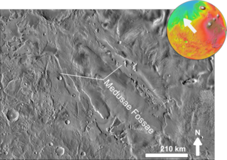
WThe Medusae Fossae Formation is a large geological unit of probable volcanic origin on the planet Mars. It is named for the Medusa of Greek mythology. "Fossae" is Latin for "trenches". Located roughly at 5°S 213°E, it straddles the highland - lowland boundary near the Tharsis and Elysium volcanic areas. The Medusae Fossae Formation lies partly in five quadrangles: the Amazonis quadrangle, the Tharsis quadrangle, the Memnonia quadrangle, the Elysium quadrangle, and the Aeolis quadrangle.
 W
WNilo Syrtis is a region just north of Syrtis Major Planum on Mars, at approximately 23°N, 76°E and an elevation of −0.5 km. It marks a region of transition between southern highland and northern lowland terrain, and consists of isolated peaks and mesas. On average, the drop in elevation between the two terrains is 5,500 meters.
 W
WThe North Polar Basin, more commonly known as the Borealis Basin, is a large basin in the northern hemisphere of Mars that covers 40% of the planet. Some scientists have postulated that the basin formed during the impact of a single, large body roughly 2% the mass of Mars, having a diameter of about 1,900 km. However, the basin is not currently recognized as an impact basin by the IAU. The basin is one of the flattest areas in the Solar System, and has an elliptical shape. Chryse Planitia, the landing site of the Viking 1 lander, is a bay that opens into this basin.
 W
WOrcus Patera is a region on the surface of the planet Mars first photographed by Mariner 4. Of unknown formation, whether by volcanic, tectonic, or cratering causes, the region includes a depression about 380 kilometres long, 140 kilometres wide, surrounded by a rim up to 1.8 kilometres high.
 W
WOutflow channels are extremely long, wide swathes of scoured ground on Mars, They extend many hundreds of kilometers in length and are typically greater than one kilometer in width. They are thought to have been carved by huge outburst floods.
 W
WA Ring mold crater is a kind of crater on the planet Mars that looks like the ring molds used in baking. They are believed to be caused by an impact into ice. The ice is covered by a layer of debris. They are found in parts of Mars that have buried ice. Laboratory experiments confirm that impacts into ice result in a "ring mold shape." They are also bigger than other craters in which an asteroid impacted solid rock. Impacts into ice warm the ice and cause it to flow into the ring mold shape. These craters are common in lobate debris aprons and lineated valley fill. Many have been found in Mamers Valles, a channel found along the dichotomy boundary in Deuteronilus Mensae. They may be an easy way for future colonists of Mars to find water ice.
 W
WSeasonal flows on warm Martian slopes are thought to be salty water flows occurring during the warmest months on Mars, or alternatively, dry grains that "flow" downslope of at least 27 degrees.
 W
WSleepy Hollow is a circular, shallow depression in Gusev Crater on Mars near the landing site of the Mars Exploration Rover Spirit in 2004.
 W
WThe landscape polewards of around 30 degrees latitude on Mars has a distinctively different appearance to that nearer the equator, and is said to have undergone terrain softening. Softened terrain lacks the sharp ridge crests seen near the equator, and is instead smoothly rounded. This rounding is thought to be caused by high concentrations of water ice in soils. The term was coined in 1986 by Steve Squyres and Michael Carr from examining imagery from the Viking missions to Mars.
 W
WTharsis is a vast volcanic plateau centered near the equator in the western hemisphere of Mars. The region is home to the largest volcanoes in the Solar System, including the three enormous shield volcanoes Arsia Mons, Pavonis Mons, and Ascraeus Mons, which are collectively known as the Tharsis Montes. The tallest volcano on the planet, Olympus Mons, is often associated with the Tharsis region but is actually located off the western edge of the plateau. The name Tharsis is the Greco-Latin transliteration of the biblical Tarshish, the land at the western extremity of the known world.
 W
WThe Mars Polar Lander, also known as the Mars Surveyor '98 Lander, was a 290-kilogram robotic spacecraft lander launched by NASA on January 3, 1999 to study the soil and climate of Planum Australe, a region near the south pole on Mars. It formed part of the Mars Surveyor '98 mission. On December 3, 1999, however, after the descent phase was expected to be complete, the lander failed to reestablish communication with Earth. A post-mortem analysis determined the most likely cause of the mishap was premature termination of the engine firing prior to the lander touching the surface, causing it to strike the planet at a high velocity.
 W
WThe upper plains unit is the remnants of a 50-100 meter thick mantling that has been discovered in the mid-latitudes of the planet Mars. It was first investigated in the Deuteronilus Mensae region, but it occurs in other places as well. The remnants consist of sets of dipping layers in impact craters, in depressions, and along mesas. Sets of dipping layers may be of various sizes and shapes—some look like Aztec pyramids from Central America.
 W
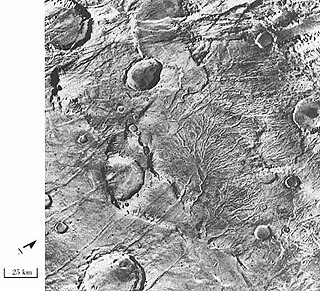
WValley networks are branching networks of valleys on Mars that superficially resemble terrestrial river drainage basins. They are found mainly incised into the terrain of the martian southern highlands, and are typically - though not always - of Noachian age. The individual valleys are typically less than 5 kilometers wide, though they may extend for up to hundreds or even thousands of kilometers across the martian surface.
 W
WThe Mars Exploration Rover mission successfully landed and operated the rovers Spirit and Opportunity on the planet Mars from 2004 to 2018. During Spirit's six years of operation and Opportunity's fourteen years of operation, the rovers drove a total of 52 kilometres on the Martian surface, visiting various surface features in their landing sites of Gusev crater and Meridiani Planum, respectively.
 W
WYardangs are common in some regions on Mars, especially in the Medusae Fossae Formation. This formation is found in the Amazonis quadrangle and near the equator. They are formed by the action of wind on sand sized particles; hence they often point in the prevailing direction that the winds were blowing when they were formed. Because they exhibit very few impact craters they are believed to be relatively young. The easily eroded nature of the Medusae Fossae Formation suggests that it is composed of weakly cemented particles, and was most likely formed by the deposition of wind-blown dust or volcanic ash. Yardangs are parts of rock that have been sand blasted into long, skinny ridges by bouncing sand particles blowing in the wind. Layers are seen in parts of the formation. A resistant caprock on the top of yardangs has been observed in Viking, Mars Global Surveyor, and HiRISE photos. Images from spacecraft show that they have different degrees of hardness probably because of significant variations in the physical properties, composition, particle size, and/or cementation.