 W
WBogićevica is a mountain area in the Prokletije. It spreads over Albania, Montenegro and Kosovo. It is about 15 km (9 mi) long and 10 km (6 mi) wide. The mountain area has a number of peaks higher than 2,000 m (6,562 ft) and two higher than 2,500 m (8,202 ft). Marijaš and Maja e Ropës are both located in Kosovo. The towns of Deçan in Kosovo and Tropojë in Albania are located near the area.
 W
WThe Maja e Çikës, at 2,044 metres (6,706 ft) above sea level, is the highest peak of the Ceraunian Mountains. The Ceraunians extends approximately 100 kilometres (62 mi) along the Albanian Riviera in a northwesterly direction from Sarandë to the Karaburun Peninsula. With a prominence of 1,563 metres (5,128 ft), Maja e Çikës is the 85th most prominent mountain peak in Europe.
 W
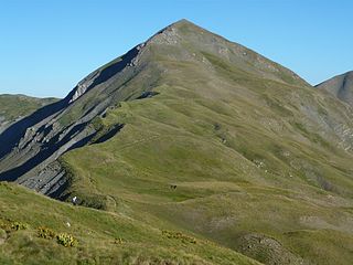
WDajti standing at 1,613 m (5,292 ft) above sea level, is a mountain and national park on the edge of Tirana, Albania. The Dajti belongs to the Skanderbeg range. In winter, the mountain is often covered with snow, and it is a popular retreat to the local population of Tirana that rarely sees snow falls. Its slopes have forests of pines, oak and beech, while its interior contains canyons, waterfalls, caves, a lake, and an ancient castle.
 W
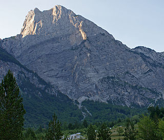
WDejë Mountain is a mountain in northern Albania. Dejë Mountains highest peak is Maja e Dejës which reaches a height of 2,245 m (7,365 ft). Dejë Mountain is part of Lura-Dejes Mountain National Park since 2018. The nearest village is Macukull, in Dibër County.
 W
WMount Dhëmbel is a mountain in southern Albania in the geographical region of Southern Mountain Range. It is part of the mountain chain Trebeshinë-Dhëmbel-Nemërçkë which goes parallel to the Shëndelli-Lunxhëri-Bureto chain.
 W
WDobra Kolata or Kolata e Mirë (in Albanian) is a mountain in the Kolata massif located in Albania and Montenegro, part of the Prokletije, standing at 2,528 m (8,294 ft) high.
 W
WGjallica or Gjallica e Lumës is a limestone mountain at 2,487 m (8,159 ft) above sea level and the highest summit in the region of Kukës County, Albania. It lies 8 km (5 mi) southeast of the city of Kukës, having a cap covered by snow up to June when the winters are cold and snowy.
 W
WGramos is a mountain range on the border of Albania and Greece. The mountain is part of the northern Pindus mountain range. Its highest peak, at the border of Albania and Greece, is 2,520 m (8,268 ft). The region is inhabited by Albanians, Aromanians and Greeks.
 W
WMaja e Këndrevicës is a mountain in Gjirokastër County, southern Albania. It is 15 km west of the town Tepelenë and 36 km southeast of the city Vlorë. At 2,121 m elevation, it is the highest point of the mountain range Mali i Gribës, which stretches between the valleys of the rivers Vjosë and Shushicë.
 W
WMount Korab is the highest peak of the eponymous mountain range and the fourth highest mountain entirely located in the Balkan Peninsula, standing at 2,764 metres.
 W
WKoritnik is a wooded, limestone mountain, located in northeastern Albania and southwest Kosovo between the cities of Kukës and Prizren. The mountain is entirely surrounded by branches of the White Drin river. The highest point of Koritnik massif, Maja e Pikëllimës reaches an elevation of 2,393 metres (7,851 ft) above the Adriatic. Gryka e Vanavës separates the mountain from Gjallica. The gorge is 3.5 km (2.2 mi) long, 30 m (100 ft) wide, and about 300 m (980 ft) deep.
 W
WMaja Bogiçaj is a peak of the Prokletije. It is located on the border of Kosovo and Albania. Bogiçaj is part of the Bogićevica mountain area and its peak is 2,405 m (7,890 ft) above sea level. One of the closest peaks is Tromeđa which is just found north-west of Bogiçaj peak.
WMaja Bojs is a 2,461-metre-tall (8,074 ft) mountain near the center of the Prokletije range in northern Albania near the border with Montenegro. It is just above the Buni Jezerce valley where Big lake of Buni Jezerce is located with five other lakes.
WMaja Briaset is a 2,567 m (8,422 ft) tall mountain located in the country of Albania. It is part of the Prokletije in the northern part of Albania. One of the surrounding valleys is Valbona Valley.
 W
WMaja e Hekurave is a mountain in the Bjeshkët e Namuna in the country of Albania. At 2,561 m (8,402 ft), it is one of the highest peaks in the mountain range. Maja Hekurave is a popular tourist spot.
 W
WMaja e Kakisë a mountain in the north of Albania. Maja e Kakisë is 2,357m high. It is located in the south of the large Prokletije not far from the smaller Maja e Ershellit which is found even more towards the south bordering the long Drin River.
 W
WMaja e Kollatës is the mountain peak in the Bjeshkët e Namuna range in northern Albania. Maja e Kollatës reaches a height of 2,556 m (8,386 ft) and is the highest among the four main peaks of the Kolata massif. The second and third highest are Zla Kolata and Dobra Kolata on the border to Montenegro just northwest of the main peak.
 W
WMaja e Papingut is a peak of the Nemërçkë mountain ridge located in the south of Albania, near the Vjosë river. Maja e Papingut is the highest point of Nemerçkë and the highest unshared peak in southern Albania at 2,482 m (8,143 ft) high. From the rocky summit there is a wonderful view of other Albanian mountains such as Tomorr and Gramos.
 W
WMaja e Popljuces is a mountain in Albania in the Prokletije. It is 2,569 m (8,428 ft) high and it itself is surrounded by many peaks above 2,500 m (8,200 ft). It is located just south of Maja Jezercë.
 W
WMaja e Thatë is a 2,406-metre-high (7,894 ft) mountain peak of the Albanian Alps (Prokletije) in Albania. It is located within Valbonë Valley National Park, roughly 2 km (1 mi) northwest of Valbonë and rises more than 1,500 m (4,921 ft) above the village. The mountain's southern and western lower slopes are relatively rich in beech and pine forests, while the higher slopes consist of very steep dolomite and limestone rock walls, suitable for mountaineering and rock climbing.
 W
WMaja Grykat e Hapëta is a mountain located in northern Albania in the Bjeshkët e Namuna. It is found to the southeast of Maja Jezercë, south of the upper Valbonë valley. It is one of the highest mountains in the mountain range at 2,625 m (8,612 ft) high. In fact, it is the third highest after Maja Jezercë at 2,694 m (8,839 ft) in Albania and Đeravica at 2,656 m (8,714 ft) in Kosovo. Like many of the other mountains surrounding it, Maja Grykat e Hapëta has a stony texture near its summit. Maja Grykat e Hapëta belongs to the group of peaks called Majet e Zabores where there are 10 peaks that are higher than 2,400 m (7,874 ft).
 W
WMaja Harapit is a mountain in the Prokletije range in the north of Albania. The mountain is 2,217 metres (7,274 ft) high, with its impressive 800 metres (2,600 ft) high south wall the northwestern edge of a large basin, where it dominates as a prominent rock formation, the conclusion of the Shala Valley and is one of the landmarks of Theth Valley. The mountain is on the edge of the National Parks Theth.
WJezerca Peak is the highest peak in the entire Dinaric Alps, the second highest in Albania and the sixth highest in the Balkans, standing at 2,694 m (8,839 ft) above sea level. It is one of the toughest if not one the most dangerous climbs in the Albanian Alps. However, Maja Jezercë is the 28th most prominent mountain peak on the European continent.
 W
WMali i Gjerë is a mountain in southern Albania. The highest peaks from north to south are Mali i Pusit, Mali i Frashërit and Mali i Nikollaqit.
 W
WMali i Gramës is a mountain in the Albanian part of the Korab mountain range. Mali i Gramës reaches a height of 2,345 metres high. Around the mountain are many lakes including the largest lake on Mount Korab which also shares the name 'Gramë'. It around one and a half kilometres west of Mount Korab itself, to which it is connected to the main part of the mountain by a long ridge.
 W
WMali i Thatë is a mountain in southeast Albania; with a part of it being in the southwest of North Macedonia with the highest altitude of 2287 meters. It borders Lake Prespa in the east, Lake Ohrid in northwest and overlooks the city of Pogradec to the west. It stretches 25 km from north to south and is 8 km wide in its central part. Mali i Thatë highest peak is Pllaja e Pusit and it reaches an altitude of 2,287 m (7,503 ft) above sea level. It is found within Albania, close to the Macedonian border. From this high peak, among several mountains of Albania, both Ohrid Lake and Prespa Lake can be seen as well as the third highest peak in North Macedonia, Baba Mountain or Pelister Mountain. The mountain has an anticlinal shape and is almost completely composed of mesozoic limestone formations. Mali i Thatë has craggy slopes, whereas its crest is almost flat but full of karstic cavities.
 W
WMunella is a mountain peak in Shkodër, Lezhë Albania.
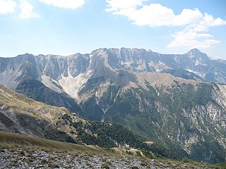
WNemërçka Mountains are a mountain range in southern Albania between Përmet and Gjirokastër District, which extends from a north-west direction to the south-east near the border between Albania and Greece. Geologically, Nemërçkë is a limestone-flysch forming a massive anticline situated between the graben valley of Vjosë river. The mountain forms the southern section of the Trëbëshinj-Dhëmbel-Nemërçka mountain chain. To the north, Nemërçkë is separated from the Albanian Pindus mountains, by the Vjosë river. The mountains are characterized by steep cliffs and wooden mountain slopes. The eastern scarps falls on the Vjosë river, 2000 metres down.
 W
WPaštrik or Pashtrik, is a mountain located in Kosovo and Albania. Its highest peak is located on their mutual border, it is also called Paštrik and it is 1,986 m (6,516 ft) high. The White Drin river passes along by it. Mount Pashtrik is the site of annual pilgrimages of residents from Has region of Prizren and Gjakova in Kosovo and from the border area of Albania.
 W
WRadohima is a mountain within the Albanian Alps in northern Albania.
 W
WRosni Peak is the highest peak of the Bjelić mountain, part of the Prokletije mountain range), located on the Montenegrin–Albanian border. It is 2,524 m high, making it the third highest mountain peak in Montenegro.
 W
WShebenik is a large mountain located in the Shebenik-Jabllanice National Park in eastern Albania. Shebenik has many peaks over 2,000 m (6,562 ft). The highest is Maja e Shebenikut at 2,253 m (7,392 ft) above sea level. It is found in the north-east of Shebenik. Around this peak are a number of small and large mountain lakes. Shebenik mountain is located west of Jablanica Mountain and northwest of Lake Ohrid. Shebenik is a great importance to wildlife preservation, especially because it is a home for the rare Eurasian lynx.
 W
WShkëlzen is a mountain in Albania with a height of 2,404 metres (7,887 ft). It is rocky and located near the border with Kosovo, north of Tropojë. It belongs to the Prokletije. Shkëlzen shares its name with a village that is just south of the mountain.
 W
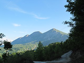
WTomorr is a mountain range in the region of Berat and Skrapar, in Albania. It reaches an elevation of 2,416 metres (7,927 ft) above sea level at the Çuka e Partizanit, which is the highest peak in central Albania.
WMount Trebeshinë is a mountain in southern Albania in the geographical region of Southern Mountain Range. It is part of the mountain chain Trebeshinë-Dhembel-Nemërçkë which goes parallel to the Shëndelli-Lunxhëri-Bureto chain.
WTromedja is a mountain in the Bogićevica area in the Prokletije range. Its peak which measures a height of 2,366 m (7,762 ft) above sea level forms a boundary between Albania, Kosovo and Montenegro. Albania contains the south of the mountain which is the majority of it, Kosovo the north-east and Montenegro the north-west. There is a valley in the Albanian and Kosovan side of the mountain. The village of Debërdol in Albania is located quite close to the summit.
 W
WThe Valamara is a mountain of the Central Mountain Range in Southeastern Albania. The mountain is roughly part of a series of mountains, extending from north-northeast to south-southwest between the valleys of Shkumbin in the north and Devoll in the south. It is one of the highest peaks in the European continent, in terms of topographic prominence.
 W
WZla Kolata is a mountain of the Prokletije on the border of Montenegro and Albania.