 W
WFollowing is a list of peaks in the Western Ghats:
 W
WAgasthyarkoodam is a 1,868-metre (6,129 ft)-tall peak of the Pothigai mountain range of Tamil Nadu in the Western Ghats of South India. The peak lies on the border of Tamilnadu and Kerala. This peak is a part of the Agasthyamala Biosphere Reserve which lies on the border between the Indian states of Kerala and Tamil Nadu. The perennial Thamirabarani River originates from the eastern side of the range and flows into the Tirunelveli district of Tamil Nadu.
 W
WThe Anaimalai or Anamala Hills, also known as the Elephant Mountains, are the range of mountains that form the southern portion of the Western Ghats and span the border of Tamil Nadu and Kerala in Southern India. The name anamala is derived from the Tamil/Malayalam word anai or ana, meaning elephant, and malai or mala, meaning hill – thus Elephant Hill.
 W
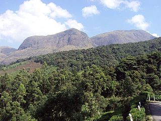
WAnamudi is a mountain located in the Indian state of Kerala. It is the highest peak in the Western Ghats and South India, at an elevation of 2,695 metres (8,842 ft) and a topographic prominence of 2,479 metres (8,133 ft). It lies on the border of Devikulam Taluk, Idukki district and Kothamangalam Taluk, Ernakulam district. The name Anamudi literally translates to "elephant's head" a reference to the resemblance of the mountain to an elephant's head. Anamudi Shola National Park (ASNP) was declared as National Park in December 2003 as per Notification No. 12876/F2 2003/F & WLD dated 14.12.2003 of Government of Kerala
 W
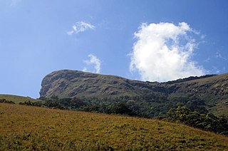
WAnginda peak is a mountain in the Nilgiri Hills of the Western Ghats in The Nilgiris District, Tamil Nadu, South India. It has an elevation of 2,383 metres (7,818 ft) and is the highest peak in Silent Valley National Park. It is just south of Sispara pass, and forms the southernmost boundary of Mukurthi National Park in Tamil Nadu. There is an unobstructed view of Anginda from the 30 m observation tower at Sairandhri Visitors Center.
 W
WBanasura Hill is one of the tallest mountains in the Western Ghats of the Wayanad district, Kerala, India. The hill is named after Banasura, a mythical character of Indian legends. It is one of the highest peak exceeding 2,000m between Nilgiris and Himalayas after Chembra Peak.
 W
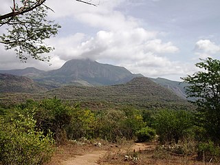
WThe Biligirirangana Hills, commonly called BR Hills, is a hill range situated in south-eastern Karnataka, at its border with Tamil Nadu in South India. The area is called Biligiriranganatha Swamy Temple Wildlife Sanctuary or simply BRT Wildlife Sanctuary. It is a protected reserve under the Wildlife Protection Act of 1972. Being at the starting point of the Eastern Ghats and very close to Western Ghats, the sanctuary is home to eco-systems that are unique to both the mountain ranges. The site was declared a tiger reserve in January 2011 by the Karnataka government, a few months after approval from India's National Tiger Conservation Authority.
 W
WThe Cardamom Hills or Yela Mala are mountain range of southern India and part of the southern Western Ghats located in southeast Kerala and southwest Tamil Nadu in India. Their name comes from the cardamom spice grown in much of the hills' cool elevation, which also supports pepper and coffee. The Western Ghats and Periyar Sub-Cluster including the Cardamom Hills, are UNESCO World Heritage Sites.
 W
WChembra Peak is one of the highest peak in the Western Ghats and the highest peak in Wayanad hills, at 2,100 m (6,890 ft) above sea level.
 W
WDattathreya Peeta is a mountain in range of the Western Ghats of India. Located in the Chikmagaluru taluk, Chikmagaluru District of Karnataka, Dattatreya peeta is known for its shrine to a pilgrimage site for Hindus .Sangh parivar organizations started "Datta Jayanti" celebrations in the late 2000s as part of their fight to claim "Sri Guru Dattatreya Swami Dattapit". People go to have a darshan of the dargah. The main peaks in this range are the Mullayanagiri and Baba Budangiri. Collectively, these peaks are known as Chandradrona Parvatha Shreni as they naturally form the shape of a crescent moon.
 W
WDevimala, is one of the 14 highest peak of Western Ghats in the (Devikulam) taluk of Idukki district of Kerala. Devimala Peak lies in the Anamalai hills of Kerala. It is located at the tea estate of Devikulam near to Munnar. It is the highest peak in the Devikulam hill station. It stands at an altitude of 2,521 m (8731 ft). Anamudi is located near to these peak. It is the seventh highest peak in South India.
 W
WDoddabetta is the highest mountain in the Nilgiri Mountains at 2,637 metres (8,652 feet). There is a reserved forest area around the peak. It is 9 km from Ooty, on the Ooty-Kotagiri Road in the Nilgiris District of Tamil Nadu, India. It is a popular tourist attraction with road access to the summit. It is the fourth highest peak in South India next to Anamudi, Mannamalai and Meesapulimala. The peaks Hecuba, Kattadadu and Kulkudi are the three closely linked summits in the west of the Doddabetta range near to Udagamandalam.
WElivai Mala is a 2,088-metre-tall (6,850 ft) peak in the Western Ghats of South India. The mountain lies in Palakkad district of Kerala, close to the border with Tamil Nadu. With a topographic prominence of 1,540 metres it is one of the ultra prominent peaks of South Asia. It forms the highest point in the Western Ghats to the immediate north of the Palakkad Gap. It is the highest peak in between Anamalai Hills and Nilgiri Hills in Western Ghats.
 W
WKalsubai is a mountain in the Western Ghats, located in the Indian state of Maharashtra. Its summit, situated at an elevation of 1,646 metres (5,400 ft), is the highest point in Maharashtra.
 W
WKemmannugundi is a hill station in Tarikere taluk of Chikkamagaluru district in the state of Karnataka, India. It is 1434m above sea level. This was the summer retreat of Krishnaraja Wodeyar IV and as a mark of respect to the king, it is also known as Sri Krishnarajendra Hill Station. The station is ringed by the Baba Budan Giri Range, with cascades, mountain streams, and lush vegetation, Kemmangundi’s has ornamental gardens and mountains and valleys views. There is a spectacular sunset view from the Raj Bhavan.
 W
WKodachadri is a mountain peak with dense forests in the Western Ghats in South India, 78km from Shimoga. It is declared as natural heritage site by the Karnataka Government. and it is 13th highest peak of Karnataka.
WKottamala (கோட்டைமலை/കോട്ടമല) near Rajapalayam in the Grizzled Squirrel Wildlife Sanctuary in Tamil Nadu and the adjoining Mlappara area of Periyar Wildlife Sanctuary in Kerala is a tall mountain peak situated in the Western Ghats at an altitude of 2,019m. It is one of the few tall peaks in the Western Ghats; and the highest peak of all in the Periyar plateau exceeding 2,000m.]).
 W
WKudremukha(ಕುದುರೆ ಮುಖ) is a mountain range and name of a peak located in Chikkamagaluru district, in Karnataka, India. It is also the name of a small hill station cum mining town situated near the mountain, about 20 kilometres from Kalasa. The name Kuduremukha literally means 'horse-face' (Kannada) and refers to a particular picturesque view of a side of the mountain that resembles a horse's face. It was also referred to as 'Samseparvata', historically since it was approached from Samse village. Kuduremukha is Karnataka's 2nd highest peak after Mullayanagiri. The nearest International Airport is at Mangalore which is at distance of 99 kilometres.
 W
WKumarikkal Mala is a peak situated in the Chinnar Wildlife Sanctuary in Kerala at an altitude of 2,522m above sea level. It is the highest peak in the Chinnar Wildlife Sanctuary and one of the highest peaks in Anamalai Hills exceeding 2,000m.
 W
WFollowing is a list of peaks in the Karnataka:
 W
WMahendragiri is the name of a hill in Tirunelveli District, South Tamil Nadu. The hill is located in Tirunelveli District and is part of the southern range of the Western Ghats, with an elevation of 1,645.2 metres (5,398 ft).
 W
WMale` Mahadeshwara Betta is a pilgrim town located in the Hanur taluk of Chamarajanagar district of southern Karnataka. It is situated at about 150 km from Mysuru and about 210 km from Bengaluru. The ancient and sacred temple of Sri Male Mahadeshwara is a pilgrim centre where Mahadeshwara lived, practiced medicine as Sidda,taught ahimsa to people in and around the seven hills.It draws lakhs of pilgrims from the states of Karnataka and Tamil Nadu. The area of the present temple surroundings is 155.57 acres (0.6296 km2). In addition, the temple has lands at Talabetta, Haleyuru and Indiganatha villages. Amidst dense forest, the temple attracts not only the pilgrims but also nature lovers. The height of the hill is about 3000 feet above sea level.
 W
WMatheran is a hill station and a municipal council in Karjat Tahsil in the Raigad district in the Indian state of Maharashtra. Matheran is part of the Mumbai Metropolitan Region. Matheran is one of the smallest hill stations in India. It is located on the Western Ghats range at an elevation of around 800 m above sea level. It is about 90 km from Mumbai, and 120 km from Pune. Matheran's proximity to many metropolitan cities makes it a weekend getaway for urban residents. Matheran, which means "forest on the forehead" is an eco-sensitive region, declared by the Ministry of Environment, Forest and Climate Change, Government of India. It is Asia's only automobile-free hill station.
 W
WMeesapulimala is the peak next south of the second highest peak of the Western ghats on Idukki District and Theni District border. Its peak is 2,640 metres (8,661 ft) above sea level. The name derives from its appearance from the southwest of a tiger with prominent whiskers ("Moustache"). It is located in between the Anaimalai Hills and Palani Hills near Suryanelli around 20km away from Munnar. Kolukkumalai tea estate, Top Station and Tipadamala (2135m) is also nearby.
 W
WMukurthi Peak is the one of the highest peaks in the Western Ghats of Tamil Nadu, India. It stand at an altitude of 2,554m (8,379ft). Mukurthi Peak is the fifth highest peak in South India. It is situated in the border of Udagamandalam taluk, Nilgiris, Tamil Nadu, and Nilambur taluk, Malappuram, Kerala. Western slope of the hill is kerala tamil nadu border ,with many cliffs from 2500m end upto to 500m, part of mukkuruthi-within malappuram district is the third highest point in kerala,after anaimudi (2696m)-idukki and meeshapulimala (2651m)-idukki, the place can be accessible only through nilgiri district,and no direct access from malappuram. Mukurthi peak resembles to "Pointed Nose".
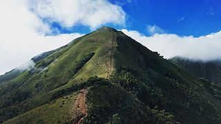
WMullayanagiri is the highest peak in Karnataka, India. Mullayyanagiri is located at 13°23′26″N 75°43′18″E in the Chandra Dhrona Hill Ranges of the Western Ghats of Chikkamagaluru Taluk. With a height of 1,930 metres (6,330 ft), it is the highest peak in Karnataka. The summit of Mullayanagiri houses a police radio relay station. Seethalayyanagiri is a prominent peak is adjacent to this place.
 W
WNedumpara Peak is one of the highest peak in the Western Ghats and is situated in Kollam district of Kerala, India, at an elevation of 900m. The peak is situated at Ambanad Hills near to Aryankavu. It is just 7 km away from Thenmala.
 W
WThe Nilgiri Mountains form part of the Western Ghats in western Tamil Nadu, India. At least 24 of the Nilgiri Mountains' peaks are above 2,000 metres (6,600 ft), the highest peak being Doddabetta, at 2,637 metres (8,652 ft).
 W
WPaithalmala is a hill station in the Kannur district of Kerala in India. Located near Pottenplave village, at a height of 1372 m above sea level, this is the highest geographic peak in Kannur. It is located at 40 km from Taliparamba and 65 km from Kannur. Nestled in the Kerala Karnataka border near to Kodagu forests, it lies in the Western Ghats. It has become a favourite spot for the nature enthusiasts, photographers, trekkers and leisurely visitors.
 W
WParunthumpara is a village in the Indian state of Kerala's Idukki District. It is a small scenic location near Wagamon en route to Peerumedu. Parunthin Para also known as 'Parunthumpara'. From here, the Makarajyothi of Sabarimala is visible. The main attractions of Parunthumpara are Suicide Point and Tagor Head. A nearby tourist spot is Thekkady.
 W
WPonmudi is a hill station in the Peringamala Panchayat of Trivandrum District of Kerala in India. It is located 53 km north-east of Trivandrum City, 78 km south-east of Varkala Beach and 69 km north-east of Kovalam Beach at an altitude of 1,100 m (3,600 ft). Ponmudi (Varayadumotta) peak is a part of the Western Ghats mountain range that runs parallel to the Arabian Sea. Ponmudi is also called Kashmir of Kerala and is a popular honeymoon destination in South India. The normal temperature of Ponmudi is between 18 and 25 °C.
 W
WThe Pothigai Hills, also known as the Shiva Jothi Parvath, Agasthiyar Mountain, Southern Kailash is a 1,866-metre -tall peak within Kalakkad Mundanthurai Tiger Reserve, Tamil Nadu is in the southern part of the Western Ghats of South India. However, peak lies in the border of Kerala and Tamil Nadu.. Ancient tradition holds the mountains of Pothigai to be where the sage Agastya provided the first grammar for the Tamil language. This grammar was further fine-tuned by one of his disciples in the Tolkāppiyam.
 W
WPushpagiri, at 1,712 metres (5,617 ft), is the highest peak in Pushpagiri Wildlife Sanctuary in the Western Ghats of Karnataka. It is located in the Somwarpet Taluk, 20 kilometres (12 mi) from Somwarpet in the northern part of Kodagu district on the border between Dakshina Kannada and Kodagu district and hassan districts. It is 4th highest peak of Karnataka. The Sanskrit name of the mountain is Puṣpagiri while its Prakrit form is Puphagiri, which is mentioned in the Nagarjunakond Second Apsidal Temple inscription, although this may refer to a different mountain to the north of Cuddapah, in Andhra Pradesh.
 W
WRangaswamy Peak and Pillar is a tourist spot in Kotagiri, The Nilgiris, Tamil Nadu. It is located at a distance of 20 km from Kotagiri. It is a very steep peak and not climbed yet. The hill station of Kotagiri has many tourist attractions spot, which include Kodanad View Point, Catherine Falls, Elk falls, Long wood Shola, Mekanad Falls and Rangaswamy Peak and Pillar. The best season to visit is in summer.
WSispara, സിസ്പാര, a proper noun, is a combination of the Badaga language words si:su + pore; meaning: magnetite bearing rock + gorge. It may refer to:Sispara peak, a large hill in Kerala; Sispara bungalow, the shelter at the base of the peak; Sispara pass, the low gap between hills where the shelter is located; or Sispara ghat, the mountain trail that goes through the pass.
 W
WVandaravu is the highest peak in the Palani hills in Tamil Nadu, India.
WVavul Mala is a peak in the Western Ghats in the Vellarimala range of Kerala, India. It is situated at the border of Malappuram district and Kozhikode district in Kerala. Vavulmala resembles to a "Camel Hump". Situated at a height of 2,339m, it is the highest peak in the Western Ghats northwards beyond the Nilgiris and also the highest point of Kozhikode district.These compact hills are faunatically and floristically similar to Nilgiri hills.
 W
WThe Velliangiri Mountains, a part of the Nilgiri Biosphere Reserve, are situated at the Western Ghats border of Coimbatore district, Tamil Nadu bordering Palakkad District, Kerala. Known as the "Sapthagiri, 7 Hills - Seven Mountains", these mountains are held and revered on par with spiritually most powerful place on the planet - Mount Kailash, the legendary abode of Lord Shiva. On the top of the Velliangiri Mountains, Shiva is worshipped as Swayambhu, one who is self-created and in this form, he graces the devotees.