 W
WThe Dinaric Alps, also commonly Dinarides, are a mountain range in Southern and Southeastern Europe, separating the continental Balkan Peninsula from the Adriatic Sea. They stretch from Italy in the northwest through Slovenia, Croatia, Bosnia and Herzegovina, Serbia, Montenegro, Kosovo to Albania in the southeast.
 W
WThis is a list of mountains in Montenegro.
 W
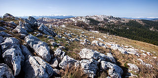
WBijela Gora is a karstic high plateau between 1200–1500 m on the northern side of Mount Orjen in Montenegro. At 1862 m, Velika Jastrebica is the highest summit. It bears heavy glacial traces as a huge ice cap covered it during the last ice age.
 W
WBioč is a mountain within the Sutjeska National Park, Bosnia and Herzegovina and Montenegro. It has an altitude of 2,388 metres (7,835 ft). The Piva runs nearby.
 W
WBjelasica is a mountain range located in the Biogradska Gora national park near Kolašin, Montenegro. The highest point of Bjelasica is Crna Glava, which is 2,139 m (7,018 ft) high.
 W
WBobotov Kuk is a peak in northern Montenegro. At 2,523 m (8,278 ft), it is the highest peak in the Durmitor mountain range and had been thought to be the highest point in Montenegro. New surveys have shown there are three higher peaks on the border with Albania. Most Montenegrin mountains are visible from Bobotov Kuk, among them Lovćen, Kopaonik and Tara, Maglić.
 W
WBogićevica is a mountain area in the Prokletije. It spreads over Albania, Montenegro and Kosovo. It is about 15 km (9 mi) long and 10 km (6 mi) wide. The mountain area has a number of peaks higher than 2,000 m (6,562 ft) and two higher than 2,500 m (8,202 ft). Marijaš and Maja e Ropës are both located in Kosovo. The towns of Deçan in Kosovo and Tropojë in Albania are located near the area.
 W
WDobra Kolata or Kolata e Mirë (in Albanian) is a mountain in the Kolata massif located in Albania and Montenegro, part of the Prokletije, standing at 2,528 m (8,294 ft) high.
WDurmitor is a massif located in northwestern Montenegro. It is part of the Dinaric Alps. Its highest peak, Bobotov Kuk, reaches a height of 2,523 meters (8,278 ft).
 W
WGarač is a mountain in central Montenegro, overlooking the city of Danilovgrad from the southwest. Its highest peak, Milunova bobija, is 1,436 meters high. Despite its relatively small height, its shape and prominence of circa 1400 meters, rising above the Zeta River Valley and Bjelopavlići, earned it the nickname "Montenegrin Kilimanjaro".
 W
WGradina is a mountain on the border of Serbia and Montenegro, between cities of Priboj and Pljevlja. Its highest peak Bandjer has an elevation of 1,446 m (4,744 ft) above sea level.
WHajla is a mountain located between Kosovo and Montenegro. It has several peaks that reach over 2,000 m (6,562 ft), the highest having 2,403 m (7,884 ft) which is also called Hajla. In the northern slopes contains the spring formation of the Ibar river, and to its southern slopes is the origin of the Bistrica e Pejes river. Hajla is also the highest mountain in the northern part of the Accursed Mountains of the Balkans. In Kosovo, Hajla forms part of the 25 km (16 mi) long Rugova Canyon. The nearest city to Hajla is Rožaje, in Montenegro.
 W
WHum is a mountain on the border of Serbia and Montenegro, between towns of Sjenica and Rožaje, on the eastern edge of Pešter plateau. Its highest peak Krstača has an elevation of 1,756 meters above sea level.
WJabuka is a mountain and plateau on the border between Serbia and Montenegro, between towns of Prijepolje and Pljevlja. Its highest peak Slatina has an elevation of 1,412 meters above sea level.
 W
WKamena Gora is a mountain on the border of Serbia and Montenegro, near the town of Prijepolje. It belongs to the Dinaric mountain range. Its highest peaks are Crni vrh on the Montenegrin side, and Ravna gora on the Serbian side, with an elevation of 1496 m each.
WKamenik is a Dinaric limestone mountain, located in Rovca region in central Montenegro.
 W
WKomovi is a mountain and mountain range in eastern Montenegro. It is a part of the Dinaric Alps. Its highest peak, Kom Kučki, reaches a height of 2,487 meters.
 W
WLebršnik is a mountain in the municipality of Gacko, East Herzegovina, at the border of Bosnia and Herzegovina and Montenegro. It has an altitude of 1,985 metres (6,512 ft).
 W
WLovćen is a mountain and national park in southwestern Montenegro. It is the inspiration behind the name of Montenegro; Crna Gora, was first mentioned in a charter issued by Stefan Milutin in 1276, the name Montenegro deriving from the appearance of Mount Lovćen when covered in dense forests.
WMaganik is a mountain range in Central Montenegro. The highest point of Maganik is Međeđi Vrh, which is 2,139 m (7,018 ft) high.
 W
WMaglić is transboundary mountain, on the border of Bosnia and Herzegovina and Montenegro.
 W
WMaja e Kollatës is the mountain peak in the Bjeshkët e Namuna range in northern Albania. Maja e Kollatës reaches a height of 2,556 m (8,386 ft) and is the highest among the four main peaks of the Kolata massif. The second and third highest are Zla Kolata and Dobra Kolata on the border to Montenegro just northwest of the main peak.
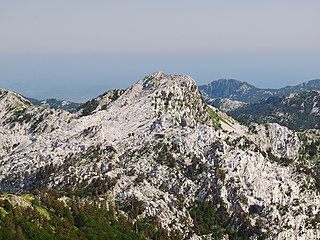
WOrjen is transboundary Dinaric Mediterranean limestone mountain range, located between southernmost Bosnia and Herzegovina and southwestern Montenegro.
 W
WProkletije, also known as the Albanian Alps and the Accursed Mountains, is a mountain group on the western Balkan peninsula. As a subrange of the 1,000-kilometre-long (621 mi) Dinaric Alps range (Dinarides), Prokletije extending from northern Albania to Kosovo, eastern Montenegro and southernmost Serbia. Its peak in Albania, Maja Jezercë at 2,694 m (8,839 ft), is the highest point, and the fourth highest peak in Albania and the highest in the Dinarides.
WRosni Peak is the highest peak of the Bjelić mountain, part of the Prokletije mountain range), located on the Montenegrin–Albanian border. It is 2,524 m high, making it the third highest mountain peak in Montenegro.
 W
WRumija is a mountain in southern Montenegro, situated between the Adriatic and Lake Skadar. The highest point is Rumija, which is 1,594 m (5,230 ft) high. Rumija rises above the town of Bar, and is a natural Dinaric barrier, separating the Adriatic from the Skadar basin. It is the southernmost mountain of Montenegro, and with prominence of 1,500 m (4,921 ft), one of the most prominent.
 W
WSinjajevina is a mountain in northern Montenegro. The highest point of Sinjajevina is Torna, which is 2,277 m (7,470 ft) high.
 W
WStožina is a peak in the Durmitor mountain range in northern Montenegro. At 1,908 m (6,260 ft), it is not among the highest peaks in the range, but due to its iconic shape and location, it has become a well-known symbol of the area and the Durmitor National Park.
 W
WTromedja is a mountain in the Bogićevica area in the Prokletije range. Its peak which measures a height of 2,366 m (7,762 ft) above sea level forms a boundary between Albania, Kosovo and Montenegro. Albania contains the south of the mountain which is the majority of it, Kosovo the north-east and Montenegro the north-west. There is a valley in the Albanian and Kosovan side of the mountain. The village of Debërdol in Albania is located quite close to the summit.
 W
WVelika Jastrebica is the highest summit of the Bijela Gora plateaux in the north of the Orjen range, and the second highest peak after Zubački kabao.
 W
WVisitor is a 2,209-metre-high (7,247 ft) mountain in the Dinaric Alps in Montenegro. It is situated west of Plav and Lake Plav, from which the river Lim flows.
 W
WVojnik is a mountain range located between the city of Nikšić and towns Šavnik and Plužine in western Montenegro. The name of the mountains means "soldier" in Montenegrin language. The highest point of Vojnik is the eponymous peak which is 1,998 m (6,555 ft) high.
 W
WVolujak is a mountain range on the border of Bosnia and Herzegovina and Montenegro. Geologically, Volujak is a subrange of the Dinaric Alps and formed largely of secondary and tertiary sedimentary rock, mostly limestone and dolomite. It basically forms a long ridge on the southwest side of the Suhja valley, with the border between Bosnia-Herzegovina and Montenegro running alongside this ridge, where a sharp corner of BiH territory reaches into Montenegro. It is on the BiH side located within the Sutjeska National Park but has a protected status also on the Montegrin side. Notable peaks are Volujak, Studenac, Badnjine and Trnovački Durmitor. Right at the northern foot of this last peak is the beautiful Trnovačko Lake situated. The Volujak range borders north-east on the Suhja valley and Maglić, on the south west side on the Izgori valley and the Lebršnik mountain group, in the north west by the Sutjeska (river) valley and on the south east side by the Bioč range. Volujak peak is the second highest elevation point in Bosnia Herzegovina. From its summit hikers obtain an impressive view of the surrounding peaks: Maglić, Veliko Vitao and, in the distance, Durmitor.
 W
WVrmac is a mountain in south-western Montenegro, overlooking the coastal town of Tivat and a peninsula dividing Tivat Bay from Kotor Bay.
 W
WVučji zub is at 1805 m one of the higher peaks in the Orjen masif.
WŽilindar is a mountain on the border of Serbia and Montenegro, between towns of Sjenica and Berane, on the central edge of Pešter plateau. Its highest peak Žilindar has an elevation of 1,616 meters above sea level.
 W
WZla Kolata is a mountain of the Prokletije on the border of Montenegro and Albania.
 W
WŽljeb Albanian: Zljeb) is a large mountain in south-western Serbia and Rožaje Municipality, eastern Montenegro. It is part of the Prokletije, located between the mountains of Hajla and Mokna. Nearly all the mountain is in the territory of Serbia. The White Drin river originates in the mountain.
 W
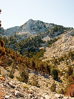
WVeliki kabao is a mountain peak on the border of Bosnia and Herzegovina and Montenegro. At 1,894 m, it is the highest summit of the Orjen range in the Dinaric Alps. It is also the highest peak of the eastern Adriatic.