 W
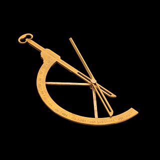
WAn alidade or a turning board is a device that allows one to sight a distant object and use the line of sight to perform a task. This task can be, for example, to draw a line on a plane table in the direction of the object or to measure the angle to the object from some reference point. Angles measured can be horizontal, vertical or in any chosen plane.
 W
WA Bilby tower is a type of steel survey tower used by the United States Coast and Geodetic Survey from 1927 to 1984. It is named after Jasper S. Bilby who designed it in 1926. In 1927, Herbert Hoover, the then Secretary of Commerce commended Bilby's tower "for its cost and time efficiency" and cited the surveyor's service as "essential to the United States government".
 W
WGeorg Friedrich Brander was an important maker of scientific instruments.
 W
WA circumferentor, or surveyor's compass, is an instrument used in surveying to measure horizontal angles. It was superseded by the theodolite in the early 19th century.
 W
WA goniometer is an instrument that either measures an angle or allows an object to be rotated to a precise angular position. The term goniometry derives from two Greek words, gōnia, meaning angle, and metron, meaning measure.
 W
WThe graphometer, semicircle or semicircumferentor is a surveying instrument used for angle measurements. It consists of a semicircular limb divided into 180 degrees and sometimes subdivided into minutes. The limb is subtended by the diameter with two sights at its ends. In the middle of the diameter a "box and needle" (compass) is fixed. On the same middle the alidade with two other sights is fitted. The device is mounted on a staff via a ball and socket joint. In effect the device is a half-circumferentor. For convenience, sometimes another half-circle from 180 to 360 degrees may be graduated in another line on the limb.
 W
WThe groma or gruma was a Roman surveying instrument. It comprised a vertical staff with horizontal cross-pieces mounted at right angles on a bracket. Each cross piece had a plumb line hanging vertically at each end. It was used to survey straight lines and right angles, thence squares or rectangles. They were stabilized on the high ground, and pointed in the direction it was going to be used. The helper would step back 100 steps and place a pole. The surveyor would tell him where to move the pole and the helper would set it down. The same name was given to:the center of any new military camp, i.e. the point from which was traced the regular grid by using the groma instrument the center of a new town, from which the gromatici (surveyors) began to lay out cardo and decumanus grid, with a plough and a pair of oxen
 W
WGunter's chain is a distance measuring device used for surveying. It was designed and introduced in 1620 by English clergyman and mathematician Edmund Gunter (1581–1626). It enabled plots of land to be accurately surveyed and plotted, for legal and commercial purposes.
 W
WIn surveying, a gyrotheodolite is an instrument composed of a gyrocompass mounted to a theodolite. It is used to determine the orientation of true north. It is the main instrument for orientation in mine surveying and in tunnel engineering, where astronomical star sights are not visible and GPS does not work.
 W
WThe heliotrope is an instrument that uses a mirror to reflect sunlight over great distances to mark the positions of participants in a land survey. The heliotrope was invented in 1821 by the German mathematician Carl Friedrich Gauss. The word "heliotrope" is taken from the Greek: helios, meaning "sun", and tropos, meaning "turn".
 W
WMax Hildebrand was a German mechanic and entrepreneur. His work helped to improve geodetic devices and the machines used to make them.
 W
WAn inclinometer or clinometer is an instrument used for measuring angles of slope, elevation, or depression of an object with respect to gravity's direction. It is also known as a tilt indicator, tilt sensor, tilt meter, slope alert, slope gauge, gradient meter, gradiometer, level gauge, level meter, declinometer, and pitch & roll indicator. Clinometers measure both inclines and declines using three different units of measure: degrees, percent, and topo. Astrolabes are inclinometers that were used for navigation and locating astronomical objects from ancient times to the Renaissance.
 W
WInvar, also known generically as FeNi36, is a nickel–iron alloy notable for its uniquely low coefficient of thermal expansion. The name Invar comes from the word invariable, referring to its relative lack of expansion or contraction with temperature changes.
 W
WThe term Jacob's staff, also known as cross-staff, a ballastella, a fore-staff, or a balestilha, is used to refer to several things. In its most basic form, a Jacob's staff is a stick or pole with length markings; most staffs are much more complicated than that, and usually contain a number of measurement and stabilization features. The two most frequent uses are:in astronomy and navigation for a simple device to measure angles, later replaced by the more precise sextants; in surveying for a vertical rod that penetrates or sits on the ground and supports a compass or other instrument.
 W
WIn surveying and construction, the laser level is a control tool consisting of a rotating laser beam projector that can be affixed to a tripod. The tool is leveled according to the accuracy of the device and projects a fixed red or green beam in a plane about the horizontal and/or vertical axis.
 W
WA laser line level is a tool combining a spirit level and/or plumb bob with a laser to display an accurately horizontal or vertical illuminated line on a surface the laser line level is laid against. Laser line levels are used wherever accurate verticals and horizontals are required, typically in the construction and cabinetry industries. Some models are inexpensive enough for do-it-yourself applications.
 W
WA laser rangefinder, also known as a laser telemeter, is a rangefinder that uses a laser beam to determine the distance to an object. The most common form of laser rangefinder operates on the time of flight principle by sending a laser pulse in a narrow beam towards the object and measuring the time taken by the pulse to be reflected off the target and returned to the sender. Due to the high speed of light, this technique is not appropriate for high precision sub-millimeter measurements, where triangulation and other techniques are often used.
 W
WA level is an optical instrument used to establish or verify points in the same horizontal plane in a process known as levelling, and is used in conjunction with a levelling staff to establish the relative heights levels of objects or marks. It is widely used in surveying and construction to measure height differences and to transfer, measure, and set heights of known objects or marks.
 W
WA measuring rod is a tool used to physically measure lengths and survey areas of various sizes. Most measuring rods are round or square sectioned; however, they can also be flat boards. Some have markings at regular intervals. It is likely that the measuring rod was used before the line, chain or steel tapes used in modern measurement.
 W
WThe optical square uses a pentaprism to reflect and refract a beam or sighting 90 degrees, it is used in pairs in surveying and in a singular block in metrology.
 W
WThe Osborne Fire Finder is a type of alidade used by fire lookouts in order to find a directional bearing (azimuth) to smoke in order to alert fire crews to a wildland fire.
WA pentaprism is a five-sided reflecting prism used to deviate a beam of light by a constant 90°, even if the entry beam is not at 90° to the prism. The beam reflects inside the prism twice, allowing the transmission of an image through a right angle without inverting it as an ordinary right-angle prism or mirror would.
 W
WA Philadelphia rod is a level staff used in surveying. The rod is used in leveling procedures to determine elevations and is read using a level.
 W
WA plumb bob, or plummet, is a weight, usually with a pointed tip on the bottom, suspended from a string and used as a vertical reference line, or plumb-line. It is a precursor to the spirit level and used to establish a vertical datum.
 W
WIn surveying, a pole is bar made of wood or metal and normally held vertical, upon which different instruments can be mounted: a prism, a GPS device, etc. It may be manufactured with a predetermined length or may be graduated for different heights or stages.
 W
WA retroreflector is a device or surface that reflects radiation back to its source with minimum scattering. This works at a wide range of angle of incidence, unlike a planar mirror, which does this only if the mirror is exactly perpendicular to the wave front, having a zero angle of incidence. Being directed, the retroflector's reflection is brighter than that of a diffuse reflector. Corner reflectors, and cat's eye reflectors are the most used kinds.
 W
WThe Ramsden surveying instruments are those constructed by Jesse Ramsden and used in high precision geodetic surveys carried out in the period 1784 to 1853. This includes the five great theodolites—great in name, great in size and great in accuracy—used in surveys of Britain and other parts of the world. Ramsden also provided the equipment used in the measurement of the many base lines of these surveys and also the zenith telescope used in latitude determinations.
 W
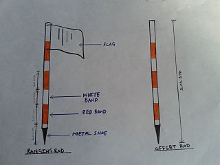
WA ranging rod is a surveying instrument used for marking the position of stations, and for sightings of those stations, as well as for ranging straight lines. Initially these were made of light, thin and straight bamboo, or of well seasoned wood such as teak, pine or deodar. They were shod with iron at the bottom and surmounted with a flag about 250 mm square in size. Nowadays they are made of wood, metal or fibreglass. The rods are usually about 30 mm in diameter and 2 m or 3 m long, painted with alternating bands, such as red and white, red and yellow, or black and white, in lengths of 200 mm, 500 mm, or one foot. These colours are used so that the rod can be properly sighted in case of long distance or bad weather. Ranging rods of greater length, e.g. 3 to 6 m, are called ranging or range poles, and are used for very long survey lines. Another type of ranging rod is known as an offset rod, which has no flag at the top. It is used for measuring small offsets from the survey line when the work is of an ordinary nature.
 W
WDeveloped from the reflecting circle, the repeating circle is an instrument for geodetic surveying, invented by Etienne Lenoir in 1784, while an assistant of Jean-Charles de Borda, who later improved the instrument. It was notable as being the equal of the great theodolite created by the renowned instrument maker, Jesse Ramsden. It was used to measure the meridian arc from Dunkirk to Barcelona by Jean Baptiste Delambre and Pierre Méchain.
 W
WA sight is an aiming device used to assist in visually aligning ranged weapons, surveying instruments or optical illumination equipments with the intended target. Sights can be a simple set or system of markers that have to be aligned together with the target, or optical devices that allow the user to see a sometimes optically enhanced image of the target aligned in the same focus with an aiming point. There are also sights that project an aiming point onto the target itself, such as laser sights and infrared illuminators on some night vision devices.
 W
WThe military sketching board was designed to be used on horseback. The board incorporates a compass, an inclinometer, a ruler, a roll of paper and an arm buckle.
 W
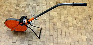
WA surveyor's wheel, also called a clickwheel, hodometer, waywiser, trundle wheel, measuring wheel or perambulator is a device for measuring distance.
 W
WA tape measure or measuring tape is a flexible ruler used to measure size or distance.
 W
WThe tellurometer was the first successful microwave electronic distance measurement equipment. The name derives from the Latin tellus, meaning Earth.
 W
WA theodolite is a precision optical instrument for measuring angles between designated visible points in the horizontal and vertical planes. The traditional use has been for land surveying, but they are also used extensively for building and infrastructure construction, and some specialized applications such as meteorology and rocket launching.
 W
WAn Abney level and clinometer, is an instrument used in surveying which consists of a fixed sighting tube, a movable spirit level that is connected to a pointing arm, and a protractor scale. An internal mirror allows the user to see the bubble in the level while sighting a distant target. It can be used as a hand-held instrument or mounted on a Jacob's staff for more precise measurement, and it is small enough to carry in a coat pocket.
 W
WA total station (TS) or total station theodolite (TST) is an electronic/optical instrument used for surveying and building construction. It is an electronic transit theodolite integrated with electronic distance measurement (EDM) to measure both vertical and horizontal angles and the slope distance from the instrument to a particular point, and an on-board computer to collect data and perform triangulation calculations.
 W
WA tribrach is an attachment plate used to attach a surveying instrument, for example a theodolite, total station, GNSS antenna or target to a tripod. A tribrach allows the survey instrument to be repeatedly placed in the same position over a surveying marker point with sub-millimetre precision, by loosening and re-tightening a lock to adjust the instrument base in a horizontal plane.
 W
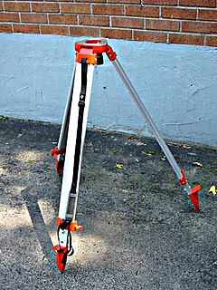
WA surveyor's tripod is a device used to support any one of a number of surveying instruments, such as theodolites, total stations, levels or transits.