 W
WThe Coconino National Forest is a 1.856-million acre United States National Forest located in northern Arizona in the vicinity of Flagstaff. Originally established in 1898 as the "San Francisco Mountains National Forest Reserve", the area was designated a U.S. National Forest in 1908 when the San Francisco Mountains National Forest Reserve was merged with lands from other surrounding forest reserves to create the Coconino National Forest. Today, the Coconino National Forest contains diverse landscapes, including deserts, ponderosa pine forests, flatlands, mesas, alpine tundra, and ancient volcanic peaks. The forest surrounds the towns of Sedona and Flagstaff and borders four other national forests; the Kaibab National Forest to the west and northwest, the Prescott National Forest to the southwest, the Tonto National Forest to the south, and the Apache-Sitgreaves National Forest to the southeast. The forest contains all or parts of ten designated wilderness areas, including the Kachina Peaks Wilderness, which includes the summit of the San Francisco Peaks. The headquarters are in Flagstaff. There are local ranger district offices in Flagstaff, Happy Jack, and Sedona.
 W
WAgassiz Peak is the second-highest mountain in the U.S. state of Arizona at 12,360 feet (3,767 m). It is located north of Flagstaff, Arizona in the San Francisco Peaks. It is in the Kachina Peaks Wilderness on the Coconino National Forest. The peak was named for Louis Agassiz, the naturalist.
 W
WAshurst Lake is a small lake located on the Anderson Mesa 20 miles (32 km) southeast of Flagstaff. It is one of the few natural lakes in the state of Arizona, the bulk of which reside in the area.
 W
WBlue Ridge Reservoir is located in the Mogollon Rim area of the state of Arizona. Clint Wells, Arizona. Blue Ridge Reservoir is one of the more scenic reservoirs in the area, with trees going down to the water line. The facilities are maintained by Coconino National Forest division of the USDA Forest Service.
 W
WCoconino Reservoir is located near Flagstaff in North Central Arizona and is just half mile south of Ashurst Lake. Recreational facilities are maintained under the authority of the Coconino National Forest.
 W
WDead Horse Ranch State Park is a state park of Arizona, United States, on the Verde River in an area known as the Verde River Greenway. Located at approximately 3,300 feet (1,000 m) elevation, Dead Horse Ranch State Park covers 423 acres (1.71 km2) of land with 10 miles (16 km) of hiking trails, 150 campground sites and several picnic areas, along with 23 group camping sites. It also offers trailhead access to the Dead Horse Trail System, located on adjacent Coconino National Forest land. The ranch was originally named by the Ireys family, who sold the land to the state of Arizona to become a state park.
 W
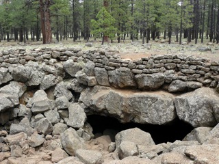
WElden Pueblo was a prehistoric Native American village located at the foot of Mount Elden near Flagstaff, Arizona. The pueblo is thought to have been part of a major trading system. Various trade items such as macaw skeletons from Mexico as well as shell jewelry from the coast of California have been found throughout the site. The area is now protected and is used for research and educational purposes.
 W
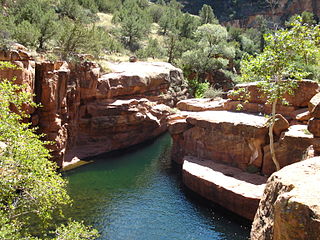
WFossil Springs Wilderness is an 11,550-acre wilderness area within the Coconino National Forest in the U.S. state of Arizona. It is at the bottom of a steep canyon at the edge of the Colorado Plateau, just south of the Mogollon Rim. Here, water emerges at the surface at the rate of about 2,700 cubic feet per minute. The perennial water supply supports one of the most diverse riparian ecosystems in the state, with more than 30 species of trees set among native desert shrub. It also creates a haven for abundant wildlife, including elk, deer, javelina, coyote, skunk, racoon, ring-tailed cat, fox, mountain lion, black bear and more than 100 species of birds.
 W
WFremont Peak is in the San Francisco Peaks of northern Arizona. It is the third highest point in the state of Arizona. The peak, named in honor John C. Frémont (1813–1890), is in the Kachina Peaks Wilderness on the Coconino National Forest.
 W
WThe Honanki Heritage Site is a cliff dwelling and rock art site located in the Coconino National Forest, about 15 miles (24 km) west of Sedona, Arizona. The Sinagua people of the Ancestral Puebloans, and ancestors of the Hopi people, lived here from about 1100 to 1300 AD. The Palatki Heritage Site is nearby, also in the Coconino National Forest.
WHouse Mountain is a shield volcano located in the U.S. state of Arizona located between the Sedona Red Rock Country and the Verde Valley in the Coconino National Forest. House Mountain erupted approximately 13-15 million years ago on the edge of where the Mogollon Rim stood at that time. Thus, the basalt that was emitted preserved the sedimentary layers below it, including the Schnebly Hill Formation and the thin band of Fort Apache Limestone. The Mogollon Rim has receded at a rate of 1 foot per 600 years since and the current edge of the rim can be seen several miles away from the summit.
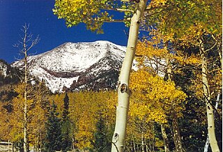
WHumphreys Peak is the highest natural point and the second most prominent peak after Mount Graham in the U.S. state of Arizona, with an elevation of 12,637 feet (3,852 m) and is located within the Kachina Peaks Wilderness in the Coconino National Forest, about 11 miles (17.7 km) north of Flagstaff, Arizona. Humphreys Peak is the highest of a group of dormant volcanic peaks known as the San Francisco Peaks.
 W
WKachina Peaks Wilderness is a 18,616-acre (75 km2) wilderness area about 6 miles (10 km) north of Flagstaff within the Coconino National Forest in the U.S. state of Arizona.
 W
WKendrick Mountain Wilderness is a 6,510-acre (26.3 km2) wilderness area in the U.S. State of Arizona. It lies north of the city of Flagstaff on the Coconino Plateau in Coconino County. Kendrick Mountain Wilderness was designated a protected Wilderness area by Congress in 1984. About two thirds of the wilderness is contained within the Kaibab National Forest. Kendrick Mountain Wilderness contains 10,418-foot (3,175 m) Kendrick Peak, upon which a fire lookout has been located since the early 1900s.
 W
WKendrick Peak or Kendrick Mountain is one of the highest peaks in the San Francisco volcanic field north of the city of Flagstaff in the U.S. State of Arizona and is located on the Coconino Plateau in Coconino County.
WKinnikinick Lake is located 38 mi (61 km) south of Flagstaff in North Central Arizona within the Coconino National Forest. Prairies of juniper surround the lake and typically abound with pronghorn. Bald eagles are often seen during the fall and winter months. The facilities are maintained under the authority of the Coconino National Forest.
 W
WKnoll Lake is part of the Blue Ridge Ranger District of the Coconino National Forest. It gets its name from a rocky island located in the middle of the lake. Knoll Lake is located in Leonard Canyon, Arizona, along the Mogollon Rim. This 75-acre (30 ha) lake is located at 7,340 feet (2,240 m) elevation and is closed to visitors in the winter months. Bald eagles may be seen during the winter months if the roads are open late into the season. The facilities are maintained by Coconino National Forest division of the USDA Forest Service.
 W
WLava River Cave is a lava tube in northern Arizona's Coconino National Forest. At approximately 0.75-mile (1.21 km) long, it is the longest cave of its kind known in Arizona. The cave was discovered by some lumbermen in 1915 and has historically been referred to as "Government Cave" due to its location on the eastern edge of Government Prairie and southeast of Government Peak. Today, Lava River Cave is freely accessible to the general public.
WLong Lake is located in the Mogollon Rim area of the state of Arizona. It is located 75 miles (121 km) southeast of Flagstaff. The facilities are maintained by Coconino National Forest division of the USDA Forest Service. It is named after a legend of a long serpent type creature that was reportedly seen by ranchers as they herd cattle near the lake.
WLake Mary may refer to one of two reservoirs in northern Arizona southeast of Flagstaff. The name may also be used to refer to the two lakes as a whole. The pair of lakes impound the intermittent Walnut Creek upstream from Walnut Canyon. Recreational facilities at both lakes are maintained under the authority of the Coconino National Forest.
WMazatzal Wilderness is a wilderness area of about 390 square miles in Yavapai and Gila counties in the U.S. state of Arizona. The wilderness is within the Tonto and Coconino national forests. The town of Payson is to the east, and the Verde River is to the west. During summer, temperatures in the wilderness often exceed 110 °F.
 W
WThe C. Hart Merriam Base Camp Site is a historic campsite in Coconino National Forest, north of Flagstaff, Arizona. It is significant for its association with Clinton Hart Merriam (1855–1942), the United States' first eco-biologist. The site was designated a National Historic Landmark in 1965.
 W
WMormon Lake is a shallow, intermittent lake located in northern Arizona in Pleasant Valley. With an average depth of only 10 ft (3.0 m), the surface area of the lake is extremely volatile and fluctuates seasonally. When full, the lake has a surface area of about 12 square miles (31 km2), making it the largest natural lake in Arizona. In particularly dry times, the lake has been known to dry up, leaving behind a remnant marsh.
WMunds Mountain Wilderness is an 18,150-acre wilderness area in the Coconino National Forest in the U.S. state of Arizona. It is immediately southeast of Sedona between Arizona State Route 179 and Interstate 17. The wilderness lies within the Munds Mountain and Sedona quadrangles of the national topographic map of the United States Geological Survey.
 W
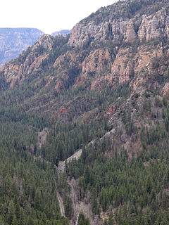
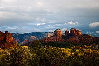
WOak Creek Canyon is a river gorge located in northern Arizona between the cities of Flagstaff and Sedona. The canyon is often described as a smaller cousin of the Grand Canyon because of its scenic beauty. State Route 89A enters the canyon on its north end via a series of hairpin turns before traversing the bottom of the canyon for about 13 miles (21 km) until the highway enters the town of Sedona.
 W
WThe Palatki Heritage Site is an archaeological site and park located in the Coconino National Forest, near Sedona, in Arizona, United States. In the Hopi language Palatki means 'red house'.
 W
WRed Rock State Park is a state park of Arizona, USA, featuring a red sandstone canyon outside the city of Sedona. The main mission of this day-use park is the preservation of the riparian habitat along Oak Creek. Red Rock State Park serves as an environmental education facility for the public and for school or private groups, and provides limited passive recreational opportunities.
 W
WThe Red Rock-Secret Mountain Wilderness is a 47,195-acre wilderness area located within the Coconino National Forest in the U.S. state of Arizona.
 W
WThe San Francisco Peaks are a volcanic mountain range in San Francisco volcanic field in north central Arizona, just north of Flagstaff and a remnant of the former San Francisco Mountain. The highest summit in the range, Humphreys Peak, is the highest point in the state of Arizona at 12,633 feet (3,851 m) in elevation. The San Francisco Peaks are the remains of an eroded stratovolcano. An aquifer within the caldera supplies much of Flagstaff's water while the mountain itself is in the Coconino National Forest, a popular recreation site. The Arizona Snowbowl ski area is on the western slopes of Humphreys Peak, and has been the subject of major controversy involving several tribes and environmental groups.
 W
WThe Schultz Fire is a wildfire which burned over 15,000 acres (6,100 ha), including Schultz Peak in Coconino National Forest near Flagstaff, Arizona in June 2010. The suspected cause is a campfire left unattended, and the United States Forest Service is offering a $2500 reward for information.
 W
WSlide Rock State Park is an Arizona State Park located in Oak Creek Canyon 7 miles (11 km) north of Sedona, Arizona, United States. It takes its name from a natural water slide formed by the slippery bed of Oak Creek. Slide Rock State Park is located on Coconino National Forest land and is co-managed by the Arizona State Parks agency and the United States Forest Service. Tall red rock formations that are typical of the region also surround the park, which contains a 43-acre (17 ha) working apple farm.
WSoldiers Lake is located 75 miles (121 km) southeast of Flagstaff in the state of Arizona. The facilities are maintained by Coconino National Forest division of the USDA Forest Service.
WStoneman Lake is a small lake located in northern Arizona, about 30 mi (48 km) south of the city of Flagstaff. Like the nearby Mormon Lake, it is one of the few natural lakes in Arizona.
 W
WSycamore Canyon is the second largest canyon in the Arizona redrock country, after Oak Creek Canyon. The 21-mile (34 km) long scenic canyon reaches a maximum width of about 7 miles (11 km). It is in North Central Arizona bordering and below the Mogollon Rim, and is located west and northwest of Sedona in Yavapai and Coconino counties.
WSycamore Canyon Wilderness is a 56,000-acre wilderness area in the Coconino, Kaibab and Prescott national forests in the U.S. state of Arizona. Encompassing Sycamore Canyon and its surrounds from south of Williams to the confluence of Sycamore Creek with the Verde River, the wilderness is about 40 miles southwest of Flagstaff. The canyon is one of several in Arizona that cut through the Mogollon Rim. Relevant United States Geological Survey (USGS) map quadrangles are Davenport Hill, White Horse Lake, May Tank Pocket, Perkinsville, Sycamore Basin, and Clarkdale. Red Rock-Secret Mountain Wilderness borders Sycamore Canyon Wilderness on the east.
 W
WThe Tinder Fire was a wildfire in East Clear Creek in Coconino National Forest, 1 1/2 miles northeast of Blue Ridge Reservoir in Arizona in the United States. The fire was caused by an illegal campfire and burned a total of 16,309 acres (66 km2). The fire was 100 percent contained on May 24, 2018.
 W
WThe V Bar V Heritage Site is the largest known petroglyph site in the Verde Valley of central Arizona, and one of the best-preserved. The rock art site consists of 1,032 petroglyphs in 13 panels. Acquired by the Coconino National Forest in 1994, the site is protected and kept open to the public by the US Forest Service. Volunteers from the Verde Valley Archaeological Society and the Friends of the Forest provide interpretive tours and on-site management.
 W
WThe Verde River is a major tributary of the Salt River in the U.S. state of Arizona. It is about 170 miles (270 km) long and carries a mean flow of 602 cubic feet per second (17.0 m3/s) at its mouth. It is one of the largest perennial streams in Arizona.
 W
WThe West Clear Creek Wilderness is a 15,238-acre wilderness area in the U.S. state of Arizona. West Clear Creek is formed by the junction of Willow Creek and Clover Creek in the Mogollon Rim, which is part of the Colorado Plateau; the Mogollon Rim is the major part of the Arizona transition zone at the southwest of the Colorado Plateau of Utah-Colorado, Arizona-New Mexico. Located east of Camp Verde, the area is part of Coconino National Forest. Common activities in West Clear Creek are swimming, camping, backpacking, hunting, fishing, and hiking. A variety of plants and animals can be found year-round, along with extremely cold water.
 W
WWet Beaver Wilderness is a 6,155-acre wilderness area located in the Coconino National Forest in the U.S. state of Arizona.