 W
WThe Coronado National Forest is a United States National Forest that includes an area of about 1.78 million acres (7,200 km2) spread throughout mountain ranges in southeastern Arizona and southwestern New Mexico.
 W
WGraptopetalum bartramii is a species of succulent plant known as Bartram's stonecrop and Patagonia Mountain leatherpetal.
 W
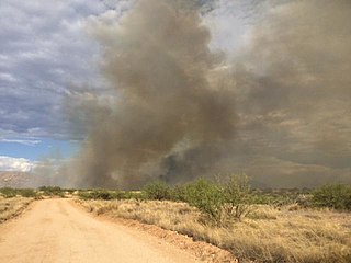
WThe Baker Canyon Fire was wildfire that began on March 3, 2016 northeast of Douglas, Arizona. By the time the fire was contained it had burned 7,980 acres (32.3 km2) of land in both Arizona and New Mexico.
 W
WBonita Canyon is a box canyon on the western slope of the Chiricahua Mountains in southeastern Arizona, which lies at 5,360 feet (1,630 m) in elevation and opens in a southwesterly direction into the Sulphur Springs Valley.
 W
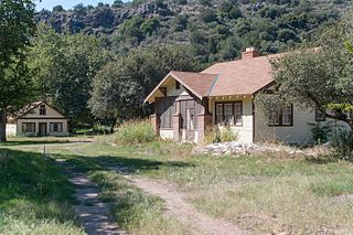
WCanelo Ranger Station, also known as Canelo Work Station, is a historic ranger station in the Coronado National Forest, within Santa Cruz County of southern Arizona. It is located in the ghost town of Canelo, within a small valley between the Canelo Hills on the west and the northern Huachuca Mountains on the east.
 W
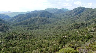
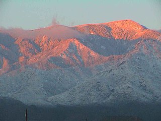
WThe Chiricahua Mountains massif is a large mountain range in southeastern Arizona which is part of the Basin and Range province of the west and southwestern United States and northwest Mexico; the range is part of the Coronado National Forest. The highest point, Chiricahua Peak, rises 9,759 feet (2,975 m) above sea level, approximately 6,000 feet (1,800 m) above the surrounding valleys. The range takes its name from the Chiricahua Apaches native to the region.
 W
WChiricahua National Forest was established as the Chiricahua Forest Reserve in Cochise County, Arizona by the General Land Office on July 1, 1902 with 169,600 acres (686 km2). After the transfer of federal forests to the U.S. Forest Service in 1905, it became a National Forest on March 4, 1907. On July 1, 1908 it absorbed Peloncillo National Forest, including lands in Hidalgo County, New Mexico. On July 1, 1917 Chiricahua was absorbed by Coronado National Forest and the name was discontinued.
WChiricahua Peak is the name of a 9,763 feet (2,976 m) peak located in the Chiricahua Mountains of southeastern Arizona, located about 35 miles (56 km) north of the United States–Mexico border. It is the highest summit in the Chiricahua Mountains and the highest point in Cochise County.
 W
WThe Columbine Work Station in Coronado National Forest near Safford, Arizona was built in 1935 by the Civilian Conservation Corps (CCC). The complex is a representative example of a Depression-era Forest Service administrative center. The station is on a high point of the Pinaleño Mountains in forested land. The main residence is in the Forest Service bungalow style. The barn is unique, not designed to a standard Forest Service prototype.
 W
WThe Cumero Fire was a wildfire burning southeast of Sasabe, Arizona, on the US-Mexico border in the Coronado National Forest in Arizona in the United States. The fire was reported on July 5 and burned 3,925 acres (16 km2). As of July 8, the fire was 80 percent contained. The cause of the fire is under investigation.
 W
WThe Dragoon Mountains are a range of mountains located in Cochise County, Arizona. The range is about 25 mi (40 km) long, running on an axis extending south-south east through Willcox. The name originates from the 3rd U.S. Cavalry Dragoons who battled the Chiricahua, including Cochise, during the Apache Wars. The Dragoons established posts around 1856 after the Gadsden Purchase made it a U.S. territory.
WDragoon National Forest was established in Arizona on May 25, 1907, with 69,120 acres (280 km2). On July 1, 1908, it was combined with Santa Catalina National Forest and Santa Rita National Forest to create Coronado National Forest. The name was discontinued.
 W
WEmpire Ranch is a working cattle ranch in southeastern Pima County, Arizona, that was placed on the National Register of Historic Places in 1976. In its heyday, Empire Ranch was one of the largest in Arizona, with a range spanning over 180 square miles, and its owner, Walter L. Vail, was an important figure in the establishment of southern Arizona's cattle industry.
WFrye Mesa Reservoir is located in southeastern Arizona, 15 miles (24 km) southwest of Safford in the Coronado National Forest.
 W
WGaliuro Wilderness is a 76,317-acre (309 km2) wilderness area encompassing the mid to upper slopes of the Galiuro Mountains. It is located within the Safford Ranger District of the Coronado National Forest in the American state of Arizona. It is bordered on the south by the Redfield Canyon Wilderness.
 W
WHarshaw Creek is a stream in the Patagonia Mountains of Santa Cruz County, Arizona, named after David Tecumseh Harshaw, who settled along its banks in the mid-1870s. It is approximately 15 miles (24 km) long and flows in a north to northwesterly direction toward the community of Patagonia, where it joins with Sonoita Creek.
 W
WHarshaw is a populated place in Santa Cruz County in the southeastern part of the U.S. state of Arizona. The town was settled in the 1870s, in what was then Arizona Territory. Founded as a mining community, Harshaw is named after the cattleman-turned-prospector David Tecumseh Harshaw, who first successfully located silver in the area. At the town's peak near the end of the 19th century, Harshaw's mines were among Arizona's highest producers of ore, with the largest mine, the Hermosa, yielding approximately $365,455 in bullion over a four-month period in 1880.
 W
WThe Huachuca Mountains are part of the Sierra Vista Ranger District of the Coronado National Forest in Cochise County in southeastern Arizona, approximately 70 miles (110 km) south-southeast of Tucson and southwest of the city of Sierra Vista. Included in this area is the highest peak in the Huachucas, Miller Peak, and the region of the Huachucas known as Canelo Hills in eastern Santa Cruz County. The mountains range in elevation from 3,934 feet (1,199 m) at the base to 9,466 feet (2,885 m) at the top of Miller Peak. The second highest peak in this range is Carr Peak, elevation 9,200 feet (2,804 m). The Huachuca Mountain area is managed principally by the United States Forest Service (41%) and the U.S. Army (20%), with much of the rest being private land (32%). Sierra Vista is the main population center.
 W
WKentucky Camp is a ghost town and former mining camp along the Arizona Trail in Pima County, Arizona, United States, near the community of Sonoita. The Kentucky Camp Historic District is listed on the National Register of Historic Places and has been since 1995. As it is located within Coronado National Forest, the United States Forest Service is responsible for the upkeep of the remaining buildings within the Kentucky Camp Historic District.
 W
WThe Little Dragoon Mountains, are included in the Douglas Ranger District of Coronado National Forest, in Cochise County, Arizona.
 W
WThe Lowell Ranger Station compound is in the Coronado National Forest of southern Arizona. It is located in Pima County, near Tucson.
 W
WMadera Canyon is a canyon in the northwestern face of the Santa Rita Mountains, twenty-five miles southeast of Tucson, Arizona. As part of the Coronado National Forest, Madera Canyon has campsites, picnic areas, and miles of hiking trails. The canyon is also used as a resting place for migrating birds, and it is thus known as a premier birdwatching area. Madera Canyon was originally named White House Canyon, after a prominent white adobe house was built there in the late 19th century. The canyon was renamed sometime in the early 1900s, although some locals still use the original name.
 W
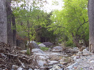
WMolino Canyon is a steep-sided, boulder-strewn canyon in the Santa Catalina Mountains northeast of Tucson, Arizona, next to the Molino Basin Campground. The canyon is located within the Coronado National Forest, and encompasses a wide variety of flora and fauna, ranging from lush pine forest in the canyon's upper reaches to Sonoran Desert cactus forest in the lower reaches. Catalina Highway was cut into the western side of the lower part of the canyon.
WMount Graham is a mountain in Graham County, Arizona, United States, approximately 70 miles (110 km) northeast of Tucson. The mountain reaches 10,724 feet (3,269 m) in height. It is the highest elevation in Graham County, Coronado National Forest and the Pinaleño Mountains It is also the southernmost peak and land area in the continental United States above 10,000 feet (3,048 m). As the name "Mount Graham" is often used by locals to refer to the entire mountain range, the peak itself is frequently referred to as "High Peak". It is twentieth of the 57 ultra prominent peaks of the lower 48 states, and the first of the five in Arizona.
 W
WMount Wrightson is a 9,456-foot (2,882 m) peak in the Santa Rita Mountains within the Coronado National Forest, in southern Arizona, United States.
 W
WPajarita Wilderness is a protected wilderness area managed by the Coronado National Forest in the U.S. state of Arizona. Established in 1984 under the Arizona Wilderness Act, the array of canyons that make up the area sit at the western end of the Pajarito Mountains, and form a well-known migration route for birds. Sycamore Canyon is the centerpiece of the wilderness, a riparian forest that supports more than 160 bird species.
 W
WParker Canyon Lake is located in southeastern Arizona, 28 miles (45 km) southwest of Sierra Vista around the Huachuca Mountains and about 5 miles (8.0 km) north of the border with Mexico. The lake is a reservoir formed by a dam in Parker Canyon in the south end of the Canelo Hills in southwestern Cochise County. Parker Canyon is a tributary to the Santa Cruz River in the San Rafael Valley. The facilities are maintained by Coronado National Forest division of the USDA Forest Service.
 W
WThe Patagonia Mountains are a 15-mile-long (24 km) mountain range within the Coronado National Forest, and in Santa Cruz County, Arizona, United States.
WPeña Blanca Lake is a reservoir in Arizona, United States, located 18 miles (29 km) northwest of Nogales. The facilities are maintained by the Coronado National Forest division of the USDA Forest Service. The lake was created in 1957 by the Arizona Game and Fish Department.Back then this lake was known for a plush resort that was located there. In 2008, the lake was closed to clean mercury contamination within the sediment, thought to be from old mines in the area. Also the former plush resort was removed as well. The lake was reopened in August 2009. In 2013, an Arizona Department of Environmental Quality report showed that mercury levels were similar to those before the lake was drained and dredged. One potential cause for the high mercury could be naturally occurring mercury seeping through the faults or a spring in the lake, though these claims are still under investigation.
 W
WThe Pinaleño Mountains, are a remote mountain range in southeastern Arizona, near Safford, Arizona. The mountains have over 7,000 feet (2,100 m) of vertical relief, more than any other range in the state. The mountains are surrounded by the Sonoran-Chihuahuan Desert. Subalpine forests cover the higher elevations. According to The Nature Conservancy, they traverse five ecological communities and contain "the highest diversity of habitats of any mountain range in North America." The highest point is Mount Graham at 10,720 feet (3,267 m). Locals often refer to the whole mountain range as "Mount Graham", in which case the peak is referred to as "High Peak". The mountains cover 300 square miles (780 km2) and are part of the Coronado National Forest, Safford ranger district.
 W
WThe Portal Ranger Station, also known as Portal Work Station, is located in Cave Creek Canyon, in the eastern Chiricahua Mountains, in Coronado National Forest near Portal, southeastern Arizona.
 W
WPusch Ridge Wilderness Area is a 56,430 acre (228.36 km2) wilderness area. It is located within the Coronado National Forest in the Santa Catalina Mountains north of Tucson, Arizona, United States. Established in 1978, the area varies greatly in elevation and biodiversity, rising from 2,800 feet to over 9,100 feet in elevation.
WRiggs Flat Lake is a reservoir located near the top of the Pinaleño Mountains, in the Coronado National Forest and Graham County, Arizona.
 W
WThe Rincon Mountains are a significant mountain range east of Tucson, Pima County, Arizona, in the United States. The Rincon Mountains are one of five mountain ranges surrounding the Tucson valley. The other ranges include the most prominent, the Santa Catalina Mountains to the north, the Santa Rita Mountains to the south, the Tucson Mountains to the west, and the Tortolita Mountains to the northwest. Redington Pass separates the Rincon Mountains from the Santa Catalina Mountains. The Rincon Mountains are generally less rugged than the Santa Catalina Mountains and Santa Rita Mountains. The Rincon Mountains are also included in the Madrean sky island mountain ranges of southeast Arizona, extreme southwest New Mexico, and northern Sonora Mexico.
WRosemont Copper is the name of a proposed new and large open pit copper mine project pursued by the Canadian mining corporation Hudbay Minerals. It has undergone a permitting review process under the direction of the United States Forest Service and the U.S. Army Corps of Engineers and has been delayed by legal judgements and suspension of its operating permit by the US Army Corps of Engineers. The project site is located within the Santa Rita Mountains and Coronado National Forest, in Pima County of southern Arizona.
 W
WSabino Canyon is a significant canyon located in the Santa Catalina Mountains and the Coronado National Forest north of Tucson, Arizona, United States. Sabino Canyon is a popular recreation area for residents and visitors of Southern Arizona, providing a place to walk, hike or ride. Minutes away from the desert are large waterfalls along Sabino Creek with minor bridges constructed over them. Wildlife in the canyon includes deer, javelina, skunks, tortoises, rattlesnakes and mountain lions.
 W
WThe Santa Catalina Mountains, commonly referred to as the Catalina Mountains or the Catalinas, are north and northeast of Tucson in Arizona, United States, on Tucson's north perimeter. The mountain range is the most prominent in the Tucson area, with the highest average elevation. The highest point in the Catalinas is Mount Lemmon at an elevation of 9,157 feet (2,791 m) above sea level and receives 180 inches (460 cm) of snow annually.
 W
WThe Santa Rita Mountains, located about 65 km (40 mi) southeast of Tucson, Arizona, extend 42 km (26 mi) from north to south, then trending southeast. They merge again southeastwards into the Patagonia Mountains, trending northwest by southeast. The highest point in the range, and the highest point in the Tucson area, is Mount Wrightson, with an elevation of 9,453 feet, The range contains Madera Canyon, one of the world's premier birding areas. The Smithsonian Institution's Fred Lawrence Whipple Observatory is located on Mount Hopkins. The range is one of the Madrean sky islands.
 W
WThe Sunflower Ranger Station, also known as Sunflower Administrative Site or Sycamore Ranger Station, in Tonto National Forest near Punkin Center, Arizona was built in 1935 by the Civilian Conservation Corps. It was listed on the National Register of Historic Places in 1993 for its architecture, which is Bungalow/Craftsman in style. It served historically as institutional housing and as government office space. The listing included two contributing buildings.
 W
WThe Whetstone Mountains is a mountain range in Cochise County, southeastern Arizona.