 W
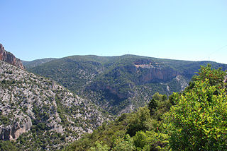
WThe Acarnanian Mountains is a mountain range in the northwestern part of the Aetolia-Acarnania regional unit in western Greece. It stretches from the village Monastiraki, near Vonitsa, in the north to Astakos in the south, with a total length of nearly 40 km. The Ionian Sea lies to the west.
 W
WAntichasia is a forested mountain range in the northern Trikala and Larissa regional units in Thessaly, Greece. The range is part of the eastern foothills of the Pindus mountains. Its highest point is 1,424 m elevation, in the eastern part of the mountains. The Meteora rocks near Kalampaka are considered part of Antichasia. Antichasia stretches from the valley of the river Mourgkani in the west to the valley of the river Titarisios in the east. Both are tributaries of the river Pineios, which flows southwest and south of the mountains. Its length is approximately 45 km from east to west. The nearest mountains ranges are Chasia to the northwest and Kamvounia to the northeast. The vast Thessalian Plain is to the south.
 W
WAroania, also known as Helmos or Chelmos, is a mountain range in Achaea, Peloponnese, Greece. At 2,355 m elevation, Aroania is the third highest mountain of the Peloponnese, after Taygetus and Kyllini, and the highest in Achaea. The largest town near the mountain is Kalavryta. The municipal unit Aroania took its name from the mountain.
 W
WAskio is a mountain range in the northwestern part of the Kozani and the eastern part of the Kastoria regional units in northern Greece. The elevation of its highest peak, Siniatsiko, is 2,111 m (6,926 ft). There are forests in the northern part. It stretches from the village Kleisoura in the northwest to Xirolimni in the southeast, over a length of about 30 km (19 mi). The nearest mountains are the Verno to the northwest, the Vourinos to the south and the Vermio to the northeast. It is drained by tributaries of the Aliakmonas to the west and south, and towards the Lake Vegoritida to the northeast.
 W
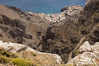
WThe Asterousia Mountains are a range in southern Crete separating the Messara Plain from the Libyan Sea. Evidence of ancient Cretan cultures have been found in excavations performed within sites contained in this range; moreover, one of the most significant Minoan sites on Crete has been excavated at nearby Phaistos to the north; apparently, the Phaistos palace was designed to permit views over the expansive Messara Plain and the Asterousi Mountains. A further historical name for this range is reported by Encyclopædia Britannica as the Kofinos Range, named after the highest peak of Asteroussia, Kofinas.
 W
WAthamanika or Tzoumerka is a mountain range in northwestern Greece, part of the wider Pindus mountain range. Its highest point is the mountain Kakarditsa, at 2,429 m. Its length is approximately 40 km from north to south and its width is approximately 15 to 20 km from east to west. The only major road crossing the Athamanika is the Greek National Road 30.
 W
WBelasica, Belles or Kerkini, is a mountain range in the region of Macedonia in Southeastern Europe, shared by northeastern Greece, southeastern North Macedonia (35%) and southwestern Bulgaria (20%).
WChasia is a forested mountain range in the northern Trikala (Thessaly) and the southern Grevena regional units, northern Greece. It is an eastern extension of the Pindus mountain range. The elevation of its highest peak, Kratsovo, is 1,564 m (5,131 ft). It stretches from the village Korydallos in the west to Kerasoula in the east, over a length of about 35 km (22 mi). The nearest mountains are the Antichasia to the south, the Kamvounia to the northeast and the Lygkos to the west. It is drained by tributaries of the Aliakmonas to the north, and by the Pineios and its tributary Mourgkani to the south.
WCithaeron or Kithairon is a mountain and mountain range about ten miles long, in central Greece. The range is the physical boundary between Boeotia in the north and Attica in the south. It is mainly composed of limestone and rises to 1,409 metres (4,623 ft). The north-east side of the range is formed by the mountain Pastra.
 W
WDikti or Dicte is a mountain range on the east of the island of Crete in the regional unit of Lasithi. On the west it extends to the regional unit of Heraklion. According to some versions of Greek mythology, Zeus was reared on this mountain in a cave called Dictaeon Antron. On the north of the main massif, the Lasithi Plateau is located. The topology of the mountain range is rich with plateaus, valleys and secondary peaks. Some important peaks are Spathi 2148m, Afentis Christos/Psari Madara 2141m, Lazaros 2085m, Madara 1783m, Skafidaras 1673m, Katharo Tsivi 1665m, Sarakino 1588m, Afentis 1571m, Selena 1559m, Varsami 1545m, Toumpa Moutsounas 1538m, Platia Korfi 1489m, Mahairas 1487m, Virgiomeno Oros 1414m,. The main massif forms a horseshoe around the valley of Selakano. Large parts of the mountain area, including the Selakano valley, are forested with pines, Kermes oaks, cypresses, Holm Oaks and Cretan Maples. The fertile valleys and plateaus of Dikti/Dicte are of significant importance in the local economy.
 W
WErymanthos, also Olonos (Ωλονός), is a mountain range in the southern part of Achaea and the northeastern part of Elis in Greece. Erymanthos is the fourth-tallest mountain in the Peloponnese peninsula and the mount's highest peak is Olonos with an elevation at 2,224 m. Historicathos was part of northwestern Arcadia, where it was the second-tallest mountain range. The northern portion belonged to the historic Achaea.
 W
WGeraneia Mountains or Yerania Ori are a mountain range in Corinthia and West Attica, Greece. Its highest point is the peak Makryplagi, elevation 1,351 m. It covers the northern part of the isthmus between the Gulf of Corinth and the Saronic Gulf. It spans 5–10 km from north to south and 30 km from east to west.
 W
WHymettus, also Hymettos, is a mountain range in the Athens area of Attica, East Central Greece. It is also colloquially known as Trellós (crazy) or Trellóvouno ; the latter originates from the French "très long" in awe of its winding length of 16km, as used by French travelers during the occupation of Greece by the Ottomans. In antiquity there was a sanctuary to Zeus Ombrios on the summit with numerous offerings dating especially to the 8th-7th centuries BC; they are on the site of a military base and not currently accessible. There is also an ancient quarryman's hut on the western slopes of the mountain, one of two buildings in ancient Attica which preserves its roof.
 W
WKantili is a mountain range in the northwestern part of the island of Euboea in Greece. Its maximum elevation is 1,246 m. It stretches along the west coast of the island, above the shore of the North Euboean Gulf, between Limni and Politika. Its length is about 25 km from southeast to northwest. The slope towards the sea is very steep, and there is no road along the coast. The Greek National Road 77 passes east of the mountains.
WLefka Ori or Madares is a mountain range located in Western Crete, in the Chania prefecture. The White Mountains or Lefka Ori occupy a large part of the centre of West Crete and are the main feature of the region. They consist mainly of limestone, from light grey to bluish or black color. The "White Mountains" have got their name from the perpetual white or off white color of their peaks as the off white of limestone during the summer and fall interchanges with the snow that covers the peaks until late in spring.
 W
WMenoikio is a mountain range in the eastern Serres and western Drama regional units in Greece. The highest peak of the mountain is Mavromata at 1,963 m.
WThe Messapio is a small mountain range located in the northeastern part of Boeotia and the mainland part of Euboea regional unit in central Greece. It borders on the North Euboean Gulf and the Euripus Strait to the north and east. Its highest point is 1,021 m. It is 20 km long and 10 to 15 km wide and covers an area of 300 km². It separates the area around Chalcis from the Boeotian plains around Thebes. In the south, on the slope of the 740 m high mountain Ypato, there is the monastery of the Transfiguration of the Saviour. The nearest mountain ranges are the Ptoo to the northwest. The Motorway 1 passes south of the mountain.
WMitsikeli is a mountain range in the central part of the Pindus mountains, in Epirus, Greece. The mountain is located northeast of Ioannina and Lake Ioannina. Its highest elevation is 1,810 m. It stretches from near Kalpaki in the northwest to the eastern end of Lake Ioannina, a total length of 35 km. The northeastern slopes and the lower northwestern part of Mitsikeli are forested. The nearest mountains are the Tymfi to the north, the Lygkos to the northeast and the Lakmos to the east. It is drained by tributaries of the Thyamis to the northwest, towards Lake Ioannina to the southwest, by the Voidomatis to the northeast and by the Arachthos to the southeast.
 W
WMovri is a forested mountain range in western Achaea, Greece. Its highest point is 719 m amsl. It covers part of the municipal units Movri, Dymi, Larissos and Olenia, all in the municipality of West Achaea. It is located about 30 km southwest of Patras. The higher mountain range Skollis lies to its southeast. The river Larissos has its source in the Movri, and flows to the west.
 W
WMountain Paiko or Pajak in Bulgarian and Macedonian is a small mountain range that lies on the border of the Pella and Kilkis regional units in Central Macedonia, Greece.
 W
WThe Panachaiko, also known as Vodias (Βοδιάς) mainly at the Middle Ages, is a mountain range in Achaea, Peloponnese, Greece. It spans about 20 km in length from north to south, and 15–20 km from east to west. It is the northernmost mountain range in the Peloponnese. The highest point, named Pyrgos Palavou, is 1,926 m.
WPanaitoliko is a mountain range in the northeastern part of Aetolia-Acarnania and southwestern Evrytania, in western Greece. Its highest summit, Kyra Vgena, is the highest point of Aetolia-Acarnania at 1,924 m. Its length is approximately 25 km long from east to west and its width is approximately 15 km wide. The nearest mountains are Kaliakouda to the northeast, the mountains of Nafpaktia to the southeast and Valtou to the northwest. Lake Trichonida lies to the south. The Panaitoliko extends from the Acheloos valley in the northwest to the Evinos valley in the east. There are forests in the lower areas, and grasslands in the higher elevations.
 W
WThe Pangaion Hills are a mountain range in Greece, approximately 40 km from Kavala. The highest elevation is 1,956 m and the mountaintop name is Koutra. The Aegean Sea lies to the south and the plains of Philippi-Kavala to the north. The mountain range covers the southeastern portion of the Serres regional unit as well as northwestern part of the Kavala regional unit which includes the bigger part of the hills.
 W
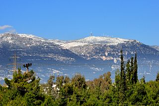
WMount Parnitha is a densely forested mountain range north of Athens, the highest on the peninsula of Attica, with an elevation of 1,413 m, and a summit known as Karavola (Καραβόλα). Much of the mountain is designated a national park, and is a protected habitat for wildfowl, first created in 1961. The summit is located 18 km north of Acharnae and about 30 km north of Athens city centre, while the mountain covers approximately 250 km² of land. Other peaks include Mavrovouni (Μαυροβούνι), Ornio, Area, Avgo or Avgho, and Xerovouni. It also has two shelters Mpafi and Flampouri. The name of the mountain dates back to ancient times, when it was under the ancient demes of Acharnae and Decelea.
 W
WParnon or Parnonas or Malevos (Μαλεβός) is a mountain range, or massif, on the east of the Laconian plain and the Evrotas valley. It is visible from Athens above the top of the Argive mountains. The western part is in the Laconia prefecture and the northeastern part is in the Arcadia prefecture. The Parnon range separates Laconia from Arcadia. Its summit offers panoramic views of southeastern Arcadia and South Kynouria and much of Laconia that includes the northern and the central portions and reaches as far as the Taygetos mountains. It also views a part of the central Arcadia and the southern Argolis prefectures. It views the Myrtoan and the Laconian Gulfs.
 W
WMount Pentelicus or Pentelikon is a mountain in Attica, Greece, situated northeast of Athens and southwest of Marathon. Its highest point is the peak Pyrgari, with an elevation of 1,109 m. The mountain is covered in large part with forest, and can be seen from southern Athens (Attica), the Pedia plain, Parnitha, and the southern part of the northern suburbs of Athens. Houses surround the mountain, especially in Vrilissia, Penteli, Ekali, Dionysos and north of Gerakas. Marble from Mount Pentelicus is of exceptionally high quality and was used to construct much of the Athenian Acropolis. Later, Pentelic marble was exported to Rome, where it was used in construction and in sculptures.
 W
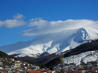
WThe Pierian Mountains are a mountain range between Imathia, Pieria and Kozani Region, south of the plain of Kambania in Central Macedonia, Greece. The village of Vergina, where the archaeological site of ancient Aigai lies, is built at the foot of these mountains. The highest point in the range is Flampouro at 2,193m .The Pierian Mountains are the site of the ski resort of Elatochori.
 W
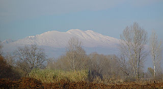
WThe Pindus is a mountain range located in northern Greece and southern Albania. It is roughly 160 km long, with a maximum elevation of 2,637m. Because it runs along the border of Thessaly and Epirus, the Pindus range is known colloquially as the spine of Greece. The mountain range stretches from near the Greek-Albanian border in Northern Epirus, entering the Epirus and Macedonia regions in northern Greece down to the north of the Peloponnese. Geologically it is an extension of the Dinaric Alps, which dominate the western region of the Balkan Peninsula.
 W
WThe Rhodopes are a mountain range in Southeastern Europe, with over 83% of its area in southern Bulgaria and the remainder in Greece. Golyam Perelik is its highest peak at 2,191 meters (7,188 ft). The mountain range gives its name to the terrestrial ecoregion Rodope montane mixed forests that belongs in the temperate broadleaf and mixed forests biome and the Palearctic realm. The region is particularly notable for its karst areas with their deep river gorges, large caves and specific sculptured forms, such as the Trigrad Gorge.
 W
WThe Taygetus, Taugetus, Taygetos or Taÿgetus is a mountain range on the Peloponnese peninsula in Southern Greece. The highest mountain of the range is Mount Taygetus, also known as "Profitis Ilias", or "Prophet Elias". The name is one of the oldest recorded in Europe, appearing in the Odyssey. In classical mythology, it was associated with the nymph Taygete. During Byzantine times and up until the 19th century, the mountain was also known as Pentadaktylos.
 W
WTelethrio is a small mountain range in the northwestern part of the island of Euboea, Greece. Its maximum elevation is 970 m. It stretches along the west coast of the island, on the North Euboean Gulf, from Aidipsos in the west to Rovies in the east. Its length is about 16 km from east to west. The mountain is forested. There are few villages on the steep southern slope, including Ilia. Villages on the northern slope are Taxiarchis, Kastaniotissa, Galatsades, Kamatriades and Simia.
WThrypti or Sitia mountains is a mountain range in Lasithi in eastern Crete, Greece. It stretches between Ierapetra in the southwest and Sitia in the northeast. Its highest summit, Afentis, is 1,476 m amsl.
 W
WThe Vermio Mountains, the ancient Bermion, is a mountain range in northern Greece. It lies between the Imathia Regional Unit of the Central Macedonia Region and the Kozani Regional Unit of the Western Macedonia Region. The range is west of the plain of Kambania. The town of Veria, which is the capital of Imathia, is built on the foot of these mountains. The highest point in the range is the peak Chamiti, 2,065 metres (6,775 ft) elevation, west of Naousa.
 W
WVerno or Vitsi is a forested mountain range in the southern part of the Florina and the northeastern part of the Kastoria regional units in northern Greece. The elevation of its highest peak, Vitsi, is 2,128 m (6,982 ft). It stretches from the village Trivouno in the northwest to Kleisoura in the southeast, over a length of about 30 km (19 mi). The nearest mountains are the Askio to the southeast, the Baba to the north and the northern Pindus to the southwest. It is drained towards the river Sakoulevas to the northeast, and towards the Aliakmonas and Lake Kastoria to the southwest.
 W
WVoio is a mountain range in the southwestern Kastoria and western Kozani regional units in Greece. The mountain is part of the Pindus mountains. Its highest elevation is 1,805 m. It is a densely forested and sparsely populated mountain range. It is drained towards the river Sarantaporos in the west and towards the Aliakmonas in the east. The nearest mountain ranges are Gramos to the west and Smolikas to the southwest.
 W
WThe Voras Mountains, also known as Nidže are a mountain range situated on the border between Greece and North Macedonia. It separates the Pella regional unit on the Greek side in the south from the Mariovo region on the North Macedonia side in the north. The tallest peak in the range is Kaimakchalan at 2,524 m (8,281 ft). Adjacent peaks are Starkov grob and Dobro Pole.
 W
WVourinos is a mountain range covering the eastern Grevena and southern Kozani regional units in Greece. Its highest elevation is 1,866 metres (6,122 ft). Its length is approximately 30 km (19 mi) from northwest to southeast. It is drained by the river Aliakmonas and its tributaries. There are forests on the northern slopes and the lower areas, the higher elevations are covered with grasslands. The nearest mountain ranges are Askio to the north and Kamvounia to the southeast.
 W
WVrontous is a mountain range in the northeastern Serres and the westernmost Drama regional units in Greece. Its highest peak is the Ali Babas at 1,849 m elevation. Other notable peaks are the Kour Lof, Mavro vouno, Siderovouni and Sarligia. It is a densely forested and sparsely populated mountain range. It stretches between the village Vamvakofyto in the southwest and Perithori in the northeast, over a length of about 35 km. The nearest mountains are the Slavyanka/Orvilos to the north and the Menoikio to the southeast.
WThe Zarkos is a small mountain range in central Thessaly in Greece. It is situated on the border of the Larissa and the Trikala regional unit. Its highest point is 734 m. It is 15 km long and 12 km wide and covers and area of 100 to 150 km². Grasslands are in the lower elevations and forests in the higher elevations. It is drained by the river Titarisios to the north and the Pineios to the south.
 W
WZavitsa is a mountain in the Peloponnese, known in antiquity as Timenion Oros, meaning Timenion mountain. Its contemporary name comes from the slavic word "zavičaj" which means "homeland". It lies on the northeastern edges of Arcadia, marking the natural boundaries with Argolis to the north. Its highest peak is Profitis Ilias rising at 974 meters above sea level. Its easternmost slopes reach the Arcadian coasts that form part of the wider Argolic Gulf area. Xiropigado, Kato Vervena, Kato Doliana and Prosilia are villages located around its slopes.