 W
WThe Aiguilles de Baulmes are a mountain of the Jura range, located north of Baulmes in the canton of Vaud.
 W
WThe Belchenflue is a mountain of the Jura, located on the border between the Swiss cantons of Basel-Landschaft and Solothurn, south of Eptingen. The nearby Belchenflue Pass links the two cantons.
 W
WThe Chasseral is a mountain of the Jura Mountains, overlooking Lake Biel in the Swiss canton of Bern. With an elevation of 1,606 metres above sea level, the Chasseral is the highest summit in the canton of Bern outside the Alps. It is also both the northernmost and easternmost mountain reaching over 1,500 metres in the Jura Mountains. West of the summit is located the Chasseral Ouest, where runs the border with the canton of Neuchâtel. The Chasseral Pass is located further on the west.
 W
WThe Chasseral Ouest is a prominence west of the Chasseral, in the Jura Mountains. It is located on the border between the Swiss cantons of Neuchâtel and Bern. The Chasseral Ouest reaches an elevation of 1,552 metres above sea level and is the highest point of the canton of Neuchâtel.
 W
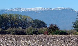
WLe Crêt de la Neige is the highest peak in the Jura Mountains and the department of Ain in France. Its elevation is 1720 m above sea level. Its prominence is 1260 m. It is located in the commune of Thoiry.
 W
WThe Crêt du Cervelet is a mountain of the Jura, located between La Brévine and Couvet in the canton of Neuchâtel.
 W
WThe Dent de Vaulion is a mountain peak of the Swiss Jura, overlooking the lake of Joux and Vaulion in the canton of Vaud.
 W
WThe Faux d'Enson is a mountain of the Jura, located south of Roche-d'Or in the canton of Jura. At an elevation of 927 m (3,041 ft) it is one of the highest summits in the region of Ajoie. An observation tower is located on the top.
WThe Geissflue is a hill of the eastern Jura Mountains, located between the Swiss cantons of Basel-Landschaft and Solothurn. The border with the canton of Aargau runs east of the summit on the Geissfluegrat.
 W
WThe Geissfluegrat is a minor summit east of the Geissflue, in the eastern Jura Mountains. It is located between the Swiss cantons of Aargau and Solothurn. With an elevation of 908 metres above sea level, the Geissfluegrat is the highest point in Aargau. It is also the easternmost summit above 900 metres in the Jura Mountains.
WThe Grand Som Martel is a mountain of the Jura, located between Le Locle and Les Ponts-de-Martel in the canton of Neuchâtel.
 W
WThe Grenchenberg is a mountain of the Jura, located on the border between the Swiss cantons of Bern and Solothurn. The mountain is named after the town of Grenchen, located on its south side.
 W
WThe Hasenmatt is a mountain of the Jura range, located north of Grenchen and Solothurn in the Swiss canton of Solothurn. Reaching a height of 1,445 metres above sea level, it is the highest summit in the canton of Solothurn. The Hasenmatt is also the easternmost summit above 1,400 metres of the Jura Mountains.
 W
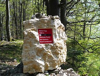
WThe Hinteri Egg is a mountain of the Jura, located south of Reigoldswil in the Swiss canton of Basel-Landschaft, close to the border with the canton of Solothurn.
 W
WLa Barillette is one of the highest points of Canton Vaud's Jura mountains in Switzerland.
 W
WLa Dôle is a mountain of the Jura, overlooking Lake Geneva in the westernmost part of the canton of Vaud. Rising to an altitude of 1677 meters, it is the second highest peak in the Swiss portion of the Jura, after Mont Tendre. Administratively, the summit is split between the municipalities of Gingins, Chéserex and La Rippe. The mountain is also close to and easily accessible from Saint-Cergue and the Col de la Givrine to the north, both above 1000 meters and connected to Nyon on Lake Geneva by road and by the Nyon–St-Cergue–Morez Railway. A paved road also climbs to the Chalet de la Dôle below the summit from Gingins.
 W
WLe Chasseron is a mountain in the Jura Mountains, overlooking Sainte-Croix in the canton of Vaud. It has an elevation of 1,607 metres above sea level and is amongst the most isolated mountains of Switzerland.
 W
WLe Noirmont is a mountain of the Jura, located north of Saint-Cergue in the canton of Vaud. At 1,567 metres, it is the highest mountain between the Col de la Givrine and Mont Tendre. Although Le Noirmont is wholly in Switzerland, the border with France runs on the western base of the mountain.
 W
WLe Reculet is the second-highest peak in the Jura Mountains, with an elevation of 1718 metres. It is located in the Ain department of France. It is a few kilometres south of the Crêt de la Neige on the territory of the town of Thoiry.
 W
WLe Soliat is a mountain of the Jura, overlooking Lake Neuchâtel in western Switzerland. The main summit is located within the canton of Neuchâtel. A secondary summit is located within the canton of Vaud.
 W
WLe Suchet is a mountain of the Jura range, located south of Baulmes in the canton of Vaud.
 W
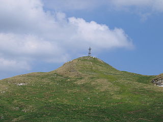
WLes Ordons is a mountain of the Jura, located north-east of the Col des Rangiers in the canton of Jura. It houses the Les Ordons Transmission Tower.
WMont d'Amin is a mountain of the Jura, located east of the Vue des Alpes in the canton of Neuchâtel. It lies on the range between the valleys of Saint-Imier and Val-de-Ruz.
 W
WMont Risoux is a large wooded crest of the Jura Mountains, located between France and Switzerland. The culminating point, lying on the border between the department of Doubs and the canton of Vaud, is named Gros Crêt.
WMontgremay is a mountain of the Jura, located south Cornol in the canton of Jura. It is one of the highest summits of the region of Ajoie.
 W
WThe Moron is a mountain of the Jura, located north of Malleray in the canton of Bern.
 W
WMont Racine is a peak in the Jura Mountains, located between La Sagne and Les Geneveys-sur-Coffrane in the canton of Neuchâtel.
 W
WMont Raimeux is a mountain of the Jura range, located on the border between the Swiss cantons of Jura and Berne. Reaching a height of 1,302 metres above sea level, it is the highest summit in the canton of Jura.
 W
WThe Rocher des Tablettes is a mountain of the Jura, located west of Rochefort in the canton of Neuchâtel. Its south side consists of steep limestone cliffs overlooking the valley of the Areuse.
WThe Ruchen is a mountain of the Jura, located on the border between the Swiss cantons of Basel-Landschaft and Solothurn. It lies between Langenbruck and Eptingen. The Ruchen is the easternmost summit above 1,100 metres in the Jura Mountains. East of the Ruchen is the Belchenflue.
 W
WMont Soleil is a mountain of the Jura Mountains, located north of Saint-Imier in the canton of Bern, Switzerland. The summit reaches to 1,291 metres (4,236 ft) and the area can be easily accessed by a funicular from Saint-Imier, reaching a height of 1,180 m (3,870 ft).
WThe Sommêtres are a chain of rocks overlooking the Doubs, north of Le Noirmont in the canton of Canton of Jura.
 W
WMont Tendre is a mountain of the Jura, located between the valley of Joux and the basin of Lake Geneva in the canton of Vaud. With an elevation of 1,679 metres above sea level, it is the highest summit of the Swiss portion of the Jura Mountains and, therefore, the highest summit of Switzerland outside the Alps. It is also the most isolated mountain of the canton. It is found in the community of Montricher.
 W
WMont Terri is one of the mountains of the Jura Mountains range. It is located south of Cornol in the Canton of Jura. The mountain can be located 140 km west of Zurich.
 W
WThe Tête de Ran is a mountain of the Jura, located south-west of the Vue des Alpes in the canton of Neuchâtel.
WThe Vogelberg is a mountain of the Jura, located north of Mümliswil in the Swiss canton of Solothurn. It lies east of the Passwang Pass. The border with the canton of Basel-Landschaft runs north of the mountain. The Vogelberg is the easternmost summit above 1,200 metres in the Jura Mountains.
WThe Walenmatt is a mountain of the Jura, located on the border between the Swiss cantons of Bern and Solothurn. It lies between Crémines and Welschenrohr.
 W
WThe Wasserflue is a mountain of the Jura, located north of Erlinsbach in the canton of Aargau. It lies on the range east of the Salhöhe Pass.
 W
WThe Weissenstein is a mountain of the Jura, located north of Solothurn in the Swiss canton of Solothurn. The culminating point of the chain is distinguished by the name Röti. It is the easternmost summit above 1,300 metres in the Jura Mountains.
 W
WThe Wisenberg is a wooded mountain of the Jura Mountains, located between Häfelfingen and Wisen in northern Switzerland. The summit lies within the canton of Basel-Landschaft, near the border with the canton of Solothurn. The Wisenberg is both the northernmost and easternmost summit above 1,000 metres in the Jura Mountains.