 W
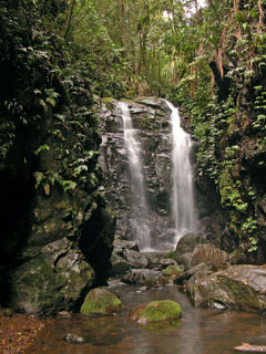
WThe Gondwana Rainforests of Australia, formerly known as the Central Eastern Rainforest Reserves, are the most extensive area of subtropical rainforest in the world. Collectively, the rainforests are a World Heritage Site with fifty separate reserves totalling 366,500 hectares from Newcastle to Brisbane.
 W
WThe Albert River is a perennial river located in the South East region of Queensland, Australia. Its catchment lies within the Gold Coast and Scenic Rim Region local government areas and covers an area of 782 square kilometres (302 sq mi). The river provides potable water for the town of Beaudesert.
 W
WThe Allyn Range is a mountain range in New South Wales, Australia. It is part of the Barrington Tops region and joins the Mount Royal Range on the Barrington Tops plateau to the north. High points on the range include Eremeren Point, Ben Bullen, Mount Gunama, Mount Lumeah and Mount Allyn.
 W
WThe Barrington Tops National Park is a protected national park located in the Hunter Valley, approximately 200 kilometres (120 mi) north of Sydney in New South Wales, Australia. Gazetted in 1969, the 76,512-hectare (189,070-acre) park is situated between Scone, Singleton, Dungog, Gloucester and East Gresford.
 W
WThe Border Ranges National Park is a protected national park that is located in the Northern Rivers region of New South Wales, Australia. A small portion of the national park is also located in South East Queensland. The 31,729-hectare (78,400-acre) park is situated approximately 150 kilometres (93 mi) south of Brisbane, north of Kyogle.
 W
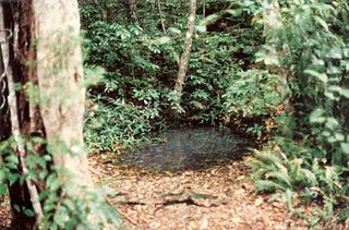
WBurraga Swamp is situated beside Mount Lumeah in the Barrington Tops area in New South Wales, Australia. It is surrounded by Antarctic Beech cool temperate rainforest at an altitude of 985 metres above sea level.
 W
WThe Coomera River is a perennial river located in the South East region of Queensland, Australia. Its catchment lies within the Gold Coast and Scenic Rim Region local government areas and covers an area of 489 square kilometres (189 sq mi).
 W
WCunnawarra is a national park located in New South Wales, Australia, 80 kilometres (50 mi) east of Armidale, 10 kilometres (6.2 mi) off the Waterfall Way and 565 kilometres (351 mi) north of Sydney. The 25-kilometre (16 mi) Styx River Forest Way runs from the Point Lookout Road through Cunnawarra National Park to the Kempsey Road. The New England National Park adjoins the Cunnawarra National Park on the north-eastern boundary and the Oxley Wild Rivers National Park joins it on the southern corner.
 W
WDorrigo National Park is a national park in New South Wales, Australia, 580 kilometres (360 mi) north of Sydney on Dome Road off the Waterfall Way, 5 kilometres (3.1 mi) east of the town of Dorrigo.
 W
WThe Fenwicks Scrub Flora Reserve is a protected nature reserve that is located on the Mid North Coast of New South Wales, Australia. The 110-hectare (270-acre) reserve is situated west of Port Macquarie on the Great Dividing Range. The reserve is dominated by warm temperate rainforest. Rainforest occurs between 990 and 1,100 metres above sea level. The 20 metres (66 ft) tall canopy is 98% Sassafras and Coachwood.
 W
WGibraltar Range is a national park in north-eastern New South Wales, Australia, 79 kilometres (49 mi) north-east of Glen Innes and 493 kilometres (306 mi) north of Sydney. The Park is part of the Washpool and Gibraltar Range area of the World Heritage Site Gondwana Rainforests of Australia inscribed in 1986 and added to the Australian National Heritage List in 2007.
 W
WThe Iluka Nature Reserve in a protected nature reserve that is located in the Northern Rivers region of New South Wales, Australia. The 135-hectare (330-acre) reserve is situated near the coastal town of Iluka.
 W
WThe Lamington National Park is a national park, lying on the Lamington Plateau of the McPherson Range on the Queensland/New South Wales border in Australia. From Southport on the Gold Coast the park is 85 kilometres (53 mi) to the southwest and Brisbane is 110 kilometres (68 mi) north. The 20,600 hectares Lamington National Park is known for its natural environment, rainforests, birdlife, ancient trees, waterfalls, walking tracks and mountain views.
WThe Limpinwood Nature Reserve is a protected nature reserve that is located on the Northern Rivers region of New South Wales, in eastern Australia. The reserve was gazetted in April 1963 with additions made in 1967, over former fauna and crown reserves, and further additions were made in 1988 to make the reserve to its current area of 2,646 hectares. The reserve is situated north-west of the rural locality of Limpinwood, and north of Tyalgum and defines part of the state border between New South Wales and Queensland.
 W
WThe Logan River is a perennial river located in the Scenic Rim, Logan and Gold Coast local government areas of the South East region of Queensland, Australia. The 184-kilometre (114 mi)-long river is one of the dominant waterways in South East Queensland that drains the southern ranges of the Scenic Rim and empties into Moreton Bay after navigating the City of Logan, a major suburban centre located south of Brisbane. The catchment is dominated by urban and agricultural land use. Near the river mouth are mangrove forests and a number of aquaculture farms.
 W
WThe Main Range is a mountain range and national park in Queensland, Australia, located predominantly in Tregony, Southern Downs Region, 85 kilometres (53 mi) southwest of Brisbane. It is part of the World Heritage Site Gondwana Rainforests of Australia. It protects the western part of a semicircle of mountains in South East Queensland known as the Scenic Rim. This includes the largest area of rainforest in South East Queensland. The park is part of the Scenic Rim Important Bird Area, identified as such by BirdLife International because of its importance in the conservation of several species of threatened birds.
 W
WThe Mallanganee National Park is a protected national park located in the Northern Rivers region of New South Wales, Australia. The 1,144-hectare (2,830-acre) park is located approximately 570 kilometres (350 mi) north of Sydney and can be located via Kyogle via the Bruxner Highway and the Summerland Way.
WMebbin is a national park located in New South Wales, Australia, 633 kilometres (393 mi) north of Sydney. It is part of the Shield Volcano Group of the World Heritage Site Gondwana Rainforests of Australia inscribed in 1983 and added to the Australian National Heritage List in 2007. It is also part of the Scenic Rim Important Bird Area, identified as such by BirdLife International because of its importance in the conservation of several species of threatened birds.
 W
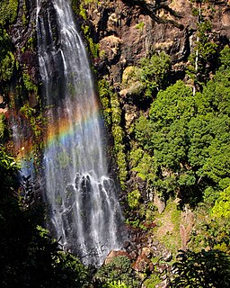
WThe Morans Falls, a plunge waterfall on Morans Creek, is located in the UNESCO World Heritage–listed Gondwana Rainforests in the South East region of Queensland, Australia.
 W
WMount Banda Banda, a mountain of the Mid North Coast region of New South Wales, Australia, is situated 320 kilometres (200 mi) from Sydney within the Willi Willi National Park. Banda Banda can be seen on the north western horizon from Port Macquarie. And seen on the south western horizon 39km from the town of Kempsey. At 1,258 metres (4,127 ft) AHD it is the highest mountain in the region.
 W
WMount Barney National Park is a national park in Queensland (Australia), 90 km southwest of Brisbane. It amalgamated the adjacent Mount Lindesay National Park in 1980. It is part of the Scenic Rim Important Bird Area, identified as such by BirdLife International because of its importance in the conservation of several species of threatened birds.
 W
WMount Cabrebald is a mountain located within the Barrington Tops National Park, in the Upper Hunter region of New South Wales, Australia. With an elevation of 1,017 metres (3,337 ft) above sea level, the mountain is situated 200 kilometres (120 mi) north of Sydney, near Singleton.
 W
WMount Chinghee is a national park in Queensland, Australia, 93 kilometres (58 mi) south of Brisbane. It is part of the Shield Volcano Group of the World Heritage Site Gondwana Rainforests of Australia inscribed in 1986 and added to the Australian National Heritage List in 2007. It is also part of the Scenic Rim Important Bird Area, identified as such by BirdLife International because of its importance in the conservation of several species of threatened birds.
WThe Mount Clunie National Park is a protected national park that is located in the Northern Rivers region of New South Wales, Australia. The 1,426-hectare (3,520-acre) park is situated approximately 631 kilometres (392 mi) north of Sydney and can be located via Kyogle via the Bruxner Highway and the Summerland Way. The park's north-eastern limits define the state border between New South Wales and Queensland.
 W
WThe Mount Hyland Nature Reserve is a protected nature reserve that is located in the New England region of New South Wales, in eastern Australia. The 2,519-hectare (6,220-acre) reserve is situated approximately 35 kilometres (22 mi) west of Dorrigo.
WThe Mount Nothofagus National Park is a protected national park located in the Northern Rivers region of New South Wales, Australia. The 2,180-hectare (5,400-acre) park is located approximately 634 kilometres (394 mi) north of Sydney and can be located via Kyogle via the Bruxner Highway and the Summerland Way.
 W
WThe Mount Royal National Park is a protected national park located in the Hunter region of New South Wales, Australia. Gazetted in 1997, the 6,920-hectare (17,100-acre) park is situated approximately 187 kilometres (116 mi) north of Sydney.
 W
WThe Mount Royal Range is a mountain range in the Hunter region of New South Wales, Australia.
 W
WThe New England National Park is a protected national park located on the Northern Tablelands in the New England region of New South Wales, Australia. The 67,303-hectare (166,310-acre) park was created in May 1935 and is situated approximately 560 kilometres (350 mi) north of Sydney, and 10 kilometres (6.2 mi) south of Waterfall Way, just 85 kilometres (53 mi) east of Armidale and 65 kilometres (40 mi) west of Coffs Harbour. The closest village to New England National Park is Ebor, located 20 kilometres (12 mi) away.
 W
WThe Nightcap National Park is a national park situated within the Nightcap Range in the Northern Rivers region of New South Wales, Australia. The 8,080-hectare (20,000-acre) park was created in April 1983 and is situated 35 kilometres (22 mi) north of Lismore. The national park is classed by the IUCN World Commission on Protected Areas as Category II and is part of the Shield Volcano Group of the World Heritage Site Gondwana Rainforests of Australia inscribed in 1986 and added to the Australian National Heritage List in 2007. The park was severely burned during the 2019-2020 Australian brushfire season, and its biodiversity has likely been decimated.
 W
WNuminbah Nature Reserve is a protected nature reserve that is located in the Northern Rivers region of New South Wales, in eastern Australia. The reserve was gazetted in December 1981 with a further addition made in 1989 to make the reserve to its current area of 858 hectares. The reserve is situated north-east of the rural locality of Numinbah, and south of the Queensland town of Springbrook and defines part of the state border between New South Wales and Queensland.
 W
WThe Oxley Wild Rivers National Park is a protected national park that is located in the Northern Tablelands region of New South Wales, Australia in the Port Macquarie-Hastings City Council and Walcha Shire councils. The 145,223-hectare (358,850-acre) park is situated 445 kilometres (277 mi) north of Sydney and is named in memory of the Australian explorer John Oxley, who passed through the area in 1818 and is one of the largest national parks in New South Wales.
 W
WThe Spicers Gap Road Conservation Park is a protected conservation park located within the Main Range National Park in south east Queensland, Australia. The park is part of the Main Range group World Heritage Site Gondwana Rainforests of Australia inscribed in 1986 and added to the Australian National Heritage List in 2007.
 W
WThe Springbrook National Park is a protected national park that is located in the Gold Coast hinterland of Queensland, Australia. The 6,197-hectare (15,310-acre) park is situated on the McPherson Range, near Springbrook, approximately 100 kilometres (62 mi) south of Brisbane. The park is part of the Shield Volcano Group of the UNESCO World Heritage–listed Gondwana Rainforests of Australia.
 W
WThe Tooloom National Park is a protected national park located in the Northern Rivers region of New South Wales, Australia. The 4,380-hectare (10,800-acre) part is situated approximately 616 kilometres (383 mi) north of Sydney and 20 kilometres (12 mi) from the border town of Urbenville.
 W
WThe Toonumbar National Park is a protected national park located in the Northern Rivers region of New South Wales, Australia. The 14,910-hectare (36,800-acre) park is situated approximately 620 kilometres (390 mi) north of Sydney, near the town of Woodenbong.
 W
WThe Washpool National Park is a protected national park located in the New England region of New South Wales, Australia. The 58,678-hectare (145,000-acre) park is situated approximately 520 kilometres (320 mi) north of Sydney, inland from Grafton. The park has two campgrounds and is managed by the NSW National Parks & Wildlife Service. It was established in 1983 to preserve the significant plant and animal populations found in the Washpool and Gibraltar Range forests.
 W
WThe Werrikimbe National Park is a protected national park located in the catchment zone of the Upper Hastings River in New South Wales, Australia. Gazetted in 1975, the 33,309-hectare (82,310-acre) park is situated approximately 486 kilometres (302 mi) north of Sydney, 65 kilometres (40 mi) north-west of Wauchope, and 90 kilometres (56 mi) east of Walcha on the eastern escarpment of the Great Dividing Range.
 W
WThe Willi Willi National Park is a protected national park located on the North Coast region of New South Wales, Australia. Gazetted in 1996, the 29,870-hectare (73,800-acre) park is situated 325 kilometres (202 mi) northeast of Sydney and 60 kilometres (37 mi) west of Wauchope.
 W
WThe Wilsons Peak Flora Reserve is a protected nature reserve that is located in the Northern Rivers region in the state of New South Wales, in eastern Australia. The reserve is bounded to the north by the border between New South Wales and the state of Queensland. The nearest town is the Queensland settlement of Killarney.
WWollumbin National Park is a national park located in northern New South Wales, Australia, 642 kilometres (399 mi) north of Sydney near the border with the state of Queensland. It surrounds Mount Warning, part of a remnant caldera of a much larger extinct volcano. The park is administered by the NSW National Parks and Wildlife Service. The park is part of the Scenic Rim Important Bird Area, identified as such by BirdLife International because of its importance in the conservation of several species of threatened birds.