 W
WThis is a list of rivers of Thailand. The rivers are arranged alphabetically within their respective provinces or special governed districts. The same river may be found in more than one province as many rivers cross province borders.
 W
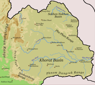
WThailand has 25 river basins with 254 sub-basins. Rainwater is one of the most important sources of water. Thailand's water resoukle per capita is less than that of other countries in the region.
 W
WThe Bang Pakong is a river in east Thailand. The river originates at the confluence of the Phra Prong River and the Hanuman River near Kabin Buri, Prachinburi Province. It empties after 231 kilometres into the Gulf of Thailand at the northeastern tip of the Bay of Bangkok. The watershed of the Bang Pakong is about 17,000 square kilometres (6,600 sq mi). The river powers a power station near its mouth, near Highway 7.
 W
WChanthaburi River, formerly and still colloquially known as Chanthabun River (แม่น้ำจันทบูร) is a river in Thailand, regarded as the main watercourse of Chanthaburi Province.
 W
WThe Chao Phraya is the major river in Thailand, with its low alluvial plain forming the centre of the country. It flows through Bangkok and then into the Gulf of Thailand.
 W
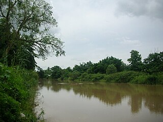
WThe Chi River is the longest river flowing wholly within Thailand. It is 765 kilometres (475 mi) long but carries less water than the second longest river, the Mun. The name of the river is "Mae Si" in the Isan and Lao languages of the region, being transliterated as "Chi" in Bangkok-Thai. In wet seasons there are often flash floods in the floodplain of the Chi River basin.
 W
WLam Dom Noi is a tributary of the Mun River. It originates in the Dongrek mountains and flows northwards. The watercourse passes Buntharik District and is stopped by the Sirindhorn Dam in Chong Mek Subdistrict, Sirindhorn District. It is 150 kilometres (93 mi) long.
 W
WThe Ing River is a tributary of the Mekong River in the northern part of Thailand. It has its source in Doi Luang, Phi Pan Nam Range, in Mae Chai District, Phayao Province. The Ing flows through the plain area of Thoeng District.
 W
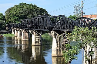
WThe River Kwai, more correctly Khwae Noi or Khwae Sai Yok, is a river in western Thailand. It rises to the east of the Salween in the north-south spine of the Bilauktaung range near, but not over the border with Burma. It begins at the confluence of Ranti, Songkalia and Bikhli Rivers. At Kanchanaburi it merges with the Khwae Yai River to form the Mae Klong River, which empties into the Gulf of Thailand at Samut Songkhram.
 W
WThe Khwae Yai River, also known as the Si Sawat, is a river in western Thailand. It has its source in the Tenasserim Hills and flows for about 380 kilometres (240 mi) through Sangkhla Buri, Si Sawat, and Mueang Districts of Kanchanaburi Province, where it merges with the Khwae Noi to form the Mae Klong River at Pak Phraek. In 1980, the Srinagarind Dam on the Khwae Yai was completed in Si Sawat District of Kanchanaburi Province. It is an embankment dam for river regulation and hydroelectric power generation.
 W
WThe Kok River flows in Southeast Asia.
 W
WThe Krabi River is a river in Southern Thailand. The Krabi river is 5 kilometres long, as it is the main channel within a larger estuary to the Andaman Sea. The other two main channels are the Yuan River to the south and Chi Lat to the west. The 31 km upper stretch of the river are named Khlong Krabi Yai, which originates at the Phanom mountain.
 W
WThe Kraburi River, also Kra or Pak Chan River is the boundary river between Thailand and Myanmar at the Kra Isthmus of the Malay Peninsula. The river has its source in the Tenasserim Hills and flows into the Andaman Sea near the Thai town of Ranong and Kawthaung, Myanmar.
 W
WThe Lao River or Mae Lao River is a river in Chiang Rai Province, Northern Thailand. It is a tributary of the Kok River, with its mouth near Sum Pratu in Mueang Chiang Rai District. This river gives its name to the Mae Lao District.
 W
WThe Loei River is the one of tributaries of the Mekong River. It originates at the western shore of the Phu Luang plateau, at first flowing southwards. Changing to an eastward direction it becomes the boundary between Loei and Phetchabun Province, encircles the Phu Ho mountain and then flows northwards across the town Loei until it and mouths to the Mekong River in Na Sao Subdistrict, Chiang Khan District.
 W
WThe Lopburi River is a tributary of the Chao Phraya River in central Thailand. It splits from the Chao Phraya river at Tambon Bang Phutsa, Singburi. Passing through Tha Wung district and the town of Lopburi, it enters the Chao Phraya together with the Pa Sak River at the town of Ayutthaya. It is about 95 kilometres (59 mi) long.
 W
WThe Mae Klong, sometimes spelled Mae Khlong or Meklong, is a river in western Thailand. The river begins at the confluence of the Khwae Noi and the Khwae Yai River in Kanchanaburi, it passes Ratchaburi Province and empties into the Gulf of Thailand in Samut Songkhram Province.
 W
WThe Mekong, or Mekong River, is a trans-boundary river in East Asia and Southeast Asia. It is the world's twelfth longest river and the seventh longest in Asia. Its estimated length is 4,350 km (2,703 mi), and it drains an area of 795,000 km2 (307,000 sq mi), discharging 475 km3 (114 cu mi) of water annually. From the Tibetan Plateau the river runs through China, Myanmar, Laos, Thailand, Cambodia, and Vietnam. The extreme seasonal variations in flow and the presence of rapids and waterfalls in the Mekong make navigation difficult. Even so, the river is a major trade route between western China and Southeast Asia.
 W
WThe Moei River is a tributary of the Salween River. Unlike most rivers in Thailand, the Moei River flows north in a northwest direction. It originates in Phop Phra District, Tak Province, flowing then from south to north across Mae Sot, Mae Ramat, and Tha Song Yang Districts, finally entering the Salween River within the limits of Sop Moei District of Mae Hong Son Province. The river is 327 kilometres (203 mi) long.
 W
WThe Mun River, sometimes spelled Moon River, is a tributary of the Mekong River. It carries approximately 26 cubic kilometres (6.2 cu mi) of water per year.
 W
WThe Nakhon Nayok River originates in Khao Yai National Park. It flows southwest, passes through Mueang Nakhon Nayok District, Ban Na District, and Ongkharak District of Nakhon Nayok Province. It then empties into the Bang Pakong River in Ban Sang District, Prachinburi Province at Pak Nam Yothaka. The river is 130 kilometres (81 mi) long.
 W
WThe Nan River is a river in Thailand. It is one of the most important tributaries of the Chao Phraya River.
 W
WThe Ngao River is a river of Thailand with its source in the Phi Pan Nam Range. It is a tributary of the Yom River, part of the Chao Phraya River basin.
 W
WThe Noi River is a river in Thailand.
 W
WThe Pa Sak River is a river in central Thailand. The river originates in the Phetchabun Mountains, Dan Sai District, Loei Province, and passes through Phetchabun Province as the backbone of the province. It then passes through the eastern part of Lopburi Province and Saraburi Province, until it joins the Lopburi River northeast of Ayutthaya Island, before it runs into the Chao Phraya River southeast of Ayutthaya near Phet Fortress. It has a length of 513 km (319 mi) and drains a watershed of 16,291 km2 (6,290 sq mi). The annual discharge is 2.4 km3 (0.58 cu mi).
 W
WThe Pai River is a river that originates in the mountains of the Daen Lao Range, Pai District, Mae Hong Son Province, Thailand. The river flows first in a north-south direction and then in an east-west direction down to Mueang Mae Hong Son District and across the Thai/Burmese border. The river tributes the Salween River in Kayah State, Burma. It is 180 kilometres (110 mi) long.
 W
WThe Phetchaburi River is a river in western Thailand. It has its source in the Tenasserim Hills, in the Kaeng Krachan National Park, Kaeng Krachan district and flows through Tha Yang, Ban Lat, Mueang Phetchaburi and mouths into the Bay of Bangkok in Ban Laem district. It is 210 kilometres (130 mi) long, most of which is within the Phetchaburi Province. It is the backbone of this province.
 W
WThe Ping River, along with the Nan River, is one of the two main tributaries of the Chao Phraya River. It originates at Doi Thuai in the Daen Lao Range, in Chiang Dao district, Chiang Mai Province. After passing Chiang Mai, it flows through the provinces of Lamphun, Tak, and Kamphaeng Phet. At the confluence with the Nan River at Nakhon Sawan, it forms the Chao Phraya River.
 W
WThe Ruak River is a right hand tributary of the Mekong. The mouth of the Ruak river is at the Thai-Burma border opposite Laos, a spot known as the "Golden Triangle", a popular tourist destination.
 W
WSai River, formerly known as the River of Lawa, is a river that forms the natural border between Thailand and Myanmar at Tachileik and Mae Sai Districts. Mae Sai town, where the bridge crossing the international border is located, is named after this river. It is a tributary of the Ruak River, itself a tributary of the Mekong.
WThe Sakae Krang River is a tributary of the Chao Phraya River. It originates in Mae Wong National Park, Nakhon Sawan Province. It is 225 kilometres (140 mi) long, with most of its length in Uthai Thani Province. It joins the Chao Phraya River in Uthai Thani city near the Wat Tha Sung.
 W
WThe Salween, known in China as the Nu River, is a river about 2,815 kilometres (1,749 mi) long that flows from the Tibetan Plateau into the Andaman Sea in Southeast Asia.
 W
WSongkalia River Is a river in Kanchanaburi Province That flows together with the other two rivers, the Beak River and the Rantee River at the point called Sam Sop or Sam Phrab at Sangkhlaburi District. Mon Bridge area And Wat Wang Wiwekaram by the word Song Ka Lia in Mon language meaning "over there" is a river that divides the Sangkhlaburi district into two sides.
WThe Songkhram River is a tributary of the Mekong River. It originates in the hills between Nong Han District, Udon Thani Province and Sawang Daen Din District, Sakon Nakhon Province. It flows through Seka District, Wanon Niwat, and Si Songkhram District and empties into the Mekong River in tambon Chai Buri, Tha Uthen District, Nakhon Phanom Province. It is 420 kilometres (260 mi) long.
 W
WThe Taeng River or Mae Taeng River is a tributary of the Ping River, one of the two main contributories of the Chao Phraya River. It originates in the Daen Lao Range in Wiang Haeng District, Chiang Mai Province, Thailand, very near to the border with Burma. It then flows through Chiang Dao District and Mae Taeng District, separating the Thanon Thong Chai Range from the Daen Lao Range, into the Ping River. It is a popular river for white water rafting due to the existence of many grade 3-5 rapids.
 W
WThe Tapi river is the longest river in southern Thailand. The river originates at Khao Luang mountain in Nakhon Si Thammarat Province, and empties into the Gulf of Thailand at Bandon Bay near the town of Surat Thani. It has a length of 230 kilometres (140 mi).
 W
WThe Tha Chin river is a distributary of the Chao Phraya river, Thailand. It splits near the province of Chai Nat and then flows west from the Chao Phraya through the central plains, until it empties into the Gulf of Thailand in Samut Sakhon Province.
 W
WThe Wang River is a river in northern Thailand.
 W
WThe Wang Thong River is a river in Thailand. Its source lies in the Phetchabun Mountains in the Khao Kho District, Thailand. It flows through Thung Salaeng Luang National Park and forms Namtok Sri Dit and Namtok Kaeng Sopha in the Wang Thong District of Phitsanulok Province, and finally flows through into the Bang Krathum District, passing through Ban Sam Ruen and on to the border of Phitsanulok and Phichit, where it drains into the Nan River at 16°31′06″N 100°19′36″E. The land drained by the Wang Thong River is part of the Nan Basin and the Chao Phraya Watershed.
 W
WThe Yom River is a river in Thailand. It is the main tributary of the Nan River. The Yom River has its source in the Phi Pan Nam Range in Pong District, Phayao Province. Leaving Phayao, it flows through Phrae and Sukhothai as the main water resource of both provinces before it joins the Nan River at Chum Saeng District, Nakhon Sawan Province.
 W
WThe Yuam River (Thai: แม่น้ำยวม is a river in northwestern Thailand, part of the Salween watershed. It originates in the mountains of the Thanon Thong Chai Range, Khun Yuam District, Mae Hong Son Province, Thailand. The river flows in a north–south direction and then in Sop Moei District it bends westwards and then northwestwards, forming a stretch of the Thai/Burmese border shortly before it joins the left bank of the Moei River, shortly before its confluence with the Salween.