 W
WThe Tongass National Forest in Southeast Alaska is the largest national forest in the United States at 16.7 million acres. Most of its area is temperate rain forest, and is remote enough to be home to many species of endangered and rare flora and fauna. The Tongass, which is managed by the United States Forest Service, encompasses islands of the Alexander Archipelago, fjords and glaciers, and peaks of the Coast Mountains. An international border with Canada runs along the crest of the Boundary Ranges of the Coast Mountains. The forest is administered from Forest Service offices in Ketchikan. There are local ranger district offices located in Craig, Hoonah, Juneau, Ketchikan, Petersburg, Sitka, Thorne Bay, Wrangell, and Yakutat.
 W
WAdmiralty Island National Monument is a United States National Monument located on Admiralty Island in Southeast Alaska, and is managed as part of the Tongass National Forest. It was created December 1, 1978, and covers 955,747 acres (3,868 km2) in Southeast Alaska. The remoteness of the monument led Congress to pass legislation designating all but 18,351 acres (74 km2) of the monument as the Kootznoowoo Wilderness, ensuring that the vast bulk of this monument is permanently protected from development. The monument is administered by the U.S. Forest Service from offices in Juneau.
 W
WAlaska Airlines Flight 1866 was a regularly scheduled passenger flight operated by Alaska Airlines from Anchorage, Alaska, to Seattle, Washington, with several intermediate stops in southeast Alaska. On September 4, 1971, the aircraft operating the flight crashed into a mountain in Haines Borough, about 18 miles west of Juneau, Alaska while on approach for landing. All 111 people aboard were killed. It was the first fatal jet aircraft crash involving Alaska Airlines, and remained the deadliest single-aircraft accident in United States history until June 24, 1975, when Eastern Air Lines Flight 66 crashed.
 W
WThe Alexander Archipelago is a 300-mile (480 km) long archipelago, or group of islands, of North America off the southeastern coast of Alaska. It contains about 1,100 islands, which are the tops of the submerged coastal mountains that rise steeply from the Pacific Ocean. Deep channels and fjords separate the islands and cut them off from the mainland. The northern part of the Inside Passage is sheltered by the islands as it winds its way among them.
 W
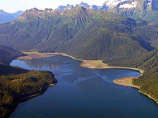
WThe Alexander Lake Shelter Cabin is a historic backcountry shelter in the Admiralty Island National Monument. It is located at the eastern tip of Lake Alexander, on the Admiralty Island Canoe Route. The cabin is a three-sided Adirondack log shelter made of peeled logs covered with wood shakes. It was constructed by a Civilian Conservation Corps crew in 1935, and received maintenance from the United States Forest Service as recently as 1980.
 W
WBay of Pillars is a bay located in the Alexander Archipelago in the southeastern region of the U.S. state of Alaska. It is situated within the Kuiu Wilderness of the Tongass National Forest.
WThe Beaver Lake Dam, in Admiralty Island National Monument near Angoon, Alaska, is a Civilian Conservation Corps-built structure that was built in 1936. It was listed on the National Register of Historic Places in 1995.
 W
WThe Big Shaheen Cabin, in the Admiralty Island National Monument near Angoon, Alaska, is a historic log cabin that was built by the Civilian Conservation Corps in 1935. It was listed on the National Register of Historic Places in 1995; the listing included the cabin and three other contributing structures.
 W
WChichagof Island, or Shee Kaax, is an island in the Alexander Archipelago of the Alaska Panhandle. At 75 miles (121 km) long and 50 miles (80 km) wide, it has a land area of 2,048.61 square miles (5,305.9 km2), making it the fifth largest island in the United States and the 109th largest island in the world. Its coastline measures 742 miles. There was a 2000 census population of 1,342 persons. It is one of the ABC islands of Alaska. Chichagof Island has the highest population of bears per square mile of any place on Earth.
WThe Davidson Lake Shelter Cabin is a historic three-sided log shelter located near Davidson Lake in the Admiralty Island National Monument. The structure was built in the 1930s by a crew of the Civilian Conservation Corps, a Great Depression-era works project of the United States government. The basic superstructure of the shelter is made of peeled logs, and the roof and walls are composed of wooden shakes. It is one of a series of CCC-built shelters along the Admiralty Island Canoe Route.
 W
WDeer Mountain is a 3,001.97 feet (915.00 m) mountain peak located in the Tongass National Forest in the Ketchikan Gateway Borough, Alaska, which dominates the skyline behind downtown Ketchikan. The Deer Mountain National Recreation Trail provides a strenuous hiking route to the summit, passing through temperate rainforests, muskeg and alpine meadows as it gains 2,600 feet (790 m) of elevation over 2.75 miles (4.43 km) from the trailhead in Ketchikan to the peak.
 W
WThe Distin Lake Shelter Cabin is a historic backcountry shelter in the Admiralty Island National Monument. It is located on the northwest shore of Distin Lake, on the Admiralty Island Canoe Route. The cabin, originally a three-sided Adirondack log shelter, was constructed by a Civilian Conservation Corps crew in 1932. In 1960, a fourth wall, wooden floor, and bunk beds were added to the structure. There is a window, and the front door is one recycled from a theater; it is labeled "Balcony" on the inside.
 W
WThe Etolin Canoe is an unfinished dugout canoe on Etolin Island, in the Tongass National Forest, that is listed on the U.S. National Register of Historic Places. It is made of a single Western red cedar or an Alaska yellow cedar trunk and was started, it is believed, somewhere between 1880 and 1920.
WThe Hasselborg Cabin, also known as the Hasselborg Creek Cabin, is a backcountry shelter in the Admiralty Island National Monument, part of Tongass National Forest in Southeast Alaska. It is one of a number of such facilities built by Civilian Conservation Corps (CCC) on the Admiralty Island Canoe Route between 1933 and 1937. As built by the CCC, it was a three-sided Adirondack-style log shelter, timber-framed, and measuring about 12'6" by 10'6". It is one of only two cabins built on the route that has a fireplace; it is built of brick and stone. It is also distinctive for its floor, which is concrete slab, where most other cabins originally had dirt floors. Its roof was originally wood shakes, but is now corrugated metal. The front has subsequently been enclosed.
WThe Hasselborg Lake East Shelter Cabin was a historic backcountry shelter in the Admiralty Island National Monument, part of Tongass National Forest in Southeast Alaska. The cabin, of which at best ruins survive today, was a three-sided Adirondack-style log structure, made of peeled logs, and covered with wood shakes. It was located near the mouth of the stream that drains Beaver Lake into Hasselborg Lake. The shelter was built in 1936 as part of a Civilian Conservation Corps works project to create a canoe route across the island.
WThe Hasselborg Lake North Shelter Cabin is a historic backcountry shelter in the Admiralty Island National Monument, part of Tongass National Forest in Southeast Alaska. The three-sided Adirondack-style log cabin, of which at best ruins survive today, was built in 1935 by a Civilian Conservation Corps work crew as part of a canoe route across the island. It is located at the northeast corner of Hasselborg Lake, where a poorly maintained or abandoned trail leads north to Windfall Harbor.
WThe Hasselborg Lake South Shelter Cabin is a historic backcountry shelter in the Admiralty Island National Monument, part of the Tongass National Forest in Southeast Alaska. It is one of a number of such facilities built by Civilian Conservation Corps (CCC) on the Admiralty Island Canoe Route between 1933 and 1937. The cabin is located on the southwest of Hasselborg Lake, north of the Hasselborg Cabin, and near the portage trail leading to Lake Guerin. As built by the CCC, it was a three-sided Adirondack-style log shelter with shake walls and roof. Sills and the lower ends of its posts have been replaced due to rot.
 W
WThe Juneau Icefield is an ice field located just north of Juneau, Alaska, continuing north through the border with British Columbia, extending through an area of 3,900 square kilometres (1,500 sq mi) in the Coast Range ranging 140 km (87 mi) north to south and 75 km (47 mi) east to west. The icefield is the source of many glaciers including the Mendenhall Glacier and the Taku Glacier. The icefield is home to over 40 large valley glaciers and 100 smaller ones. The Icefield serves as a tourist attraction with many travellers flown in by helicopter for quick walks on the 240-to-1,400-metre deep ice and the massive, awe-inspiring moist crevasses. The icefield, like many of its glaciers, reached its maximum glaciation point around 1700 and has been in retreat since. In fact, of the icefield's 19 notable glaciers, the Taku Glacier is the only one presently advancing. Much of the icefield is contained within the Tongass National Forest. Since 1948, the Juneau Icefield Research Program has monitored glaciers of the Juneau Icefield. On the west side of the icefield, from 1946-2009, the terminus of the Mendenhall Glacier has retreated over 700 metres (0.43 mi).
 W
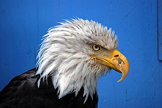
WThe Juneau Raptor Center (JRC) is a raptor rehabilitation center in Juneau in the U.S. state of Alaska. Founded in 1987 and located in the Tongass National Forest, its mission is the rehabilitation of sick and injured eagles, hawks, falcons, owls, ravens, hummingbirds and other avian wildlife brought in from Juneau and Southeast Alaska. The JRC is licensed by the US Fish and Wildlife Service to handle eagles and migratory birds, and is governed in part by the Bald and Golden Eagle Protection Actand the Migratory Bird Treaty Act of 1918.
 W
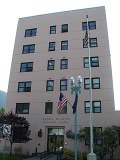
WThe Ketchikan Federal Building is a courthouse of the United States District Court for the District of Alaska, located at 648 Mission Street in Ketchikan, Alaska. It was completed in 1938, and was listed on the National Register of Historic Places on April 28, 2006. The building's primary tenant is the United States Forest Service Tongass National Forest Supervisor's Office, which occupies space on the first, second, third, fourth and sixth floors. The fifth floor houses a courtroom and related support offices, while the first floor also houses an office of the United States Customs and Border Protection.
 W
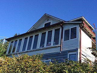
WThe Ketchikan Ranger House at 309 Gorge Street in Ketchikan, Alaska was built in 1916 in the residential Captain's Hill district of Ketchikan. Designed by USDA Forest Service in "Vernacular Victorian" style, it housed the U.S. Forest Service's district rangers until 1978. The 1-1/2 story frame house has remained essentially unaltered from its original construction. It was built for $650 to serve the first forest ranger for the state of Alaska.
WKinky Island is an island in the Alexander Archipelago of the Alaska Panhandle.
WThe Lake Guerin East Shelter Cabin is a historic backcountry shelter in the Admiralty Island National Monument, part of the Tongass National Forest in Southeast Alaska. It is one of a number of such facilities built by Civilian Conservation Corps (CCC) on the Admiralty Island Canoe Route between 1933 and 1937. This cabin, a three-sided Adirondack-style log structure with shake walls and roof, was built in 1935. As reported in 1995, only remnants of the cabin remain at the east of Lake Guerin, near a portage trail leading to Hasselborg Lake.
WThe Lake Guerin Shelter Lookout/Cabin, historically the Lake Guerin West Shelter Cabin is a historic backcountry shelter in the Admiralty Island National Monument, part of the Tongass National Forest in Southeast Alaska. It is one of a number of such facilities built by Civilian Conservation Corps (CCC) on the Admiralty Island Canoe Route between 1933 and 1937. This cabin, a three-sided Adirondack-style log structure with shake walls and roof, was built in 1936. The cabin continues to be maintained by the Forest Service.
 W
WMendenhall Glacier is a glacier about 13.6 miles (21.9 km) long located in Mendenhall Valley, about 12 miles (19 km) from downtown Juneau in the southeast area of the U.S. state of Alaska. The glacier and surrounding landscape is protected as part of the 5,815 acres (2,353 ha) Mendenhall Glacier Recreation Area, a federally designated unit of the Tongass National Forest.
WMendenhall Glacier is a glacier about 13.6 miles (21.9 km) long located in Mendenhall Valley, about 12 miles (19 km) from downtown Juneau in the southeast area of the U.S. state of Alaska. The glacier and surrounding landscape is protected as part of the 5,815 acres (2,353 ha) Mendenhall Glacier Recreation Area, a federally designated unit of the Tongass National Forest.
 W
WMisty Fjords National Monument is a national monument and wilderness area administered by the U.S. Forest Service as part of the Tongass National Forest. Misty Fiords is about 40 miles (64 km) east of Ketchikan, Alaska, along the Inside Passage coast in extreme southeastern Alaska, comprising 2,294,343 acres (928,488 ha) of Tongass National Forest in Alaska's Panhandle. All but 151,832 acres (61,444 ha) are designated as wilderness.
WThe Mitchell Bay Shelter Lookout/Cabin is a historic backcountry shelter in the Admiralty Island National Monument, part of the Tongass National Forest in Southeast Alaska. It is one of a number of such facilities built by Civilian Conservation Corps (CCC) on the Admiralty Island Canoe Route between 1933 and 1937. This cabin, a three-sided Adirondack-style log structure with shake walls and roof, was built in 1936. The cabin, situated overlooking a tidal flat near the head of Mitchell Bay on the west side of the island, continues to be maintained by the Forest Service.
 W
WMitkof Island is an island in the Alexander Archipelago in southeast Alaska between Kupreanof Island to the west and the Alaskan mainland to the east. It is approximately 16 km (9.9 mi) wide and 28 km (17 mi) long with a land area of 539.7 km2 (208.4 sq mi), making it the 30th largest island in the United States. Much of the island is managed as part of the Tongass National Forest.
WThe Mole Harbor Shelter Lookout/Cabin is a historic backcountry shelter in the Admiralty Island National Monument, part of the Tongass National Forest in Southeast Alaska. It is one of a number of such facilities built by Civilian Conservation Corps (CCC) on the Admiralty Island Canoe Route between 1933 and 1937. This cabin, a three-sided Adirondack-style log structure with shake walls and roof, was built in 1936. The cabin, situated overlooking a tidal flat near the head of Mole Harbor on the east side of the island, continues to be maintained by the Forest Service. It is accessible via water, or by a trail from Lake Alexander.
WNew Russia was a maritime fur trading post and penal colony established by Russians in 1796 in what is now Yakutat Borough, Alaska. It was presumably named after the Joseph Billings ship Slava Rossii, or "Glory of Russia". The post was attacked and destroyed by Tlingits in 1805. It consisted of 7 buildings inside a stockade, and 5 buildings outside. The buildings were burnt in 1805, and the site was never again occupied. The events at New Russia represent a pivotal moment in Russian-Tlingit relations. As an archaeological site, it was declared a National Historic Landmark in 1978.
 W
WPennock Island is located in the U.S. state of Alaska near the city of Ketchikan. The island is situated within the Ketchikan Gateway Borough and is part of the Alexander Archipelago. Most of the island is public land managed by the Tongass National Forest.
 W
WThe Stikine-LeConte Wilderness is on the mainland of southeast Alaska, southeast of Petersburg and north of Wrangell, Alaska. The boundary extends from Frederick Sound on the west to the Alaska–Canada boundary on the east. The wilderness is 448,841 acres (181,640 ha) in size. It is part of Tongass National Forest, which is managed by the United States Forest Service.
 W
WTaku Glacier is a tidewater glacier located in Taku Inlet in the U.S. state of Alaska, just southeast of the city of Juneau. Recognized as the deepest and thickest alpine temperate glacier known in the world, the Taku Glacier is measured at 4,845 feet (1,477 m) thick. It is about 58 kilometres (36 mi) long, and is largely within the Tongass National Forest.
WThe Thayer Lake East Shelter Cabin is the ruined remains of a historic backcountry shelter in the Admiralty Island National Monument, part of the Tongass National Forest in Southeast Alaska. It was one of a number of such facilities built by Civilian Conservation Corps (CCC) on the Admiralty Island Canoe Route between 1933 and 1937. This cabin, a three-sided Adirondack-style log structure with shake walls and roof, was built in 1936, and located on the lake near the portage trail connecting to Distin Lake. Unlike other cabins built by the CCC on the island, which were of post-and-beam construction, in this one the logs were saddle-notched together at the corners.
WThe Thayer Lake North Shelter Cabin is a historic backcountry shelter in the Admiralty Island National Monument, part of the Tongass National Forest in Southeast Alaska. It was one of a number of such facilities built by Civilian Conservation Corps (CCC) on the Admiralty Island Canoe Route between 1933 and 1937. This cabin, a three-sided Adirondack-style log structure with shake walls and roof, was built in 1935, and located at the northern tip of Thayer Lake, near a trailhead and a small log bridge.
WThe Thayer Lake South Shelter Cabin is a historic backcountry shelter in the Admiralty Island National Monument, part of the Tongass National Forest in Southeast Alaska. It was one of a number of such facilities built by Civilian Conservation Corps (CCC) on the Admiralty Island Canoe Route between 1933 and 1937. This cabin, a three-sided Adirondack-style log structure with shake walls and roof, was built in 1935, and is located near the southern tip of Thayer Lake, facing a reedy stream blocked by a beaver dam. A portage trail runs nearby.
 W
WThe Tongass Timber Reform Act (TTRA) is an act that was intended to amend the Alaska National Interest Lands Conservation Act (ANILCA), with the primary intention to increase the protection of the Tongass National Forest from logging. The TTRA was introduced on February 9, 1989 at the 101st Congress, 1989-1990, and was enacted when signed by President George H. W. Bush on November 28, 1990. as law. Refer to the GovTrack.us website for the extended text of the bill. For a bill to become law in the United States it must be approved by both the House and the Senate, and signed by the President, who can veto the bill if they chose to. In response to required adjustments to the initial bill, a conference committee was formed, consisting of members from both the House and the Senate, tasked to produce a conference report on the necessary revisions and changes. This revised version of the bill was passed by both the Senate, with a vote of 99-0, and was approved by the House. The sponsor for this bill was a representative from New York's 3rd congressional district, Robert Mrazek (Democrat).
 W
WThe Tree Point Light is a lighthouse located adjacent to Revillagigedo Channel in Southeast Alaska, United States. It is located near the southernmost point of mainland Alaska.
WThe Windfall Harbor Shelter Cabin is a historic backcountry shelter in the Admiralty Island National Monument, part of the Tongass National Forest in Southeast Alaska. It was one of a number of such facilities built by Civilian Conservation Corps (CCC) on the Admiralty Island Canoe Route between 1933 and 1937. This cabin, a three-sided Adirondack-style log structure with shake walls and roof, is located near the southern end of Windfall Harbor, an inlet on the east side of Admiralty Island. The shelter underwent repairs in 1986. The Forest Service is in 2014 in the planning phases of a project to relocate the cabin a short distance to move it away from a major bear travel path.
WYakobi Island is an island in the Alexander Archipelago of southeastern Alaska, United States. It lies to the south of Cross Sound and just off the western edge of Chichagof Island, separated from it by Lisianski Inlet and Lisianski Strait. The island has a land area of 82.37 sq mi (213.3 km²) and no permanent resident population.