 W
WThe Au Sable River in Michigan, United States runs approximately 138 miles (222 km) through the northern Lower Peninsula, through the towns of Grayling and Mio, and enters Lake Huron at the town of Oscoda. It is considered one of the best brown trout fisheries east of the Rockies and has been designated a blue ribbon trout stream by the Michigan Department of Natural Resources. In French, au sable literally means "at the sand." A 1795 map calls it the Beauais River.
 W
WThe Ausable River is a river in southwestern Ontario Canada which empties into Lake Huron at Port Franks, Ontario. The Ausable's initial source is in a moraine near the community of Staffa, Ontario located in the municipality of West Perth, Ontario at a point 334 metres (1,096 ft) above sea level. Although the river has a total measured length of over 240 kilometres (150 mi), because of its meandering course, the mouth in actuality is only 64 kilometres (40 mi) from its source near Staffa. The Ausable drains 1,142 square kilometers (441 sq mi) of land, and falls 158 metres (518 ft) in elevation from source to outlet.
 W
WThe Bad River is a 44.3-mile-long (71.3 km) river in Michigan. It rises in Newark Township near the city of Ithaca in Gratiot County and flows in a north-easterly direction into Saginaw County, and through the village of St. Charles, before emptying into the Shiawassee River within the bounds of the Shiawassee National Wildlife Refuge.
 W
WThe Bayfield River is a river in Huron and Perth Counties in southwestern Ontario, Canada, that empties into Lake Huron at the community of Bayfield in the municipality of Bluewater.
 W
WBlack River is a 78.8-mile-long (126.8 km) river in the U.S. state of Michigan, flowing mostly northward through four Northern Michigan counties: Otsego, Montmorency, Presque Isle, and Cheboygan. The Black River flows into the Cheboygan River at 45°36′13″N 84°27′47″W, just south of the city of Cheboygan, and then into Lake Huron. The main branch of the Black River rises in Charlton Township in east-central Otsego County near the boundary with Montmorency County. The East Branch of the Black River rises less than a mile to the east in Vienna Township in Montmorency County. The other major tributaries, Canada Creek, Tomahawk Creek and the Rainy River all rise in northern Montmorency County.
 W
WThe Blind River is a river in the municipality of Blind River, Algoma District in Northeastern Ontario, Canada. The river is in the Great Lakes Basin and is tributary of Lake Huron.
 W
WBlue Jay Creek is a river on Manitoulin Island in Central Manitoulin and Tehkummah townships, Manitoulin District in northeastern Ontario, Canada and a tributary of Lake Huron.
 W
WBurt Lake is a 17,120 acre (69 km²) lake in Cheboygan County in the U.S. state of Michigan. The western shore of the lake is on the boundary with Emmet County. The lake is named after William Austin Burt, who, together with John Mullett, made a federal survey of the area from 1840 to 1843.
 W
WThe Cass River is a 61.5-mile-long (99.0 km) river in the Thumb region of the U.S. state of Michigan. It drains large portions of Sanilac and Tuscola counties and smaller portions of Genesee, Huron, Lapeer, and Saginaw counties.
 W
WThe Cedar River is a 29.0-mile-long (46.7 km) river in the U.S. state of Michigan, flowing through Clare County and Gladwin County.
 W
WThe Charlotte River is a tributary of the St. Marys River in the state of Michigan in the United States. The stream is 17.1 miles (27.5 km) long and drains an area of 58.4 square miles (151 km2) on the eastern Upper Peninsula. Via the St. Marys River, it is part of the watershed of Lake Huron. Via Lake Huron and the Great Lakes system, it is part of the larger watershed of the St. Lawrence River.
 W
WThe Cheboygan River is a short but significant river in the Lake Huron drainage basin of the U.S. state of Michigan.
 W
WThe Chippewa River is a stream in Michigan, United States, that runs 91.8 miles (147.7 km) through the central Lower Peninsula. The Chippewa is a tributary of the Tittabawassee River and is thus part of the Saginaw River drainage basin. The river is named after the Chippewa people.
 W
WCow Creek is a watercourse in Sarnia Township, Ontario, that empties into Lake Huron. The boundaries of the present day watercourse is confused, due to 19th century efforts to drain a wetland, known as Lake Wawanosh. Lake Wawanosh was drained by Riviere Aux Perches, Perch Creek, a tributary of Cow Creek. In 1859 a short drainage canal was excavated, that has gone by different names, but which has now widely usurped the name Perch Creek.
 W
WThe Flint River is a 78.3-mile-long (126.0 km) river in the Flint/Tri-Cities region of Michigan in the United States. The river's headwaters are in Columbiaville in Lapeer County and flows through the counties of Lapeer, Genesee, and Saginaw. The cities of Lapeer, Flint, Flushing, and Montrose are along its course.
 W
WIndian River in the Lower Peninsula of Michigan is a 3.9-mile-long (6.3 km) waterway in Cheboygan County that flows from Burt Lake at 45°24′37″N 84°37′19″W to Mullett Lake at 45°27′05″N 84°34′39″W. The unincorporated community of Indian River is named after the river.
 W
WThe Kagawong River is a river on Manitoulin Island in Manitoulin District, Ontario, Canada which flows from Lake Kagawong to empty into Mudge Bay on the North Channel Lake Huron. The river falls over a limestone bluff at Bridal Veil Falls. "Kagawong" means "mists rising from falling water" in the Ojibwe language.
 W
WThe Ocqueoc River is stream in Presque Isle County in the northeastern part of the lower peninsula in the U.S. state of Michigan. It is 34.2 miles (55.0 km) long and encompasses a watershed of approximately 94,394 acres (382.00 km2).
WThe Maitland River is a river in Huron County, Perth County and Wellington County in Southwestern Ontario, Canada. The river is in the Great Lakes Basin and empties into Lake Huron at the town of Goderich. It is 150 kilometres (93 mi) long, and is named after Sir Peregrine Maitland, Lieutenant-Governor of Upper Canada from 1818 to 1828. It was formerly known as the Menesetung River.
 W
WThe Manitou River is a river of the Manitoulin Island, flowing in the township of Central Manitoulin and Tehkummah, in Manitoulin District, in Northern Ontario region, in the province of Ontario, Canada.
 W
WThe Mindemoya River is a river on Manitoulin Island in Ontario, Canada, which flows about 5 kilometres (3.1 mi) from Lake Mindemoya to empty into Providence Bay on Lake Huron. There is a boardwalk and large sandy beach at the mouth of the river. "Mindemoya" comes from the Ojibwe word mindimooyenh, which means "old woman". The river is accessible by both boat and foot at a number of points and is often fished for salmon and trout.
 W
WThe Mississagi River is a river in Algoma and Sudbury Districts, Ontario, Canada, that originates in Sudbury District and flows 266 kilometres (165 mi) to Lake Huron at Blind River, Algoma District.
 W
WMisteguay Creek is a tributary of the Flint River, 38.4 miles (61.8 km) long, on the central Lower Peninsula of Michigan in the United States. The stream drains an area of 174.4 square miles (452 km2) in predominantly agricultural areas of the Flint/Tri-Cities region. Via the Flint and Shiawassee rivers, it is part of the watershed of the Saginaw River, which flows to Saginaw Bay of Lake Huron. Via Lake Huron and the Great Lakes system, it is part of the larger watershed of the St. Lawrence River.
 W
WMullett Lake is a lake in Cheboygan County in the U.S. state of Michigan. The lake is named after John Mullett, who, together with William A. Burt, made a federal survey of the area from 1840 to 1843. A neighboring lake was named after Burt. Historically, Mullett Lake has been recorded as Mullet Lake, Mullet's Lake, and Mullett's Lake on maps and documents.
WThe Ocqueoc River is stream in Presque Isle County in the northeastern part of the lower peninsula in the U.S. state of Michigan. It is 34.2 miles (55.0 km) long and encompasses a watershed of approximately 94,394 acres (382.00 km2).
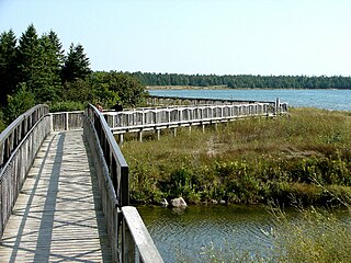
WThe Penetangore River is a river in Kincardine, Bruce County in Southwestern Ontario, Canada. It is in the Great Lakes Basin and empties into Lake Huron. A boardwalk, a harbour, and the Kincardine lighthouse are located on the bank of this river near its mouth.
 W
WThe Pinconning River is a small river on the central Lower Peninsula of Michigan in the United States. It is 15.6 miles (25.1 km) long and flows to Saginaw Bay of Lake Huron, draining an area of 26.6 square miles (69 km2). Via Lake Huron and the Great Lakes system, it is part of the larger watershed of the St. Lawrence River.
 W
WThe Pine River is a 103-mile-long (166 km) river in the Lower Peninsula of the U.S. state of Michigan. The Pine River is a tributary of the Chippewa River and is thus part of the Saginaw River drainage basin.
 W
WThe Pinnebog River is a 39.4-mile-long (63.4 km) river in the Thumb region of the U.S. state of Michigan. The river flows into Lake Huron on the west side of the "tip" of the "thumb".
 W
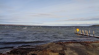
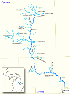
WRifle River is a 60.3-mile-long (97.0 km) river in the U.S. state of Michigan. It rises in northeastern Ogemaw County and flows through Arenac County to enter Saginaw Bay of Lake Huron. Once a logging river during the Michigan forestry boom at the turn of the 20th century, the river is now primarily used for recreation, and is a state-designated natural river. It is a popular river for canoeing, with no portages or dams and an average depth of 18 inches, to 5 feet in downtown Omer. It is also known for having one of the best White Sucker runs in the state of Michigan, in the spring.
 W
WThe Saganing River, also known as Saganing Creek, is a 10.0-mile-long (16.1 km) stream in the U.S. state of Michigan.
WThe Saginaw River is a 22.4-mile-long (36.0 km) river in the U.S. state of Michigan. It is formed by the confluence of the Tittabawassee and Shiawassee rivers southwest of Saginaw. It flows northward into the Saginaw Bay of Lake Huron, passing through the city of Saginaw and Bay City, both of which developed around it in the 19th century. The watershed area is 8,595 square miles (22,260 km2).
WThe Sauble River is a river in Bruce County and Grey County in southwestern Ontario, Canada that flows from its headwaters in the township of Chatsworth to Lake Huron at the community of Sauble Beach.
 W
WThe Saugeen River is located in southern Ontario, Canada. The river begins in the Osprey Wetland Conservation Lands and flows generally north-west about 160 kilometres (99 mi) before exiting into Lake Huron. The river is navigable for some distance, and was once an important barge route. Today the river is best known for its fishing and as a canoe route.
 W
WThe Shiawassee River in the U.S. state of Michigan drains an area of 1,201 square miles (3,110 km2) within Oakland, Genesee, Livingston, Shiawassee, Midland and Saginaw counties. It flows in a generally northerly direction for about 110 miles (180 km) from its source to its confluence with the Tittabawassee River creating the Saginaw River, which drains into the Saginaw Bay of Lake Huron.
 W
WThe Spanish River is a river in Algoma District, Sudbury District and Greater Sudbury in Northwestern Ontario, Canada. It flows 338 kilometres (210 mi) in a southerly direction from its headwaters at Spanish Lake and Duke Lake to its mouth at the North Channel on Georgian Bay, Lake Huron just outside the community of Spanish.
 W
WThe St. Marys River, sometimes written as the St. Mary's River, drains Lake Superior, starting at the end of Whitefish Bay and flowing 74.5 miles (119.9 km) southeast into Lake Huron, with a fall of 23 feet (7.0 m). For its entire length it is an international border, separating Michigan in the United States from Ontario, Canada.
 W
WSturgeon River is a 40.8-mile-long (65.7 km) river in the U.S. state of Michigan, flowing mostly northward through Otsego and Cheboygan counties.
WThe Tittabawassee River flows in a generally southeasterly direction through the Lower Peninsula of the U.S. state of Michigan. The river begins at Secord Lake in Clement Township, at the confluence of the East Branch and the Middle Branch. From there it flows through Gladwin, Midland and Saginaw counties where, as a major tributary of the Saginaw River, it flows into it at Saginaw. Its tributaries include the Chippewa, Pine, Molasses, Sugar, and Tobacco rivers.
 W
WThe Trout River is an 8.5-mile-long (13.7 km) river in Presque Isle County, Michigan, in the United States. It flows into Lake Huron at Rogers City.
 W
WThe Whitefish River is a river in Sudbury District in northeastern Ontario, Canada and a tributary of Lake Huron.