 W
WEllesmere Island is part of the Qikiqtaaluk Region in the Canadian territory of Nunavut. Lying within the Arctic Archipelago, it is considered part of the Queen Elizabeth Islands, with Cape Columbia being the most northerly point of land in Canada.. It comprises an area of 196,235 km2 (75,767 sq mi) and the total length of the island is 830 km (520 mi), making it the world's tenth largest island and Canada's third largest island. The Arctic Cordillera mountain system covers much of Ellesmere Island, making it the most mountainous in the Arctic Archipelago. The Arctic willow is the only woody species to grow on Ellesmere Island.
 W
WThe Agassiz Ice Cap formerly Agassiz Glacier is an ice cap on the central eastern side of Ellesmere Island, Nunavut, Canada. The Agassiz ice cap is about 21,000 km2 (8,100 sq mi) in area. It is located between the North Ellesmere ice field to the north and the Prince of Wales Icefield to the south.
 W
WAlert Airport is located at Alert, Nunavut, Canada, approximately 830 km (520 mi) south of the true North Pole. It is operated by the Canadian Department of National Defence and is part of Canadian Forces Station Alert. A weather station was established on the site in 1950, and in 1957 construction began on the military facilities which are still in use to this day. It is the northernmost airport in the world.
 W
WAlert, in the Qikiqtaaluk Region, Nunavut, Canada, is the northernmost permanently inhabited place in the world, located on Ellesmere Island at latitude 82°30'05" north, 817 kilometres (508 mi) from the North Pole. The entire population of the census subdivision Baffin, Unorganized, is located here. As of the 2016 census, the population was reported as 62, an increase of 57 over the 2011 census. It takes its name from HMS Alert, which wintered 10 km (6.2 mi) east of the present station, off what is now Cape Sheridan, in 1875–1876.
WAlexandra Fiord is a natural inlet on the Johan Peninsula of Ellesmere Island in the Qikiqtaaluk Region of Nunavut, Canada. To the east, it opens into Buchanan Bay.
WAllman Bay is an arm of Nares Strait, in the Qikiqtaaluk Region of Nunavut, Canada. It is located in eastern Ellesmere Island, forming the southern edge of the Darling Peninsula. Dobbin Bay is 28 km (17 mi) to the northeast.
 W
WBache Peninsula is a geological formation in Canada, on Ellesmere Island in Nunavut. The peninsula is considered a cape', meaning that it is a headland that dramatically affects the ocean currents. It is primarily known for being the site of the world's northernmost permanent settlement from 1926 to 1933, a Royal Canadian Mounted Police post.
 W
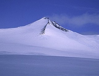
WBarbeau Peak is a mountain in Qikiqtaaluk, Nunavut, Canada. Located on Ellesmere Island within Quttinirpaaq National Park, it is the highest mountain in Nunavut and the Canadian Arctic. The mountain was named in 1969 after Marius Barbeau, a Canadian anthropologist whose research into First Nations and Inuit cultures gained him international acclaim.
 W
WBartlett Bay is an Arctic waterway in the Qikiqtaaluk Region, Nunavut, Canada. It is in Nares Strait off eastern Ellesmere Island, off the Bache Peninsula. Victoria Head marks the northern tip of its mouth.
WBaumann Fiord is a natural inlet in the south-west of Ellesmere Island, Qikiqtaaluk Region, Nunavut in the Arctic Archipelago. To the west, it opens into Norwegian Bay. Hoved Island lies in the fiord.
WBorup Fiord is located on Ellesmere Island, Qikiqtaaluk Region, Nunavut Canada. The mouth of the fiord opens into Greely Fiord. To the west is Oobloyah Bay and to the north is the Neil Peninsula and the Neil Icecap. The eastern arm, known as Esayoo Bay leads to Borup Fiord Pass.
 W
WBorup Fiord Pass is a glacier-carved valley on Ellesmere Island in Nunavut, Canada. The valley contains a natural spring which carries fluids from the subsurface to the surface, sometimes passing through the glacial ice in the process. The spring is the only known place where sulfur from a natural spring is deposited over ice. At the Borup Fiord Pass spring, hydrogen sulphide gas in the water is converted to stable deposits of either elemental sulfur, the most common material in the deposit, or gypsum. The process by which hydrogen sulfide becomes sulfur is complex, and most often occurs when microbes, like bacteria, are present.
WBuchanan Bay is an Arctic waterway in Qikiqtaaluk Region, Nunavut, Canada. It is located in Nares Strait by eastern Ellesmere Island. The bay is bordered by Cape Camperdown on Bache Peninsula to the north, Cape Rutherford on Johan Peninsula to the south, and the Alexandra Fiord at its head.
WCañon Fiord is a natural inlet in the west of Ellesmere Island, Nunavut in the Arctic Archipelago. To the north, it opens into Greely Fiord and to the east lies the Agassiz Ice Cap.
WCopes Bay is an Arctic waterway in Qikiqtaaluk Region, Nunavut, Canada. It is located in Nares Strait by eastern Ellesmere Island, and marks the northern edge of Cook Peninsula.
WDobbin Bay is an Arctic waterway in Qikiqtaaluk Region, Nunavut, Canada. It is located in Nares Strait by eastern Ellesmere Island, south of the Darling Peninsula.
 W
WEureka Aerodrome is located at Eureka, Nunavut, Canada, and is operated by Environment Canada.
 W
WEureka is a small research base on Fosheim Peninsula, Ellesmere Island, Qikiqtaaluk Region, in the Canadian territory of Nunavut. It is located on the north side of Slidre Fiord, which enters Eureka Sound farther west. It is the third-northernmost permanent research community in the world. The only two farther north are Alert, which is also on Ellesmere Island, and Nord, in Greenland. Eureka has the lowest average annual temperature and the lowest amount of precipitation of any weather station in Canada.
WFlagler Bay is an Arctic waterway in Qikiqtaaluk Region, Nunavut, Canada. It is located in Nares Strait by eastern Ellesmere Island between Bache Peninsula and Knud Peninsula.
WThe Margaret Formation is a geologic formation of the Eureka Sound Group in the Sverdrup Basin in Northwest Territories and Nunavut, Canada. The unit belonging to the Eureka Sound Group which crops out at Ellesmere Island preserves fossils dating back to the Early Eocene period, or Wasatchian in the NALMA classification.
WGreely Fiord is a natural inlet in the west of Ellesmere Island, Qikiqtaaluk Region, Nunavut in the Arctic Archipelago. To the south lies the Cañon Fiord and the Agassiz Ice Cap. To the northwest is Borup Fiord and Tanquary Fiord is northeast.
 W
WGrinnell Land is the central section of Ellesmere Island in the northernmost part of Nunavut territory in Canada. It was named for Henry Grinnell, a shipping magnate from New York, who in the 1850s helped finance two expeditions to search for Franklin's lost expedition.
 W
WGrise Fiord is an Inuit hamlet in the Qikiqtaaluk Region in the territory of Nunavut, Canada. Despite its low population, it is the largest community and only public community on Ellesmere Island. The settlement at Grise Fiord, created by the Canadian Government in 1953 through a forced relocation of Inuit families from Inukjuak, Quebec, is the northernmost public community in Canada. It is also one of the coldest inhabited places in the world, with an average yearly temperature of −16.5 °C (2.3 °F).
WGrise Fiord is a waterway on Ellesmere Island, Qikiqtaaluk Region, Nunavut, Canada. Grise Fiord means "pig inlet" in Norwegian. Otto Sverdrup from Norway named it so during an expedition around 1900 because he thought the walrus in the area sounded like pigs. It feeds into Jones Sound and out into Baffin Bay. The Inuit community of Grise Fiord, the northernmost civilian settlement in Canada, is located at the south end of the fiord.
 W
WGull Glacier is a glacier in the Osborn Range of north-central Ellesmere Island, Nunavut, Canada. It lies in the Tanquary Fiord in Quttinirpaaq National Park.
 W
WHall Basin is an Arctic waterway between Hall Land in Greenland to the west and Canada's northernmost island to the east, Ellesmere Island.
 W
WThe High Arctic camel, from the mid-Pliocene epoch, is a fossil camel related to the fossil genus Paracamelus from which modern camels arose. It is also related to the extinct Ice Age Yukon giant camel. Collagen-containing fossils were found in 2006 near Strathcona Fiord on Ellesmere Island in Nunavut, Canada. The High Arctic camel lived at least 3.4 million years ago during a warmer period in a boreal-type forest environment.
WIrene Bay is an Arctic waterway in Qikiqtaaluk Region. Nunavut, Canada. It is located in Eureka Sound by western Ellesmere Island.
 W
WThe Judge Daly Promontory is located on the eastern coast of Ellesmere Island, a part of the Qikiqtaaluk Region of the Canadian territory of Nunavut. It stretches from the southwest northeastward into Nares Strait. Lady Franklin Bay is to the north, Archer Fiord to the west, and Cape Baird is its northernmost point.
 W
WThe Lindstrom Peninsula is located on the southern coast of Ellesmere Island, a part of the Qikiqtaaluk Region of the Canadian territory of Nunavut. Across Baffin Bay to the south lies Devon Island. Harbour Fiord and Landslip Island are to the west, while the Grise Fiord is to the east. The highest peak on the peninsula is Mount Aqiatushuk 76°25′40″N 083°15′00″W.
WOkse Bay is an Arctic waterway in Qikiqtaaluk Region, Nunavut, Canada. It is located in Norwegian Bay by southwestern Ellesmere Island, east of Buckingham Island.
WPeary Bay is an Arctic waterway in Qikiqtaaluk Region, Nunavut, Canada. It is located in Nares Strait by eastern Ellesmere Island between the Cook Peninsula and the Bache Peninsula.
WPrincess Marie Bay is an Arctic waterway in Qikiqtaaluk Region, Nunavut, Canada. It is located in Nares Strait by eastern Ellesmere Island, and marks the southwestern edge of Cook Peninsula. It is also south of the Sven Hedin Glacier.
 W
WQuttinirpaaq National Park is a Canadian national park. Located on the northeastern corner of Ellesmere Island in the Qikiqtaaluk Region of Nunavut, the most northerly extent of Canada, it is the second most northerly park on Earth after Northeast Greenland National Park. In Inuktitut, Quttinirpaaq means "top of the world". It was established as Ellesmere Island National Park Reserve in 1988, and the name was changed to Quttinirpaaq in 1999, when Nunavut was created, and became a national park in 2000. The reserve covers 37,775 km2 (14,585 sq mi), making it the second largest park in Canada, after Wood Buffalo National Park.
WSawyer Bay is an Arctic waterway in Qikiqtaaluk Region, Nunavut, Canada. It is located in Nares Strait by eastern Ellesmere Island. Benedict Glacier fills the head of the bay.
WScoresby Bay is an Arctic waterway in Qikiqtaaluk Region, Nunavut, Canada. It is located in Nares Strait by eastern Ellesmere Island's Darling Peninsula, west of Nunatami, Greenland.
 W
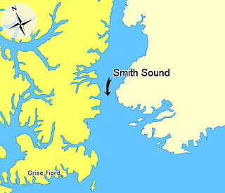
WSmith Sound is an uninhabited Arctic sea passage between Greenland and Canada's northernmost island, Ellesmere Island. It links Baffin Bay with Kane Basin and forms part of the Nares Strait.
WStrathcona Fiord is a fiord on the west central coast of Ellesmere Island, the most northern island within the Arctic Archipelago, Nunavut, Canada.
 W
WSylvia Grinnell Territorial Park is a Canadian territorial park located 1 km away from Iqaluit, the capital of Nunavut territory in Canada. The Sylvia Grinnell river flows through the park. The park also has archaeological sites of the Dorset culture and the Thule people.
 W
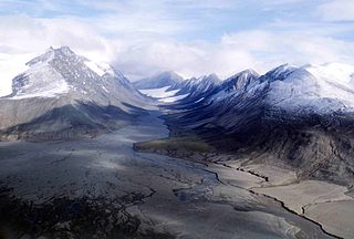
WTanquary Fiord is a fjord on the north coast of the Arctic Archipelago's Ellesmere Island, Nunavut, Canada. It is located in the Quttinirpaaq National Park and extends 30 mi (48 km) in a north-westerly direction from Greely Fiord.
WVendom Fiord is a natural inlet in the south-west of Ellesmere Island, Nunavut in the Arctic Archipelago. To the south, it opens into Baumann Fiord.
 W
WThe Ward Hunt Ice Shelf is the largest ice shelf in the Arctic, located on the north coast of Ellesmere Island, Nunavut, Canada. During the 20th century the Ellesmere Ice Shelf broke up into six separate shelves, the largest being Ward Hunt. Ward Hunt Ice Shelf is currently about 155 square miles (400 km2) in size, and has been in place for approximately 4,000 years as part of a continuous ice shelf that encompassed the northern coast of Ellesmere Island until the beginning of the twentieth century. In 2005 one of the other shelves, the 25-square-mile (65 km2) Ayles Ice Shelf, calved completely.