 W
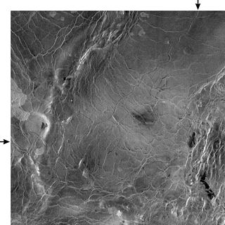
WBaltis Vallis is a sinuous channel on Venus ranging from one to three kilometers wide and ~6,800 kilometers long, slightly longer than the Nile and the longest known channel of any kind in the solar system. It is thought the channel once held a river of lava. It is a single channel over most of its length, but anastomoses in several sections, for lengths of up to 400 km. There appear to be other, smaller channels in the same area, down to the limit of resolution, some of which seem to be tributaries of Baltis Vallis.
 W
WThe Burnt Mountain is a hill with a solidified lava flow at the foot of a 12-kilometre-long volcanic ridge in Damaraland in northern Namibia. The 80-million-year-old stream of lava was formed by thermal and compression metamorphism and its red, brown, cream and purple colours creates a striking contrast at dusk with the surrounding 200-million-year-old beige rocks of Karoo slate. During the contact metamorphism that was caused by the intrusion, volatile organic components were driven off from the shale, leaving a charred black, clinker like burnt mass from which the mountain got its name.
 W
WA cinder cone is a steep conical hill of loose pyroclastic fragments, such as either volcanic clinkers, volcanic ash, or cinder that has been built around a volcanic vent. The pyroclastic fragments are formed by explosive eruptions or lava fountains from a single, typically cylindrical, vent. As the gas-charged lava is blown violently into the air, it breaks into small fragments that solidify and fall as either cinders, clinkers, or scoria around the vent to form a cone that often is symmetrical; with slopes between 30–40°; and a nearly circular ground plan. Most cinder cones have a bowl-shaped crater at the summit.
 W
WA complex volcano, also called a compound volcano, is mixed landform consisting of related volcanic centers and their associated lava flows and pyroclastic rock. They may form due to changes in eruptive habit or in the location of the principal vent area on a particular volcano. Stratovolcanoes can also form a large caldera that gets filled in by a lava dome, or else multiple small cinder cones, lava domes and craters may develop on the caldera's rim.
 W
WA cupola is a recess, indentation, or cavity in the ceiling of a lava tube, a kind of cave formation. Cupolas may originate from partial collapse of the ceiling, inflation of the roof by gas or lava pressure, or from a roofed-over site of a former tube overflow. They can be situated anywhere in a lava tube but are most common in lower-level passages.
 W
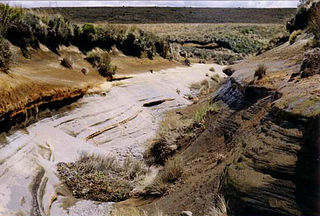
WEl Elegante is a maar located in the Gran Desierto de Altar in the Sonoran Desert, Mexico.
 W
WA geyser is a spring characterized by an intermittent discharge of water ejected turbulently and accompanied by steam. As a fairly rare phenomenon, the formation of geysers is due to particular hydrogeological conditions that exist only in a few places on Earth. Generally all geyser field sites are located near active volcanic areas, and the geyser effect is due to the proximity of magma. Generally, surface water works its way down to an average depth of around 2,000 metres (6,600 ft) where it contacts hot rocks. The resultant boiling of the pressurized water results in the geyser effect of hot water and steam spraying out of the geyser's surface vent.
 W
WHornitos are conical structures built up by lava ejected through an opening in the crust of a lava flow. Hornitos are similar to spatter cones but are rootless, meaning they were once a source of lava but that source was not directly associated with a true vent or magma source. They are usually created by the slow upwelling of lava through the roof of a lava tube. High pressure causes lava to ooze and spatter out. The lava builds up on the surface and solidifies creating the initial structure. Hornitos can grow and exceed 10 meters in height.
 W
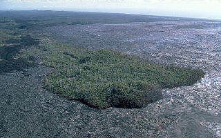
WA kīpuka is an area of land surrounded by one or more younger lava flows. A kīpuka forms when lava flows on either side of a hill, ridge, or older lava dome as it moves downslope or spreads from its source. Older and more weathered than their surroundings, kīpukas often appear to be like islands within a sea of lava flows. They are often covered with soil and late ecological successional vegetation that provide visual contrast as well as habitat for animals in an otherwise inhospitable environment. In volcanic landscapes, kīpukas play an important role as biological reservoirs or refugia for plants and animals, from which the covered land can be recolonized.
 W
WKronotsky (Кроноцкий) Nature Reserve is a nature area reserved for the study of natural sciences in the remote Russian Far East, on the coast of the Kamchatka Peninsula. It was created in 1934 and its current boundary contains an area of 10,990 km2 (4,240 sq mi). The largest lake in the reserve is Lake Kronotskoye, which covers an area of 246 square kilometres (95 sq mi). It also has Russia's only geyser basin, plus several mountain ranges with numerous volcanoes, both active and extinct. Due to its often harsh climate and its mix of volcanoes and geysers, it is frequently described as the Land of Fire and Ice.
 W
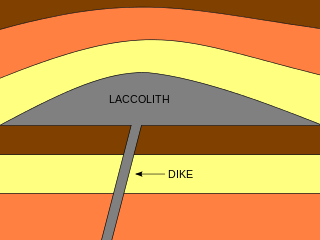
WA laccolith is a sheet-like intrusion that has been injected within or between layers of sedimentary rock. The pressure of the magma is high enough that the overlying strata are forced upward and folded, giving the laccolith a dome or mushroom-like form with a generally planar base. Over time, erosion can form small hills and even mountains around a central peak since the magma rock is likely more resistant to weathering than the host rock. The growth of laccoliths can take as little as a few months when associated with a single magma injection event, or up to hundreds or thousands of years by multiple magmatic pulses stacking sills on top of each other and deforming the host rock incrementally.
 W
WLava deltas, similar to river deltas form wherever sufficient sub-aerial flows of lava enter standing bodies of water. The lava cools and breaks up as it encounters the water, with the resulting fragments filling in the adjacent seabed topography such that the flow can move further offshore sub-aerially. Lava deltas are generally associated with large-scale, effusive type basaltic volcanism.
 W
WA lava channel is a stream of fluid lava contained within zones of static lava or lava levees. The initial channel may not contain levees per se, until the parental flow solidifies over what develops into the channel and creates natural levees. This initial levee allows for the building of a more complex levee and channel. As the lava flows through the channel, the elevation of the surface of the lava flow pulsates and lava can possibly flood the associated channel walls spilling out of the channel and over the existing levees, creating what is known as overflow levees. Overflow levees increase the height and width of the original levee. The lava that flows in lava channels is commonly basaltic in composition.
 W
WIn volcanology, a lava dome is a circular mound-shaped protrusion resulting from the slow extrusion of viscous lava from a volcano. Dome-building eruptions are common, particularly in convergent plate boundary settings. Around 6% of eruptions on earth are lava dome forming. The geochemistry of lava domes can vary from basalt to rhyolite although the majority are of intermediate composition The characteristic dome shape is attributed to high viscosity that prevents the lava from flowing very far. This high viscosity can be obtained in two ways: by high levels of silica in the magma, or by degassing of fluid magma. Since viscous basaltic and andesitic domes weather fast and easily break apart by further input of fluid lava, most of the preserved domes have high silica content and consist of rhyolite or dacite.
 W
WLava lakes are large volumes of molten lava, usually basaltic, contained in a volcanic vent, crater, or broad depression. The term is used to describe both lava lakes that are wholly or partly molten and those that are solidified.
 W
WA lava field, also called a lava plain or lava bed, is a large expanse of nearly flat-lying lava flows. Such features are generally composed of highly fluid basalt lava, and can extend for tens or even hundreds of miles across the underlying terrain. The extent of large lava fields is most readily grasped from the air or in satellite photos, where their typically dark, nearly black color contrasts sharply with the rest of the landscape.
 W
WA lava spine is a vertical growth of solid lava that is forced from a volcanic vent. A lava spine can either be formed by viscous lava slowly being pushed out of the vent, or by magma that has solidified within the vent before being pushed out.
 W
WA lava tube, or pyroduct, is a natural conduit formed by flowing lava from a volcanic vent that moves beneath the hardened surface of a lava flow. If lava in the tube empties, it will leave a cave.
 W
WLittoral cones are a form of volcanic cone. They form from the interaction between lava flows and water. Steam explosions fragment the lava and the fragments can pile up and form a cone. Such cones usually form on aa lava flows, and typically require large lava flows to form. They have been found on Hawaii and elsewhere.
 W
WA maar is a broad, low-relief volcanic crater caused by a phreatomagmatic eruption. A maar characteristically fills with water to form a relatively shallow crater lake which may also be called a maar. The name comes from a Moselle Franconian dialect word used for the circular lakes of the Daun area of Germany.
 W
WMalpaís is a term used in the Southwestern United States, Spain, Mexico, and other Spanish-speaking regions for a rough and barren landscape that consists of relict and largely uneroded lava fields exhibiting recognizable lava flows, volcanic cones, and other volcanic landforms. This type of volcanic landscape is extremely rough and difficult to traverse. It is characteristic of an arid environment because in more humid climates, lava fields are quickly destroyed by weathering and erosion.
 W
WA mid-ocean ridge (MOR) is a seafloor mountain system formed by plate tectonics. It typically has a depth of ~ 2,600 meters (8,500 ft) and rises about two kilometers above the deepest portion of an ocean basin. This feature is where seafloor spreading takes place along a divergent plate boundary. The rate of seafloor spreading determines the morphology of the crest of the mid-ocean ridge and its width in an ocean basin. The production of new seafloor and oceanic lithosphere results from mantle upwelling in response to plate separation. The melt rises as magma at the linear weakness between the separating plates, and emerges as lava, creating new oceanic crust and lithosphere upon cooling. The first discovered mid-ocean ridge was the Mid-Atlantic Ridge, which is a spreading center that bisects the North and South Atlantic basins; hence the origin of the name 'mid-ocean ridge'. Most oceanic spreading centers are not in the middle of their hosting ocean basis but regardless, are traditionally called mid-ocean ridges. Mid-ocean ridges around the globe are linked by plate tectonic boundaries and the trace of the ridges across the ocean floor appears similar to the seam of a baseball. The mid-ocean ridge system thus is the longest mountain range on Earth, reaching about 65,000 km (40,000 mi).
 W
WMofetta, is a name applied to a volcanic discharge consisting chiefly of carbon dioxide, often associated with other vapours, representing the final phase of volcanic activity. The Oxford Dictionary of English lists mofetta as an archaic term for the modern word fumarole.
 W
WMount Batok is a cinder cone located in East Java, Indonesia. This volcano has an elevation of 2,440 meters above sea level, and is located between four regencies: Probolinggo Regency, Pasuruan Regency, Lumajang Regency, and Malang Regency. The location of Mount Batok is west from Mount Bromo. This mountain is one of the inactive volcanoes located within the Tengger caldera. Mount Batok is part of Bromo Tengger Semeru National Park.
 W
WA mudpot, or mud pool, is a sort of acidic hot spring, or fumarole, with limited water. It usually takes the form of a pool of bubbling mud. The acid and microorganisms decompose surrounding rock into clay and mud.
 W
WA pit crater is a depression formed by a sinking or collapse of the surface lying above a void or empty chamber, rather than by the eruption of a volcano or lava vent. Pit craters are found on Mercury, Venus, Earth, Mars, and the Moon. Pit craters are often found in a series of aligned or offset chains and in these cases, the features is called a pit crater chain. Pit crater chains are distinguished from catenae or crater chains by their origin. When adjoining walls between pits in a pit crater chain collapse, they become troughs. In these cases, the craters may merge into a linear alignment and are commonly found along extensional structures such as fractures, fissures and graben. Pit craters usually lack an elevated rim as well as the ejecta deposits and lava flows that are associated with impact craters. Pit craters are characterized by vertical walls that are often full of fissures and vents. They usually have nearly circular openings.
 W
WPuy is a geological term used locally in the Auvergne, France for a volcanic hill. The word derives from the Provençal puech, meaning an isolated hill, coming from Latin podium, which has given also puig in Catalan, poggio in Italian, poio in Galician and Portuguese.
 W
WIn volcanology, a pyroclastic shield or ignimbrite shield is an uncommon type of shield volcano. Unlike most shield volcanoes, pyroclastic shields are formed mostly of pyroclastic and highly explosive eruptions rather than relatively fluid basaltic lava issuing from vents or fissures on the surface of the volcano. They typically display low-angle flank slopes and often have a central caldera caused by large eruptions. Lava is commonly extruded after explosive activity has ended. The paucity of associated Plinian fall deposits indicates that pyroclastic shields are characterized by low Plinian columns.
 W
WRille is typically used to describe any of the long, narrow depressions in the surface of the Moon that resemble channels. The Latin term is rima, plural rimae. Typically a rille can be up to several kilometers wide and hundreds of kilometers in length. However, the term has also been used loosely to describe similar structures on a number of planets in the Solar System, including Mars, Venus, and on a number of moons. All bear a structural resemblance to each other.
 W
WA rootless cone, also formerly called a pseudocrater, is a volcanic landform which resembles a true volcanic crater, but differs in that it is not an actual vent from which lava has erupted. They are characterised by the absence of any magma conduit which connects below the surface of a planet.
 W
WA scalloped margin dome is a type of volcanic dome, found on Venus, that has experienced collapse and mass wasting such as landslides on its perimeter. The margins of these domes have arcuate headscarps or 'scallops' separated by ridges that are a consequence of adjoining scallops. Sometimes debris or slumping can be found at the bottom of these scarps or scattered many tens of kilometers away. Many examples show no debris at all. The center of these domes is often, but not always, a depression. There is another theory that the radial ridges of scalloped margin domes are volcanic dikes.
 W
WA shield volcano is a type of volcano usually composed almost entirely of fluid lava flows. It is named for its low profile, resembling a warrior's shield lying on the ground. This is caused by the highly fluid lava erupted, which travels farther than lava erupted from a stratovolcano, and results in the steady accumulation of broad sheets of lava, building up the shield volcano's distinctive form.
 W
WA stratovolcano, also known as a composite volcano, is a conical volcano built up by many layers (strata) of hardened lava, tephra, pumice and ash. Unlike shield volcanoes, stratovolcanoes are characterized by a steep profile with a summit crater and periodic intervals of explosive eruptions and effusive eruptions, although some have collapsed summit craters called calderas. The lava flowing from stratovolcanoes typically cools and hardens before spreading far, due to high viscosity. The magma forming this lava is often felsic, having high-to-intermediate levels of silica, with lesser amounts of less-viscous mafic magma. Extensive felsic lava flows are uncommon, but have travelled as far as 15 km (9.3 mi).
 W
WA subglacial mound (SUGM) is a type of subglacial volcano. This type of volcano forms when lava erupts beneath a thick glacier or ice sheet. The magma forming these volcanoes was not hot enough to melt a vertical pipe right through the overlying glacial ice, instead forming hyaloclastite and pillow lava deep beneath the glacial ice field. Once the glaciers had retreated, the subglacial volcano would be revealed, with a unique shape as a result of their confinement within glacial ice. They are somewhat rare worldwide, being confined to regions which were formerly covered by continental ice sheets and also had active volcanism during the same period. They are found throughout Iceland, Antarctica and the Canadian province of British Columbia.
 W
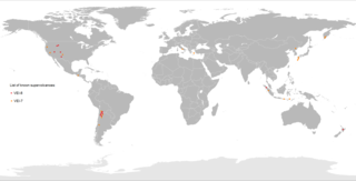
WA supervolcano is a large volcano that has had an eruption with a Volcanic Explosivity Index (VEI) of 8, the largest recorded value on the index. This means the volume of deposits for that eruption is greater than 1,000 cubic kilometers.
 W
WVolcanic cones are among the simplest volcanic landforms. They are built by ejecta from a volcanic vent, piling up around the vent in the shape of a cone with a central crater. Volcanic cones are of different types, depending upon the nature and size of the fragments ejected during the eruption. Types of volcanic cones include stratocones, spatter cones, tuff cones, and cinder cones.
 W
WA volcanic crater is an approximately circular depression in the ground caused by volcanic activity. It is typically a bowl-shaped feature within which occurs a vent or vents. During volcanic eruptions, molten magma and volcanic gases rise from an underground magma chamber, through a tube-shaped conduit, until they reach the crater's vent, from where the gases escape into the atmosphere and the magma is erupted as lava. A volcanic crater can be of large dimensions, and sometimes of great depth. During certain types of explosive eruptions, a volcano's magma chamber may empty enough for an area above it to subside, forming a type of larger depression known as a caldera.
 W
WA volcanic desert is an area devoid of vegetation because of volcanic activity. Usually the term is applied to larger areas such as the Highlands of Iceland, the Rangipo Desert in New Zealand or Cordón Caulle in Chile. Occasionally the term is used for relatively small regions such as the Kaʻū Desert on the island of Hawai'i. Volcanic deserts may have enough precipitation to sustain vegetation, but due to repeated covering of tephra and acid rain after eruptions and high percolation and infiltration rates of water, vegetation is scarce. In addition to this volcanic desert shows often poor or little soil formation due to slow chemical weathering caused by cold climate or coarse tephra. The Plaine des Sables, on Réunion, is close to the Commerson Crater, a place which holds several world records of rainfall.
 W
WA volcanic plateau is a plateau produced by volcanic activity. There are two main types: lava plateaus and pyroclastic plateaus.
 W
WA volcanic plug, also called a volcanic neck or lava neck, is a volcanic object created when magma hardens within a vent on an active volcano. When present, a plug can cause an extreme build-up of pressure if rising volatile-charged magma is trapped beneath it, and this can sometimes lead to an explosive eruption. Glacial erosion can lead to exposure of the plug on one side, while a long slope of material remains on the opposite side. Such landforms are called crag and tail. If a plug is preserved, erosion may remove the surrounding rock while the erosion-resistant plug remains, producing a distinctive upstanding landform.
 W
WA volcano is a rupture in the crust of a planetary-mass object, such as Earth, that allows hot lava, volcanic ash, and gases to escape from a magma chamber below the surface.
 W
WA volcanogenic lake is a lake formed as a result of volcanic activity. They are generally a body of water inside an inactive volcanic crater but can also be large volumes of molten lava within an active volcanic crater and waterbodies constrained by lava flows, pyroclastic flows or lahars in valley systems. The term volcanic lake is also used to describe volcanogenic lakes, although it is more commonly assigned to those inside volcanic craters.