 W
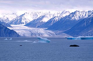
WThe Agassiz Ice Cap formerly Agassiz Glacier is an ice cap on the central eastern side of Ellesmere Island, Nunavut, Canada. The Agassiz ice cap is about 21,000 km2 (8,100 sq mi) in area. It is located between the North Ellesmere ice field to the north and the Prince of Wales Icefield to the south.
 W
WThe Angel Glacier is an extensive glacier which flows down the north face of Mount Edith Cavell in Jasper National Park, Canada. It is named as such because it has the appearance of an angel with out-swept wings. It was significantly larger when it was named in the 19th-century and is melting rapidly. It is not expected to maintain its shape, and will most likely disappear.
 W
WMount Jacobsen, 3031 m, is a mountain in the northernmost Pacific Ranges of the Coast Mountains in the Central Coast region of British Columbia, Canada, located to the south of the Bella Coola Valley and immediately south of Ape Lake, to the west of the valley of the Talchako River.
 W
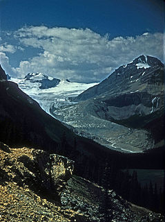
WThe Athabasca Glacier is one of the six principal 'toes' of the Columbia Icefield, located in the Canadian Rockies. The glacier currently loses depth at a rate of about 5 metres (16 ft) per year and has receded more than 1.5 km (0.93 mi) and lost over half of its volume in the past 125 years. Easily accessible, it is the most visited glacier in North America. The leading edge of the glacier is within easy walking distance; however, travel onto the glacier is not recommended unless properly equipped. Hidden crevasses have led to the deaths of unprepared tourists.
 W
WThe Barnes Ice Cap is an ice cap located in central Baffin Island, Nunavut, Canada.
 W
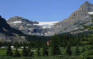
WBow Glacier is located in Banff National Park, Alberta, Canada, approximately 37 km (23 mi) northwest of Lake Louise. It can be viewed from the Icefields Parkway. Bow Glacier is an outflow glacier from the Wapta Icefield, which rests along the Continental Divide, and runoff from the glacier supplies water to Bow Lake and the Bow River. The glacier is credited for creating the Bow Valley before retreating at the end of the last glacial maximum.
WChaos Glacier is part of the Waddington Range in the southern British Columbia Coast Mountains in Canada, located at 51°25′25″N 125°15′5″W. It flows to the north from Mount Tiedemann for approximately four kilometers before joining the larger Scimitar Glacier. The name was officially adopted in 1978 from field sketches of the area by mountaineer Don Munday. The area's steep terrain makes this an excellent example of a continuous ice fall.
 W
WThe Comox Glacier is a glacier on Vancouver Island, British Columbia, Canada, located 30 km (19 mi) southwest of Courtenay and 1 km (0.62 mi) west of Argus Mountain.
 W
WCoronation Glacier is a glacier on southeastern Baffin Island, Nunavut, Canada. The glacier is on the northeast coast of Cumberland Peninsula and is an outlet glacier of the Penny Ice Cap. The Coronation Glacier lost its connection to the Elena Glacier between 1943 and 1949.
 W
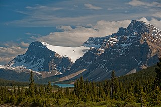
WCrowfoot Glacier is located in Banff National Park, Alberta, Canada, 32 km (20 mi) northwest of Lake Louise, and can be viewed from the Icefields Parkway. The glacier is situated on the northeastern flank of Crowfoot Mountain.
 W
WThe Devon Ice Cap is an ice cap on eastern Devon Island, Nunavut, Canada, covering an area of over 12,000 km2 (4,600 sq mi). The highest point on Devon Island is found at the summit of the ice cap, with an elevation of 1,921 m (6,302 ft). The ice cap has a maximum thickness of 880 m (2,887 ft), and has been steadily shrinking since 1985.
 W
WGull Glacier is a glacier in the Osborn Range of north-central Ellesmere Island, Nunavut, Canada. It lies in the Tanquary Fiord in Quttinirpaaq National Park.
 W
WThe Ha-Iltzuk Icefield is an icefield in the central Pacific Ranges of the Coast Mountains in British Columbia, Canada. It is the largest icefield in the Coast Mountains south of the Alaska Panhandle, with an area of 3,610 km2 (1,390 sq mi). It is located on the west side of the Klinaklini River and the Waddington Range. The highest summit in the icefield is Mount Silverthrone, which is a mountain on the northeast edge of a circular, 20 km (12 mi) wide, deeply dissected caldera complex called the Silverthrone Caldera.
 W
WThe Homathko Icefield is an icefield in British Columbia, Canada. Officially named the Homathko Snowfield from 1950 until the current name was adopted in 1976, it is one of the largest icefields in the southern half of the Coast Mountains, with an area of over 2,000 km2 (770 sq mi). It is located between Chilko Lake and the Homathko River, and lies across the Great Canyon of that river to the east of the Waddington Range. Although adjacent to Mount Queen Bess, the Homathko Icefield is largely an expanse of ice, about 30 km (19 mi) across, ringed by relatively minor peaks and distinguished, relative to the other Coast Mountains icefields, by lack of any major ones. The Lillooet Icecap and the Compton Névé, both similar in size to the Homathko Icefield but much more peak-studded, lie to the Homathko Icefield's southeast across the Southgate River which bends around the icefield-massif's southern flank to reach the head of Bute Inlet adjacent to the mouth of the Homathko River. The icefield is essentially one large ice-girt montane plateau between these two rivers.
 W
WHoodoo Glacier is a glacier in northwestern British Columbia, Canada, located on the western flank of Hoodoo Mountain. It lies at the headwaters of the Hoodoo River.
 W
WThe Horstman Glacier is a glacier located on Blackcomb Peak in Garibaldi Provincial Park. During the ski season at Whistler Blackcomb Ski Resort, it is used for skiing and riding on. During the summer ski season on Blackcomb Peak, it is one of two glaciers in the North America used for summer skiing and riding.
 W
WKaparoqtalik Glacier is a glacier located in the southern coast of the Byam Martin Mountains on Bylot Island, Nunavut, Canada. It lies in Sirmilik National Park.
 W
WThe Kingcome Glacier is a glacier located at the head of the Kingcome River in southwestern British Columbia, Canada.
 W
WThe Klinaklini Glacier is a glacier west of the Klinaklini River and head of Knight Inlet the Coast Land District of British Columbia, Canada. It flows generally southward from Mt. Silverthrone. The glacier is one of the largest glaciers in western North America. The Hakai Institute has installed a weather station and camera above Klinaklini Glacier that will provide data in near real time to scientists and operational users.
 W
WKokanee Glacier Provincial Park is one of the oldest provincial parks in British Columbia, established in 1922. The park has an area of 320.35 km2 (123.69 sq mi) and is located in the Selkirk Mountains in the West Kootenays region of BC. The park has three glaciers that feed over 30 alpine lakes which are the headwaters of many creeks.
 W
WLogan Glacier is a glacier in the U.S. state of Alaska and province of Yukon, Canada. It heads down the northern slopes of Mount Logan in the Yukon, flowing northwest across the Canada-United States boundary to form the headwaters of the Chitina River. It was named for its nearness to Mount Logan.
 W
WThe Mamquam Icefield is an icefield in southwestern British Columbia, Canada, located at the headwaters of Skookum Creek. It lies at the southern end of Garibaldi Provincial Park and is one of the southernmost icefields in the Pacific Ranges of the Coast Mountains. The highest summit of the icefield is Mamquam Mountain, located at its southern end with an elevation of 2,588 m (8,491 ft).
 W
WThe Misty Icefield is a high glaciated plateau in the Garibaldi Ranges of the Pacific Ranges of the Coast Mountains. It is located in the eastern part of Garibaldi Provincial Park and the northern portion of Golden Ears Provincial Park. The Misty Icefield was mapped and named in 1955, and rarely visited since, mainly due to its remote location. The area includes the Stave Glacier, and the Snowcap Glacier
 W
WThe Monarch Icefield is the northernmost of a series of large continental icecaps studding the heights of the Pacific Ranges of the Coast Mountains in southern British Columbia. Located southeast of the town of Bella Coola and west of the headwaters of the Atnarko River, a tributary of the Bella Coola River, it lies to the north of the Ha-Iltzuk Icefield, which is the largest icefield of the group and home to the Silverthrone volcano. The Monarch Icefield is very remote and is rarely visited by mountaineering parties.
WMount Jacobsen, 3031 m, is a mountain in the northernmost Pacific Ranges of the Coast Mountains in the Central Coast region of British Columbia, Canada, located to the south of the Bella Coola Valley and immediately south of Ape Lake, to the west of the valley of the Talchako River.
WParallel Glacier is part of the Waddington Range in the southern British Columbia Coast Mountains. It is a small alpine glacier on the north side of Umbra Ridge. It extends to the northeast from Mount Geddes toward Pocket Valley.
 W
WThe Pashleth Glacier is a glacier south of the Machmell River and west of the Klinaklini Glacier in southwestern British Columbia, Canada.
 W
WThe Penny Ice Cap, formerly Penny Icecap, is a 6,000 km2 (2,300 sq mi) ice cap in Auyuittuq National Park of Baffin Island, Nunavut, Canada. It forms a 2,000 m (6,562 ft) high barrier on the Cumberland Peninsula, an area of deep fjords and glaciated valleys. It is a remnant of the last ice age. During the mid-1990s, Canadian researchers studied the glacier's patterns of freezing and thawing over centuries by drilling ice core samples.
 W
WThe Peyto Glacier is situated in the Canadian Rockies in Banff National Park, Alberta, Canada, approximately 90 km (56 mi) northwest of the town of Banff, and can be accessed from the Icefields Parkway. Peyto Glacier is an outflow glacier from the Wapta Icefield, which rests along the Continental divide. The glacier snout is subject to high melt rates from season to season and there is marked surface lowering on several parts of the glacier. Glacial silt, which is carried from the glacier by streams, ensures a turquoise appearance to Peyto Lake, a popular touring destination. As is true for the vast majority of glaciers worldwide, Peyto Glacier has been retreating rapidly, especially since the last half of the 20th century, and has reportedly lost 70% of its mass since it was first researched (Demuth and Keller, 2006). Between 1896 and 1966, the total volume loss of the Peyto Glacier was 1088.5 x 106 m3 (Wallace, 1995). In 1987, an automatic weather station was constructed near the glacier that monitors temperature changes, radiation and precipitation.
WRadiant Glacier is part of the Waddington Range in the southern British Columbia Coast Mountains. It flows to the northeast from Mount Tiedemann for approximately 5 km (3.1 mi) before joining the larger Scimitar Glacier.
 W
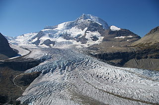
WThe Robson Glacier is the primary source of the short Robson River, one of the uppermost tributaries of the Fraser River. Located on the British Columbia-Alberta Boundary and the Continental Divide to the east of Berg Lake in Mount Robson Provincial Park, it sits on the northeast flank of Mount Robson in Mount Robson Provincial Park, British Columbia in the Canadian Rockies. Its meltwater feeds unofficially named Robson Lake, whose outlet marks the start of the Robson River.
 W
WThe Salmon Glacier is a glacier located ~25 km (16 mi) north of Stewart, British Columbia, and Hyder, Alaska, just on the Canadian side of the border. The glacier, one of hundreds in the Boundary Ranges, is notable for its major potential as a natural hazard. Summit Lake is located at the northern end of the glacier and every year around mid-July the lake breaks an ice-dam and then flows under the Salmon Glacier into the Salmon River. This causes the river to rise approximately 4–5 ft (1.2–1.5 m) for several days.
 W
WThe Saskatchewan Glacier is located in Banff National Park, Alberta, Canada, approximately 120 km (75 mi) northwest of the town of Banff, and can be accessed from the Icefields Parkway. Saskatchewan Glacier is the largest outflow glacier from the Columbia Icefield, which rests along the Continental Divide. The glacier is a primary water source for the North Saskatchewan River. The glacier is approximately 13 kilometres (8.1 mi) long and covers an area of 30 km² (11.5 mi²) and was measured in 1960 to be over 400 metres (1,300 ft) thick at a distance of 8 kilometres (5.0 mi) from the terminal snout. Between the years 1893 and 1953, Saskatchewan Glacier had retreated a distance of 1,364 metres (4,475 ft), with the rate of retreat between the years 1948 and 1953 averaging 55 metres (180 ft) per year.
WMount Saugstad is a mountain in the northernmost Pacific Ranges of the Coast Mountains in the Central Coast region of British Columbia, Canada. It is located just south of the community of Hagensborg in the Bella Coola Valley and is immediately southeast of Snootli Peak and also southeast of Big Snow Mountain. The Smitley River has its origins on the west side of the summit at the Saugstad Glacier, which is at 52°15′48″N 126°31′36″W
 W
WSermilik Glacier is a glacier located in the southern Byam Martin Mountains of Bylot Island, Nunavut, Canada. It lies in Sirmilik National Park.
WThe Silverthrone Glacier is a glacier at the northwest head of Knight Inlet in southwestern British Columbia, Canada.
 W
WSirngmikuluk formerly Narsarsuk Glacier is a glacier in the southeastern Byam Martin Mountains of Bylot Island, Nunavut, Canada.
 W
WThe Stanley Glacier locality in British Columbia is an exposure of the "thin" Stephen formation exhibiting soft-tissue preservation. Fossils were discovered by a hiker who reported the find to Parks Canada; this brought the site to the attention of scientists who were able to study the site and describe the new biota. The discovery of Burgess Shale-type preservation in the thin Stephen was unexpected, given the absence of the Cathedral escarpment in the area. Several new species, including Stanleycaris, have already been found in exploratory excavations at the site.
 W
WThe Stikine Icecap is a large icefield straddled on the Alaska–British Columbia boundary in the Alaska Panhandle region. It lies in the Boundary Ranges of the Coast Mountains. Within the United States, most of it is under the administration of the Tongass National Forest and is part of the Stikine-LeConte Wilderness within the national forest.
 W
WThe Trudel Glacier is a glacier at the head of Trudel Creek in southwestern British Columbia, Canada.
WTwin Glacier is a glacier in northwestern British Columbia, Canada, located on the northern and eastern flanks of Hoodoo Mountain. It lies at the headwaters of the Twin River.
 W
WThe Wapta Icefield is located on the Continental Divide in the Waputik Mountains of the Canadian Rockies, in the provinces of British Columbia and Alberta. The icefield is shared by Banff and Yoho National Parks and numerous outlet glaciers extend from the icefield, including the Vulture, Bow and Peyto Glaciers. Runoff from the icefields and outlet glaciers supply water to both the Kicking Horse and Bow Rivers, as well as numerous streams and lakes.
 W
WThe Waputik Icefield is located on the Continental divide in the Canadian Rocky Mountains, in the provinces of British Columbia and Alberta. It is developed on the heights of the Waputik Range in the Central Main Ranges.