 W
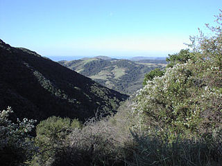
WThe Santa Ynez Mountains are a portion of the Transverse Ranges, part of the Pacific Coast Ranges of the west coast of North America. It is the westernmost range in the Transverse Ranges.
 W
WAmsinckia douglasiana is an uncommon species of fiddleneck known by the common name Douglas' fiddleneck. It is endemic to the coastal Santa Monica Mountains and Santa Ynez Mountains of southern California.
 W
WCeanothus megacarpus is a species of flowering shrub known by the common name bigpod ceanothus. This Ceanothus is endemic to California, where its distribution extends along the Central Coast and includes the Channel Islands.
 W
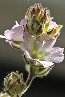
WSidalcea hickmanii is a species of flowering plant in the mallow family known generally by the common name chaparral checkerbloom.
 W
WArctostaphylos purissima is a species of manzanita known by the common name La Purisima manzanita.
 W
WArctostaphylos refugioensis is a species of manzanita, known by the common name Refugio manzanita. It is endemic to Santa Barbara County, California, where it can be found along the immediate coastline, including the vicinity of Refugio State Beach, and into the Santa Ynez Mountains of the northwestern Transverse Ranges.
 W
WState Route 154 is a state highway in the U.S. state of California that runs from Los Olivos to Santa Barbara, crossing the San Marcos Pass in the Santa Ynez Mountains. Before U.S. Route 101 was built through the Gaviota Pass, SR 154 was the main throughway to Santa Barbara and the tri city area including use as a stagecoach route in early years. After being replaced by US 101 as the primary route between the Santa Ynez Valley and Santa Barbara, SR 154 now serves as a scenic bypass.
 W
WCalifornia's 24th congressional district is a congressional district in the U.S. state of California. The district is currently represented by Salud Carbajal. It contains all of Santa Barbara and San Luis Obispo counties and part of Ventura County.
 W
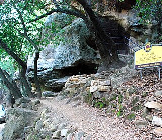
WChumash Painted Cave State Historic Park is a unit in the state park system of California, preserving a small sandstone cave adorned with rock art attributed to the Chumash people. Adjoining the small community of Painted Cave, the site is located about 2 miles (3.2 km) north of California State Route 154 and 11 miles (18 km) northwest of Santa Barbara. The 7.5-acre (3.0 ha) park was established in 1976.
 W
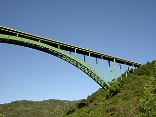
WThe Cold Spring Canyon Arch Bridge in the Santa Ynez Mountains links Santa Barbara, California with Santa Ynez, California. The bridge is signed as part of State Route 154.
 W
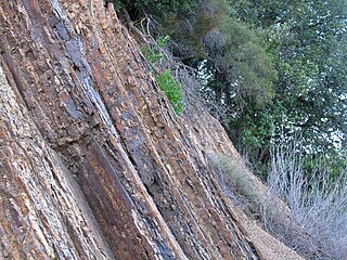
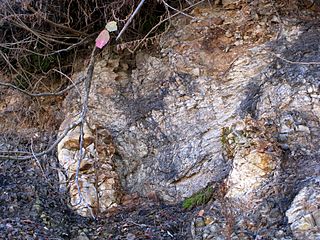
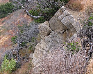
WThe Coldwater Sandstone is a sedimentary geologic unit of Eocene age found in Southern California, primarily in and south of the Santa Ynez Mountains of Santa Barbara County, and east into Ventura County. It consists primarily of massive arkosic sandstone with some siltstone and shale. Being exceptionally resistant to erosion, outcrops of the Coldwater form some of the most dramatic terrain on the south slope of the Santa Ynez Mountains, with immense white sculpted slabs forming peaks, hogback ridges, and sheer cliff faces.
 W
WThe Cozy Dell Shale is a geologic formation of middle Eocene age that crops out in the Santa Ynez Mountains and Topatopa Mountains of California, extending from north of Fillmore in Ventura County westward to near Point Arguello, north of Santa Barbara. Because the Cozy Dell easily weathers to a clay-rich soil, it crops out infrequently and generally forms dense stands of chaparral in saddles between peaks and ridges of the more resistant Matilija and Coldwater formations.
 W
WEriodictyon capitatum, the Lompoc yerba santa, is a rare evergreen shrub in the borage family. It is endemic to western Santa Barbara County, in California.
 W
WThe Espada Formation is a sedimentary rock formation widespread in Santa Barbara County, California. Of late Jurassic to Cretaceous age, the unit consists primarily of shale with some interbedded thin layers of sandstone, conglomerate, and limestone.
 W
WFritillaria ojaiensis is a rare species of fritillary lily known by the common name Ojai fritillary.
 W
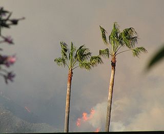
WThe Gap Fire was a fire that burned 9,443 acres (38.21 km2) of the Santa Ynez Mountains above Goleta, California between July 1 and July 28, 2008. The fire burned primarily on steep slopes above the community of Goleta. Dense brush that had not burned in over fifty years, coupled with steep terrain made the fire challenging for firefighters.
 W
WGaviota State Park is a state park of California, USA. It is located in southern Santa Barbara County, California, about 33 miles (53 km) west of the city of Santa Barbara. It extends from the Pacific coast to the crest of the Santa Ynez Mountains, and is adjacent to Los Padres National Forest. The 2,787-acre (1,128 ha) park was established in 1953.
 W
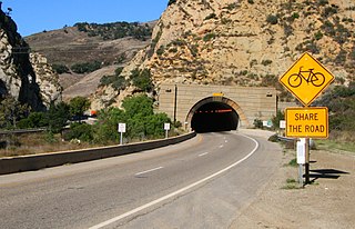
WThe Gaviota Tunnel is a tunnel on U.S. Route 101 completed in 1953 in the center of Gaviota State Park, 33 miles (53 km) northwest of Santa Barbara, California. It is 420 feet (130 m) long and 17.5 feet (5.3 m) tall. Only the northbound lanes of US 101 pass through it, as the southbound lanes descend from Gaviota Pass through a narrow canyon to the west of the tunnel. Because it is the only major route between the Santa Barbara County South Coast and the Santa Ynez Valley, bicycles are allowed through it. There is a rest area for both southbound and northbound lanes on the southern end of the tunnel, the southernmost one along U.S. Route 101.
 W
WHollister Ranch is 14,400 acres (58 km2) of fallow and fertile fields, mountains and valleys along the Pacific coast of California between Gaviota State Park and Point Conception. The area is some of the oldest known human settlements in the new world, the last native population of which was the Chumash. The Spanish Portolà expedition, the first European land explorers of California, traveled along its coast in 1769. It became part of the extensive Spanish land grant known as Rancho Nuestra Señora del Refugio, operated by the family of José Francisco Ortega from 1794.
 W
WThe Jalama Formation is a sedimentary rock formation widespread in southern Santa Barbara County and northern Ventura County, southern California. Of the Late Cretaceous epoch, the unit consists predominantly of clay shale with some beds of sandstone.
 W
WThe Jesusita Fire was a wildfire that started on May 5, 2009 in the hills of Santa Barbara, California in the western United States. By the time the fire was contained on May 18 it had burned 8,733 acres (35.34 km2), destroyed 80 homes and damaged 15 more before being 100% contained. The cause of the fire was ultimately traced to local contractors who had left gas cans and hot equipment unattended in dry brush after clearing part of the Jesusita Trail using a weed wacker without any permits or the permission of the landowner.
 W
WThe Juncal Formation is a prominent sedimentary geologic unit of Eocene age found in and north of the Santa Ynez Mountain range in southern and central Santa Barbara County and central Ventura County, California. An enormously thick series of sediments deposited over millions of years in environments ranging from nearshore to deep water, it makes up much of the crest of the Santa Ynez range north of Montecito, as well as portions of the San Rafael Mountains in the interior of the county. Its softer shales weather to saddles and swales, supporting a dense growth of brush, and its sandstones form prominent outcrops.
 W
WLa Cumbre Peak is a 3,997-foot (1,218 m) peak in the Santa Ynez Mountains north of Santa Barbara, California. Made up of boulders and slabs of the Matilija Sandstone amid groves of pine trees, it is the highest summit near to the city. Other peaks in the Santa Ynez Range are Santa Ynez Peak, 15 miles (24 km) to the west, and Divide Peak, 15 miles (24 km) to the east.
 W
WMar Y Cel or, more correctly, Mar i Cel is an open space preserve conserved by the Land Trust for Santa Barbara County, in Santa Barbara County, California, USA. Located in the Santa Ynez Mountains foothills above Montecito, Mar Y Cel is a 350-acre (1.4 km2) estate. It includes the notable "Tea Gardens", as well as the West Fork of Cold Springs Trail, a well used hiking trail.
 W
WThe Matilija Sandstone is a sedimentary geologic unit of Eocene epoch in the Paleogene Period, found in Santa Barbara and Ventura Counties in Southern California.
 W
WMission Canyon is a census-designated place and an unincorporated suburb of Santa Barbara, California, in Santa Barbara County, United States. The population was 2,381 at the 2010 census, down from 2,610 at the 2000 census.
 W
WNojoqui Falls is a seasonal waterfall in the Santa Barbara County, California park of the same name.
 W
WThe Painted Cave Fire was a devastating wildfire that burned in the Santa Ynez Mountains and the city of Santa Barbara, within Santa Barbara County, California.
 W
WPainted Cave is an unincorporated community of Santa Barbara County located in the Santa Ynez Mountains and is so named due to its proximity to Painted Cave State Historic Park. It is primarily served by Camino Cielo Road and California State Route 154, which link the community both to the nearby Santa Ynez Valley and Santa Barbara, California. The community is made up of roughly 100 homesteads, plus many outlying settlements. Painted Cave is the highest and largest of the inholdings within the Santa Ynez Mountains, and commands an impressive view- on clear days, all seven of the Channel Islands can often be seen. The community is primarily composed of irregular lots, and does not, except in the center of the community, conform to any sort of grid. Painted Cave sits atop a rough plateau, and includes the large Laurel Springs Ranch. The local terrain is extremely hilly, and numerous homes along Rim and Lookout roads approach or even overhang sheer cliffs.
 W
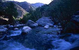
WPiru Creek is a major stream, about 71 miles (114 km) long, in northern Los Angeles County and eastern Ventura County, California. It is a tributary of the Santa Clara River, the largest stream system in Southern California that is still relatively natural.
 W
WRancho del Cielo, also known in its English translation as Sky's Ranch or Heaven's Ranch, is a 688-acre (1.075 sq mi)/278-hectare (2.78 km2) ranch located atop the Santa Ynez Mountain range northwest of Santa Barbara, California, United States. It served as a vacation home for President Ronald Reagan and First Lady Nancy Reagan.
 W
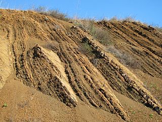
WThe Rincon Formation is a sedimentary geologic unit of Lower Miocene age, abundant in the coastal portions of southern Santa Barbara County, California eastward into Ventura County. Consisting of massive to poorly bedded shale, mudstone, and siltstone, it weathers readily to a rounded hilly topography with clayey, loamy soils in which landslides and slumps are frequent. It is recognizable on the south slopes of the Santa Ynez Mountains as the band at the base of the mountains which supports grasses rather than chaparral. Outcrops of the unit are infrequent, with the best exposures on the coastal bluffs near Naples, in the San Marcos Foothills, at the Tajiguas Landfill, and in road cuts. The geologic unit is notorious as a source of radon gas related to its high uranium content, released by radioactive decay.
 W
WSalsipuedes Creek is a 9.9 miles (15.9 km) long stream, flowing north to join the Santa Ynez River just southeast of Lompoc in Santa Barbara County, California. Salsipuedes Creek, along with its major tributary, El Jaro Creek, is the largest tributary to the lower Santa Ynez River, shortly before the river reaches the Pacific Ocean.
 W
WSan Marcos Pass is a mountain pass in the Santa Ynez Mountains in southern California.
 W
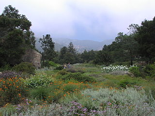
WThe Santa Barbara Botanic Garden is a 78-acre botanical garden, containing over 1,000 species of rare and indigenous plants. It is located in Mission Canyon, Santa Barbara, California, United States.
 W
WThe Santa Ynez River is one of the largest rivers on the Central Coast of California. It is 92 miles (148 km) long, flowing from east to west through the Santa Ynez Valley, reaching the Pacific Ocean at Surf, near Vandenberg Air Force Base and the city of Lompoc.
 W
WThe Sherpa Fire was a wildfire that burned in the Santa Ynez Mountains along the Gaviota Coast in the southwestern part of Santa Barbara County, California in June 2016. In a matter of hours the fire spread to over 1,400 acres (570 ha) as the fire was propelled by downslope sundowner winds. This offshore northerly wind contrasts with the more typical onshore flow and sent the fire down the canyons towards the ocean with gusts of over 35 miles per hour (56 km/h). The wildfire resulted in evacuations at two state beach campgrounds and some residences together with intermittent interruption of traffic on a state transportation route.
 W
WSkofield Park is a 35 acres (140,000 m2) natural open space preserve and city park located within Santa Barbara, California. Rattlesnake Canyon Park is located nearby, with both in the "front country" of the Santa Ynez Mountains.
 W
WThe Tea Fire, also known as the Montecito Tea Fire, was a wildfire that began on November 13, 2008, destroying 210 homes in the cities of Montecito and Santa Barbara, California in the United States of America. It was the first of several November 2008 wildfires that burned hundreds of homes from November 13–15, 2008. The Tea Fire ignited in the Cold Springs section of Montecito at approximately 17:50 PST on November 13, 2008. The fire started at a Mar Y Cel historic structure called the "Tea House" above Mountain Drive, giving the fire its name. Spreading rapidly, it was fanned by offshore winds, known as Sundowner winds that blow down the Santa Ynez Mountains, gusting up to 85 mph (113 km/h). These winds caused the fire to spread into the city of Santa Barbara. The fire was 40% contained on the 15th, 75% on the 16th, and by November 17, 2008 it was 95% contained after burning 1,940 acres, and on November 18, it was 100% contained.
 W
WThermopsis macrophylla is a species of flowering plant in the legume family known by the common names Santa Inez goldenbanner and Santa Ynez false-lupine.
 W
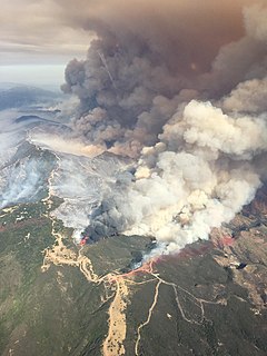
WThe Thomas Fire was a massive wildfire that affected Ventura and Santa Barbara Counties, and one of multiple wildfires that ignited in southern California in December 2017. It burned approximately 281,893 acres before being fully contained on January 12, 2018, making it the largest wildfire in modern California history at the time. It was surpassed by the Ranch Fire, part of the Mendocino Complex, in August 2018. The fire is currently the fifth-largest wildfire in modern California history, as of 2020. The fire was officially declared out on June 1, 2018, after more than two months in which no hotspots were detected. The Thomas Fire destroyed at least 1,063 structures, while damaging 280 others; and the fire caused over $2.2 billion in damages, including $230 million in suppression costs, becoming the seventh-most destructive wildfire in state history at the time. As of August 2020, the Thomas Fire is California's tenth-most destructive wildfire. Ventura's agriculture industry suffered at least $171 million in losses due to the Thomas Fire.
 W
WThe Vaqueros Formation is a sedimentary geologic unit primarily of Upper Oligocene and Lower Miocene age, which is widespread on the California coast and coastal ranges in approximately the southern half of the state. It is predominantly a medium-grained sandstone unit, deposited in a shallow marine environment. Because of its high porosity and nearness to petroleum source rocks, in many places it is an oil-bearing unit, wherever it has been configured into structural or stratigraphic traps by folding and faulting. Being resistant to erosion, it forms dramatic outcrops in the coastal mountains. Its color ranges from grayish-green to light gray when freshly broken, and it weathers to a light brown or buff color.
 W
WThe Whittier Fire was a wildfire in the Santa Ynez Mountains, south of Lake Cachuma, along Highway 154 in Santa Barbara County, California in the United States. The fire was reported on July 8, 2017, at 1:43 pm. Upon containment on July 28, the fire had burned a total of 18,430 acres (75 km2) and destroyed 16 homes.