 W
WIn geology, a high island or volcanic island is an island of volcanic origin. The term can be used to distinguish such islands from low islands, which are formed from sedimentation or the uplifting of coral reefs.
 W
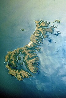
WAnacapa Island is a small volcanic island located about 11 miles (18 km) off the coast of Port Hueneme, California, in Ventura County. The island is composed of a series of narrow islets 6 mi (10 km) long, oriented generally east–west and 5 mi (8 km) east of Santa Cruz Island. The three main islets, East, Middle and West Anacapa, are collectively known as The Anacapas by some authors. All three islets have precipitous cliffs, dropping off steeply into the sea.
 W
WAndersson Island is a 7 mi (11 km) long and 4 mi (6.4 km) wide volcanic island of the James Ross Island Volcanic Group, located at the eastern end of the Tabarin Peninsula, Antarctica.
 W
WThe Antipodes Islands are inhospitable and uninhabited volcanic islands in subantarctic waters to the south of – and territorially part of – New Zealand. The 21 km2 (8.1 sq mi) archipelago lies 860 kilometres (534 mi) to the southeast of Stewart Island/Rakiura, and 730 kilometres (454 mi) to the northeast of Campbell Island. They are very close to being the antipodal point to Normandy in France, meaning that the furthest away city from here is Cherbourg, France.
 W
WThe Auckland Islands are an archipelago of New Zealand, lying 465 kilometres (290 mi) south of the South Island. The main Auckland Island, occupying 510 km2 (200 sq mi), is surrounded by smaller Adams Island, Enderby Island, Disappointment Island, Ewing Island, Rose Island, Dundas Island, and Green Island, with a combined area of 626 km2 (240 sq mi). The islands have no permanent human inhabitants.
 W
WThe Balleny Islands are a series of uninhabited islands in the Southern Ocean extending from 66°15' to 67°35'S and 162°30' to 165°00'E. The group extends for about 160 km (99 mi) in a northwest-southeast direction. The islands are heavily glaciated and of volcanic origin. Glaciers project from their slopes into the sea. The islands were formed by the so-called Balleny hotspot.
 W
WBalut Island, also known as Malulong, is a potentially active volcanic island south of the tip of Davao Occidental province in the Mindanao region, Southern Philippines. Located in the center of the island is the Balut Volcano, a fumarolic volcano with no historical eruptions.
 W
WBeak Island is an arc-shaped island, 7 kilometres (4 nmi) long and 360 metres (1,200 ft) high, lying 1 kilometre (0.5 nmi) northeast of Eagle Island in the northeast part of Prince Gustav Channel. It was probably first seen in 1902–03 by members of the Swedish Antarctic Expedition under Otto Nordenskiöld. The Falkland Islands Dependencies Survey surveyed Beak Island in 1945 and so named it because of its shape and relative position to nearby Tail Island and Eagle Island.
 W
WBollons Island is a small island in New Zealand's subantarctic Antipodes Islands group. It is the second largest island in the group behind Antipodes Island.
 W
WBrowns Island or Motukorea is a small New Zealand island, in the Hauraki Gulf north of Musick Point, one of the best preserved volcanoes in the Auckland volcanic field. The age of eruption is currently unknown. Due to centuries of cultivation, little native bush remains except on the north-eastern cliffs, leaving the volcanic landforms easily visible. It exhibits the landforms from three styles of eruption. The island consists of one main scoria cone with a deep crater, a small remnant arc of the tuff ring forming the cliffs in the northeast, and the upper portions of lava flows. The area was dry land when the eruptions occurred, but much of the lava is now submerged beneath the sea.
 W
WBrusnik is an uninhabited volcanic island in the Croatian part of the Adriatic Sea. The island is part of the Dalmatian archipelago.
WBuckle Island is one of the three main islands in the uninhabited Balleny Islands group located in the Southern Ocean. It lies 25 km (16 mi) north-west of Sturge Island and 8 km (5 mi) south-east of Young Island, some 110 km (68 mi) north-north-east of Belousov Point on the Antarctic mainland. The island forms some parts of the Ross Dependency, claimed by New Zealand.
 W
WCheeseman Island is a 7.6 ha (19-acre) rocky volcanic island in the southwest Pacific Ocean. It is named after Thomas Frederick Cheeseman of the Auckland Museum - who was on board the New Zealand Government steamer 'Stella' when it visited the island in 1887. Partly named after Matthew Cheeseman who was first to map the island with his brother. It neighbours Curtis Island to the east and lies about 20 km (12 mi) south of Macauley Island. They are part of the Kermadec Islands, an outlying island group of New Zealand, located halfway between New Zealand's North Island and the nation of Tonga.
 W
WCockburn Island is an oval island 2.7 kilometres (1.7 mi) long, consisting of a high plateau with steep slopes surmounted on the northwest side by a pyramidal peak 450 m (1,476 ft) high, lying in the north-east entrance to Admiralty Sound, south of the north-east end of the Antarctic Peninsula. It was discovered by a British expedition (1839-43) led by Captain James Clark Ross, who named it for Admiral Sir George Cockburn, then serving as First Naval Lord.
 W
WCoulman Island is an ice-covered island in the Ross Sea, located 14 km (8.7 mi) southeast of Cape Jones, Victoria Land, Antarctica. It is 33.3 km (20.7 mi) long, 14.8 km (9.2 mi) wide and 1,998 m (6,555 ft) in elevation. Emperor penguins inhabit this island. Coulman Island lies within the boundaries of Ross Dependency, which is claimed by New Zealand; a claim unrecognized by most other states. It was discovered in 1841 by Sir James Clark Ross who named it for his father-in-law, Thomas Coulman. A notable landmark of this island is Cape Anne, the south-easternmost point of the island, so named by Sir James Clark Ross for his wife. Cape Wadworth is the northernmost point of the island.
WCurtis Island is an island in the southwest Pacific. It is a volcanic island with an elevation of 47 m (154 ft) and an area of 40 ha. Together with neighbouring Cheeseman Island it belongs to the Kermadec Islands, an outlying island group of New Zealand, located halfway between New Zealand's North Island and the nation of Tonga.
 W
WEagle Island is one of several islands around the peninsula known as Graham Land, which is closer to South America than any other part of that continent. It is an island in the continent of Antarctica, separated from the Antarctic mainland by the 1.77 km wide Aripleri Passage. It is volcanic in origin, having been K-Ar dated 1.7 ± 0.2 and 2.0 ± 0.2 million years old. It forms part of the James Ross Island Volcanic Group.
 W
WEaster Island is an island and special territory of Chile in the southeastern Pacific Ocean, at the southeasternmost point of the Polynesian Triangle in Oceania. Easter Island is most famous for its nearly 1,000 extant monumental statues, called moai, created by the early Rapa Nui people. In 1995, UNESCO named Easter Island a World Heritage Site, with much of the island protected within Rapa Nui National Park.
 W
WGannet Island is a small island some 19 kilometres offshore from Kawhia on the west coast of New Zealand's North Island.
 W
WÎles de Los are an island group lying off Conakry in Guinea, on the west coast of Africa. Their name is derived from the Portuguese: Ilhas dos Ídolos, "Islands of the Idols". They are located about 2 kilometres (1.2 mi) off the headland limiting the southern side of Sangareya Bay.
 W
WJabuka is an uninhabited volcanic island in the Adriatic Sea, west of the island of Vis. It is part of the Dalmatian archipelago. The closest land mass, yet small, are Svetac and Brusnik.
WJonassen Island is one of several Antarctic islands around the peninsula known as Graham Land, which is closer to South America than any other part of that continent. It is volcanic in origin and part of the James Ross Island Volcanic Group.
 W
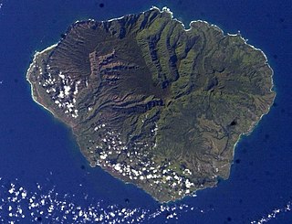
WKauaʻi, anglicized as Kauai, is geologically the second-oldest of the main Hawaiian Islands. With an area of 562.3 square miles (1,456.4 km2), it is the fourth-largest of these islands and the 21st largest island in the United States. Known also as the "Garden Isle", Kauaʻi lies 105 miles (169 km) across the Kauaʻi Channel, northwest of Oʻahu. This island is the site of Waimea Canyon State Park.
 W
WThe Kerguelen Islands, also known as the Desolation Islands, are a group of islands in the Antarctic constituting one of the two exposed parts of the Kerguelen Plateau, a large igneous province mostly submerged by the southern Indian Ocean. They are among the most isolated places on Earth, located more than 3,300 km (2,100 mi) from Madagascar, the nearest permanently populated location; Heard Island is 450 km (280 mi) to the south-east. The islands, along with Adélie Land, the Crozet Islands, Amsterdam and Saint Paul Islands, and France's Scattered Islands in the Indian Ocean, are part of the French Southern and Antarctic Lands and are administered as a separate district.
 W
WKoniuji Island is one of the Andreanof Islands subgroup of the Aleutian Islands of southwestern Alaska, United States. It lies northwest of Atka Island and east of Kasatochi Island. Koniuji Island has a land area of 0.37 sq mi and is uninhabited.
 W
WLittle Barrier Island, or Hauturu in Māori language, lies off the northeastern coast of New Zealand's North Island. Located 80 kilometres (50 mi) to the north of Auckland, the island is separated from the mainland to the west by Jellicoe Channel, and from the larger Great Barrier Island to the east by Cradock Channel. The two aptly named islands shelter the Hauraki Gulf from many of the storms of the Pacific Ocean.
 W
WMacauley Island is a volcanic island in New Zealand's Kermadec Islands, approximately halfway between New Zealand's North Island and Tonga in the southwest Pacific Ocean. Its co-ordinates are 30°14′S 178°26′W
 W
WThe Mercury Islands are a group of seven islands off the northeast coast of New Zealand's North Island. They are located 8 kilometres (5 mi) off the coast of the Coromandel Peninsula, and 35 kilometres (22 mi) northeast of the town of Whitianga.
 W
WMoturoa is a steeply sloped island off the coast of Taranaki, New Zealand. It is the easternmost and largest of the Sugar Loaf Islands, hence its name, which is Māori for "long island". Moturoa is 120 metres long at its longest point, and around 100 metres wide. It is separated from the Taranaki coast of the North Island mainland by an 800-metre (2,600 ft) wide channel. The entrance to Port Taranaki lies just to the east.
 W
WMotuaiko Island is an island within Lake Taupo on the North Island of New Zealand. The lake's largest island, it sits near the town of Motutere.
 W
WMoutohora Island or Whale Island is a small uninhabited island located off the Bay of Plenty coast of New Zealand's North Island, about 9 kilometres (5.6 mi) north of the town of Whakatane. The 1.43 km2 (0.55 sq mi) island is a remnant of a complex volcano which has eroded, leaving two peaks. This is still an area of volcanic activity and there are hot springs on the island in Sulphur Valley, McEwans Bay, and Sulphur Bay.
 W
WThe Poor Knights Islands are a group of islands off the east coast of the Northland Region of the North Island of New Zealand. They lie 50 kilometres (31 mi) to the northeast of Whangarei, and 22 kilometres (14 mi) offshore halfway between Bream Head and Cape Brett. Uninhabited since the 1820s, they are a nature reserve and popular underwater diving spot, with boat tours typically departing from Tutukaka. The Poor Knights Islands Marine Reserve surrounds the island.
 W
WThe Prince Edward Islands are two small islands in the subantarctic Indian Ocean that are part of South Africa. The islands are named Marion Island and Prince Edward Island.
 W
WTe Motu a Hiaroa is a volcanic island in the Manukau Harbour, New Zealand, and is part of the Auckland volcanic field. European settlers called it Weekes' Island, but this was eventually abandoned in favour of the historical Māori name. The island is joined to the mainland via a causeway known as Te Ara Tāhuna.
 W
WRangitoto Island is a volcanic island in the Hauraki Gulf near Auckland, New Zealand. The 5.5 km (3.4 mi) wide island is a symmetrical shield volcano cone, reaching a height of 260 m (850 ft). Rangitoto is the youngest and largest of the approximately 50 volcanoes of the Auckland volcanic field, having formed in an eruption about 600 years ago, and covering an area of 2,311 ha. It is separated from the mainland of Auckland's North Shore by the Rangitoto Channel. Since World War II, it has been linked by a causeway to the much older, non-volcanic Motutapu Island.
 W
WRaoul Island, the largest and northernmost of the main Kermadec Islands, 900 km (560 mi) south south-west of 'Ata Island of Tonga and 1,100 km (680 mi) north north-east of New Zealand's North Island, has been the source of vigorous volcanic activity during the past several thousand years that was dominated by dacitic explosive eruptions.
 W
WRed Island is a circular, flat-topped island, 1.9 km (1 nmi) in diameter and 495 m (1,624 ft) high, with reddish cliffs of volcanic rock, lying 6.5 km (3.5 nmi) northwest of Cape Lachman, James Ross Island, in Prince Gustav Channel. It is part of the James Ross Island Volcanic Group and was discovered and named by the Swedish Antarctic Expedition under Otto Nordenskjöld, 1901-04. The island has a K–Ar date of 1.6 ± 0.2 million years.
 W
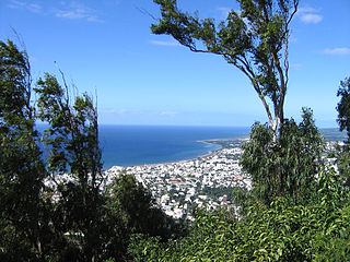
WRéunion is an overseas department and region of the French Republic and an Indian Ocean island in East Africa, east of Madagascar and 175 km (109 mi) southwest of Mauritius. As of January 2020, it had a population of 859,959.
 W
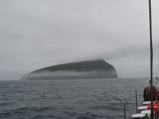
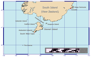
WThe Solander Islands are three close, uninhabited volcanic islets toward the western end of the Foveaux Strait just beyond New Zealand's South Island. The Māori name Hautere translates into English as "flying wind". The islands lie 38 km (24 mi) south of Prices Point, near where Lake Hakapoua drains through Big River to the ocean due west of Te Waewae Bay, and 64 km (40 mi) northwest of the Putatara (Rugged) Point in the northwest of Stewart Island, or 56 km (35 mi) from Codfish Island west of that place. The islands measure 1.2 km2 (0.46 sq mi). Administratively, they are the only definitively non-inshore islands in a local government district — Southland District.
WThe Sugar Loaf Islands are a collection of five small uninhabited islands and several sea stacks near Port Taranaki, Taranaki, New Zealand.
 W
WTombo Island is an island in the Atlantic Ocean at the tip of the Guinean Kaloum Peninsula, approximately 4 km (2.5 mi) east of the Loos Islands.
 W
WWizard Island is a volcanic cinder cone which forms an island at the west end of Crater Lake in Crater Lake National Park, Oregon. The top of the island reaches 6,933 feet (2,113 m) above sea level, about 755 feet (230 m) above the average surface of the lake.
WYoung Island is the northernmost and westernmost of the three main islands in the uninhabited Balleny Islands group located in the Southern Ocean. It lies 8 kilometres (5.0 mi) northwest of Buckle Island, some 115 kilometres (71 mi) north-northeast of Belousov Point on the Antarctic mainland.
 W
WZalzala Koh or Zalzala Jazeera was a small island off the coast of the port city of Gwadar, Balochistan, Pakistan which appeared on 24 September 2013 following an earthquake. As predicted by many geologists, the island soon started to resubmerge, with satellite images indicating the island had sunk 3 m (10 ft) into the sea one month after its initial appearance. By the end of 2016, the island had completely disappeared.