 W
WAkaroa is a small town on Banks Peninsula in the Canterbury region of the South Island of New Zealand, situated within a harbour of the same name. The name Akaroa is Kāi Tahu Māori for "Long Harbour", which would be spelled "Whangaroa" in standard Māori. The area was also named Port Louis-Philippe by French settlers after the reigning French king Louis Philippe I.
 W
WThe Aldermen Islands are a small group of rocky islets to the southeast of Mercury Bay in the North Island of New Zealand. They are located off the coast of the Coromandel Peninsula, 20 kilometres (12 mi) east of the mouth of the Tairua River.
 W
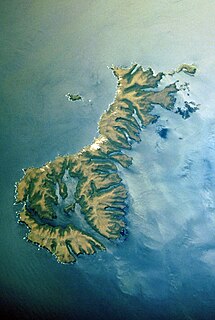
WThe Antipodes Islands are inhospitable and uninhabited volcanic islands in subantarctic waters to the south of – and territorially part of – New Zealand. The 21 km2 (8.1 sq mi) archipelago lies 860 kilometres (534 mi) to the southeast of Stewart Island/Rakiura, and 730 kilometres (454 mi) to the northeast of Campbell Island. They are very close to being the antipodal point to Normandy in France, meaning that the furthest away city from here is Cherbourg, France.
 W
WThe Auckland Islands are an archipelago of New Zealand, lying 465 kilometres (290 mi) south of the South Island. The main Auckland Island, occupying 510 km2 (200 sq mi), is surrounded by smaller Adams Island, Enderby Island, Disappointment Island, Ewing Island, Rose Island, Dundas Island, and Green Island, with a combined area of 626 km2 (240 sq mi). The islands have no permanent human inhabitants.
 W
WBollons Island is a small island in New Zealand's subantarctic Antipodes Islands group. It is the second largest island in the group behind Antipodes Island.
 W
WThe Bombay Hills are a range of hills to the south of Auckland, New Zealand. Though only a small and seemingly insignificant range of hills, they lie at the southern boundary of the Auckland region, and serve as a divide between Auckland and the Waikato region. There is a 19th-century settlement, Bombay, on the old main road south of Auckland, the Great South Road.
 W
WThe Brothers Volcano is a Pacific Ocean submarine volcano in the Kermadec Arc, 340 kilometres north east of New Zealand's Whakaari/White Island. Within its oval outline, which measures 13 km by 8 km, it contains a 3 km wide caldera with walls 300-500 m high. It is three times bigger than the White Island. A dacite dome rises 350 m from the caldera floor, with a smaller dome just to its northeast.
 W
WBrowns Island or Motukorea is a small New Zealand island, in the Hauraki Gulf north of Musick Point, one of the best preserved volcanoes in the Auckland volcanic field. The age of eruption is currently unknown. Due to centuries of cultivation, little native bush remains except on the north-eastern cliffs, leaving the volcanic landforms easily visible. It exhibits the landforms from three styles of eruption. The island consists of one main scoria cone with a deep crater, a small remnant arc of the tuff ring forming the cliffs in the northeast, and the upper portions of lava flows. The area was dry land when the eruptions occurred, but much of the lava is now submerged beneath the sea.
 W
WCampbell Island / Motu Ihupuku is an uninhabited subantarctic island of New Zealand, and the main island of the Campbell Island group. It covers 112.68 square kilometres (43.51 sq mi) of the group's 113.31 km2 (43.75 sq mi), and is surrounded by numerous stacks, rocks and islets like Dent Island, Folly Island, Isle de Jeanette-Marie, and Jacquemart Island, the latter being the southernmost extremity of New Zealand. The island is mountainous, rising to over 500 metres (1,640 ft) in the south. A long fjord, Perseverance Harbour, nearly bisects it, opening out to sea on the east coast.
 W
WCheeseman Island is a 7.6 ha (19-acre) rocky volcanic island in the southwest Pacific Ocean. It is named after Thomas Frederick Cheeseman of the Auckland Museum - who was on board the New Zealand Government steamer 'Stella' when it visited the island in 1887. Partly named after Matthew Cheeseman who was first to map the island with his brother. It neighbours Curtis Island to the east and lies about 20 km (12 mi) south of Macauley Island. They are part of the Kermadec Islands, an outlying island group of New Zealand, located halfway between New Zealand's North Island and the nation of Tonga.
 W
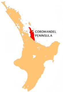
WThe Coromandel Peninsula on the North Island of New Zealand extends 85 kilometres north from the western end of the Bay of Plenty, forming a natural barrier protecting the Hauraki Gulf and the Firth of Thames in the west from the Pacific Ocean to the east. It is 40 kilometres wide at its broadest point. Almost its entire population lies on the narrow coastal strips fronting the Hauraki Gulf and the Bay of Plenty. In clear weather the peninsula is clearly visible from Auckland, the country's biggest city, which lies on the far shore of the Hauraki Gulf, 55 kilometres to the west. The peninsula is part of the Thames-Coromandel District of the Waikato region.
WCurtis Island is an island in the southwest Pacific. It is a volcanic island with an elevation of 47 m (154 ft) and an area of 40 ha. Together with neighbouring Cheeseman Island it belongs to the Kermadec Islands, an outlying island group of New Zealand, located halfway between New Zealand's North Island and the nation of Tonga.
 W
WGannet Island is a small island some 19 kilometres offshore from Kawhia on the west coast of New Zealand's North Island.
 W
WHauhungatahi is an eroded volcano at the southern end of the Taupo Volcanic Zone in New Zealand, located about 11 kilometres (7 mi) WNW of Mount Ruapehu. Although relatively little-known, at 1,521 metres (4,990 ft) Hauhungatahi is one of the highest volcanoes in New Zealand, exceeded in elevation by only Ruapehu, Taranaki/Egmont, and the Tongariro massif. The volcano is constructed atop an upfaulted block of Mesozoic marine sediments. The age of the erupted andesite lava is about 900,000 years, making Hauhungatahi more than three times as old as the neighboring Ruapehu.
 W
WKaikohe Hill is a 282 m high basaltic scoria cone, in the Kaikohe-Bay of Islands volcanic field in New Zealand. It is on the western edge of the town of Kaikohe.
 W
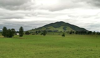
WKakepuku (Kakipuku-o-kahurere) rises from the plain between the Waipa and Puniu rivers, about 3 km (2 mi) NW of Te Kawa and 8 km (5 mi) SW of Te Awamutu in the Waikato region of New Zealand's North Island.
 W
WThe 2012 Kermadec Islands eruption was a major undersea volcanic eruption that was produced by the previously little-known Havre Seamount near the L'Esperance and L'Havre Rocks in the Kermadec Islands of New Zealand. The large volume of low density pumice produced by the eruption accumulated as a large area of floating pumice, a pumice raft, that was originally covering a surface of 400 square kilometres, spread to a continuous float of between 19,000 and 26,000 square kilometres and within three months dispersed to an area of more than twice the size of New Zealand.
 W
WLake Okataina is the northernmost and largest of four smaller lakes lying between Lake Rotorua and Lake Tarawera in the Bay of Plenty region of New Zealand's North Island. The others are Lake Rotokakahi, Lake Tikitapu, and Lake Okareka. All lie within the Okataina caldera, along its western edge.
 W
WLyttelton Harbour / Whakaraupō is one of two major inlets in Banks Peninsula, on the coast of Canterbury, New Zealand; the other is Akaroa Harbour on the southern coast.
 W
WMacauley Island is a volcanic island in New Zealand's Kermadec Islands, approximately halfway between New Zealand's North Island and Tonga in the southwest Pacific Ocean. Its co-ordinates are 30°14′S 178°26′W
 W
WMount Manaia is a dominant landmark approximately 30 kilometres southeast of Whangarei city on the Whangarei Heads peninsula.
 W
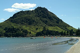
WMount Maunganui, or Mauao, commonly known by locals as The Mount, is an extinct volcanic cone at the end of a peninsula and the town of Mount Maunganui, by the eastern entrance to the Tauranga Harbour in New Zealand. It is considered very important and tapu (sacred) by the local Māori iwi, featuring extensively in local mythology. It is also of significant historical value. The summit is 232 metres above sea level.
 W
WMaungatautari is a mountain, rural community and ecological area near Cambridge in the Waikato region in New Zealand's central North Island.
 W
WThe Mercury Islands are a group of seven islands off the northeast coast of New Zealand's North Island. They are located 8 kilometres (5 mi) off the coast of the Coromandel Peninsula, and 35 kilometres (22 mi) northeast of the town of Whitianga.
 W
WMonowai is a volcanic seamount to the north of New Zealand. It is formed by a large caldera and a volcanic cone just south-southeast from the caldera. The volcanic cone rises to depths of up to 100 metres (330 ft) but its depth varies with ongoing volcanic activity, including sector collapses and the growth of lava domes. The seamount and its volcanism were discovered after 1877, but only in 1980 was it named "Monowai" after a research ship of the same name.
 W
WMoturoa is a steeply sloped island off the coast of Taranaki, New Zealand. It is the easternmost and largest of the Sugar Loaf Islands, hence its name, which is Māori for "long island". Moturoa is 120 metres long at its longest point, and around 100 metres wide. It is separated from the Taranaki coast of the North Island mainland by an 800-metre (2,600 ft) wide channel. The entrance to Port Taranaki lies just to the east.
WNgongotahā is a town on the western shores of Lake Rotorua in New Zealand's North Island. It is 10 kilometers northwest of Rotorua city, and is often regarded as an outer suburb of the larger centre. Its population was 4,107 in the 2013 census.
 W
WMount Ruapehu is an active stratovolcano at the southern end of the Taupo Volcanic Zone in New Zealand. It is 23 kilometres (14 mi) northeast of Ohakune and 23 km (14 mi) southwest of the southern shore of Lake Taupo, within Tongariro National Park. The North Island's major ski resorts and only glaciers are on its slopes.
 W
WMount Tarawera is a volcano on the North Island of New Zealand. Located 24 kilometres southeast of Rotorua, it consists of a series of rhyolitic lava domes that were fissured down the middle by an explosive basaltic eruption in 1886. This eruption was one of New Zealand's largest historical eruptions, and killed an estimated 120 people. The fissures run for about 17 kilometres northeast-southwest.
 W
WMoutohora Island or Whale Island is a small uninhabited island located off the Bay of Plenty coast of New Zealand's North Island, about 9 kilometres (5.6 mi) north of the town of Whakatane. The 1.43 km2 (0.55 sq mi) island is a remnant of a complex volcano which has eroded, leaving two peaks. This is still an area of volcanic activity and there are hot springs on the island in Sulphur Valley, McEwans Bay, and Sulphur Bay.
 W
WNorth Cape is located at the northern end of the Northland Peninsula in the North Island of New Zealand. It is the northeastern tip of the Aupouri Peninsula and lies 30 kilometres (19 mi) east and 3 kilometres (1.9 mi) north of Cape Reinga. The name North Cape is sometimes used to refer just to the cape that is known in Māori as Otou and which overlooks Murimotu Island, and sometimes just to the eastern point of Murimotu Island. It is also used to refer to the whole larger headland stretching about five km from Murimotu Island westwards to Kerr Point (Ngatuatata) and including the Surville Cliffs. This wider North Cape, and specifically the Surville Cliffs, is the northernmost point of mainland New Zealand, being about three km further north than Cape Reinga. This article covers the wider North Cape. Statistics New Zealand uses a much larger statistical area called North Cape, extending south to the Houhora Heads in the 2018 New Zealand census. That area is covered by the article on Aupouri Peninsula.
 W
WThe Otago Peninsula is a long, hilly indented finger of land that forms the easternmost part of Dunedin, New Zealand. Volcanic in origin, it forms one wall of the eroded valley that now forms Otago Harbour. The peninsula lies south-east of Otago Harbour and runs parallel to the mainland for 20 km, with a maximum width of 9 km. It is joined to the mainland at the south-west end by a narrow isthmus about 1.5 km wide.
 W
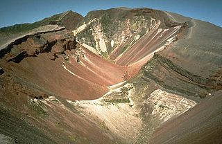
WMount Pihanga is a 1,326 metres (4,350 ft) volcanic peak in the North Island Volcanic Plateau, located to the north of Mount Tongariro, between Tongariro and Lake Taupo. Lake Rotoaira lies to the south-west of Pihanga, and the smaller Lake Rotopounamu is situated on the south-western flank of the volcano, near Te Ponanga Saddle. Mt. Pihanga and Lake Rotopounamu are part of the 5,129ha Pihanga Scenic Reserve, which in 1975 was added to the Tongariro National Park. Mt. Pihanga appears to have a large crater, but this is in fact the result of erosion, and the "crater" quickly narrows into a steep gorge.
 W
WThe Poor Knights Islands are a group of islands off the east coast of the Northland Region of the North Island of New Zealand. They lie 50 kilometres (31 mi) to the northeast of Whangarei, and 22 kilometres (14 mi) offshore halfway between Bream Head and Cape Brett. Uninhabited since the 1820s, they are a nature reserve and popular underwater diving spot, with boat tours typically departing from Tutukaka. The Poor Knights Islands Marine Reserve surrounds the island.
 W
WTe Motu a Hiaroa is a volcanic island in the Manukau Harbour, New Zealand, and is part of the Auckland volcanic field. European settlers called it Weekes' Island, but this was eventually abandoned in favour of the historical Māori name. The island is joined to the mainland via a causeway known as Te Ara Tāhuna.
 W
WPutauaki is a dacite volcanic cone in the Bay of Plenty Region of New Zealand. Located 50 km east of Rotorua and three kilometres east of Kawerau, it is the easternmost vent of the Okataina volcanic centre, within the Taupo Volcanic Zone. The mountain rises to 820 m above sea level, and is visible from the waters of the Bay of Plenty, 30 km to the north. Every year a King of the Mountain race is run on Putauaki as part of the international King of the Mountain series, and proceeds are donated to charity.
 W
WRaoul Island, the largest and northernmost of the main Kermadec Islands, 900 km (560 mi) south south-west of 'Ata Island of Tonga and 1,100 km (680 mi) north north-east of New Zealand's North Island, has been the source of vigorous volcanic activity during the past several thousand years that was dominated by dacitic explosive eruptions.
WRunaruna Mud Volcano is considered a national geological place of interest in New Zealand. It is located just southwest of Broadwood on private property.
 W
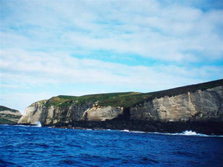
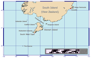
WThe Solander Islands are three close, uninhabited volcanic islets toward the western end of the Foveaux Strait just beyond New Zealand's South Island. The Māori name Hautere translates into English as "flying wind". The islands lie 38 km (24 mi) south of Prices Point, near where Lake Hakapoua drains through Big River to the ocean due west of Te Waewae Bay, and 64 km (40 mi) northwest of the Putatara (Rugged) Point in the northwest of Stewart Island, or 56 km (35 mi) from Codfish Island west of that place. The islands measure 1.2 km2 (0.46 sq mi). Administratively, they are the only definitively non-inshore islands in a local government district — Southland District.
WThe Sugar Loaf Islands are a collection of five small uninhabited islands and several sea stacks near Port Taranaki, Taranaki, New Zealand.
 W
WThe Tama Lakes are two crater lakes in New Zealand's Tongariro National Park. They fill two of a series of explosion craters on the Tama Saddle between Mount Ruapehu and Mount Ngaruahoe.
 W
WTe Ahuahu is a 373 m high basaltic scoria cone, in the Kaikohe-Bay of Islands volcanic field in New Zealand.
 W
WTe Paepae o Aotea, also known the Volkner Rocks, are a group of andesitic rock stacks and pinnacles located 5 kilometres (3.1 mi) northwest of Whakaari/White Island in New Zealand's Bay of Plenty. They reach 113 metres above sea level, while the saddle separating them from Whakaari/White Island is over 200 metres deep.
 W
WTe Tātua-a-Riukiuta is a volcano in Three Kings, New Zealand that erupted 28,500 years ago. The volcano had three prominent peaks and a number of smaller peaks until most of them were quarried away, leaving a sole remaining large peak.