 W
WThis is a list of mountains in Cabo Verde:
 W
WPico de Alberto is a mountain in the eastern part of São Nicolau island in Cape Verde. Its elevation is 598 m. The mountain's summit is located south of the village Juncalinho.
 W
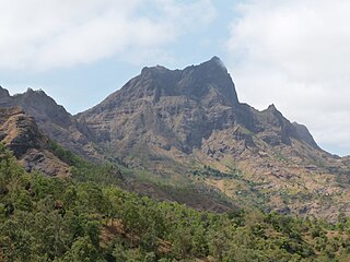
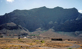
WPico de Antónia is a mountain located in the central part of the island of Santiago in Cape Verde. At 1,392 m (4,567 ft), it is the highest point of the island. The mountain is part of the protected area Parque Natural da Serra do Pico de Antónia. The towns Picos and Assomada lie close to the mountain. The Serra do Pico da Antónia has been identified by BirdLife International as an Important Bird Area.
 W
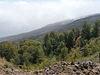
WThe Serra do Pico de Antónia is a mountain range in the centre of the island of Santiago in the Cape Verde archipelago. It contains the Pico de Antónia, at 1,392 m (4,567 ft) the highest point of the island. It is protected as a natural park,, covering 28.73 km2 (11.09 sq mi). The natural park covers the connected mountain ranges of Serra do Pico de Antónia and of Rui Vaz.
 W
WMorro de Areia Nature Reserve is a nature reserve covering the southwestern coast of the island of Boa Vista in Cape Verde. It takes its name from the hill Morro de Areia, 167 m (548 ft) elevation. The natural reserve covers 21.31 km2 of land area, and stretches along the coast from the Praia de Chaves in the north to the Praia de Santa Monica in the south. The reserve includes a 300 m wide marine protection zone, an additional 4.36 km2.
 W
WMonte Batalha is a mountain in the island of Maio in Cape Verde. Its elevation is 294 m. It is situated 4 km southeast of Calheta and 8 km northeast of the island capital Porto Inglês.
WMonte Bissau is a mountain in the central part of the island of São Nicolau in Cape Verde. It is situated 3 km southwest of Belém and 6 km east of the island capital Ribeira Brava. Its elevation is 615 m.
 W
WBordeira is a semicircular mountain in the middle of the island Fogo. It is a crater rim, up to 1 km high, formed by a prehistoric collapse of the volcano Pico do Fogo. At a maximum elevation of 2,692 metres (8,832 ft), it is the second highest point in the nation behind Pico do Fogo. The name literally means the "border". It forms part of Fogo Natural Park. Opening to the east, it effectively protects the northern, western and southern part of the island against lava flows from the volcano. The settlement Chã das Caldeiras lies at the foot of Bordeira, in the caldera. The east side of the Bordeira cliff is much steeper than the west side.
WMonte Caçador and Pico Forcado Protected Countryside is a protected area covering 3,357 hectares (12.96 sq mi) of land in the eastern part of the island of Boa Vista in Cape Verde. It is the most important mountain formation on the island, but not the highest.
WCagarral is a mountain in the northeastern part of the island of Sal in Cape Verde. It is located near the east coast, 2 km northeast of Pedra de Lume and 6 km east of the island capital Espargos. To its east is the headland Ponta Trás de Cagarral. Together with the mountain and the saltpans to the west, it is a protected area as a protected landscape.
WCagarral is a mountain in the northeastern part of the island of Sal in Cape Verde. It is located near the east coast, 2 km northeast of Pedra de Lume and 6 km east of the island capital Espargos. To its east is the headland Ponta Trás de Cagarral. Together with the mountain and the saltpans to the west, it is a protected area as a protected landscape.
 W
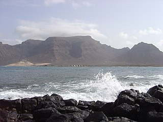
WCaixa is a mountain in the southern part of the island of São Vicente.It is situated 7 km south of the city centre of Mindelo. Its elevation is 535 metres (1,755 ft).
 W
WMonte Cara is a mountain in western part of the island of São Vicente, Cape Verde. Its elevation is 490 m. It resembles a human face looking at the sky, hence its name, which means "face mountain". It is a landmark of the city of Mindelo, from which it can be seen across Porto Grande Bay.
 W
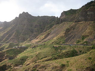
WTope de Coroa is a mountain on the island of Santo Antão's, Cape Verde. At 1,979 m elevation, it is the highest point of the island. It is in the western part of the island, 25 km west of the island capital Porto Novo. The mountain is entirely of volcanic origin. The area is the source of several streams including Ribeira de Monte Trigo which flows westward to Monte Trigo.
 W
WCova is a volcanic caldera in the eastcentral part of the island of Santo Antão in Cape Verde. It is situated at the southwestern end of the municipality of Paul. Its lowest point is 1,166 meters, and the highest point of the crater rim is about 1,500 m. The diameter of the caldera is about 1.0 km. It forms a part of Cova-Paul-Ribeira da Torre Natural Park. The Cova formation dates from between 1.4 million and 700,000 years ago.
 W
WPico da Cruz is a mountain in the eastern part of the island of Santo Antão. Its elevation is 1585 m. It is 5 km southwest of the town Pombas (Paul). It gives its name to the nearby village of Pico da Cruz, part of the municipality of Paul. Pico da Cruz is part of the protected area Cova-Paul-Ribeira da Torre Natural Park.
 W
WMonte Curral is a hill in the city of Espargos, on the island of Sal, Cape Verde. Its elevation is 109 meters. On the summit there is an air control tower for the nearby Amílcar Cabral International Airport, as well as several telecommunication masts.
 W
WMonte Estância is a mountain in the southeastern part of the island Boa Vista in Cape Verde. At 387 m elevation, it is the island's highest point. It is located 4 km from the Atlantic coast and 23 km southeast of the island capital Sal Rei. It is part of a protected natural space under the statute of natural monument, which covers 739 ha.
 W
WRocha Estância is a mountain in the southwestern part of the island Boa Vista in Cape Verde, east of the village of Povoação Velha. Its elevation is 357 meters. It is part of a protected area covering 253 ha. The Our Lady of Conception church is located at the western foot of the mountain.
WPico do Fogo [ˈpiku du ˈfoɡu] is the highest peak of Cape Verde and West Africa, rising to 2,829 metres (9,281 ft) above sea level. It is an active stratovolcano lying on the island of Fogo. The main cone last erupted in 1680, causing mass emigration from the island. A subsidiary vent erupted in 1995. The only deadly eruption was in 1847 when earthquakes killed several people.
 W
WMonte Fontainhas is a volcanic mountain in the middle of Brava island in Cape Verde. At 976 m elevation, it is the highest point of the island. Rock types are made up of phonolite and ignimbrite. The mountainous centre of the island is often covered with clouds, which feed numerous springs, as was already observed by the 19th century traveller Armand d'Avezac.
WMonte Caçador and Pico Forcado Protected Countryside is a protected area covering 3,357 hectares (12.96 sq mi) of land in the eastern part of the island of Boa Vista in Cape Verde. It is the most important mountain formation on the island, but not the highest.
WMonte António Gomes is a mountain in the northeastern part of the island of São Vicente, Cape Verde. Its elevation is 362 meters. It is 1.6 km north of Monte Verde, 2.3 km southeast of the village Salamansa and 6 km east of the city centre of Mindelo.
 W
WMonte Gordo is a mountain on the island of São Nicolau, Cape Verde. At 1,312 m elevation, it is the island's highest point. It is situated in the western part of the island, 6 km west of the island capital Ribeira Brava. The mountain is of volcanic origin, less than 1 million years old. The boundary of the municipalities Tarrafal de São Nicolau and Ribeira Brava runs over the mountain. It is part of the Monte Gordo Natural Park.
 W
WMonte Graciosa is a mountain in the northern part of the island of Santiago in Cape Verde. It lies 2.5 km north of the town of Tarrafal, overlooking the Baía de Tarrafal. Its elevation is 643 m. Towards the west it ends in the headland of Ponta Preta. It is part of a larger proposed natural park. The mountain is of volcanic origin, composed of phonolite and rich in feldspar and olivine.
 W
WMonte Grande is a mountain in the northern part of the island of Sal in Cape Verde. It is situated 8 km northeast of the island capital Espargos. At 406 m elevation, it is the highest point of the island. It is a protected landscape because of its geological value; the protected area covers 1,309 ha. There are pillow lava formations on the coast.
WGudo de Cavaleiro is a mountain in the middle of the island Santo Antão in Cape Verde. Its elevation is 1,810 meters. Part of the eastern plateau of Santo Antão, it lies directly south of the Moroços natural park. Nearby places are the villages Alto Mira to the west and Lagoa to the east. The mountain lies on the border of the municipalities Ribeira Grande and Porto Novo.
 W
WMadeiral or Monte Madeiral is a mountain in the southeastern part of the island of São Vicente, Cape Verde. Its elevation is 680 meters. The village Madeiral, part of the settlement Ribeira de Calhau, lies at its northern foot.
 W
WSerra Malagueta is a mountain range located in the northern part of the island of Santiago, Cape Verde. At 1064 m elevation, it is highest point of northern Santiago. The mountain range is protected as the Serra Malagueta Natural Park, that was established on February 24, 2005 and covers 774 hectares. The natural park is situated in the municipalities Tarrafal, São Miguel and Santa Catarina. The summit is in São Miguel, south of the Ribeira Principal valley. The Serra Malagueta formation is of volcanic origin, and was formed between 2.9 and 2.4 million years ago.
WMonte Montona is a low mountain in the western part of the island of São Vicente, Cape Verde. Its elevation is 242 m. It is situated 4 km northeast of São Pedro and 6 km southwest of the island capital Mindelo.
 W
WMorrinho de Açúcar is a small hill in the northern part of the island of Sal in Cape Verde. It is situated 1 km from the north coast and 8 km north of the island capital Espargos. It is a remnant of a volcanic phonolitic chimney, surrounded by a vast plain. It is protected as a natural monument.
 W
WSerra Negra is a hill in the southeastern part of the island of Sal in Cape Verde. Its maximum elevation is 104 m, the highest point in southern Sal. It stretches for about 2.5 km along the east coast of the island, between the headland Ponta da Fragata in the south and the Ponta do Morrinho Vermelho in the north. The nearest settlement is Murdeira, to the west. The mountain forms part of a protected area as a nature reserve, important as nesting area for seabirds and turtles. The nature reserve covers 3.31 km2 (1.28 sq mi) of land and 22.96 km2 (8.86 sq mi) of ocean.
WMorro Negro is a hill located near the east coast of the island of Boa Vista, Cape Verde. Its elevation is 156 m. The nearest village is Cabeça dos Tarrafes, 5.5 km to the northwest.
WMonte Penoso is a mountain on the island of Maio, Cape Verde. At 436 m elevation, it is the island highest point. It is situated in the eastern part of the island, 3 km southwest of Pedro Vaz and 13 km northeast of the island capital Porto Inglês. The mountain is of volcanic origin. It is part of the protected landscape Monte Penoso and Monte Branco, which covers 11.17 km2 (4.31 sq mi).
 W
WRabo de Junco is a hill on the west coast of the island of Sal in Cape Verde. It is situated at the northern end of the Baía da Murdeira, 8 kilometres (5.0 mi) southwest of the island capital Espargos. Its steep eroded south face towards the bay is an important nesting area for birds. Rabo de Junco and the surrounding 154 hectares are protected as a nature reserve. It was mentioned as Rabadyunk in the 1747 map by Jacques-Nicolas Bellin. To its west lies the uninhabited islet Ilhéu Rabo de Junco.
 W
WMonte Santo António is a mountain in the southwestern part of the island Boa Vista in Cape Verde. At 379 m (1,243 ft) elevation, it is the island's second highest point. Like Rocha Estância and Monte Estância, it rises steeply from the surrounding plains. It is part of a protected natural area under the statute of natural monument, covering 459 hectares.
WMonte São João is a low mountain in the central part of the island of São Vicente, Cape Verde. Its elevation is 154 m. It is situated 3 km southwest of the city centre of Mindelo.
WMonte Tchota is a mountain located in the central part of Santiago Island in Cape Verde. Its elevation is 1,041 m. It is part of the Serra do Pico de Antónia Natural Park, and lies 1.5 km southeast of Pico de Antónia, the highest point of the island. The village Rui Vaz lies 3 km to the east.
 W
WRibeira da Torre is a torrential stream in the northeastern part of the island of Santo Antão in Cape Verde. Its source is in the mountains north of the Cova crater, near the locality Rabo Curto. It flows to the north through the settlements Xoxo, Fajã Domingas Benta and Lugar de Guene. In the city Ribeira Grande it flows into the river Ribeira Grande, just upstream of its outflow into the Atlantic Ocean. Its upper valley is part of the protected area Cova-Paul-Ribeira da Torre Natural Park. There is small-scale agriculture in the valley, producing sugar cane, coffee, yam, banana, papaya and mango.
WMonte das Vacas is a mountain located in the southeastern part of the island of Santiago, Cape Verde. It is 2 km south of Ribeirão Chiqueiro and 8 km of the city centre of the capital Praia. Its elevation is 437 meters. It is of volcanic origin and was formed between 1.1 and 0.7 million years ago.
 W
WMonte Velha is a peak in the northeastern part of the island of Fogo in Cape Verde. Its elevation is 1,482 m. It is a subpeak of the Pico do Fogo volcano, located at the northeastern end of the crater rim. It lies within the municipality of Mosteiros, 4 km southwest of the city centre. Its forest is a protected area, part of the larger Fogo Natural Park.
WPico do Vento is a mountain in the eastern part of the island of São Vicente. It is situated south of the Ribeira do Calhau valley, 12 km southeast of the island capital Mindelo.
 W
WMonte Verde is a mountain in the eastern part of the island of São Vicente, Cape Verde. At 744 m elevation, it is the island's highest point. The mountain is located 6 km (4 mi) east of the city centre of Mindelo.
 W
WViana is a low volcano in the southeastern part of the island of São Vicente, Cape Verde. Its elevation is 163 metres (535 ft). It is situated 3 kilometres (2 mi) south of Calhau and 14 kilometres (9 mi) southeast of the island capital Mindelo.
WVigia is a low mountain in the northwestern part of the island of Boa Vista, Cape Verde. Its elevation is 146 m. It is situated 4 km north of the island capital Sal Rei, and 2 km south of the headland Ponta do Sol. It is part of the Ponta do Sol Nature Reserve covering 467 hectares of land and sea.