 W
WSan Isabel National Forest is located in central Colorado. The forest contains 19 of the state's 53 fourteeners, peaks over 14,000 feet (4,267 m) high, including Mount Elbert, the highest point in Colorado.
 W
WAgnes Vaille Falls is a waterfall on the southern slopes of Mount Princeton just above Chalk Creek in San Isabel National Forest, Chaffee County, Colorado, United States. The falls has been a popular half mile hike from county road 162 near Chalk Lake.
 W
WMount Antero is the highest summit of the southern Sawatch Range of the Rocky Mountains of North America. The prominent 14,276-foot (4351.4 m) fourteener is located in San Isabel National Forest, 12.2 miles (19.6 km) southwest by south of the Town of Buena Vista in Chaffee County, Colorado, United States. The mountain is named in honor of Chief Antero of the Uintah band of the Ute people.
 W
WBishop Castle is an "elaborate and intricate" "one-man project" named after its constructor, Jim Bishop, that has become a roadside attraction in central Colorado.
 W
WBlanca Peak is the fourth highest summit of the Rocky Mountains of North America and the U.S. state of Colorado. The ultra-prominent 14,351-foot (4,374 m) peak is the highest summit of the Sierra Blanca Massif, the Sangre de Cristo Range, and the Sangre de Cristo Mountains. The fourteener is located 9.6 miles (15.5 km) north by east of the Town of Blanca, on the drainage divide separating Rio Grande National Forest and Alamosa County from the Sangre de Cristo Land Grant and Costilla County. The summit is the highest point of both counties and the entire drainage basin of the Rio Grande. Below the steep North Face of Blanca Peak two live Glaciers once developed, until extinction sometime after 1903. North & South Blanca Glaciers were located at 37° 35N.,longitude 105° 28W. Blanca Peak is higher than any point in the United States east of its longitude.
WMount Blaurock is a high mountain summit of the Collegiate Peaks in the Sawatch Range of the Rocky Mountains of North America. The 13,623-foot (4,152 m) thirteener is located in San Isabel National Forest, 21.1 miles (33.9 km) northwest by west of the Town of Buena Vista in Chaffee County, Colorado, United States. Mount Blaurock was named in honor of Carl Blaurock, a co-founder of the Colorado Mountain Club and one of the first two persons to climb all of Colorado's fourteeners.
 W
WBrowns Canyon National Monument is a 21,586 acres (87 km2) national monument in Chaffee County, Colorado that was designated as such by President Barack Obama under the Antiquities Act on February 19, 2015. The site will be centered along the Arkansas River between Buena Vista and Salida. Browns Canyon is the most popular destination for whitewater rafting in the country, and is also known for its fishing and hiking. The monument will provide habitat protection for bighorn sheep, peregrine falcons, elk, and golden eagles.
 W
WThe Buffalo Peaks Wilderness is a U.S. Wilderness Area located in San Isabel and Pike National Forests in central Colorado. The 43,410-acre (175.7 km2) wilderness was named after two highly eroded volcanic mountains, East Buffalo Peak and West Buffalo Peak, in the Mosquito Range and was established in 1993. The wilderness contains Colorado's largest herd of bighorn sheep.
WBushnell Peak is a prominent mountain summit in the Sangre de Cristo Range of the Rocky Mountains of North America. The 13,110-foot (3,996 m) thirteener is located 7.2 miles (11.6 km) north-northeast of the community of Villa Grove, Colorado, United States, on the drainage divide separating Rio Grande National Forest and Saguache County from San Isabel National Forest and Fremont County. Bushnell Peak is the highest point in Fremont County.
WCalifornia Peak is a high mountain summit in the Sangre de Cristo Range of the Rocky Mountains of North America. The 13,855-foot (4,223 m) thirteener is located on the Sierra Blanca Massif, 12.1 miles (19.5 km) north of the Town of Blanca, Colorado, United States, on the drainage divide separating in Rio Grande National Forest and Alamosa County from San Isabel National Forest and Huerfano County.
 W
WCarbonate Mountain is a high mountain summit in the southern Sawatch Range of the Rocky Mountains of North America. The 13,670-foot (4,167 m) thirteener is located in San Isabel National Forest, 5.4 miles (8.7 km) north of the community of Garfield in Chaffee County, Colorado, United States.
WCasco Peak is a high mountain summit in the Sawatch Range of the Rocky Mountains of North America. The 13,915-foot (4,241 m) thirteener is located on the Elbert Massif in San Isabel National Forest, 3.8 miles (6.1 km) east of Independence Pass in Lake County, Colorado, United States.
WChalk Lake is a small lake in Chaffee County, Colorado, United States adjacent to Chalk Creek in San Isabel National Forest. The lake and surrounding area is a day-use area along road 162 across Chalk Creek from the Chalk Creek Campground, and a fee is charged for use of the lake. Chalk Lake is directly north of Mount Antero and directly south of Mount Princeton. The Denver, South Park and Pacific Railroad grade is above the south side of the lake below Mount Antero.
WClinton Peak is a high mountain summit in the Mosquito Range of the Rocky Mountains of North America. The 13,864-foot (4,226 m) thirteener is located 2.1 miles (3.3 km) east of Fremont Pass, Colorado, United States, on the Continental Divide separating San Isabel National Forest and Lake County from Pike National Forest and Park County.
 W
WThe Collegiate Peaks Wilderness is a 168,000-acre (680 km2) area located in central Colorado between Leadville and Buena Vista to the east and Aspen to the west and Crested Butte to the southwest. Most of the area is in the San Isabel and Gunnison National Forests, with a smaller area in the White River National Forest southeast of Aspen. Most of the area is in northwest Chaffee County with smaller portions in Gunnison, Pitkin, and Lake counties.
 W
WCronin Peak is a high mountain summit in the southern Sawatch Range of the Rocky Mountains of North America. The 13,877-foot (4,230 m) thirteener is located in San Isabel National Forest, 12.9 miles (20.8 km) southwest by west of the community of Nathrop in Chaffee County, Colorado, United States. Cronin Peak was named in honor of Mary Cronin, who in 1934 become the first woman to climb all 53 Colorado fourteeners.
 W
WMount Democrat is a high mountain summit in the Mosquito Range of the Rocky Mountains of North America. The 14,155-foot (4,314 m) fourteener is located 5.4 miles (8.7 km) northwest of the Town of Alma, Colorado, United States, on the Continental Divide separating San Isabel National Forest and Lake County from Pike National Forest and Park County.
 W
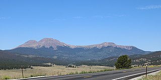
WEast Spanish Peak is a prominent mountain summit that is the lower of the two Spanish Peaks in the Rocky Mountains of North America. The 12,688-foot (3,867 m) peak is located in the Spanish Peaks Wilderness of San Isabel National Forest, 9.3 miles (14.9 km) southeast by south of the Town of La Veta, Colorado, United States, on the drainage divide between Huerfano and Las Animas counties. The Spanish Peaks are two large igneous stocks which form an eastern outlier of the Culebra Range, a subrange of the Sangre de Cristo Mountains. East Spanish Peak is higher than any point in the United States east of its longitude; it is also the easternmost point in the United States over 12,000 feet (3,700 m), 11,000 feet (3,400 m), and 10,000 feet (3,000 m) feet above sea level.
WEllingwood Point is a high mountain summit in the Sangre de Cristo Range of the Rocky Mountains of North America. The 14,048-foot (4,282 m) fourteener is located on the Sierra Blanca Massif, 9.9 miles (16.0 km) north by east of the Town of Blanca, Colorado, United States, on the drainage divide separating in Rio Grande National Forest and Alamosa County from San Isabel National Forest and Huerfano County. Ellingwood Point was named in honor of Albert Russell Ellingwood, an early pioneer of mountain climbing in the Western United States and in Colorado in particular.
WEmerald Peak is a high mountain summit of the Collegiate Peaks in the Sawatch Range of the Rocky Mountains of North America. The 13,911-foot (4,240 m) thirteener is located in the Collegiate Peaks Wilderness of San Isabel National Forest, 14.7 miles (23.7 km) west-northwest of the Town of Buena Vista in Chaffee County, Colorado, United States.
WFrench Mountain is a high mountain summit in the Sawatch Range of the Rocky Mountains of North America. The 13,966-foot (4,257 m) thirteener is located on the Elbert Massif in San Isabel National Forest, 13.0 miles (20.9 km) southwest by west of the City of Leadville in Lake County, Colorado, United States.
WGarfield Peak is a high mountain summit of the Collegiate Peaks in the Sawatch Range of the Rocky Mountains of North America. The 13,787-foot (4,202 m) thirteener is located 5.6 miles (9.0 km) south-southwest of Independence Pass, Colorado, United States, on the Continental Divide separating San Isabel National Forest and Chaffee County from White River National Forest and Pitkin County. Garfield Peak was named in honor of James A. Garfield, 20th President of the United States.
 W
WGreenhorn Mountain is the highest summit of the Wet Mountains range in the Rocky Mountains of North America. The prominent 12,352-foot (3,765 m) peak is located in the Greenhorn Mountain Wilderness of San Isabel National Forest, 5.2 miles (8.4 km) southwest by west of the Town of Rye, Colorado, United States, on the boundary between Huerfano and Pueblo counties. The summit of Greenhorn Mountain is the highest point in Pueblo County, Colorado. The peak's summit rises above timberline, which is about 11,500 feet (3,500 m) in south-central Colorado.
 W
WThe Greenhorn Mountain Wilderness is a U.S. Wilderness Area located northwest of Walsenburg, Colorado in the San Isabel and Pike National Forests. The wilderness area includes the summit of Greenhorn Mountain, the highest point in the Wet Mountains of Colorado. There are 11 miles (18 km) of trails, all in the northern half of the wilderness.
 W
WThe Holy Cross Wilderness is a U.S. Wilderness Area located in San Isabel and White River national forests near Leadville, Minturn, Avon, Edwards, Eagle, and Vail, Colorado. The 122,797-acre (496.94 km2) wilderness with 164 miles (264 km) of trails was established in 1980. The wilderness was named after its highest peak, 14,005-foot (4,269 m) Mount of the Holy Cross.
 W
WHorseshoe Mountain is a high mountain summit in the Mosquito Range of the Rocky Mountains of North America. The 13,905-foot (4,238 m) thirteener is located 7.1 miles (11.5 km) southeast by east of the City of Leadville, Colorado, United States, on the drainage divide separating San Isabel National Forest and Lake County from Pike National Forest and Park County.
 W
WHumboldt Peak is a high mountain summit of the Crestones in the Sangre de Cristo Range of the Rocky Mountains of North America. The 14,070-foot (4,289 m) fourteener is located in the Sangre de Cristo Wilderness of San Isabel National Forest, 11.9 miles (19.2 km) south-southwest of the Town of Westcliffe in Custer County, Colorado, United States. The Crestones are a cluster of high summits in the Sangre de Cristo Range, comprising Crestone Peak, Crestone Needle, Kit Carson Peak, Challenger Point, Humboldt Peak, and Columbia Point.
 W
WHuron Peak is a high mountain summit of the Collegiate Peaks in the Sawatch Range of the Rocky Mountains of North America. The 14,012-foot (4,271 m) fourteener is located in the Collegiate Peaks Wilderness of San Isabel National Forest, 18.0 miles (28.9 km) west-northwest of the Town of Buena Vista in Chaffee County, Colorado, United States.
WIce Mountain is a high mountain summit of the Collegiate Peaks in the Sawatch Range of the Rocky Mountains of North America. The 13,958-foot (4,254 m) thirteener is located in the Collegiate Peaks Wilderness, 17.1 miles (27.5 km) west-northwest of the Town of Buena Vista, Colorado, United States, on the Continental Divide separating San Isabel National Forest and Chaffee County from White River National Forest and Pitkin County.
 W
WLa Plata Peak is the fifth-highest summit of the Rocky Mountains of North America and the U.S. state of Colorado. The prominent 14,343-foot (4,372 m) fourteener is located in the Collegiate Peaks Wilderness of San Isabel National Forest, 22.7 miles (36.5 km) northwest by west of the Town of Buena Vista in Chaffee County, Colorado, United States.
WMethodist Mountain is a mountain summit in the northern Sangre de Cristo Range of the Rocky Mountains of North America. The 11,713-foot (3,570 m) peak is located 5.5 miles (8.8 km) south by west of the City of Salida, Colorado, United States, on the drainage divide separating San Isabel National Forest and Chaffee County from Rio Grande National Forest and Saguache County. Methodist Mountain is the northernmost peak of the Sangre de Cristo Mountains, which stretch south through southern Colorado to Santa Fe, New Mexico.
 W
WMount Massive is the second-highest summit of the Rocky Mountains of North America and the U.S. state of Colorado. The prominent 14,428-foot (4,398 m) fourteener of the Sawatch Range is located in the Mount Massive Wilderness of San Isabel National Forest, 10.6 miles (17.1 km) west-southwest of the City of Leadville in Lake County, Colorado, United States. Mount Massive edges out the third-highest summit of the Rockies, Mount Harvard, by 7 feet (2.1 m), but falls short of Mount Elbert by 12 feet (3.7 m). It ranks as the third-highest peak in the contiguous United States after Mount Whitney and Mount Elbert.
WThe Mount Massive Wilderness is a federally designated wilderness area in the Sawatch Range, located in the U.S. state of Colorado. It is operated jointly by the United States Forest Service and the Fish and Wildlife Service as part of the San Isabel National Forest and the Leadville National Fish Hatchery. It is 30,540 acres (123.6 km2) in size, with 27,980 acres (113.2 km2) in San Isabel National Forest and 2,560 acres (10.4 km2) in Leadville National Fish Hatchery, and it was designated by the US Congress in 1980. The name comes from Mount Massive, the second highest peak in Colorado, located inside the wilderness. Elevations in the wilderness range from 9,700 feet (3,000 m) to 14,421 feet (4,396 m). It is the only federally designated wilderness area within the National Fish Hatchery System.
WMount Oklahoma is a high mountain summit in the Sawatch Range of the Rocky Mountains of North America. The 13,852-foot (4,222 m) thirteener is located 5.7 miles (9.2 km) northeast by north of Independence Pass, Colorado, United States, on the Continental Divide separating the Mount Massive Wilderness in San Isabel National Forest and Lake County from the Hunter-Fryingpan Wilderness in White River National Forest and Pitkin County. The mountain was named in honor of the University of Oklahoma.
WMount Ouray is a high and prominent mountain summit in the far southern Sawatch Range of the Rocky Mountains of North America. The 13,961-foot (4255.4 m) thirteener is located in San Isabel National Forest, 7.5 miles (12.0 km) west of Poncha Pass, Colorado, United States, on the boundary between Chaffee and Saguache counties. The mountain was named in honor of Ute Chief Ouray.
 W
WMount Oxford is a high mountain summit of the Collegiate Peaks in the Sawatch Range of the Rocky Mountains of North America. The 14,160-foot (4,316 m) fourteener is located in the Collegiate Peaks Wilderness of San Isabel National Forest, 14.2 miles (22.9 km) northwest of the Town of Buena Vista in Chaffee County, Colorado, United States. The mountain was named in honor of the University of Oxford.
 W
WMount Princeton is a high and prominent mountain summit of the Collegiate Peaks in the Sawatch Range of the Rocky Mountains of North America. The 14,204 feet (4,329 m) fourteener is located in San Isabel National Forest, 7.8 miles (12.6 km) southwest of the Town of Buena Vista in Chaffee County, Colorado, United States. The mountain was named in honor of Princeton University.
 W
WMount Shavano is a high mountain summit in the southern Sawatch Range of the Rocky Mountains of North America. The 14,231-foot (4,338 m) fourteener is located in San Isabel National Forest, 6.5 miles (10.5 km) north by west of the community of Maysville in Chaffee County, Colorado, United States. The mountain was named in honor of Ute Chief Shavano.
 W
WMount Yale is a high and prominent mountain summit of the Collegiate Peaks in the Sawatch Range of the Rocky Mountains of North America. The 14,200-foot (4328.2 m) fourteener is located in the Collegiate Peaks Wilderness of San Isabel National Forest, 9.4 miles (15.2 km) west by north of the Town of Buena Vista in Chaffee County, Colorado, United States. The mountain was named in honor of Yale University.
 W
WThe Purgatoire River track site, also called the Picketwire Canyonlands tracksite, is one of the largest dinosaur tracksites in North America. The site is located on public land of the Comanche National Grassland, along the Purgatoire ("Picketwire") River south of La Junta in Otero County, Colorado.
WThe Sangre de Cristo Wilderness is a long and narrow wilderness area covering 220,803 acres (893.56 km2) of the Sangre de Cristo Range centered about Saguache and Custer counties, Colorado. Smaller areas are located in Fremont, Alamosa, and Huerfano counties. All of the wilderness area is located on U.S. Forest Service land within the San Isabel and Rio Grande National Forests and Great Sand Dunes National Park and Preserve. The wilderness area is home to several fourteeners and quite a few thirteeners. Crestone Needle is considered the most difficult.
 W
WThe Sawatch Range is a high and extensive mountain range in central Colorado which includes eight of the twenty highest peaks in the Rocky Mountains, including Mount Elbert, at 14,440 feet (4,401 m) elevation, the highest peak in the Rockies.
 W
WThe Spanish Peaks Wilderness is a 19,226 acres (77.80 km2) wilderness area in Huerfano County and Las Animas County, Colorado, United States, located 20 miles (32 km) southwest of Walsenburg. All of the wilderness area is located within San Isabel National Forest, which is managed by the U.S. Forest Service.
WWest Spanish Peak is a high and prominent mountain summit that is the higher of the two Spanish Peaks in the Rocky Mountains of North America. The prominent 13,631-foot (4,155 m) peak is located in the Spanish Peaks Wilderness of San Isabel National Forest, 9.1 miles (14.7 km) south of the Town of La Veta, Colorado, United States, on the drainage divide between Huerfano and Las Animas counties. The summit of West Spanish Peak is the highest point in Las Animas County, Colorado.
WThe Wet Mountains are a small mountain range in southern Colorado, named for the amount of snow they receive in the winter. They are a sub-range of the Sangre de Cristo Mountains, in the southern Rocky Mountains System. There are three variant names of mountain range: Cuerno Verde, Greenhorn Mountains, and Sierra Mojada.
WMount Zwischen is a prominent mountain summit in the Sangre de Cristo Range of the Rocky Mountains of North America. The 12,011-foot (3,661 m) peak is located 32.1 miles (51.6 km) northeast of the City of Alamosa, Colorado, United States, on the drainage divide separating the Great Sand Dunes Wilderness in Great Sand Dunes National Preserve and Huerfano County from the Sangre de Cristo Wilderness in San Isabel National Forest and Saguache County.