 W
WThe topography of ancient Rome is a multidisciplinary field of study that draws on archaeology, epigraphy, cartography and philology.
 W
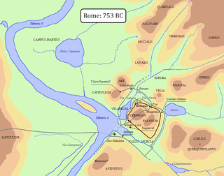
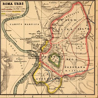
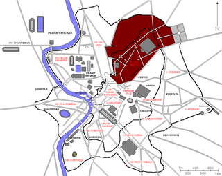
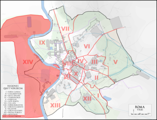
WIn 7 BC, Augustus divided the city of Rome into 14 administrative regions. These replaced the four regiones — or "quarters" — traditionally attributed to Servius Tullius, sixth king of Rome. They were further divided into official neighborhoods.
 W
WIn Ancient Rome, the Ager Vaticanus was the alluvial plain on the right (west) bank of the Tiber. It was also called Ripa Veientana or Ripa Etrusca, indicating the Etruscan dominion during the archaic period. It was located between the Janiculum, the Vatican Hill, and Monte Mario, down to the Aventine Hill and up to the confluence of the Cremera creek.
 W
WThe Almone is a small river of the Ager Romanus, a few miles south of the city of Rome. Today the river is polluted and is channelled to a sewage treatment plant and no longer reaches its natural confluence with the Tiber.
 W
WThe Argiletum was the main route approaching the Forum Romanum from the northeast in the ancient city of Rome. It connected the Forum with the Subura district of the city. Paths that were found in the Alta Semita and the domus on the Oppian and Caelian hills converged onto the Argiletum, making it a principal node of public space particularly during the Flavian rule.
 W
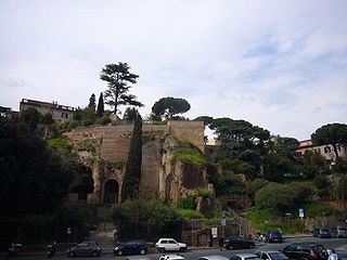
WArx is a Latin word meaning "citadel". In the ancient city of Rome, the arx was located on the northern spur of the Capitoline Hill, and is sometimes specified as the Arx Capitolina.
 W
WThomas Ashby, was a British archaeologist.
 W
WThe Campus Agrippae is the area within the boundaries of ancient Rome named after Marcus Vipsanius Agrippa. A number of construction projects were developed within its perimeters, including the Porticus Vipsania, built by his sister, Vipsania Polla, and finished by Augustus, which ran along the western perimeter, against the Via Lata. There was also a race course. In 7 BCE, Augustus declared the Campus open to the public.
 W
WThe Campus Martius was a publicly owned area of ancient Rome about 2 square kilometres in extent. In the Middle Ages, it was the most populous area of Rome. The IV rione of Rome, Campo Marzio, which covers a smaller section of the original area, bears the same name.
 W
WThe Ciconiae Nixae was a landmark, or more likely two separate landmarks, in the Campus Martius of ancient Rome. In A New Topographical Dictionary of Ancient Rome, Lawrence Richardson regards a single site called Ciconiae Nixae as "hypothetical," noting that the subject "has long exercised topographers." The two words are juxtaposed in the regionary lists and located in Region IX near the Tiber River. The 4th-century calendar of Filocalus notes vaguely that the October Horse happened ad nixas, "at the Nixae," suggesting that the regionaries' Ciconiae ("Storks") ought to be taken as a separate entry. Inscriptional evidence also indicates that the Ciconiae was a separate landmark, and that it had to do with wine shipments brought in on the Tiber.
 W
WThe Circus Flaminius was a large, circular area in ancient Rome, located in the southern end of the Campus Martius near the Tiber River. It contained a small race-track used for obscure games, and various other buildings and monuments. It was "built", or sectioned off, by Gaius Flaminius in 221 BC. After Augustus divided the city into 14 administrative regions, the Circus Flaminius gave its name to Region IX, which encompassed the Circus and all of the Campus Martius west of the Via Lata.
 W
WThe Columna Lactaria was a landmark in ancient Rome in the Forum Holitorium, or produce market. The Roman grammarian Festus says it was so called "because they would bring babies there to be fed with milk." It seems to have been a public charity where poor parents could obtain milk for their infants, or a central site for locating and hiring wet nurses. It has also been interpreted as a sanctioned site of child abandonment, where parents unable or unwilling to care for newborns could leave the child in the hope that it might be pitied and fostered.
 W
WThe Ficus Ruminalis was a wild fig tree that had religious and mythological significance in ancient Rome. It stood near the small cave known as the Lupercal at the foot of the Palatine Hill and was the spot where according to tradition the floating makeshift cradle of Romulus and Remus landed on the banks of the Tiber. There they were nurtured by the she-wolf and discovered by Faustulus. The tree was sacred to Rumina, one of the birth and childhood deities, who protected breastfeeding in humans and animals. St. Augustine mentions a Jupiter Ruminus.
 W
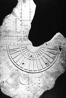
WThe Forma Urbis Romae or Severan Marble Plan is a massive marble map of ancient Rome, created under the emperor Septimius Severus between 203 and 211. Matteo Cadario gives specific years of 205–208, noting that the map was based on property records.
 W
WThe Forum of Corporations, or the Piazzale delle Corporazioni, was the principal center of commerce and trade for the Roman Empire mainly during the Age of Augustus. Located in the major port city of Ostia, this open-air market was essential for Rome as a place of varying and exotic goods from foreign lands. Merchants gathered here to sell anything from grain and shipping services to elephants and giraffes.
 W
WThe Lacus Curtius was a mysterious pit or pool in the ground in the Forum Romanum. The area where the Forum would later be built was originally likely a lake, as the area it was in is known to have been surrounded by brooks and marshes. One part of the area was never drained, but gradually became smaller until only a basin, known as the Lacus Curtius, was left. Its nature and significance in Rome's early history is uncertain, and several conflicting stories exist about its history.
 W
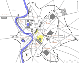
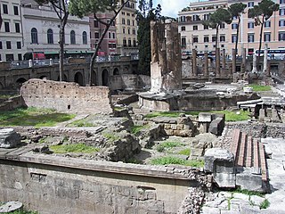
WLargo di Torre Argentina is a square in Rome, Italy, with four Roman Republican temples and the remains of Pompey's Theatre. It is in the ancient Campus Martius.
WThe Lupercal was a cave at the southwest foot of the Palatine Hill in Rome, located somewhere between the temple of Magna Mater and the Sant'Anastasia al Palatino. In the legend of the founding of Rome, Romulus and Remus were found there by the she-wolf who suckled them until they were rescued by the shepherd Faustulus. Luperci, the priests of Faunus, celebrated certain ceremonies of the Lupercalia at the cave, from the earliest days of the City until at least 494 AD.
 W
WAntonio Nibby was an Italian archaeologist and topographer.
WThe Palus Caprae was a site within the Campus Martius in Ancient Rome. In Roman mythology, the Palus Caprae was the place where Romulus underwent ascension into godhood.
 W
WThe pomerium or pomoerium was a religious boundary around the city of Rome and cities controlled by Rome. In legal terms, Rome existed only within its pomerium; everything beyond it was simply territory (ager) belonging to Rome.
 W
WIn ancient Roman religion and myth, the Querquetulanae or Querquetulanae virae were nymphs of the oak grove (querquetum) at a stage of producing green growth. Their sacred grove (lucus) was within the Porta Querquetulana, a gate in the Servian Wall. According to Festus, it was believed that in Rome there was once an oakwood within the Porta Querquetulana onto the greening of which presided the virae Querquetulanae.
 W
WThe Regio I Porta Capena is the first regio of imperial Rome, under Augustus's administrative reform. Regio I took its name from the Porta Capena, a gate of the Servian Walls, through which the Appian Way entered the city prior to the construction of the Aurelian Walls.
 W
WThe Regio II Caelimontium is the second regio of imperial Rome, under Augustus's administrative reform. It took its name from the Caelian Hill, which the region was centred on.
 W
WThe Regio III Isis et Serapis was the third regio of imperial Rome, under Augustus's administrative reform. Regio III took its name from the double sanctuary of Isis and Serapis, in the area of the Via Praenestina, containing the valley that was to be the future site of the Colosseum, and parts of the Oppian and Esquiline hills.
 W
WThe Regio IV Templum Pacis is the fourth regio of imperial Rome, under Augustus's administrative reform. Regio IV took its name from the Temple of Peace built in the region by the emperor Vespasian. It includes the valley between the Esquiline and the Viminal hills, the popular area of the Subura, and the Velian Hill.
 W
WThe Regio IX Circus Flaminius is the ninth regio of imperial Rome, under Augustus's administrative reform. Regio IX took its name from the racecourse located in the southern end of the Campus Martius, close to Tiber Island.
 W
WThe Regio V Esquiliae is the fifth regio of imperial Rome, under Augustus's administrative reform. Regio V took its name from the Esquiline Hill. It contains parts of the Oppian Hill and Cispian Hill and of the Esquiline, plus the plain just outside the Servian walls.
 W
WThe Regio VI Alta Semita is the sixth regio of imperial Rome, under Augustus's administrative reform. Regio VI took its name from the street passing over the Quirinal Hill. It was a large regio that also encompassed the Viminal Hill, the lower slopes of the Pincian, and the valleys in-between.
 W
WThe Regio VII Via Lata is the seventh regio of imperial Rome, under Augustus's administrative reform. Regio VII took its name from the wide urban street the Via Lata. It was the urban section of the Via Flaminia, which ran between the Servian walls and the Aurelian Walls, and corresponds to the modern Via del Corso. The regio contained part of the Campus Martius on the east of the street plus the Collis Hortulorum, the Pincian Hill.
 W
WThe Regio VIII Forum Romanum Magnum is the eighth regio of imperial Rome, under Augustus's administrative reform. Regio VIII took its name from the Roman Forum, the political epicentre of Ancient Rome.
 W
WThe Regio X Palatium is the tenth regio of imperial Rome, under Augustus's administrative reform. Regio X took its name from the Palatine Hill and the imperial palaces located on it.
 W
WThe Regio XI Circus Maximus is the eleventh regio of imperial Rome, under Augustus's administrative reform. Regio XI took its name from the Circus Maximus, located in the valley between the Palatine and the Aventine hills.
 W
WThe Regio XII Piscina Publica is the twelfth regio of imperial Rome, under Augustus's administrative reform. Regio XII took its name from the Piscina Publica, a swimming pool that disappeared during the middle imperial period.
 W
WThe Regio XIII Aventinus is the thirteenth regio of imperial Rome, under Augustus's administrative reform. Regio XIII took its name from the hill which dominated the region, the Aventine.
 W
WThe Regio XIV Transtiberim is the fourteenth regio of imperial Rome, under Augustus's administrative reform. Meaning "across the Tiber", the Regio took its name from its position on the east bank of the Tiber River.
WRoma quadrata was an area, or perhaps a structure, within the original pomerium of the ancient city of Rome, probably the Palatine Hill with its Palatium and Cermalus peaks and its slopes.
 W
WSuburra was an area of the city of Rome, Italy located below the Murus Terreus on the Carinae. In ancient Roman times, it was a crowded lower-class area that was also notorious as a pleasure district. It lies in the dip between the southern end of the Viminal and the western end of the Esquiline hills. Most of its inhabitants lived in insulae, tall apartment buildings with tabernae on the ground floor.
 W
WThe Tarpeian Rock is a steep cliff on the south side of the Capitoline Hill, which was used during the Roman Republic as a site of execution. Murderers, traitors, perjurors, and larcenous slaves, if convicted by the quaestores parricidii, were flung from the cliff to their deaths. The cliff was about 25 meters (80 ft) high.
 W
WThe Temple of Castor and Pollux is an ancient temple in the Roman Forum, Rome, central Italy. It was originally built in gratitude for victory at the Battle of Lake Regillus. Castor and Pollux were the Dioscuri, the "twins" of Gemini, the twin sons of Zeus (Jupiter) and Leda. Their cult came to Rome from Greece via Magna Graecia and the Greek culture of Southern Italy.
 W
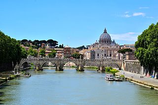
WThe Tiber is the second-longest river in Italy and the longest river in Central Italy, rising in the Apennine Mountains in Emilia-Romagna and flowing 406 kilometres (252 mi) through Tuscany, Umbria and Lazio, where it is joined by the river Aniene, to the Tyrrhenian Sea, between Ostia and Fiumicino. It drains a basin estimated at 17,375 square kilometres (6,709 sq mi). The river has achieved lasting fame as the main watercourse of the city of Rome, founded on its eastern banks.
 W
WThe Tiber Island is the only island in the part of the Tiber which runs through Rome. Tiber Island is located in the southern bend of the Tiber.
 W
WThe Trigarium was an equestrian training ground in the northwest corner of the Campus Martius in ancient Rome. Its name was taken from the triga, a three-horse chariot.
 W
WThe Velabrum is the low valley in the city of Rome that connects the Forum with the Forum Boarium, and the Capitoline Hill with the western slope of the Palatine Hill. It was believed that before the construction of the Cloaca Maxima, which probably follows the course of an ancient stream, the area was a swamp, though this claim has been disproven by core samples taken from Velabrum in 1994. Ancient authorities state that in this marshy area the roots of a fig tree (Ficus Ruminalis) caught and stopped the basket carrying Romulus and Remus as it floated along on the Tiber current. The place therefore has a high symbolic significance.
 W
WIn Ancient Rome, the vicus was a neighbourhood or settlement. During the Republican era, the four regiones of the city of Rome were subdivided into vici. In the 1st century BC, Augustus reorganized the city for administrative purposes into 14 regions, comprising 265 vici. Each vicus had its own board of officials who oversaw local matters. These administrative divisions are recorded as still in effect at least until the mid-4th century.
 W
WThe Shrine of Vulcan, or Vulcanal, or Volcanal, was an 8th-century BC sacred precinct on the future site of the Roman Forum in Rome, modern Italy. Dedicated to Vulcan, the Roman god of fire, it was traditionally considered to commemorate the spot where the legendary figures Romulus and Tatius concluded the peace treaty between the tribes known as the Latins — on the Palatine Hill — and the Sabines — on the Quirinal and Esquiline. This famous merger of the hill-villages was said to be the foundation of the Roman state.