 W
WThe Great Plains sometimes simply "the Plains" is a broad expanse of flat land, much of it covered in prairie, steppe, and grassland, located in the interior of North America. It lies west of the Mississippi River tallgrass prairie in the United States and east of the Rocky Mountains in the U.S. and Canada.
 W
WThe High Plains are a subregion of the Great Plains mostly in the Western United States, but also partly in the Midwest states of Nebraska, Kansas, and South Dakota, generally encompassing the western part of the Great Plains before the region reaches the Rocky Mountains. The High Plains are located in eastern Montana, southeastern Wyoming, southwestern South Dakota, western Nebraska, eastern Colorado, western Kansas, eastern New Mexico, western Oklahoma, and to just south of the Texas Panhandle. The southern region of the Western High Plains ecology region contains the geological formation known as Llano Estacado which can be seen from a short distance or on satellite maps. From east to west, the High Plains rise in elevation from around 1,800 feet (550 m) to over 7,000 feet (2,100 m).
 W
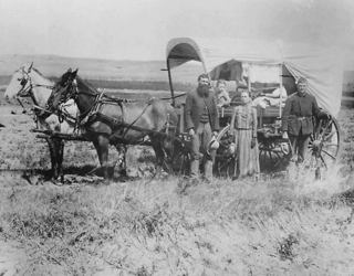
WPlains Indians or Indigenous peoples of the Great Plains and Canadian Prairies are the Native American tribes and First Nation band governments who have historically lived on the Interior Plains of North America. While hunting-farming cultures have lived on the Great Plains for centuries prior to European contact, the region is known for the horse cultures that flourished from the 17th century through the late 19th century. Their historic nomadism and armed resistance to domination by the government and military forces of Canada and the United States have made the Plains Indian culture groups an archetype in literature and art for Native Americans everywhere.
 W
WThe Great Plains toad, Anaxyrus cognatus, is a relatively large species of true toad native to central North America.
 W
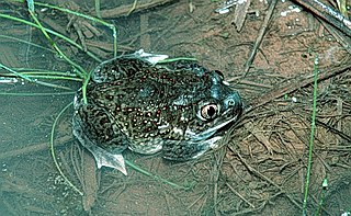
WThe plains spadefoot toad is a species of American spadefoot toad which ranges from southwestern Canada, throughout the Great Plains of the western United States, and into northern Mexico. Like other species of spadefoot toads, they get their name from a spade-like projections on their hind legs which allow them to dig into sandy soils. Their name, in part, comes from their keratinized metatarsals, which are wide instead of "sickle shaped". The species name translates as buzzing leaf shaped. This refers to the species distinguishing features; its buzzing mating call, and its leaf-shaped digging metatarsals. First described by Cope in 1863.
 W
WThe plains garter snake is a species of garter snake native to most of the central United States as far north as Canada and as far south as Texas. It has a distinctive orange or yellow stripe from its head to tail, and the rest of its body is mainly a gray-green color. The snake is commonly found living near water sources such as streams and ponds, but can also be found in urban areas and vacant lots. Although the IUCN lists the species as "Least Concern", some states have given it their own special status. This species is mildly venomous, although the venom is not toxic to humans.
 W
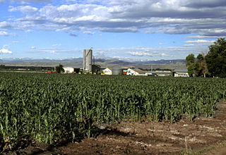
WAgriculture on the prehistoric Great Plains describes the agriculture of the Indian peoples of the Great Plains of the United States and southern Canada in the Pre-Columbian era and before extensive contact with European explorers, which in most areas occurred by 1750. The principal crops grown by Indian farmers were maize (corn), beans, and squash, including pumpkins. Sunflowers, goosefoot, tobacco, gourds, and plums, were also grown.
 W
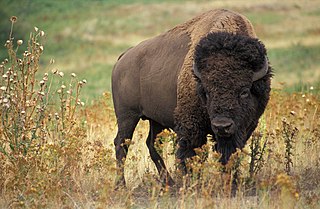
WThe American bison or simply bison, also commonly known as the American buffalo or simply buffalo, is an American species of bison that once roamed North America in vast herds. Its historical range, by 9000 BCE, is described as the great bison belt, a tract of rich grassland that ran from Alaska to the Gulf of Mexico, east to the Atlantic Seaboard as far north as New York and south to Georgia and, according to some sources, down to Florida, with sightings in North Carolina near Buffalo Ford on the Catawba River as late as 1750. It nearly became extinct by a combination of commercial hunting and slaughter in the 19th century and introduction of bovine diseases from domestic cattle. With a population in excess of 60 million in the late 18th century, the species was down to just 541 animals by 1889. Recovery efforts expanded in the mid-20th century, with a resurgence to roughly 31,000 wild bison today, largely restricted to a few national parks and reserves. Through multiple reintroductions, the species is now also freely roaming wild in some regions in Yakutia as well as Mexico.
 W
WThe American Bison Society (ABS) was founded in 1905 by pioneering conservationists and sportsmen including Ernest Harold Baynes, William T. Hornaday and Theodore Roosevelt to help save the bison from extinction and raise public awareness about the species.
 W
WThe Beaver Hills, also known as the Beaver Hills Moraine and the Cooking Lake Moraine, are a rolling upland region in Central Alberta, just to the east of Edmonton, the provincial capital. It consists of 1,572 square kilometres (607 sq mi) of "knob and kettle" terrain, containing many glacial moraines and depressions filled with small lakes. The major lakes were connected til Camrose reverse drained their headwaters, Miquelon. The landform lies partly within five different counties, Strathcona, Leduc, Beaver, Lamont and Camrose. The area is relatively undeveloped compared to the surrounding region, and is protected by in part by Elk Island National Park, the Cooking Lake–Blackfoot Provincial Recreation Area, the Ministik Bird Sanctuary, Miquelon Lake Provincial Park and a number of smaller provincial natural areas.
 W
WThe Black Hills are a small and isolated mountain range rising from the Great Plains of North America in western South Dakota and extending into Wyoming, United States. Black Elk Peak, which rises to 7,244 feet (2,208 m), is the range's highest summit. The Black Hills encompass the Black Hills National Forest. The name "Black Hills" is a translation of the Lakota Pahá Sápa. The hills are so called because of their dark appearance from a distance, as they are covered in evergreen trees.
WThe Buffalo Commons is a conceptual proposal to create a vast nature preserve by returning 139,000 square miles (360,000 km2) of the drier portion of the Great Plains to native prairie, and by reintroducing the American bison ("buffalo"), that once grazed the shortgrass prairie. The proposal would affect ten states: Montana, Wyoming, Colorado, Oklahoma, New Mexico, Texas, North Dakota, South Dakota, Nebraska, and Kansas.
 W
WThe Canadian Prairies is a region in Western Canada. It includes the Canadian portion of the Great Plains and the Prairie Provinces, namely Alberta, Saskatchewan, and Manitoba. These provinces are partially covered by grasslands, plains, and lowlands, mostly in the southern regions. The northernmost reaches of the Canadian Prairies are less well known. They are marked by forests and more variable topography. If the region is defined to include areas only covered by prairie land, the corresponding region is known as the Interior Plains. Geographically, the Canadian prairies extend to northeastern British Columbia, but this province is not included in a political manner.
 W
WCentral Texas is a region in the U.S. state of Texas surrounding Austin and roughly bordered by San Saba to Bryan and San Marcos to Hillsboro. Central Texas overlaps with and includes part of the Texas Hill Country and corresponds to a physiographic section designation within the Edwards Plateau, in a geographic context.
 W
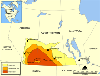
WChernozem is a black-colored soil containing a high percentage of humus and high percentages of phosphoric acids, phosphorus, and ammonia. Chernozem is very fertile and can produce high agricultural yields with its high moisture storage capacity. Chernozems are also a Reference Soil Group of the World Reference Base for Soil Resources (WRB).
 W
WCheyenne Bottoms is a wetland in the central Great Plains of North America. Occupying approximately 41,000 acres in central Kansas, it is the largest wetland in the interior United States. The Bottoms is a critical stopping point on the Central Flyway for millions of birds which migrate through the region annually.
 W
WThe Comancheria or Comanchería is the region of New Mexico, west Texas and nearby areas occupied by the Comanche before the 1860s.
 W
WThe Coteau des Prairies is a plateau approximately 200 miles in length and 100 miles in width, rising from the prairie flatlands in eastern South Dakota, southwestern Minnesota, and northwestern Iowa in the United States. The southeast portion of the Coteau comprises one of the distinct regions of Minnesota, known as Buffalo Ridge.
 W
WThe Coteau du Missouri, or Missouri Plateau, is a large plateau that stretches along the eastern side of the valley of the Missouri River in central North Dakota and north-central South Dakota in the United States. In the Canadian provinces of Saskatchewan and Alberta this physiographic region is classified as the uplands Missouri Coteau, which is a part of the Great Plains Province or Alberta Plateau Region, which extends across the southwest corner of the province of Saskatchewan as well as the southeast corner of the province of Alberta. Historically, in Canada the area was known as the Palliser's Triangle regarded as an extension of the Great American Desert and unsuitable for agriculture and thus designated by Canadian geographer and explorer John Palliser. The terrain of the Missouri Coteau features low hummocky, undulating, rolling hills, potholes, and grasslands. Apart from being a geographical area, the Coteau du Missouri also has a cultural connection to the people of the area, the Metis people of South Dakota along with other Indigenous groups. The history of this plateau is large, and the Coteau du Missouri has a significance to these people.
 W
WCrow Scouts worked with the United States Army in several conflicts, the first in 1876 during the Great Sioux War. Because the Crow Nation was at that time at peace with the United States, the army was able to enlist Crow warriors to help them in their encroachment against the Native Americans with whom they were at war. In 1873, the Crow called for U.S. military actions against the Indigenous people they reported were trespassing into the newly-designated Crow reservation territories.
 W
WThe depopulation of the Great Plains refers to the large-scale migration of people from rural areas of the Great Plains of the United States to more urban areas and to the east and west coasts during the 20th century. This phenomenon of rural-to-urban migration has occurred to some degree in most areas of the United States, but has been especially pronounced in the Great Plains states, including Texas, Oklahoma, Kansas, Nebraska, South Dakota, North Dakota, Montana, Wyoming, Colorado, and New Mexico, where many counties have lost more than 60 percent of their former populations.
 W
WThe Dust Bowl was a period of severe dust storms that greatly damaged the ecology and agriculture of the American and Canadian prairies during the 1930s; severe drought and a failure to apply dryland farming methods to prevent the aeolian processes caused the phenomenon. The drought came in three waves, 1934, 1936, and 1939–1940, but some regions of the High Plains experienced drought conditions for as many as eight years.
 W
WNative Americans from various tribes lived in North Dakota before the arrival of settlers. With time, a number of treaties and agreements were signed between the Indians and the newcomers. Many of the treaties defined the domain of a specific group of Indians. The three maps below show the treaty territories of different Indians living in North Dakota and how the territories changed and diminished over time in the 19th century.
 W
WEastern Montana is a loosely defined region of Montana. Some definitions are more or less inclusive than others, ranging from the most inclusive, which would include the entire part of the state east of the Continental Divide, to the least inclusive, which places the beginning of "eastern" Montana roughly at or even east of Billings, Montana. The areas of Montana lying just east of the Continental Divide are often called Central Montana. A widely accepted definition of Eastern Montana is that it encompasses the eastern third of the state.
 W
WThe Eastern Plains of Colorado refers to a region of the U.S. state of Colorado east of the Rocky Mountains and east of the population centers of the Front Range.
 W
WThe Fox Hills Formation is a Cretaceous geologic formation in the northwestern Great Plains of North America. It is present from Alberta on the north to Colorado in the south.
 W
WThe Grapes of Wrath is an American realist novel written by John Steinbeck and published in 1939. The book won the National Book Award and Pulitzer Prize for fiction, and it was cited prominently when Steinbeck was awarded the Nobel Prize in 1962.
 W
WThe term Great American Desert was used in the 19th century to describe the western part of the Great Plains east of the Rocky Mountains in North America to about the 100th meridian. It can be traced to the 1820 Stephen H. Long's scientific expedition which put the Great American Desert on the map.
 W
WThe great bison belt is a tract of rich grassland that ran from Alaska to the Gulf of Mexico around 9000 BC. The great bison belt was supported by spring and early summer rainfall that allowed short grasses to grow. These grasses retain their moisture at the roots which allowed for grazing ungulates such as bison to find high-quality nutritious food in autumn.
 W
WThe Great Plains Shelterbelt was a project to create windbreaks in the Great Plains states of the United States, that began in 1934. President Franklin D. Roosevelt initiated the project in response to the severe dust storms of the Dust Bowl, which resulted in significant soil erosion and drought. The United States Forest Service believed that planting trees on the perimeters of farms would reduce wind velocity and lessen evaporation of moisture from the soil. By 1942, 220 million trees had been planted, stretching out 18,600 miles (29,900 km) in a 100-mile-wide zone from Canada to the Brazos River. Even as of 2007, "the federal response to the Dust Bowl, including the Prairie States Forestry Project which planted the Great Plains Shelterbelt and creation of the Soil Erosion Service, represents the largest and most-focused effort of the [U.S.] government to address an environmental problem".
 W
WThe history of the U.S. state of Nebraska dates back to its formation as a territory by the Kansas–Nebraska Act, passed by the United States Congress on May 30, 1854. The Nebraska Territory was settled extensively under the Homestead Act of 1862 during the 1860s, and in 1867 was admitted to the Union as the 37th U.S. state. The Plains Indians were descendants of succeeding cultures of indigenous peoples who have occupied the area for thousands of years.
 W
WThe Llano Estacado, commonly known as the Staked Plains, is a region in the Southwestern United States that encompasses parts of eastern New Mexico and northwestern Texas. One of the largest mesas or tablelands on the North American continent, the elevation rises from 3,000 feet (900 m) in the southeast to over 5,000 feet (1,500 m) in the northwest, sloping almost uniformly at about 10 feet per mile (1.9 m/km).
 W
WThe Louisiana Purchase was the acquisition of the territory of Louisiana by the United States from France in 1803. In return for fifteen million dollars, or approximately eighteen dollars per square mile, the United States nominally acquired a total of 828,000 sq mi. However, France only controlled a small fraction of this area, most of it inhabited by American Indians; for the majority of the area, what the United States bought was the "preemptive" right to obtain Indian lands by treaty or by conquest, to the exclusion of other colonial powers. The total cost of all subsequent treaties and financial settlements over the land has been estimated to be around 2.6 billion dollars.
 W
WThe Territory of Louisiana or Louisiana Territory was an organized incorporated territory of the United States that existed from July 4, 1805, until June 4, 1812, when it was renamed the Missouri Territory. The territory was formed out of the District of Louisiana, which consisted of the portion of the Louisiana Purchase north of the 33rd parallel.
 W
WMcPherson Valley Wetlands are a disconnected chain of marshes, wetlands, and shallow lakes in McPherson County, Kansas. Once covering a much larger area, 4,455 acres of the wetlands and surrounding prairie had been preserved by the Kansas Department of Wildlife, Parks, and Tourism as of 2011.
 W
WThe Territory of Missouri was an organized incorporated territory of the United States that existed from June 4, 1812 until August 10, 1821. In 1819, the Territory of Arkansas was created from a portion of its southern area. In 1821, a southeastern portion of the territory was admitted to the Union as the State of Missouri, and the rest became unorganized territory for several years.
 W
WThe Ogallala Aquifer is a shallow water table aquifer surrounded by sand, silt, clay, and gravel located beneath the Great Plains in the United States. One of the world's largest aquifers, it underlies an area of approximately 174,000 sq mi (450,000 km2) in portions of eight states. It was named in 1898 by geologist N. H. Darton from its type locality near the town of Ogallala, Nebraska. The aquifer is part of the High Plains Aquifer System, and rests on the Ogallala Formation, which is the principal geologic unit underlying 80% of the High Plains.
 W
WPawnee Scouts were employed by the United States Army in the latter half of the 19th century. Like other groups of Indian scouts, Pawnee men were recruited in large numbers to aid in the ongoing conflicts between colonists and the Native Americans in the United States. Because the Pawnee people were at times involved in territorial skirmishes with the Sioux and Cheyenne, some of them were amenable to serving with the army for pay. A number of Pawnee served between 1865 and 1871. They were armed with rifles, revolvers and were issued scout uniforms.
 W
WThe Pierre Shale is a geologic formation or series in the Upper Cretaceous which occurs east of the Rocky Mountains in the Great Plains, from Pembina Valley in Canada to New Mexico.
 W
WPort Silt Loam is the state soil of Oklahoma. This type of soil is reddish in color due to the weathering of reddish sandstones, siltstones, and shales of the Permian period.
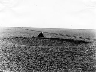
WPrairie madness or prairie fever was an affliction that affected settlers in the Great Plains during the migration to, and settlement of, the Canadian Prairies and the Western United States in the nineteenth century. Settlers moving from urbanized or relatively settled areas in the East faced the risk of mental breakdown caused by the harsh living conditions and the extreme levels of isolation on the prairie. Symptoms of prairie madness included depression, withdrawal, changes in character and habit, and violence. Prairie madness sometimes resulted in the afflicted person moving back East or, in extreme cases, suicide.
 W
WPre-Columbian savannas of North America, consisting of a mixed woodland-grassland ecosystem, were maintained by both natural lightning fires and by Native Americans before the significant arrival of Europeans. Although decimated by widespread epidemic disease, Native Americans in the 16th century continued using fire to clear savanna until European colonists began colonizing the eastern seaboard. Many colonists continued the practice of burning to clear underbrush, reinforced by their similar experience in Europe, but some land reverted to forest.
 W
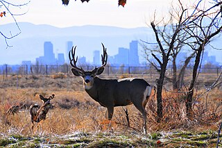
WThe Rocky Mountain Arsenal National Wildlife Refuge is a 15,988-acre (64.70 km2) National Wildlife Refuge located adjacent to Commerce City, Colorado, in the United States. It is approximately 8 miles (13 km) northeast of downtown Denver. The refuge is on the grounds of the former Rocky Mountain Arsenal, a United States Army chemical weapons manufacturing facility. The site was designated a national wildlife refuge in 1992 by the United States Congress, and underwent a costly environmental cleanup in order to remove pollutants. The refuge is managed by the United States Fish and Wildlife Service. More than 330 species of wildlife inhabit the refuge, including raptors, deer, raccoons, coyotes, white pelicans, black-footed ferrets, black-tailed prairie dogs, and bison.
 W
WThe Rocky Mountain Front is a somewhat unified geologic and ecosystem area in North America where the eastern slopes of the Rocky Mountains meet the plains. In 1983, the Bureau of Land Management called the Rocky Mountain Front "a nationally significant area because of its high wildlife, recreation, and scenic values". Conservationists Gregory Neudecker, Alison Duvall, and James Stutzman have described the Rocky Mountain Front as an area that warrants "the highest of conservation priorities" because it is largely unaltered by development and contains "unparalleled" numbers of wildlife.
 W
WThe South Plains is a region in northwest Texas, consisting of 24 counties. The main crop is cotton.
 W
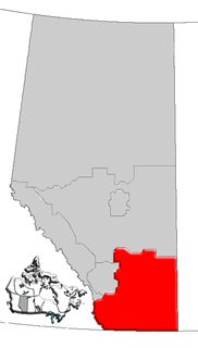
WSouthern Alberta is a region located in the Canadian province of Alberta. In 2004, the region's population was approximately 272,017. The primary cities are Lethbridge and Medicine Hat. The region is known mostly for agricultural production, but other sectors, such as alternative energy, film production and tourism, are emerging.
 W
WThe White River Formation is a geologic formation of the Paleogene Period, in the northern Great Plains and central Rocky Mountains, within the United States.