 W
WThe Murray River is a river in southeastern Australia. It is Australia's longest river at 2,508 km (1,558 mi) in length, and its tributaries include five of the next six longest rivers of Australia, whose catchment area together form the Murray-Darling basin.
 W
WBanrock Station Wetland Complex is a wetland complex located in South Australia which has been recognised as being of international importance by designation under the Ramsar Convention. It was listed on 21 October 2002 as Ramsar site 1221. It lies in the Riverland region of south-eastern South Australia and is adjacent to the Murray River. It is a floodplain wetland subject to an ongoing environmental restoration program by a commercial organisation which manages the wetlands and promotes ecologically sustainable land use practices. In 2002 Banrock Station Wines received the Ramsar Wetland Conservation Award in recognition of its conservation efforts.
 W
WThe Barmah National Park, formerly Barmah State Park, is a national park located in the Hume region of the Australian state of Victoria. The park is located adjacent to the Murray River near the town of Barmah, approximately 225 kilometres (140 mi) north of Melbourne. The park consists of river red gum floodplain forest, interspersed with treeless freshwater marshes. The area is subject to seasonal flooding from natural and irrigation water flows.
 W
WThe Cadell Fault is a north-south trending intra-plate geological fault in the Riverina area of New South Wales and Victoria within Australia. It straddles the Murray River and in quite recent prehistoric times has impacted its course, as well as the courses of the Edward River, Wakool River, Goulburn River and Campaspe River. The Cadell Fault is notable due to this impact and has been described as one of the most significant examples of seismic activity changing the course of rivers. The fault is visible as a continuous earthen ridge along the Cobb Highway between Deniliquin and Echuca, and extending further south into Victoria. The fault is likely named after Francis Cadell, an early pioneer of the Murray River and river trader.
 W
WChowilla Game Reserve is a protected area covering the floodplain on the north side of the River Murray in South Australia from about 8 kilometres north-east of Renmark to the New South Wales border. It was proclaimed 8 April 1993 in conjunction with the Chowilla Regional Reserve. Its creation arises from a community consultation process which recommended that ‘hunting of waterfowl be a permitted activity in selected areas of the Chowilla floodplain’. The game reserve is classified as an IUCN Category VI protected area.
 W
WThe Coorong National Park is a protected area located in South Australia about 156 kilometres (97 mi) southeast of Adelaide and that predominantly covers a lagoon ecosystem officially known as the Coorong and the Younghusband Peninsula on the Coorong's southern side.
 W
WThe Cootamundra Domestic Training Home for Aboriginal Girls, commonly known as "Bimbadeen" and Cootamundra Girls' Home, located at Cootamundra, New South Wales operated by the New South Wales Aborigines Welfare Board from 1911 to 1968 to provide training to girls forcibly taken from their families under the Aborigines Protection Act 1909. These girls were members of the Stolen generations and were not allowed any contact with their families, being trained to work as domestic servants.
 W
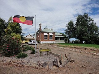
WCummeragunja Reserve or Cummeragunja Station, alternatively spelt Coomeroogunja, Coomeragunja, Cumeroogunga and Cummerguja, was a settlement on the New South Wales side of the Murray River, on the Victorian border near Barmah. It was also referred to as Cumeroogunga Mission, although it was not run by missionaries. The people were mostly Yorta Yorta.
WCurrency Creek Game Reserve is a protected area in the Australian state of South Australia located on the south-western side of Lake Alexandrina in the gazetted localities of Currency Creek and Goolwa North about 0.5 kilometres north-east of Goolwa.
 W
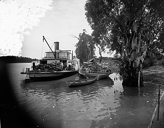
WEchuca Wharf is a historic timber wharf on the Murray River at Echuca in Victoria, Australia. The simultaneous construction of the wharf and the railway line between Echuca and Melbourne in 1864 saw the Port of Echuca become the second largest port in Victoria and opened access to Melbourne ports and markets for much of the Murray-Darling basin.
 W
WEmydura macquarii, is a wide-ranging species that occurs throughout many of the rivers of the eastern half of Australia. It is found primarily in the Macquarie River basin and all its major tributaries, along with a number of coastal rivers up the New South Wales Coast. It is also found in the coastal Queensland rivers and the Cooper Creek ecosystem, along with Fraser Island.
 W
WThe Great Darling Anabranch, commonly called the Darling Anabranch, is an anabranch and ancestral path of the Darling River in the lower Murray-Darling basin in the Far West and Riverina regions of New South Wales, Australia.
 W
WThe Hindmarsh Island bridge controversy was a 1990s Australian legal and political controversy that involved the clash of local Aboriginal Australian sacred culture and property rights. A proposed bridge to Hindmarsh Island, near Goolwa, South Australia attracted opposition from many local residents, environmental groups and indigenous leaders. In 1994, a group of Ngarrindjeri women elders claimed the site was sacred to them for reasons that could not be revealed. The case attracted much controversy because the issue intersected with broader concerns about Indigenous rights, specifically Aboriginal land rights, in the Australian community at the time, and coincided with the Mabo and Wik High Court cases regarding Native title in Australia.
WKapunda Island Conservation Park is a protected area in the Australian state of South Australia located on the Riverland in the gazetted locality of Loxton about 1 kilometre (0.62 mi) north-west of the Loxton town centre.
W.
 W
WLake Albert, also known by its Ngarrindjeri name, Yarli, is a notionally fresh water lake near the mouth of the Murray River in South Australia. It is filled by water flowing in from the larger Lake Alexandrina at its mouth near Narrung. It is separated on the south by the Narrung Peninsula from the salt-water Coorong. The only major town on the lake is Meningie. Lakes Alexandrina and Albert are together known as the Lower Lakes.
 W
WLake Alexandrina is a coastal freshwater lake located between the Fleurieu and Kangaroo Island and Murray and Mallee regions of South Australia, about 100 kilometres (62 mi) south-east of Adelaide. The lake adjoins the smaller Lake Albert and a coastal lagoon called The Coorong to its southeast, before draining into the Great Australian Bight via a short, narrow opening known as Murray Mouth.
 W
WLake Victoria, a naturally occurring shallow freshwater lake of the Murray catchment and part of the Murray-Darling basin, is located in the western Riverina region of south western New South Wales, Australia.
 W
WThe Little Murray River, an anabranch of the Murray River and part of the Murray-Darling basin, is located in the Mallee district of north western Victoria, in eastern Australia.
WLoch Luna Reserve is a protected area covering the floodplain on the north side of the River Murray in South Australia between the towns of Kingston-on-Murray in the west and Cobdogla in the east. It is located about 180 kilometres east north-east of the Adelaide city centre. It was proclaimed on 7 November 1985 with exception to a parcel of land known as Sugarloaf Hill within the boundaries of the game reserve which has been excluded from protection for the purpose of mining activity. The Moorook Game Reserve immediately adjoins the game reserve's southern boundary. It and the Moorook Game Reserve are reported as providing "significant wildlife habitat and are popular recreation sites, particularly for river-based activities and camping." The game reserve is classified as an IUCN Category VI protected area. In 1989, it was listed on the now-defunct Register of the National Estate.
 W
WLong Island Recreation Park is a protected area in the Australian state of South Australia occupying the full extent of Long Island in the Murray River immediately east of the city of Murray Bridge.
WLoveday Bay is an inlet in the Australian state of South Australia located at the south-eastern end of Lake Alexandrina on the west coast of the Narrung Peninsula.
WMedia Island Conservation Park is a protected area in the Australian state of South Australia located in the Riverland in the gazetted locality of Loxton about 3 kilometres (1.9 mi) north-east of the Loxton town centre.
WMoorook Game Reserve is a protected area in the Australian state of South Australia covering the floodplain on the south side of the River Murray in the localities of Kingston-on-Murray and Moorook immediately south of the section of the Sturt Highway that passes between the towns of Kingston-on-Murray in the west and Cobdogla in the east. It is located about 180 kilometres east north-east of the state capital of Adelaide.
WMud Islands Game Reserve is a protected area in South Australia covering ten islands at the southern side of Lake Alexandrina about 19 kilometres south-east of Goolwa. The game reserve is described as providing ‘an ideal habitat for water birds, particularly waterfowl’ and that ‘duck shooting is permitted during open season.’ Since 2000, the game reserve has been located within the boundaries of the gazetted locality, Coorong.
 W
WLake Mulwala, a man–made reservoir created through the construction of the Yarrawonga Weir across the Murray River, is located between Bundalong and Yarrawonga in Hume region of Victoria and Mulwala in the Riverina region of New South Wales, in eastern Australia. The weir was constructed in 1939 to provide water for irrigation of the surrounding district. The weir also serves as a crossing of the Murray between the two towns; in addition to the crossing located via the Mulwala Bridge.
 W
WThe Mulwala Canal is an irrigation canal in the southern Riverina region of New South Wales, Australia. It is the largest irrigation canal in the Southern Hemisphere. The canal, starting at Lake Mulwala, diverts water from the Murray River across the southern Riverina plain to the Edward River at Deniliquin. The canal is 2880 km long. The channel has an offtake capacity of 10,000 megalitres (ML) per day and annually supplies over 1,000,000 ML to 700,000 hectares in the Murray Irrigation Area.
WMundoo Island is a locality in the Australian state of South Australia located on Mundoo Island and some adjoining water at the southern end of Lake Alexandrina about 87 kilometres (54 mi) south-east of the state capital of Adelaide.
 W
WThe Murray Basin is a Cenozoic sedimentary basin in south eastern Australia. The basin is only shallow, but extends into New South Wales, Victoria and South Australia. It takes its name from the Murray River which traverses the Basin from east to west.
 W
WMurray Mouth is the point at which the River Murray meets the Southern Ocean. The Murray Mouth's location is changeable. Historical records show that the channel out to sea moves along the sand dunes over time. At times of greater river flow and rough seas, the two bodies of water would erode the sand dunes to create a new channel leaving the old one to silt and disappear.
 W
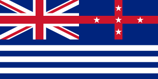
WThe Murray River Flag is flown from paddle steamers and other vessels in the Australian States of New South Wales, Victoria and South Australia that ply the waters of the Murray-Darling river system. Little is known about the flag's early history but it may have originated as far back as 1850 when the formation of the Murray River League was announced. R. W. Beddome, founder of the League, enthused "Up with the Murray flag." No fragments of the original Murray River Flag are known to exist and three variants have passed down to the present day.
WMurray River National Park is a protected area in South Australia located between 180 kilometres (110 mi) and 240 km (150 mi) north east of the Adelaide city centre. The national park was proclaimed in 1991 "to conserve a significant proportion of South Australia’s floodplain environments which are not represented widely in other reserve systems." The national park consists of three sections adjoining the Murray River and extending from near Loxton in the south west to near Renmark in the north-east. The first which is known as the ‘Katarapko’ section is located on the north side of the river between Loxton in the south and Berri in the north. The second section which is known as the ‘Lyrup Flats’ section is located on the north side of the river midway between Berri and Loxton. The third section is known as the ‘Bulyong’ section is located on the west side of the river upstream from Renmark. The national park is classified as an IUCN Category VI protected area.
WNurrang Peninsula is a peninsula in the Australian state of South Australia located at the south east end of Lake Alexandrina. It is bounded by Lake Alexandrina to the west, by Lake Albert to the north and to the east, and by the Coorong to the south. While the name appears to have been in use since the 19th century and by all levels of government in South Australia, the name was not listed in the state government's official list of placenames until January 2020. Its extent is within the localities of Meningie West and Narrung.
 W
WPental Island is an island and rural locality in Victoria, Australia, bordering Swan Hill, Victoria in the north. The island is bounded by the Murray River in the north and the Little Murray River in the south; the Little Murray diverging from the Murray at Fish Point and converging at Swan Hill. Pental Island is also a parish of the County of Tatchera and the boundaries of the three entities are identical. At the 2006 census, Pental Island had a population of 380. The indigenous Wemba Wemba name for the island is Pakaruk.
 W
WThe Pioneer Settlement, in Swan Hill, Victoria, is Australia's first open-air museum, portraying life on the Murray in the era 1830-1930. It opened in 1966 as the Swan Hill Folk Museum, before being renamed, following a visit by the Queen in 1970. It contains approximately 50 replica buildings, including Masonic hall, coach-house, post office, photographic studio, original 1895 kaiserpanorama, and newspaper office. The collection also contains numerous tractors – including the first tractor ever brought to Australia – and historic vehicles, and two 19th century riverboats, including the 1876 paddlesteamer PS Gem. This vessel was towed to the site in 1963, and now functions as the main entrance and contains a restaurant.
The Rambler Football Club, nicknamed the Roosters, is an Australian rules football club that plays in the River Murray Football League and is one of two teams based in Murray Bridge, South Australia, the other being the Imperial Football Club.
WRilli Island Conservation Park is a protected area in the Australian state of South Australia located on the Riverland in the gazetted locality of Loxton North about 6.5 kilometres (4.0 mi) north-east of the Loxton town centre.
 W
WThe Riverland is a region of South Australia. It covers an area of 9,386 square kilometres (3,624 sq mi) along the Murray River from where it flows into South Australia from New South Wales and Victoria downstream to Blanchetown. The major town centres are Renmark, Berri, Loxton, Waikerie, Barmera and Monash, along with many minor townships; the population is approximately 35,000 people.
 W
WThe Riverland Biosphere Reserve, formerly the Bookmark Biosphere Reserve, is a 9,000 square kilometres area of land in eastern South Australia, adjoining the states of New South Wales and Victoria. It is one of 14 biosphere reserves in Australia and is part of the World Network of Biosphere Reserves, being officially recognized and listed by UNESCO in 1977.
WSalt Lagoon Islands Conservation Park is a protected area covering two islands and some adjoining waters in Salt Lagoon at the south east extent of Lake Alexandrina in South Australia about 14 kilometres south-west of Narrung.
 W
WThe Snowy Mountains scheme or Snowy scheme is a hydroelectricity and irrigation complex in south-east Australia. The Scheme consists of sixteen major dams; nine power stations; two pumping stations; and 225 kilometres (140 mi) of tunnels, pipelines and aqueducts that were constructed between 1949 and 1974. The Scheme was completed under the supervision of Chief Engineer, Sir William Hudson. It is the largest engineering project undertaken in Australia.
The Southern 80 is an annual water-ski race held on the Murray River in Australia, finishing at the Victorian/NSW border towns of Echuca and Moama. The race, held on the second weekend in February, currently attracts around 900 competitors and 260 boats, as well as tens of thousands of spectators. Teams of four make up the vast bulk of entries over the 39 different classes, with racing on Saturday held over a 20 km course, starting at the Five Mile boat ramp and finishing at Victoria Park in Echuca, while Sunday's racing is held over the full 80 km course, starting from Torrumbarry Weir and finishing at Victoria Park. Classes cater for different engine capacities of both inboards and outboards, as well as a range of age classes. There is also a women's and disabled class, and series of Social classes for skiers who use waterskis with the same dimensions and bindings as regular slalom skis, rather than the long "rail" waterskis used by Expert class skiers
 W
WSpeewa is a rural locality in the Riverina District of New South Wales, Australia near the Murray River in Murray River Council local government area.
WTolderol Game Reserve is a protected area in the Australian state of South Australia located on the north-western side of Lake Alexandrina in the localities of Lake Alexandrina and Tolderol about 11 kilometres south-east of Langhorne Creek.
 W
WWalker Flat is a small town on the Murray River in South Australia. It is one of the crossings of the river by cable ferry. The school opened in 1948 but has since closed. Walker Flat is located approximately 104 kilometres (65 mi) from the Adelaide city centre.
 W
WWellington Weir was a weir proposed for the River Murray several kilometres south of the town of Wellington, South Australia, immediately upstream from where the river enters Lake Alexandrina.
 W
WThe Yorta Yorta, also known as Jotijota, are an Aboriginal Australian people who have traditionally inhabited the area surrounding the junction of the Goulburn and Murray Rivers in present-day north-eastern Victoria and southern New South Wales.