 W
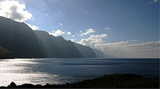
WAcantilados de Los Gigantes are vertical cliffs along the western coast of Tenerife. They are vertical walls reaching heights of 500 metres in some places. They are a basaltic geological feature. In times of the Guanches they were known as the 'Wall of Hell ".
 W
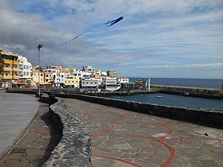
WAjuy is a small remote fishing village on the west coast of Fuerteventura in the Canary Islands. It is part of the municipality Pájara. Not far from Ajuy is where the Norman Jean de Béthencourt landed in 1402 in order to conquer the island for the Spanish crown.
 W
WArrieta is a small coastal village on the municipality of Haría, which is the northernmost municipality of island of Lanzarote. In 2013 about 300 people lived in Arrieta. The beach is famous and very popular among locals and tourists. As a tourist destination it is pretty crowded in the seasons and there are amenities for ~2000 guests in the direct vicinity of Arrieta.
 W
WThe Barranco de Badajoz or Chamoco is a ravine on the island of Tenerife, in the province of Santa Cruz de Tenerife, part of the municipality of Güímar in the southeast of the island.
 W
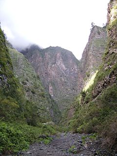
WThe Barranco del Infierno is a ravine located in the town of Adeje in the south of the island of Tenerife, Canary Islands, Spain.
 W
WCaleta de Fuste is the largest community in the municipality of Antigua, Las Palmas, Spain, on the island of Fuerteventura in the Canary Islands.
 W
WThe Chinijo Archipelago is a small archipelago located in the northeastern part of the Canary Islands, north of the island of Lanzarote. The archipelago includes the islets of Montaña Clara, Alegranza, La Graciosa, Roque del Este and Roque del Oeste. The archipelago is administered by Lanzarote and belongs to the municipality of Teguise. La Graciosa is the only inhabited island, with a population of around 700.
 W
WCofete is a small village in the western part of the Jandía peninsula in Fuerteventura, Canary Islands. It is part of the municipality Pájara. It is situated in a nature reserve. The Villa Winter is situated on a mountain slope near Cofete.
 W
WCosta Teguise is a coastal town in the Municipality of Teguise on the island of Lanzarote. It was built intentionally to accommodate tourism, and prior to building commencing the streets were planned, constructed, and serviced in advance.
 W
WEl Cuchillo is a village in Tinajo, Las Palmas province of western Lanzarote in the Canary Islands
 W
WCueva de los Verdes is a lava tube and tourist attraction of the Haria municipality on the island of Lanzarote in the Canary Islands (Spain). The cave lies within the Monumento Natural del Malpaís de La Corona, a protected area of the Canary Islands.
 W
WEl Dedo de Dios is a 30 m (98 ft) high sea stack in the Atlantic Ocean, off the northern part of Gran Canaria, one of the Canary Islands. During Tropical Storm Delta in November 2005, the thin top of this geological formation broke off and fell into the sea.
 W
WGolf del Sur is a holiday resort and golf course situated in Tenerife, Canary Islands within the municipality of San Miguel de Abona.
 W
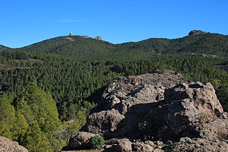
WMount Guajara is a 2,718 m (8,917 ft) high mountain on Tenerife, in the Canary Islands.
 W
WIdafe Rock is a natural stone pillar located in Caldera de Taburiente National Park on the island of La Palma in the Canary Islands.
 W
WLa Oliva is a town and a municipality in the northern part of the island of Fuerteventura in the Province of Las Palmas, Canary Islands, Spain. The population is 25,083 (2013), and the area is 356.13 km². The municipality includes the Lobos Island to the northeast. The largest town of the municipality, Corralejo, is a port town and beach resort at the northernmost point of the island. La Oliva is the historic seat of the island Colonel, who resided in the stately Casa de los Coroneles.
 W
WLa Tejita is a beach in the municipality of Granadilla de Abona, in Tenerife, Spain. It is listed as a protected area by the Spanish ministry for the environment. It is popular with windsurfers and hosted the 2015 world championship.
 W
WLos Abrigos is a small fishing village in Granadilla de Abona, Tenerife. It has a small harbour, which developers want to expand.
 W
WMala is a village in the municipality of Haría on Lanzarote in the province of Las Palmas in the Canary Islands. Its population in 2012 was 533.
 W
WMancha Blanca is a village in Tinajo, Las Palmas province of western Lanzarote in the Canary Islands. In Mancha Blanca is the chapel of the Our Lady of Dolours, the patron saint of the island of Lanzarote.
 W
WMeloneras is a tourist town on the south coast of the island of Gran Canaria, Canary Islands, part of the town of Meloneras in the municipality of San Bartolomé de Tirajana.
 W
WMontaña Clara is a small uninhabited islet belonging to the Chinijo Archipelago, in the northeastern part of the Canary Islands, only a short distance northwest of La Graciosa. The islet area is only 1.33 km². The highest point of the island is 256 m (840 ft) above sea level.
 W
WVolcán de La Corona is a 609 meters (1,998 ft) high extinct volcano on the Canary Island of Lanzarote (Spain), near the village of Yé in the municipality of Haría. Its eruption around 4000 years ago covered a large area of the northeast of the island with nev juice, creating the Malpais de la Corona and two of the island's most-visited geological attractions, the Cueva de los Verdes and the Jameos del Agua.
 W
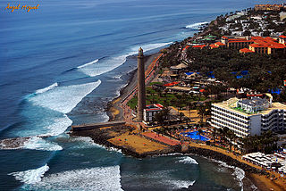
WThe Morro Jable Lighthouse is an active lighthouse on the Canary island of Fuerteventura. The lighthouse is situated at the edge of the beach near the town and resort of Morro Jable.
 W
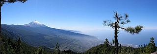
WThe Orotava Valley is an area in the northern part of the island of Tenerife, Canary Islands, Spain. The valley measures 10 km by 11 km, and stretches from the north coast to about 2,000 m elevation, at the northern foot of Pico del Teide. To the west and east, the valley is delimited by two steep escarpments, respectively the Ladera de Tigaiga and the Ladera de Santa Ursula. The valley takes its name from La Orotava, the largest town in the area. Other towns are Los Realejos and Puerto de la Cruz. In the era of the Guanches, before the conquest by the Spanish in 1496, the valley was known as Taoro.
 W
WÓrzola is a village in the municipality of Haría in the Las Palmas province of northern Lanzarote in the Canary Islands. It is the departure point for the ferry to La Graciosa.
 W
WPico de las Nieves is the second highest peak on the island of Gran Canaria, Canary Islands, Spain. Its height is 1,949 metres (6,394 ft) above sea level. It is of volcanic origin (stratovolcano). On its slopes, Canary Islands Pine was reintroduced in the 1950s.
 W
WPlaya de las Américas is a purpose-built holiday resort in the southern and southern-west part of the Municipality of Arona, close to the adjoining Municipality of Adeje in the west of Tenerife, one of the Canary Islands. It was built in the 1960s beside the town of Los Cristianos and stretching west to the Costa Adeje. The resort area features bars, nightclubs, restaurants, attractions, and beaches, most of which are man-made with imported sand from Africa due to the darkness of the native volcanic sand. Playa de las Americas is a centre of nightlife in Tenerife. Nightlife is spread around the resort and includes the Veronicas Strip, Starco Commercial Centre and the Patch.
 W
WPuerto de las Nieves is a fishing village on the north-western coast of Gran Canaria, and the port of the town Agaete at a few kilometres' distance.
WPuerto del Carmen is the main tourist town on the island of Lanzarote, Canary Islands, Spain. It is part of the municipality of Tías. Most of Lanzarote's over 1 million visitors per year choose this town as their destination. As a result, almost all of the town's economy revolves around tourism.
 W
WPuerto Rico de Gran Canaria is a holiday resort situated on the south-west coast of the Spanish island of Gran Canaria. The island's latitude and proximity to the African west coast ensures an even and comfortable climate. Temperatures in the winter remain around 20-25 °C while there is an average of less than three days per month of precipitation.
 W
WPunta del Hidalgo is a small fishing village in the municipality of San Cristóbal de La Laguna, Tenerife, Canary Islands.
 W
WPunta Mujeres is a village in the municipality of Haría in the Las Palmas province of northern Lanzarote in the Canary Islands.
 W
WRoque de los Muchachos is a rocky mound at the highest point on the island of La Palma in the Canary Islands, Spain. The rocks are found at an elevation of 2,423 m above sea level, not far from the Observatorio del Roque de los Muchachos, where some of the world's largest telescopes are situated; the altitude and the dryness of the climate here give rise to excellent observing conditions. The rocks are contained with the Parque Nacional de la Caldera de Taburiente.
 W
WRoque del Oeste, also referred to as Roque del Infierno, is an uninhabited islet located 0.6 km northeast of the island of Montaña Clara, in the northeasternmost part of the Canary Islands, the Chinijo Archipelago. The highest point of the island is 41 m above sea level. The island is part of the nature reserve Los Islotes, which is part of the natural park Chinijo Archipelago.
 W
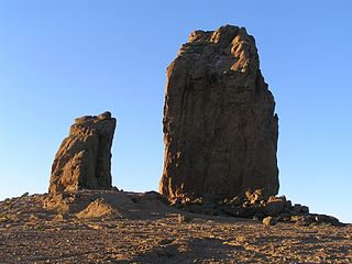
WRoque Nublo is a volcanic rock on the island of Gran Canaria, Canary Islands, Spain. It is 67 m (220 ft) tall, and its top is 1,813 m (5,948 ft) above sea level. The Roque Nublo is the third altitude of the island of Gran Canaria, after the Morro de la Agujereada with 1,956 meters, and the Pico de las Nieves with 1,949 meters.
 W
WSan Bartolomé is a town and municipality in the Canary Islands (Spain) situated in the centre of the island of Lanzarote. The municipality of San Bartolomé stretches to the southeastern coast of the island.
 W
WSan Fernando is the northern quarter of Maspalomas in the municipality of San Bartolomé de Tirajana, Gran Canaria, and as well the name of the parish for all of Maspalomas. The patron saint San Fernando was a king of Castile and famous for successful re-Christianization after the Islamic conquest of Hispania in 710.
 W
WLa Santa is a village in Tinajo, Las Palmas province of western Lanzarote in the Canary Islands. The village has a small harbor and is a popular spot for water sports.
 W
WSonnenland is a district of Maspalomas in the south of Gran Canaria, set on a hillside above Maspalomas and Playa del Inglés. Originally designed for expatriates, it is gradually becoming home to a growing number of Spanish residents, many of whom work in the surrounding tourist areas such as Arguineguín, Maspalomas, and Puerto Rico.
 W
WTabayesco is a village in the municipality of Haría in the Las Palmas province of northern Lanzarote in the Canary Islands.
 W
WTeneguía is a monogenetic cinder cone – a vent which has been active once and is considered as being unlikely to become active in the future. It is situated on the island of La Palma, one of the Canary Islands and is located at the southern end of the sub-aerial section of the Cumbre Vieja volcano of which Teneguía is just one of several vents.
 W
WTías is a town and a municipality in the southern part of the island of Lanzarote, province of Las Palmas, autonomous community of the Canary Islands, Spain. The town Tías is situated 4 km from the south coast and 10 km west of the island capital Arrecife.
WTimanfaya National Park is a Spanish national park in the southwestern part of the island of Lanzarote, in the Canary Islands. It covers parts of the municipalities Tinajo and Yaiza. The area is 51.07 square kilometres (19.72 sq mi), and the parkland is entirely made up of volcanic soil. The statue El Diablo by César Manrique is its symbol.
 W
WTinajo is a municipality in the western part of the island of Lanzarote in the Province of Las Palmas in the Canary Islands, Spain. The population is 6119 (2018), and the area is 135.28 square kilometres (52.23 sq mi). The municipality is located on the island's northwestern coast and is northwest of the island's capital, Arrecife. The main town in the municipality is Tinajo.
 W
WTomás Zerolo airfield was an aerodrome near El Médano, Granadilla de Abona, Tenerife, Canary Islands. It operated between 1962 and 1978. Only the remains of the control tower still exist.
 W
WTuineje is a town and a municipality in the southern part of the island of Fuerteventura in the Province of Las Palmas, Canary Islands, Spain. The population is 13,946 (2013), and the area is 275.94 km². The largest town in the municipality is Gran Tarajal, on the south coast.
 W
WYe is a village belonging to the municipality of Haría, on the island of Lanzarote, located at the foot of the north face of the volcano La Corona.