 W
WSeismology is the scientific study of earthquakes and the propagation of elastic waves through the Earth or through other planet-like bodies. The field also includes studies of earthquake environmental effects such as tsunamis as well as diverse seismic sources such as volcanic, tectonic, glacial, fluvial, oceanic, atmospheric, and artificial processes such as explosions. A related field that uses geology to infer information regarding past earthquakes is paleoseismology. A recording of Earth motion as a function of time is called a seismogram. A seismologist is a scientist who does research in seismology.
 W
WIn geology, aseismic creep or fault creep is measurable surface displacement along a fault in the absence of notable earthquakes.
 W
WBradyseism is the gradual uplift or descent of part of the Earth's surface caused by the filling or emptying of an underground magma chamber and/or hydrothermal activity, particularly in volcanic calderas. It can persist for millennia in between eruptions and each uplift event is normally accompanied by thousands of small to moderate earthquakes. The word derives from the ancient Greek words "bradus", meaning 'slow', and "seism" meaning 'movement', and was coined by Arturo Issel in 1883.
 W
WThe brittle-ductile transition zone is the strongest part of the Earth's crust. For quartz and feldspar rich rocks in continental crust this occurs at an approximate depth of 13–18 km. At this depth rock becomes less likely to fracture, and more likely to deform ductilely by creep. This happens because the brittle strength of a material is increased by the confining pressure, whilst the ductile strength of a material decreases with increasing temperature.
 W
WA buried rupture earthquake, or blind earthquake is an earthquake with non-visible offset of the ground surface when an earthquake rupture along a fault does not affect the Earth's surface. See also blind thrust earthquake, a close concept.
 W
WIn Earth science, as opposed to Materials Science, Ductility refers to the capacity of a rock to deform to large strains without macroscopic fracturing. Such behavior may occur in unlithified or poorly lithified sediments, in weak materials such as halite or at greater depths in all rock types where higher temperatures promote crystal plasticity and higher confining pressures suppress brittle fracture. In addition, when a material is behaving ductilely, it exhibits a linear stress vs strain relationship past the elastic limit.
 W
WAn earthquake is the shaking of the surface of the Earth resulting from a sudden release of energy in the Earth's lithosphere that creates seismic waves. Earthquakes can range in size from those that are so weak that they cannot be felt to those violent enough to propel objects and people into the air, and wreak destruction across entire cities. The seismicity, or seismic activity, of an area is the frequency, type, and size of earthquakes experienced over a period of time. The word tremor is also used for non-earthquake seismic rumbling.
 W
WEarthquake engineering is an interdisciplinary branch of engineering that designs and analyzes structures, such as buildings and bridges, with earthquakes in mind. Its overall goal is to make such structures more resistant to earthquakes. An earthquake engineer aims to construct structures that will not be damaged in minor shaking and will avoid serious damage or collapse in a major earthquake. Earthquake engineering is the scientific field concerned with protecting society, the natural environment, and the man-made environment from earthquakes by limiting the seismic risk to socio-economically acceptable levels. Traditionally, it has been narrowly defined as the study of the behavior of structures and geo-structures subject to seismic loading; it is considered as a subset of structural engineering, geotechnical engineering, mechanical engineering, chemical engineering, applied physics, etc. However, the tremendous costs experienced in recent earthquakes have led to an expansion of its scope to encompass disciplines from the wider field of civil engineering, mechanical engineering, nuclear engineering, and from the social sciences, especially sociology, political science, economics, and finance.
 W
WEarthquake rotational loading indicates the excitation of structures due to the torsional and rocking components of seismic actions. Nathan M. Newmark was the first researcher who showed that this type of loading may result in unexpected failure of structures, and its influence should be considered in design codes. There are various phenomena that may lead to the earthquake rotational loading of structures, such as propagation of body wave, surface wave, special rotational wave, block rotation, topographic effect, and soil structure interaction.
 W
WThe Indian subcontinent has a history of devastating earthquakes. The major reason for the high frequency and intensity of the earthquakes is that the Indian plate is driving into Asia at a rate of approximately 47 mm/year. Geographical statistics of India show that almost 54% of the land is vulnerable to earthquakes. A World Bank and United Nations report shows estimates that around 200 million city dwellers in India will be exposed to storms and earthquakes by 2050. The latest version of seismic zoning map of India given in the earthquake resistant design code of India [IS 1893 2002] assigns four levels of seismicity for India in terms of zone factors. In other words, the earthquake zoning map of India divides India into 4 seismic zones unlike its previous version, which consisted of five or six zones for the country. According to the present zoning map, Zone 5 expects the highest level of seismicity whereas Zone 2 is associated with the lowest level of seismicity.
 W
WIn geology, the elastic-rebound theory is an explanation for how energy is released during an earthquake.
 W
WThe focal mechanism of an earthquake describes the deformation in the source region that generates the seismic waves. In the case of a fault-related event it refers to the orientation of the fault plane that slipped and the slip vector and is also known as a fault-plane solution. Focal mechanisms are derived from a solution of the moment tensor for the earthquake, which itself is estimated by an analysis of observed seismic waveforms. The focal mechanism can be derived from observing the pattern of "first motions", that is, whether the first arriving P waves break up or down. This method was used before waveforms were recorded and analysed digitally and this method is still used for earthquakes too small for easy moment tensor solution. Focal mechanisms are now mainly derived using semi-automatic analysis of the recorded waveforms.
 W
WGeomorphology is the scientific study of the origin and evolution of topographic and bathymetric features created by physical, chemical or biological processes operating at or near the Earth's surface. Geomorphologists seek to understand why landscapes look the way they do, to understand landform history and dynamics and to predict changes through a combination of field observations, physical experiments and numerical modeling. Geomorphologists work within disciplines such as physical geography, geology, geodesy, engineering geology, archaeology, climatology and geotechnical engineering. This broad base of interests contributes to many research styles and interests within the field.
 W
WGlacial earthquakes are earthquakes as large as magnitude 5.1 that occur in glaciated areas where the glacier moves faster than one kilometer per year.
 W
WIn seismology, the Gutenberg–Richter law expresses the relationship between the magnitude and total number of earthquakes in any given region and time period of at least that magnitude.
 W
WA harmonic tremor is a sustained release of seismic and infrasonic energy typically associated with the underground movement of magma, the venting of volcanic gases from magma, or both. It is a long-duration release of seismic energy, with distinct spectral lines, that often precedes or accompanies a volcanic eruption. More generally, a volcanic tremor is a sustained signal that may or may not possess these harmonic spectral features. Being a long-duration continuous signal from a temporally extended source, a volcanic tremor contrasts distinctly with transient sources of seismic radiation, such as tremors that are typically associated with earthquakes and explosions.
 W
WA hypocenter is the point of origin of an earthquake or a subsurface nuclear explosion. In seismology, it is a synonym of the focus. The term hypocenter is also used as a synonym for ground zero, the surface point directly beneath a nuclear airburst.
 W
WThe Insheim Geothermal Power Station is a geothermal power station in Rhineland-Palatinate.
International Association of Seismology and Physics of the Earth's Interior (IASPEI) is an international organization that promotes study of earthquakes and other seismic sources, propagation of seismic waves, and the internal structure, properties and processes of the Earth.
 W
WIn seismology, an isoseismal map is used to show lines of equally felt seismic intensity, generally measured on the Modified Mercalli scale. Such maps help to identify earthquake epicenters, particularly where no instrumental records exist, such as for historical earthquakes. They also contain important information on ground conditions at particular locations, the underlying geology, radiation pattern of the seismic waves, and the response of different types of buildings. They form an important part of the macroseismic approach, i.e. that part of seismology dealing with noninstrumental data. The shape and size of the isoseismal regions can be used to help determine the magnitude, focal depth, and focal mechanism of an earthquake.
 W
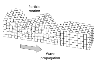
WIn elastodynamics, Love waves, named after Augustus Edward Hough Love, are horizontally polarized surface waves. The Love wave is a result of the interference of many shear waves (S-waves) guided by an elastic layer, which is welded to an elastic half space on one side while bordering a vacuum on the other side. In seismology, Love waves are surface seismic waves that cause horizontal shifting of the Earth during an earthquake. Augustus Edward Hough Love predicted the existence of Love waves mathematically in 1911. They form a distinct class, different from other types of seismic waves, such as P-waves and S-waves, or Rayleigh waves. Love waves travel with a lower velocity than P- or S- waves, but faster than Rayleigh waves. These waves are observed only when there is a low velocity layer overlying a high velocity layer/ sub–layers.
 W
WLunar seismology is the study of ground motions of the Moon and the events, typically impacts or moonquakes, that excite them.
 W
WA marsquake is a quake which, much like an earthquake, would be a shaking of the surface or interior of the planet Mars as a result of the sudden release of energy in the planet's interior, such as the result of plate tectonics, which most quakes on Earth originate from, or possibly from hotspots such as Olympus Mons or the Tharsis Montes. The detection and analysis of marsquakes could be informative to probing the interior structure of Mars, as well as identifying whether any of Mars's many volcanoes continue to be volcanically active or not.
 W
WAn important parameter in the calculation of seismic hazard, maximum magnitude is also one of the more contentious. The choice of the value can greatly influence the final outcome of the results, yet this is most likely a size of earthquake that has not yet occurred in the region under study.
 W
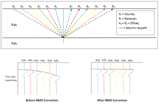
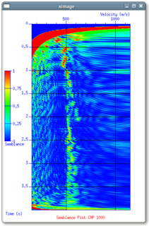
WIn reflection seismology, normal moveout (NMO) describes the effect that the distance between a seismic source and a receiver has on the arrival time of a reflection in the form of an increase of time with offset. The relationship between arrival time and offset is hyperbolic and it is the principal criterion that a geophysicist uses to decide whether an event is a reflection or not. It is distinguished from dip moveout (DMO), the systematic change in arrival time due to a dipping layer.
 W
WA P-wave or a primary wave is one of the two main types of elastic body waves, called seismic waves in seismology. P-waves travel faster than other seismic waves and hence are the first signal from an earthquake to arrive at any affected location or at a seismograph. P-waves may be transmitted through gases, liquids, or solids.
 W
WPlate tectonics is a scientific theory describing the large-scale motion of seven large plates and the movements of a larger number of smaller plates of Earth's lithosphere, since tectonic processes began on Earth between 3.3 and 3.5 billion years ago. The model builds on the concept of continental drift, an idea developed during the first decades of the 20th century. The geoscientific community accepted plate-tectonic theory after seafloor spreading was validated in the late 1950s and early 1960s.
Republican Seismic Survey Center (RSSC) is the main organization, involved in the research and study of earthquakes on the territory of Azerbaijan Republic. Seismological, geophysical, geochemical and geodynamic complex researches are conducted in the Center.
 W
WIn the oil and gas industry, reservoir modeling involves the construction of a computer model of a petroleum reservoir, for the purposes of improving estimation of reserves and making decisions regarding the development of the field, predicting future production, placing additional wells, and evaluating alternative reservoir management scenarios.
 W
WRotational components of strong ground motions refer to changes of the natural slope of the ground surface due to the propagation of seismic waves. Earthquakes induce three translational and three rotational motions on the ground surface. To study the nature of strong ground motions, seismologists and earthquake engineers deploy accelerometers and seismometers near active faults on the ground surface in order to record the translational motions of ground shaking. The corresponding rotational motions are, then, estimated in terms of the gradient of the recorded translational ground motions. Different methods may be adopted for the indirect estimation of the earthquake rotational components, such as time derivation and finite difference. Recently, a limited number of advanced instruments, named ring laser gyroscopes, have been used to detect rotational movements of the ground surface, and directly measure the amplitude of the rotational components of strong ground motions
 W
WIn seismology, S-waves, secondary waves, or shear waves are a type of elastic wave and are one of the two main types of elastic body waves, so named because they move through the body of an object, unlike surface waves.
 W
WSand boils or sand volcanoes occur when water under pressure wells up through a bed of sand. The water looks like it is boiling up from the bed of sand, hence the name.
 W
WA sand geyser, sand fountain or sand blow is a geologic phenomena which occurs in association with earthquakes and other seismic events. In the geologic record, these are seen as clastic dikes. It is described as "a geyser of sand and water that shoots from the ground during a major earthquake." A quake can cause underlying sand to liquefy while pressure forces the eruption of the sand mixture to the surface. The mixture of sand and water can also contain dissolved gases such as methane and carbon dioxide.
 W
WSeismic or vibrational communication is a process of conveying information through mechanical (seismic) vibrations of the substrate. The substrate may be the earth, a plant stem or leaf, the surface of a body of water, a spider's web, a honeycomb, or any of the myriad types of soil substrates. Seismic cues are generally conveyed by surface Rayleigh or bending waves generated through vibrations on the substrate, or acoustical waves that couple with the substrate. Vibrational communication is an ancient sensory modality and it is widespread in the animal kingdom where it has evolved several times independently. It has been reported in mammals, birds, reptiles, amphibians, insects, arachnids, crustaceans and nematode worms. Vibrations and other communication channels are not necessarily mutually exclusive, but can be used in multi-modal communication.
 W
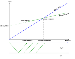
WSeismic refraction is a geophysical principle governed by Snell's Law of refraction. The seismic refraction method utilizes the refraction of seismic waves by rock or soil layers to characterize the subsurface geologic conditions and geologic structure.
 W
WSeismic Unix is an open source seismic utilities package which was supported by the Center for Wave Phenomena (CWP) at the Colorado School of Mines (CSM). Currently it is supported by John Stockwell.
 W
WA seismic vibrator is a truck-mounted or buggy-mounted device that is capable of injecting low-frequency vibrations into the earth. It is one of a number of seismic sources used in reflection seismology. The ‘Vibroseis’ exploration technique was developed by the Continental Oil Company (Conoco) during the 1950s and was a trademark until the company's patent lapsed.
 W
WSeismic waves are waves of energy that travel through Earth's layers, and are a result of earthquakes, volcanic eruptions, magma movement, large landslides and large man-made explosions that give out low-frequency acoustic energy. Many other natural and anthropogenic sources create low-amplitude waves commonly referred to as ambient vibrations. Seismic waves are studied by geophysicists called seismologists. Seismic wave fields are recorded by a seismometer, hydrophone, or accelerometer.
 W
WSeismites are sedimentary beds and structures deformed by seismic shaking. The German paleontologist Adolf Seilacher first used the term in 1969 to describe earthquake-deformed layers. Today, the term is applied to both sedimentary layers and soft sediment deformation structures formed by shaking. This subtle change in usage accommodates structures that may not remain within a layer.
WA seismic shadow zone is an area of the Earth's surface where seismographs can only barely detect an earthquake after its seismic waves have passed through the Earth. When an earthquake occurs, seismic waves radiate out spherically from the earthquake's focus. The primary seismic waves are refracted by the liquid outer core of the Earth and are not detected between 104° and 140° from the epicenter. The secondary seismic waves cannot pass through the liquid outer core and are not detected more than 104° from the epicenter. P-waves that have been converted to S-waves on leaving the outer core may be detected beyond 140 degrees.
 W
WShear wave splitting, also called seismic birefringence, is the phenomenon that occurs when a polarized shear wave enters an anisotropic medium. The incident shear wave splits into two polarized shear waves. Shear wave splitting is typically used as a tool for testing the anisotropy of an area of interest. These measurements reflect the degree of anisotropy and lead to a better understanding of the area's crack density and orientation or crystal alignment. We can think of the anisotropy of a particular area as a black box and the shear wave splitting measurements as a way of looking at what is in the box.
 W
WSoil liquefaction occurs when a saturated or partially saturated soil substantially loses strength and stiffness in response to an applied stress such as shaking during an earthquake or other sudden change in stress condition, in which material that is ordinarily a solid behaves like a liquid. In soil mechanics, the term "liquefied" was first used by Allen Hazen in reference to the 1918 failure of the Calaveras Dam in California. He described the mechanism of flow liquefaction of the embankment dam as:If the pressure of the water in the pores is great enough to carry all the load, it will have the effect of holding the particles apart and of producing a condition that is practically equivalent to that of quicksand… the initial movement of some part of the material might result in accumulating pressure, first on one point, and then on another, successively, as the early points of concentration were liquefied.
 W
WSpectral acceleration (SA) is a unit measured in g that describes the maximum acceleration in an earthquake on an object – specifically a damped, harmonic oscillator moving in one physical dimension. This can be measured at different oscillation frequencies and with different degrees of damping, although 5% damping is commonly applied. The SA at different frequencies may be plotted to form a response spectrum.
 W
WIn seismology, strong ground motion is the strong earthquake shaking that occurs close to a causative fault. The strength of the shaking involved in strong ground motion usually overwhelms a seismometer, forcing the use of accelerographs for recording. The science of strong ground motion also deals with the variations of fault rupture, both in total displacement, energy released, and rupture velocity.
 W
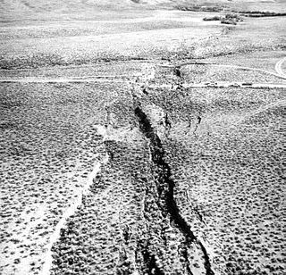
WSurface rupture is the visible offset of the ground surface when an earthquake rupture along a fault affects the Earth's surface. Surface rupture is opposed by buried rupture, where there is no displacement at ground level. This is a major risk to any structure that is built across a fault zone that may be active, in addition to any risk from ground shaking. Surface rupture entails vertical or horizontal movement, on either side of a ruptured fault. Surface rupture can affect large areas of land.
 W
WIn physics, a surface wave is a mechanical wave that propagates along the interface between differing media. A common example is gravity waves along the surface of liquids, such as ocean waves. Gravity waves can also occur within liquids, at the interface between two fluids with different densities. Elastic surface waves can travel along the surface of solids, such as Rayleigh or Love waves. Electromagnetic waves can also propagate as "surface waves" in that they can be guided along with a refractive index gradient or along an interface between two media having different dielectric constants. In radio transmission, a ground wave is a guided wave that propagates close to the surface of the Earth.
 W
WA thrust fault is a break in the Earth's crust, across which older rocks are pushed above younger rocks.
 W
WThe University of Queensland Seismology Station was established in 1938 at the University of Queensland, Brisbane, Australia.