 W
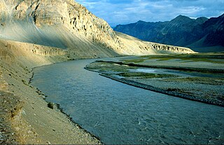
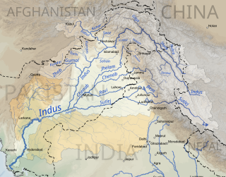
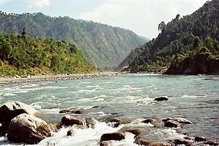
WThe Indus River is one of the main rivers of the Indo-Gangetic Plain in the Indian subcontinent. It flows through China, India, and Pakistan. Originating in the Tibetan Plateau in the vicinity of Lake Manasarovar, the river runs a course through the Ladakh region of India towards Gilgit-Baltistan, and then flows in a southerly direction along the entire length of Pakistan to merge into the Arabian Sea near the port city of Karachi in Sindh. The Indus is the longest river of Pakistan.
 W
WBaspa River rises near the Indo-Tibetan border and forms the Baspa Valley - one of the most scenic in Himalayas. The Chung Sakhago Pass lies at the head of the valley. It is fed by the perennial glaciers and shares the catchment area with the Ganges.
 W
WThe Beas River is a river in north India. The river rises in the Himalayas in central Himachal Pradesh, India, and flows for some 470 kilometres (290 mi) to the Sutlej River in the Indian state of Punjab. Its total length is 470 kilometres (290 mi) and its drainage basin is 20,303 square kilometres (7,839 sq mi) large.
 W
WThe Braldu River flows in the Skardu District of Gilgit Baltistan in Pakistan. The Braldu River joins the Basha Basna River, and together they form the Shigar River, which is a tributary of the Indus River.
 W
WBudki Nadi, sometimes called the Budki torrent, is a seasonal, monsoon-driven rivulet in the Indian state of Punjab. It begins in the Shivalik Hills of the lower Himalayas and flows in a southwest direction to eventually join the Sutlej River.
 W
WChang Chenmo River or Changchenmo River is a tributary of the Shyok River, part of the Indus River system. It is at the southern edge of the disputed Aksai Chin region and north of the Pangong Lake basin.
WThe Charding Nullah, traditionally known as the Lhari stream and called the Demchok River by China, is a small river that originates near the Charding La pass that is also on the border between the two countries and flows northeast to join the Indus River near a peak called "Lhari Karpo". There are villages on both sides of the mouth of the river, romanised as Demchok and Dêmqog. The river serves as the de facto border between China and India in the Demchok sector.
 W
WThe Chautang, originating in Siwalik Hills, is a tributary of Sarsuti river which in turn is tributary of Ghaggar river in of Haryana state of India.
 W
WThe Chenab River is a major river that flows in India and Pakistan, and is one of the 5 major rivers of the Punjab region. It rises in the upper Himalayas in the Lahaul and Spiti district of Himachal Pradesh state, India, and flows through the Jammu region of Jammu and Kashmir into the plains of Punjab, Pakistan, before flowing into the Indus River near the city of Uch Sharif. The waters of the Chenab were allocated to Pakistan under the terms of the Indus Waters Treaty.
WThe Tangri River, also called the Dangri River, which originates in the Shivalik Hills, is a tributary of the Ghaggar River in the Haryana state of India.
 W
WThe Doda River or the Stod River is a river 79 kilometres (49 mi) long, which forms the Stod Valley in the Zanskar valley of the Leh district in the Union Territory of Ladakh.
 W
WThe Dras River, also spelt Drass River, is a river in the Kargil district in the Indian union territory of Ladakh. It originates below the Zoji La pas in the Great Himalayan range and flows northeast towards Kargil, where it joins the Suru River. The Shingo River, which flows in a parallel direction in Pakistan-administered Baltistan, also joins the Drass River. The combined river is alternatively called Suru, Drass and Shingo by various local groups.
 W
WThe Ghaggar-Hakra River is an intermittent river in India and Pakistan that flows only during the monsoon season. The river is known as Ghaggar before the Ottu barrage and as the Hakra downstream of the barrage. The Hakra river is hydraulically connected to the Nara River provided it has adequate flow to maintain surface flow. After the construction of the Otu Barrage, the downstream Hakra river dried up fully but subsurface flow is maintained to the Nara river which becomes later the delta channel of the Indus River before joining the sea via Kori Creek in Gujarat state.
 W
WThe Kaushalya river, a tributary of Ghaggar river, is a river in Panchkula district of Haryana state of India.
 W
WThe Markanda river in Himachal Pradesh and Haryana states of India is a tributary of Ghaggar river, flowing through Sirmaur District, Ambala district and Shahabad Markanda town in Kurukshetra district. The Markanda river's ancient name was Aruna.
 W
WHaro is the name of a river that flows through Khyber Pakhtunkhwa and parts of Punjab. Its main valley is in Abbottabad District in the Hazara Division of Khyber Pakhtunkhwa province, northern Pakistan. The famous Khanpur Dam has been built on this river at Khanpur in the Haripur District of Hazara Division to provide drinking water to the twin cities i.e. Islamabad and Rawalpindi. The decrease in inflows of Khanpur dam from Haro River results in water shortage in the twin cities during summer season.
 W
WThe Indus Basin Project is a water control project that resulted from a treaty, Indus Waters Treaty, signed between India and Pakistan in 1960 that guaranteed that Pakistan would receive water from the Indus River independent from upstream control by India.
 W
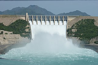
WThe Indus Basin Replacement Works, also known as the Indus Basin Settlement Plan, was carried out in Pakistan's Indus Basin Irrigation System, which is one of the world's largest continuous irrigation systems. The replacement works were implemented to provide Pakistan with enough water for irrigation needs following the Indus Waters Treaty between India and Pakistan. The treaty gave the rights to three eastern rivers of the Indus Basin to India, and to make up for this loss of water a network of dams and link canals was built to haul water from the western Indus tributaries Jhelum and Chenab to the eastern Ravi, Sutlej and Beas rivers. The government of Pakistan built the Tarbela Dam and Mangla Dam and a number of barrages now managed by Punjab Irrigation Department under the Indus Basin Replacement Works. Eight inter-river canals were also built between western and eastern rivers. It is due to the connectivity between these rivers that Pakistan's irrigation system is called a contiguous irrigation system.
 W
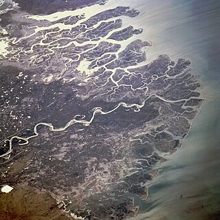
WThe Indus River Delta, forms where the Indus River flows into the Arabian Sea, mostly in the southern Sindh province of Pakistan with a small portion in the Kutch Region of the western tip of India. The delta covers an area of about 41,440 km2, and is approximately 210 km (130 mi) across where it meets the sea. The active part of the delta is 6,000 km2 in area (2,300 sq mi). The climate is arid, the region only receives between 25 and 50 centimetres of rainfall in a normal year. The delta is home to the largest arid mangrove forests in the world, as well as many birds, fish and the Indus dolphin.
 W
WThe Indus Waters Treaty is a water-distribution treaty between India and Pakistan, brokered by the World Bank, to use the water available in the Indus River and its tributaries. The Indus Waters Treaty (IWT) was signed in Karachi on 19 September 1960 by Pandit Jawaharlal Nehru and Ayub Khan.
 W
WThe Kabul River, the classical Cophen, is a 700-kilometre-long (430 mi) river that emerges in Maidan Wardak Province in the Sanglakh Range of the Hindu Kush mountains in Afghanistan, and is separated from the watershed of the Helmand River by the Unai Pass. The Kabul River empties into the Indus River near Attock, Pakistan. It is the main river in eastern Afghanistan and the Khyber Pakhtunkhwa province of Pakistan.
 W
WThe Korang River is a stream in Punjab, Pakistan. It originates from Murree Hills and flows towards Islamabad. Korang Stream along with some other small streams coming from Margalla Hills have been set to form the artificial Rawal Lake in Islamabad. Korang River is the outlet stream of Rawal Dam. This stream crosses Islamabad Express Highway from between Korang Town and Judicial Colony. The terrain of this stream is eye catching and the Loi Bhair Wildlife Safari Park is located on the beautiful terrain of the left bank of Korang Stream. Onward, this stream joins Soan River before reaching the Grand Trunk Road. Just after this point, Lai Nullah also joins Soan River.
 W
WThe Kunhar River or River Kunhar, is 166 kilometres (103 mi) long river, located primarily in the Khyber Pakhtunkhwa province, northern Pakistan. It is in the Indus River watershed basin.
 W
WThe Landai Sin River, also called the Bashgal River, is located in eastern Afghanistan. It rises in the Hindu Kush range near the Mandol Pass in the Nuristan Province of Afghanistan, and is fed from glaciers and snow to its north.
 W
WLidder or Liddar is a 73 kilometres (45 mi) long river in the Kashmir region of India in the union territory of Jammu and Kashmir. It originates from the Kolhoi Glacier and joins the Jehlum River at Mirgund Khanabal at an altitude of 1,615 metres (5,299 ft).
 W
WThe Ling Stream flows in the Pothohar region of Northern Pakistan. It starts in the foothills of the Lhetrar area near Kahuta and, flowing and cutting its way through the hilly area, it meets the Swan River near Sihala. The road that joins Islamabad and Azad Kashmir passes it twice. Kingfishers also hunt fish at this stream.
 W
WLake Manasarovar or Manas Sarovar, also called Swan rimbonche(Tibetan: མ་ཕམ་གཡུ་མཚོ།, Wylie: ma pham g.yu mtsho; ; is a high altitude freshwater lake fed by the Kailash Glaciers near Mount Kailash in Burang County, Ngari Prefecture, Tibet Autonomous Region, China. The lake is revered as a sacred place in four religions: Bön, Buddhism, Hinduism and Jainism.
 W
WThe Manawar Tawi river is a tributary of the Chenab River, which originates at the Ratan Pir ridge of the Pir Panjal Range and flows through the Rajouri and Jammu districts of Jammu and Kashmir and the Narowal district of Pakistani Punjab, where it joins the Chenab. The towns along its course include Thana Mandi, Rajouri and Naushera. Towards the end of its course, it flows through the plains of the Jammu district west of Akhnur close to the Line of Control dividing the Pakistan-administered and Indian-administered Kashmir regions.
 W
WThe Neelum River, or Kishanganga, is a river in the Kashmir region of India and Pakistan; it starts in the Indian city of Gurais and then merges with the Jhelum River near the Pakistani city of Muzaffarabad.
 W
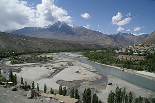
WNubra is a subdivision and a tehsil in the Indian union territory of Ladakh. Its inhabited areas form a tri-armed valley cut by the Nubra and Shyok rivers. Its Tibetan name Ldumra means "the valley of flowers". Demands have been raised and BJP has hinted at creation of Nubra as a new district. Diskit, the headquarters of Nubra, is about 150 km north from Leh, the capital of Ladakh.
 W
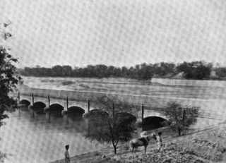
WPanjnad area is located in Punjab, Pakistan. It is an agricultural area near Uchh, Bahawalpur and it is where all the five rivers of Punjab merge. It is a beautiful picnic point and known for its fresh fish. One kilometer south east is Nalka Adda where you can find a good marketplace. At Nalka Adda there is Dada Dadi free medical dispensary supervised by professor paediatric medicine Dr Muhammad Azam Khan Gabol. Panjnad Headworks or Panjnad barrage has three canals namely Panjnad canal, Abbassia canal, and Abbassia link canal .recentally 2020 head punjnad barrage remodelling done .now its capacity to pass water is increased and semi automatic control of gates installed.These canals irrigate Bahawalpur and Rahim Yar Khan districts and the northern Sindh area.
 W
WThe Parang River is an upstream tributary of the Sutlej River, that originates in the Indian state of Himachal Pradesh and ends in Himachal Pradesh again, but flows through Ladakh and Tibet before doing so. The origin of the river is near the Parang La pass in the Spiti subdistrict. After its circuitous journey, it joins the Spiti River near Sumdo and the combined river then joins Sutlej.
 W
WParvati River is a river in the Parvati Valley in Himachal Pradesh, northern India that flows into the Beas River at Bhuntar, some 10 km south of Kullu. It rises from the Man Talai Glacier below the Pin Parbati pass and flows in a gradual curve from north-northwest to west-southwest past the important temple town of Manikaran.
 W
WLake Rakshastal is a lake in Tibet Autonomous Region, China, lying just west of Lake Manasarovar and south of Mount Kailash. The Sutlej River originates at Rakshastal's northwestern tip. Despite its close proximity to Lake Manasarovar, Lake Rakshastal does not share the historic religious significance of its eastern neighbor.
 W
WRambi Ara is a river and tributary to the River Jhelum located in Shopian District in the union territory of Jammu and Kashmir. It joins the Veshaw River near Sangam in Anantnag District before the confluence finally meets the Jhelum. The Rambi Ara originates in the Pir Panjal Range and has two major tributaries. The Rambi Ara is known for fluctuating water levels and is often affected by flash floods.
 W
WThe Ravi River is a transboundary river crossing northwestern India and eastern Pakistan. It is one of six rivers of the Indus System in Punjab region.
 W
WThe Rupal River is an east-west glacial stream rising from the meltwater of the Rupal Glacier in northern Pakistan. The stream flows through the Rupal Valley, south of Nanga Parbat, before turning northeast to the village of Tarashing. The Rupal drains into the Astore River, which eventually reaches the Indus near Jaglot.
 W
WThe Sahibi river, also called the Sabi River, is an ephemeral, rain-fed river flowing through Rajasthan, Haryana and Delhi states in India. It drains into Yamuna in Delhi, where its channeled course is also called the Najafgarh drain, which also serves as Najafgarh drain bird sanctuary. Sahibi is a seasonal river which is 300 km long and flows from Aravalli hills in Rajasthan to Haryana, of which 100 km is in Haryana.
WThe Sarsuti river, originating in Siwalik Hills and flowing through the palaeochannel of Yamuna, is a tributary of Ghaggar river in of Haryana state of India. Its course is dotted with archaeological and religious sites dating back to post-Harrapan Mahabharata sites from Vedic period, such as Kapal Mochan, Kurukshetra, Thanesar, Brahma Sarovar, Jyotisar, Bhor Saidan and Pehowa.
 W
WThe Shingo River is a tributary of the Indus River, and flows through Gilgit-Baltistan and Kargil regions.
 W
WThe Sind River or the Sindh River is a river in the Ganderbal district of the union territory of Jammu and Kashmir, India. It is a major tributary of the Jhelum River and is 108 kilometres long.
 W
WThe Suru River, a obsequent tributary of Indus flows from West to East direction, is a river in Kargil district of Ladakh in India and Skardu District of Baltistan in Pakistan.
 W
WThe Sutlej River is the longest of the five rivers that flow through the historic crossroads region of Punjab in northern India and Pakistan. The Sutlej River is also known as Satadree. It is the easternmost tributary of the Indus River.The bhakra dam is built around the river Sutlej to provide irrigation and other facilities to the nearby areas.
 W
WSwat District is a district in Malakand Division of Khyber Pakhtunkhwa province in Pakistan. Centred upon the upper portions of the Swat River, Swat was a major centre of early Buddhist thought as part of the Gandhara kingdom, and today is littered with ruins from that era. Swat was home to the last isolated pockets of Gandharan Buddhism, which lasted until the 10th century, well after most of the area had converted to Islam. Until 1969, Swat was part of the Yusafzai State of Swat, a self-governing princely state. The region was seized by the Pakistani Taliban in late 2007, and its tourist industry decimated until Pakistani control over Swat was re-established in mid 2009.
 W
WThe Tsarap River or the Tsarap Chu, is a river 182 kilometres (113 mi) long, which forms the eastern part of the Zanskar valley, in the Ladakh union territory of India.
 W
WThe Uhl is a Himalayan river which is part of the watershed of Beas river. The river originates at the Thamsar Glacier in the Dhauladhar range of the Himalayas, flows through the Uhl valley crossing the villages Bada Gran (Baragram) and Barot. In its lower course, it is also known as Tiun Nala and the Uhl valley is known as Chohar valley. After passing the Chohar valley, the Uhl meets the Beas river 5 km downstream from Pandoh.
 W
WThe Valley of Peshawar or Greater Peshawar is a broad valley situated in the central part of the Khyber Pakhtunkhwa province of Pakistan. The valley is 7,176 km2 (2,771 sq mi) in area, and is traversed by the Kabul River. It has a mean elevation of 345 metres (1,132 ft). The valley takes its name from the city of Peshawar, which is situated at the western part of the valley close to Warsak Dam. To the west of the valley lies the Khyber Pass. The five most populous cities in the valley are Peshawar, Mardan, Swabi, Charsadda, and Nowshera.
 W
WThe Veshaw River is a major tributary to the River Jhelum located in Kulgam District in the Kashmir Valley in the union territory of Jammu and Kashmir, India. It originates in the Pir Panjal Range and forms a waterfall at Aharbal.
 W
WZhob River is located in Balochistan and Khyber Pakhtunkhwa, Pakistan. The total length of the Zhob River is 410 km, and it flows on a generally northeasterly course.