 W
WA ship canal is a canal especially intended to accommodate ships used on the oceans, seas, or lakes to which it is connected.
 W
WThe Baillie-Grohman Canal was a shipping canal between the headwaters of the Columbia River and the upper Kootenay River in the East Kootenay region of British Columbia at a place now known as Canal Flats, BC. The construction of the canal was required by the provincial government of British Columbia as a condition of the canal's promoter receiving substantial land concessions from the provincial government of British Columbia in the area of Creston, BC. The promoter, William Adolf Baillie-Grohman (1851–1921), was a wealthy adventurer, hunter author, and business promoter. He declared the canal to be complete in 1889. The canal was an expensive failure, being used only three times during its entire existence. In 1902, on the last use by a vessel, the sternwheeler North Star, the sternwheeler's captain, Frank P. Armstrong deliberately blew out the canal's lower lock gates with dynamite to allow the transit of his vessel.
 W
WThe Bảo Định canal also called the Bảo Định river is a part-natural, part-man made waterway in the Mekong Delta in Vietnam. It is in places also named the Vũng Gù canal (kênh Vũng Gù,.
 W
WThe Caledonian Canal connects the Scottish east coast at Inverness with the west coast at Corpach near Fort William in Scotland. The canal was constructed in the early nineteenth century by Scottish engineer Thomas Telford.
 W
WThe Canso Canal is a short canal located in Nova Scotia, Canada.
 W
WThe Cape Cod Canal is an artificial waterway in the U.S. state of Massachusetts connecting Cape Cod Bay in the north to Buzzards Bay in the south, and is part of the Atlantic Intracoastal Waterway. The approximately seven-mile-long (11 km) canal traverses the narrow neck of land joining Cape Cod to the state's mainland. Most of its length follows tidal rivers widened to 480 feet (150 m) and deepened to 32 feet (9.8 m) at mean low water, shaving 135 miles (217 km) off the journey around the Cape for its approximately 14,000 annual users.
 W
WThe Chesapeake & Delaware Canal is a 14-mile (22.5 km)-long, 450-foot (137.2 m)-wide and 35-foot (10.7 m)-deep ship canal that connects the Delaware River with the Chesapeake Bay in the states of Delaware and Maryland in the United States. The C&D Canal is owned and operated by the U.S. Army Corps of Engineers, Philadelphia District. The project office in Chesapeake City, Maryland, is also the site of the C&D Canal Museum and Bethel Bridge Lighthouse. The canal saves approximately 300 miles on the route between Wilmington and Baltimore, and similar for Philadelphia to Baltimore, whereas otherwise ships would have to go around the lower peninsula of Delaware.
 W
WThe Chicago Sanitary and Ship Canal, historically known as the Chicago Drainage Canal, is a 28-mile-long (45 km) canal system that connects the Chicago River to the Des Plaines River. It reverses the direction of the Main Stem and the South Branch of the Chicago River, which now flows out of Lake Michigan rather than into it. The related Calumet-Saganashkee Channel does the same for the Calumet River a short distance to the south, joining the Chicago canal about halfway along its route to the Des Plaines. The two provide the only navigation for ships between the Great Lakes Waterway and the Mississippi River system.
 W
WThe Corinth Canal connects the Gulf of Corinth in the Ionian Sea with the Saronic Gulf in the Aegean Sea. It cuts through the narrow Isthmus of Corinth and separates the Peloponnese from the Greek mainland, arguably making the peninsula an island. The canal was dug through the isthmus at sea level and has no locks. It is 6.4 kilometres (4 mi) in length and only 21.4 metres (70 ft) wide at its base, making it impassable for many modern ships. It has little economic importance and is mainly a tourist attraction.
 W
WThe Crinan Canal between Crinan and Ardrishaig in Argyll and Bute in the west of Scotland is operated by Scottish Canals. The canal, which opened in 1801, takes its name from the village of Crinan at its western end. Approximately nine miles (14 km) long, the canal connects the village of Ardrishaig on Loch Gilp with the Sound of Jura, providing a navigable route between the Clyde and the Inner Hebrides, without the need for a long diversion around the Kintyre peninsula, and in particular the exposed Mull of Kintyre.
 W
WThe Danube–Black Sea Canal is a navigable canal in Romania, which runs from Cernavodă on the Danube river, via two branches, to Constanța and Năvodari on the Black Sea. Administrated from Agigea, it is an important part of the waterway link between the North Sea and the Black Sea via the Rhine–Main–Danube Canal. The main branch of the canal, with a length of 64.4 km (40.0 mi), which connects the Port of Cernavodă with the Port of Constanța, was built in two periods, 1949–1953 and 1973–1984, while the northern branch, known as the Poarta Albă–Midia Năvodari Canal, with a length of 31.2 km (19.4 mi), connecting Poarta Albă and the Port of Midia, was built between 1983 and 1987.
 W
WThe Duluth Ship Canal is an artificial canal cut through Minnesota Point, providing direct access to Duluth harbor from Lake Superior. Begun privately in 1871, it was put under federal supervision and maintenance several years later. It is still an important component of the harbor facilities.
 W
WThe Eider Canal was an artificial waterway in southern Denmark which connected the North Sea with the Baltic Sea by way of the rivers Eider and Levensau. Constructed between 1777 and 1784, the Eider Canal was built to create a path for ships entering and exiting the Baltic that was shorter and less storm-prone than navigating around the Jutland peninsula. In the 1880s the canal was replaced by the enlarged Kiel Canal, which includes some of the Eider Canal's watercourse.
 W
WThe Eurasia Canal is a proposed 700-kilometre-long (430 mi) canal connecting the Caspian Sea to the Black Sea along the Kuma-Manych Depression. Currently, a chain of lakes and reservoirs and the shallow irrigation Kuma-Manych Canal are found along this route.
 W
WThe Grand Canal, known to the Chinese as the Jing–Hang Grand Canal, a UNESCO World Heritage Site, is the longest canal or artificial river in the world. Starting in Beijing, it passes through Tianjin and the provinces of Hebei, Shandong, Jiangsu, and Zhejiang to the city of Hangzhou, linking the Yellow River and Yangtze River. The oldest parts of the canal date back to the 5th century BC, but the various sections were first connected during the Sui dynasty. Dynasties in 1271–1633 significantly restored and rebuilt the canal and altered its route to supply their capital.
 W
WThe Hamilton Canal is a 14.5 km (9.0 mi) canal connecting Puttalam to Colombo, passing through Negombo in Sri Lanka. The canal was constructed by the British in 1802 and completed in 1804. It was designed to drain salt water out of the Muthurajawela wetlands. The canal was named after Gavin Hamilton, the Government Agent of Revenue and Commerce.
 W
WThe Houston Ship Channel, in Houston, Texas, is part of the Port of Houston, one of the busiest seaports in the world. The channel is the conduit for ocean-going vessels between Houston-area terminals and the Gulf of Mexico, and it serves an increasing volume of inland barge traffic.
 W
WThe Hurden ship canal is a 500-metre (1,600 ft) long canal in the Swiss canton of Schwyz. It connects the lower section of Lake Zürich with the upper section, sometimes called the Obersee, permitting shipping services on the lake to pass between the two halves of the lake without passing through the shallows, and under the low bridges, of the Seedamm. The canal was opened in 1943, and cuts through the base of the peninsular containing the village of Hurden, thus placing the centre of the village on an artificial island.
 W
WThe Illinois and Michigan Canal connected the Great Lakes to the Mississippi River and the Gulf of Mexico. In Illinois, it ran 96 miles (154 km) from the Chicago River in Bridgeport, Chicago to the Illinois River at LaSalle-Peru. The canal crossed the Chicago Portage, and helped establish Chicago as the transportation hub of the United States, before the railroad era. It was opened in 1848. Its function was largely replaced by the wider and shorter Chicago Sanitary and Ship Canal in 1900, and it ceased transportation operations with the completion of the Illinois Waterway in 1933.
 W
WThe Interlaken ship canal is a 2.75-kilometre (1.71 mi) long canal in the Swiss canton of Bern. It connects Lake Thun with a quay in the town of Interlaken adjacent to Interlaken West railway station, thus allowing shipping services on the lake to serve the town and connect with railway services. It is still in regular use by the Lake Thun passenger ships of the BLS AG.
 W
WKali Besar refers to the channel connecting Sunda Kelapa in the north to the south part in old town of Jakarta, parallel to Ciliwung River in their east disemboguing at the heart of the old city of Jakarta. Literally meaning Grand River, this channel is now part of Kali Krukut in Tambora subdistrict.
 W
WThe Kiel Canal is a 98-kilometre-long (61 mi) freshwater canal in the German state of Schleswig-Holstein. The canal was finished in 1895, but later widened, and links the North Sea at Brunsbüttel to the Baltic Sea at Kiel-Holtenau. An average of 250 nautical miles (460 km) is saved by using the Kiel Canal instead of going around the Jutland Peninsula. This not only saves time but also avoids storm-prone seas and having to pass through the Danish straits.
 W
WThe Lake Champlain Seaway was a canal project proposed in the late 19th century and considered as late as the 1960s to connect New York State's Hudson River and Quebec's St. Lawrence River with a deep-water canal. The objective was to allow easy ship traffic from New York City to Montreal through Lake Champlain, lowering transportation costs between the two cities.
 W
WThe Lake Washington Ship Canal, which runs through the city of Seattle, connects the fresh water body of Lake Washington with the salt water inland sea of Puget Sound. The Hiram M. Chittenden Locks accommodate the approximately 20-foot (6.1 m) difference in water level between Lake Washington and the sound. The canal runs east–west and connects Union Bay, the Montlake Cut, Portage Bay, Lake Union, the Fremont Cut, Salmon Bay, and Shilshole Bay, which is part of the sound.
 W
WThe Ludwig Canal, is an abandoned canal in southern Germany.
 W
WThe Manchester Ship Canal is a 36-mile-long (58 km) inland waterway in the North West of England linking Manchester to the Irish Sea. Starting at the Mersey Estuary near Liverpool, it generally follows the original routes of the rivers Mersey and Irwell through the historic counties of Cheshire and Lancashire. Several sets of locks lift vessels about 60 feet (18 m) to the canal's terminus in Manchester. Landmarks along its route include the Barton Swing Aqueduct, the world's only swing aqueduct, and Trafford Park, the world's first planned industrial estate and still the largest in Europe.
 W
WThe New Basin Canal, also known as the New Canal and the New Orleans Canal, is a shipping canal in New Orleans, Louisiana, operating from 1830s into the 1940s.
 W
WNovosibirsk Shipping Canal is a canal that connects the Novosibirsk Reservoir and the Ob. The banks of the upper part of the canal are lined with concrete. The dachas of Novosibirsk residents and swamp forests are located along the canal; The Nizhnyaya Yeltsovka River flows into the canal near its confluence with the Ob.
 W
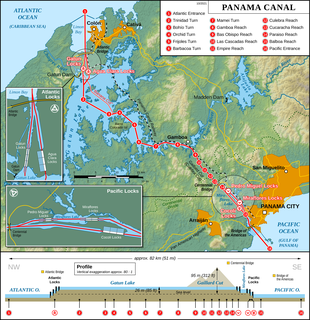
WThe Panama Canal is an artificial 82 km (51 mi) waterway in Panama that connects the Atlantic Ocean with the Pacific Ocean. The canal cuts across the Isthmus of Panama and is a conduit for maritime trade. One of the largest and most difficult engineering projects ever undertaken, the Panama Canal shortcut greatly reduces the time for ships to travel between the Atlantic and Pacific oceans, enabling them to avoid the lengthy, hazardous Cape Horn route around the southernmost tip of South America via the Drake Passage or Strait of Magellan and the even less popular route through the Arctic Archipelago and the Bering Strait.
 W
WThe Rhine–Main–Danube Canal, in Bavaria, Germany, connects the Main and the Danube rivers across the European Watershed, running from Bamberg via Nuremberg to Kelheim. The canal connects the North Sea and Atlantic Ocean to the Black Sea, providing a navigable artery between the Rhine delta, and the Danube Delta in south-eastern Romania and south-western Ukraine. The present canal was completed in 1992 and is 171 kilometres (106 mi) long.
 W
WThe Sabine–Neches Waterway is located in southeast Texas and Calcasieu Parish, Louisiana, United States. The waterway includes parts of the Neches River, Sabine River, Sabine Lake, and Taylor Bayou. The waterway ranks as third-busiest waterway in the U.S. in terms of cargo tonnage, according to the American Association of Port Authorities. It also ranks as the top bulk liquid cargo waterway, the top U.S. crude-oil importer, and is projected to become the largest LNG exporter in the United States. The Gulf Intracoastal Waterway crosses the waterway near Port Arthur.
 W
WThe Saint Lawrence Seaway is a system of locks, canals, and channels in Canada and the United States that permits oceangoing vessels to travel from the Atlantic Ocean to the Great Lakes of North America, as far inland as Duluth, Minnesota, at the western end of Lake Superior. The seaway is named for the Saint Lawrence River, which flows from Lake Ontario to the Atlantic Ocean. Legally, the seaway extends from Montreal, Quebec, to Lake Erie, and includes the Welland Canal.
 W
WThe St. Peters Canal is a small shipping canal located in eastern Canada on Cape Breton Island. It crosses an isthmus in the village of St. Peter's, Nova Scotia which connects St. Peters Inlet of Bras d'Or Lake to the north with St. Peters Bay of the Atlantic Ocean to the south.
 W
WThe Sault Ste. Marie Canal is a National Historic Site in Sault Ste. Marie, Ontario, and is part of the national park system, managed by Parks Canada. It includes a lock to bypass the rapids on the St. Marys River.
 W
WSethusamudram Shipping Canal Project is a proposed project to create a shipping route in the shallow straits between India and Sri Lanka. This would provide a continuously navigable sea route around the Indian Peninsula. The channel would be dredged in the Sethusamudram sea between Tamil Nadu and Sri Lanka, passing through the limestone shoals of Rama's Bridge.
 W
WThe Soo Locks are a set of parallel locks, operated and maintained by the United States Army Corps of Engineers, Detroit District, which enable ships to travel between Lake Superior and the lower Great Lakes. They are located on the St. Marys River between Lake Superior and Lake Huron, between the Upper Peninsula of the US state of Michigan and the Canadian province of Ontario. They bypass the rapids of the river, where the water falls 21 feet (6.4 m). The locks pass an average of 10,000 ships per year, despite being closed during the winter from January through March, when ice shuts down shipping on the Great Lakes. The winter closure period is used to inspect and maintain the locks.
 W
WThe Soulanges Canal is an abandoned shipping canal in Quebec, Canada. It follows the north shore of the Saint Lawrence River between Pointe-des-Cascades and Coteaux-Landing, bypassing the rapids between Lake Saint-Louis and Lake Saint-Francis. In between, it passes through the towns of Les Cèdres and Coteau-du-Lac. It superseded the first Beauharnois Canal which was on the south shore of the Saint Lawrence. It is 23 kilometers (14 mi) long and had a 4.3-meter (14.1 ft) draught. Five locks measuring 85.3 m × 14 m give a total rise of 25 meters (82 ft).
 W
WThe Sturgeon Bay Ship Canal is a shipping canal connecting Sturgeon Bay on Green Bay with Lake Michigan, across the Door Peninsula, at the city of Sturgeon Bay, Wisconsin, United States. The canal allows shipping to transit directly from Lake Michigan to Green Bay, avoiding the dangerous Porte des Morts strait. The canal is approximately 1.3 miles in length, dug through the eastern side of the Door Peninsula in a northwest to southeast orientation. At its northwestern end, it connects to a dredged channel in Sturgeon Bay which in turn leads to Green Bay. The canal was dug by a private group headed by then-president of Chicago and North Western Railway, William B. Ogden, between July 8, 1872 and the late fall of 1881. Although smaller craft began using the canal in 1880, it was not open for large-scale watercraft until 1890.
 W
WThe Suez Canal is an artificial sea-level waterway in Egypt, connecting the Mediterranean Sea to the Red Sea through the Isthmus of Suez. It is often considered to define the border between Africa and Asia. Constructed by the Suez Canal Company between 1859 and 1869, it officially opened on 17 November that year. The canal offers watercraft a more direct route between the North Atlantic and northern Indian oceans via the Mediterranean and Red seas, thus avoiding the South Atlantic and southern Indian oceans and reducing the journey distance from the Arabian Sea to London, for example, by approximately 8,900 kilometres (5,500 mi). It extends from the northern terminus of Port Said to the southern terminus of Port Tewfik at the city of Suez. Its length is 193.30 km (120.11 mi) including its northern and southern access-channels. In 2012, 17,225 vessels traversed the canal.
 W
WThe Tay Canal is the portion of the Tay River in the eastern Ontario region, providing a connection between the town of Perth and the Rideau Canal at Beveridge Bay on Lower Rideau Lake. The canal is 9.8 km (6.1 mi) in length and is operated today by Parks Canada as part of their Rideau Canal operations. At the entrance to the Tay Canal are two locks, Upper and Lower Beveridges which provide a total lift of 7.6 m (25 ft.)
 W
WThe Thun ship canal is a 500-metre (1,600 ft) long canal in the Swiss canton of Bern. Together with a navigable reach of the Aare of similar length, it connects Lake Thun with a quay in the town of Thun adjacent to Thun railway station.
 W
WThe Trent–Severn Waterway is a 386-kilometre-long canal route connecting Lake Ontario at Trenton to Georgian Bay, Lake Huron, at Port Severn. Its major natural waterways include the Trent River, Otonabee River, Kawartha Lakes, Lake Simcoe, Lake Couchiching and Severn River. Its scenic, meandering route has been called "one of the finest interconnected systems of navigation in the world".
 W
WThe Vĩnh Tế Canal is an 87-kilometre-long (54 mi) canal in southern Vietnam, designed to give the territory of Châu Đốc a direct access to the Hà Tiên sea gate, Gulf of Siam.
 W
WLenin Volga–Don Shipping Canal is a broad ship canal that connects the Volga and the Don at their closest points. Opened in 1952, its length is 101 km (63 mi), 45 km (28 mi) of which is through rivers and reservoirs.
 W
WThe Wabash and Erie Canal was a shipping canal that linked the Great Lakes to the Ohio River via an artificial waterway. The canal provided traders with access from the Great Lakes all the way to the Gulf of Mexico. Over 460 miles long, it was the longest canal ever built in North America.
 W
WThe Welland Canal is a ship canal in Ontario, Canada, connecting Lake Ontario and Lake Erie. It forms a key section of the St. Lawrence Seaway and Great Lakes Waterway. Traversing the Niagara Peninsula from Port Weller in St. Catharines to Port Colborne, it enables ships to ascend and descend the Niagara Escarpment and bypass Niagara Falls. The name currently refers to the fourth such canal, three earlier and much smaller canals servicing the same route are also known as the Welland.
 W
WThe White Sea–Baltic Canal, often abbreviated to White Sea Canal is a ship canal in Russia opened on Wednesday 2 August 1933. It connects the White Sea, in the Arctic Ocean, with Lake Onega, which is further connected to the Baltic Sea. Until 1961, its original name was the Stalin White Sea–Baltic Canal.
 W
WThe Wiener Neustadt Canal was Austria's only shipping canal, originally meant to reach to Trieste. It became operational in 1803 and ceased to be used for transportation before World War I.
 W
WThe Xerxes Canal was a navigable canal through the base of the Mount Athos peninsula in Chalkidiki, northern Greece, built by king Xerxes I of Persia in the 5th century BCE. It is one of the few monuments left by the Persian Empire in Europe.