 W
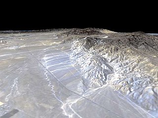
WThe Tehachapi Mountains are a mountain range in the Transverse Ranges system of California in the Western United States. The range extends for approximately 40 miles (64 km) in southern Kern County and northwestern Los Angeles County.
 W
WAllium howellii is a North American species of wild onion known by the common name Howell's onion. It is endemic to California.
 W
WClarkia exilis is a small herbaceous annual plant of western North America. It is an uncommon species in the evening primrose family known by the common names Kern River clarkia and slender clarkia.
 W
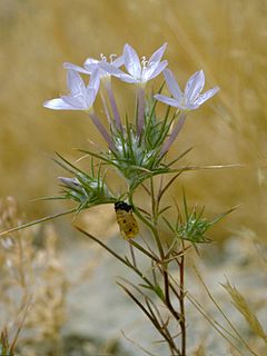
WDiplacus pictus is a species of monkeyflower known by the common name calico monkeyflower.
 W
WEriastrum pluriflorum is a species of flowering plant in the phlox family known by the common names Tehachapi woollystar and many-flowered eriastrum.
 W
WEriogonum callistum is a rare species of wild buckwheat, known by the common name Tehachapi buckwheat.
 W
WFritillaria striata, known by the common name striped adobe lily, is an uncommon species of fritillary.
 W
WHolocarpha heermannii is a species of flowering plant in the aster family known by the common name Heermann's tarweed. It is endemic to California.
 W
WPhacelia nashiana is a species of phacelia known by the common name Charlotte's phacelia. It is endemic to California, where it is known only from the ecotone where the lower Sierra Nevada and Tehachapi Mountains transition into the Mojave Desert. It grows in scrub and woodland and on granite mountain slopes.
 W
WAlta Wind Energy Center (AWEC), also known as Mojave Wind Farm, is the third largest onshore wind energy project in the world. The Alta Wind Energy Center is a wind farm located in Tehachapi Pass of the Tehachapi Mountains, in Kern County, California. As of 2013, it is the largest wind farm in the United States, with a combined installed capacity of 1,550 MW (2,080,000 hp). The project, being developed near Tehachapi Pass Wind Farm— site of the first large-scale wind farms installed in the U.S. in the 1970s and 1980s—is "a powerful illustration of the growing size and scope of modern wind projects".
 W
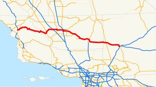
WState Route 58 is a major east-west state highway in the U.S. state of California that runs across the Coast Ranges, the southern San Joaquin Valley, the Tehachapi Mountains, which border the southern Sierra Nevada, and the Mojave Desert. It runs between U.S. Route 101 near Santa Margarita and Interstate 15 in Barstow. It has junctions with Interstate 5 near Buttonwillow, State Route 99 in Bakersfield, State Route 202 in Tehachapi, State Route 14 near Mojave, and U.S. Route 395 at Kramer Junction. SR 58 also provides access to Edwards Air Force Base. At various points it is known as the Calf Canyon Highway, Carrisa Highway, Bakersfield-McKittrick Highway, Rosa Parks Highway, Rosedale Highway, Barstow-Bakersfield Highway, Kern County Korean War Veterans Memorial Highway, and Mojave-Barstow Highway.
 W
WBear Mountain is a peak in the Tehachapi Mountains, near Tehachapi, California.
 W
WBear Valley Springs is a guarded-gate community in Kern County, California, United States. Bear Valley Springs is in the Tehachapi Mountains and is part of the greater Tehachapi area. The elevation ranges from 4,121 feet (1,256 m) to 6,934 feet (2,113 m). The population fluctuates between a low during the winter months when snow is common, to a high in the summer months when its elevation keeps it much cooler than surrounding areas and major cities. The population was 5,172 at the 2010 census, up from 4,232 at the 2000 census. For statistical purposes, the United States Census Bureau has defined Bear Valley Springs as a census-designated place (CDP). The census definition of the area may not precisely correspond to local understanding of the area with the same name.
WState Route 58 is a major east-west state highway in the U.S. state of California that runs across the Coast Ranges, the southern San Joaquin Valley, the Tehachapi Mountains, which border the southern Sierra Nevada, and the Mojave Desert. It runs between U.S. Route 101 near Santa Margarita and Interstate 15 in Barstow. It has junctions with Interstate 5 near Buttonwillow, State Route 99 in Bakersfield, State Route 202 in Tehachapi, State Route 14 near Mojave, and U.S. Route 395 at Kramer Junction. SR 58 also provides access to Edwards Air Force Base. At various points it is known as the Calf Canyon Highway, Carrisa Highway, Bakersfield-McKittrick Highway, Rosa Parks Highway, Rosedale Highway, Barstow-Bakersfield Highway, Kern County Korean War Veterans Memorial Highway, and Mojave-Barstow Highway.
 W
WCalifornia's 16th State Senate district is one of 40 California State Senate districts. It is currently represented by Republican Shannon Grove of Bakersfield.
 W
WCalifornia's 23rd congressional district is a congressional district in the U.S. state of California.
 W
WCalifornia's 34th State Assembly district is one of 80 California State Assembly districts. It is currently represented by Republican Vince Fong of Bakersfield.
 W
WCameron is an unincorporated community in the Tehachapi Mountains, in Kern County, California. It is located on the Union Pacific Railroad 9 miles (14 km) east-southeast of Tehachapi, at an elevation of 3,802 feet (1,159 m).
 W
WComanche Point is the northwestern headland and prominence of the Tejon Hills, notably extending westward into the southern San Joaquin Valley, west of the Tehachapi Mountains. It is approximately 4 miles (6.4 km) south of Arvin, in Kern County, California.
WCummings Mountain is a mountain located in the Tehachapi Mountains of central California.
WDouble Mountain is the highest point in the Tehachapi Mountains of California. It has two summits of nearly the same elevation. It is south of the town of Tehachapi, Highway 58 and Tehachapi Pass. Due to its elevation, the mountain receives snowfall during the winter.
 W
WThe Errea House is a historic house located at 311 S. Green St. in Tehachapi, California. The house is the only surviving building from the settlement of Tehichipa, the first town in the Tehachapi area. Tehichipa was founded in 1869, and the house was built sometime between 1870 and 1875. In 1876, the Southern Pacific Railroad bypassed Tehichipa, instead establishing a new townsite at Tehachapi Summit, which later became Tehachapi. The railroad led to the decline of Tehichipa's shipping industry, and the town's residents gradually moved to Tehachapi. The Errea House was moved to Tehachapi as well around 1900. No buildings from the original settlement survive at the site of Tehichipa, and the Errea House is the only building remaining from the town. The Errea House is now located across from the Tehachapi Museum, where it helps illustrate the city's early history.
 W
WFort Tejon in California is a former United States Army outpost which was intermittently active from June 24, 1854, until September 11, 1864. It is located in the Grapevine Canyon between the San Emigdio Mountains and Tehachapi Mountains. It is in the area of Tejon Pass along Interstate 5 in Kern County, California, the main route through the mountain ranges separating the Central Valley from the Los Angeles Basin and Southern California. The fort's location protected the San Joaquin Valley from the south and west.
WThe 1857 Fort Tejon earthquake occurred at about 8:20 a.m. on January 9 in central and Southern California. One of the largest recorded earthquakes in the United States, with an estimated moment magnitude of 7.9, it ruptured the southern part of the San Andreas Fault for a length of about 225 miles, between Parkfield and Wrightwood.
 W
WThe Garlock Fault is a left-lateral strike-slip fault running northeast–southwest along the north margins of the Mojave Desert of Southern California, for much of its length along the southern base of the Tehachapi Mountains.
WGolden Hills is a census-designated place (CDP) in the Tehachapi Mountains, in Kern County, California, United States. The population was 8,656 at the 2010 census, up from 7,434 at the 2000 census. Golden Hills adjoins the city of Tehachapi on the west.
 W
WGorman is an unincorporated community in northwestern Los Angeles County. It is located in Peace Valley south of the Tejon Pass, which links Southern California with the San Joaquin Valley and Northern California. Due to this location, the area has served as a historic travel stop dating back to the indigenous peoples of California. Tens of thousands of motorists travel through Gorman daily on the Golden State Freeway since the highway's completion in the mid-20th Century.
 W
WGrapevine is an unincorporated community in Kern County, California, at the southern end of the San Joaquin Valley. The small village is directly adjacent to Interstate 5 and consists mainly of travelers' and roadside services. At an elevation of 1,499 feet (457 m), the community is located at the foot of a grade known as The Grapevine that starts at the mouth of Grapevine Canyon, immediately south of the community, and ascends the canyon to the Tejon Pass, which separates the Tehachapi Mountains from the San Emigdio Mountains via Interstate 5.
 W
WThe Courtlandt Gross House is a historic house located at 18600 Courtlandt Court in Tehachapi, Kern County, California.
 W
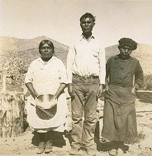
WThe Kawaiisu are a Native Californian ethnic group in the United States, which lives in the Tehachapi Valley and across the Tehachapi Pass in the southern Sierra Nevada Mountains to the north, toward Lake Isabella and Walker Pass. Historically, the Kawaiisu also traveled eastward on food-gathering trips to areas in the northern Mojave Desert, to the north and northeast of the Antelope Valley, Searles Valley, as far east as the Panamint Valley, the Panamint Mountains, and the western edge of Death Valley. Today, some Kawaiisu people are enrolled in the Tule River Indian Tribe.
 W
WKeene is a census-designated place (CDP) in Kern County, California in the foothills of the Tehachapi Mountains at the southern extreme of the San Joaquin Valley. Keene is located 8.5 miles (14 km) northwest of Tehachapi, at an elevation of 2,602 feet (793 m). The population was 431 at the 2010 census, up from 339 at the 2000 census.
WThe 1952 Kern County earthquake occurred on July 21 in the southern San Joaquin Valley and measured 7.3 on the moment magnitude scale. The main shock occurred at 4:52 am Pacific Daylight Time, killed 12 people and injured hundreds, and caused an estimated $60 million in property damage. A small sector of damage near Bealville corresponded to a maximum Mercalli intensity of XI (Extreme), though this intensity rating was not representative of the majority of damage. The earthquake occurred on the White Wolf Fault near the community of Wheeler Ridge and was the strongest to occur in California since the 1906 San Francisco earthquake.
 W
WLebec is an unincorporated area and census-designated place in southwestern Kern County, California. As of the 2010 census, the population was 1,468.
 W
WMountain Valley Airport is a privately owned public-use airport located two nautical miles southeast of the central business district of Tehachapi, in Kern County, California, United States.
 W
WTehachapi Municipal Airport is in Tehachapi, Kern County, California. It covers 264 acres (107 ha) and has one runway.
 W
WThe Tehachapi Renewable Transmission Project is a project involving the construction of approximately 173 miles of new and upgraded high-voltage transmission lines for transmission of electricity from wind farms and other generating units in southeastern Kern County, California to Los Angeles County and San Bernardino County.
 W
WThe Serrano are an indigenous people of California. They use the autonyms of Taaqtam, meaning "people"; Maarrênga’yam, "people from Morongo"; and Yuhaviatam, "people of the pines." Today the Maarrênga'yam are enrolled in the Morongo Band of Mission Indians, and the Yuhaviatam are enrolled in the San Manuel Band of Mission Indians. Additionally, some Serrano people are enrolled in the Soboba Band of Luiseno Indians.
 W
WStallion Springs is a census-designated place (CDP) in the Tehachapi Mountains, in Kern County, California, USA. The population was 2,488 at the 2010 census, up from 1,522 at the 2000 census. Stallion Springs is located in the greater Tehachapi Area.
 W
WThe Tehachapi Loop is a 3,779 feet long spiral, or helix, on the Union Pacific Railroad Mojave Subdivision through Tehachapi Pass, of the Tehachapi Mountains in Kern County, south-central California. The line connects Bakersfield and the San Joaquin Valley to Mojave in the Mojave Desert.
 W
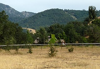
WTehachapi Pass is a mountain pass crossing the Tehachapi Mountains in Kern County, California. Traditionally, the pass marks the northeast end of the Tehachapis and the south end of the Sierra Nevada range.
 W
WThe Tehachapi Pass wind farm is one of the first large-scale wind farms installed in the U.S., with around 710 megawatts (950,000 hp) produced by about 3400 wind turbines.
 W
WThe Tehachapi Railroad Depot was a railroad station in Tehachapi, California. The depot was built in 1904 along a Southern Pacific Railroad line built in 1876; the railroad founded the town of Tehachapi and drew the residents of nearby Tehichipa to the new settlement. The depot served a significant section of railroad, as it was located near the Tehachapi Loop and was one of the most active rural stations during World War II. The station later served as a warehouse and a railroad office.
 W
WThe Tehachapi Wind Resource Area (TWRA) is a large wind resource area along the foothills of the Sierra Nevada and Tehachapi Mountains in California. It is the largest wind resource area in California, encompassing an area of approximately 800 sq mi (2,100 km2) and producing a combined 3,507 MW of renewable electricity between its 5 independent wind farms.
 W
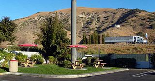
WTehachapi is a city in Kern County, California, in the Tehachapi Mountains, at an elevation of 3,970 feet (1,210 m) between the San Joaquin Valley and the Mojave Desert.
WThe Tejon Hills are a low mountain range in the Transverse Ranges, in southern Kern County, California. The highest point of the hills is Comanche Mountain, at 364 feet (111 m) in elevation.
 W
WThe Tejon Pass, previously known as Portezuelo de Cortes, Portezuela de Castac, and Fort Tejon Pass, is a mountain pass between the southwest end of the Tehachapi Mountains and northeastern San Emigdio Mountains, linking Southern California north to the Central Valley. It has been traversed by major roads such as the El Camino Viejo, the Stockton – Los Angeles Road, the Ridge Route, U.S. Route 99, and now Interstate 5.
WThe Old Tejon Pass is a mountain pass in the Tehachapi Mountains linking Southern and Central California.
 W
WTejon Ranch Company, based in Lebec, California, is one of the largest private landowners in California. The company was incorporated in 1936 to organize the ownership of a large tract of land that was consolidated from four Mexican land grants acquired in the 1850s and 1860s by ranch founder General Edward Fitzgerald Beale.
 W
WThe White Wolf Fault is a fault in southern California, located along the northwestern transition of the Tejon Hills and Tehachapi Mountains with the San Joaquin Valley. It is north of the intersection of the San Andreas Fault and the Garlock Fault, and roughly parallel with the latter. It is classed as a reverse fault with a left lateral (sinistral) component.