 W
WThe Åland Islands dispute was one of the first issues put up for arbitration by the League of Nations on its formation. The Åland Islands' population's demand for self-determination was not met and sovereignty over the islands was retained by Finland, but international guarantees were given to allow the population to pursue its own culture, relieving the threat of forced assimilation by Finnish culture as perceived by the islanders.
 W
WAtafu, formerly known as the Duke of York Group, is a group of 52 coral islets within Tokelau in the south Pacific Ocean, 500 kilometres north of Samoa. Covering 2.5 square kilometres, it is the smallest of the three islands that constitute Tokelau, and is composed of an atoll surrounding a central lagoon, which itself covers some 15 km2 (5.8 sq mi). The atoll lies some 800 kilometres south of the equator at 8° 35' South, 172° 30' West.
 W
WBirnie Island is a small, uninhabited coral island, 20 hectares in area, part of the Phoenix Island group, that is part of the Republic of Kiribati. It is located about 100 km SE of Kanton Island and 90 km WNW of Rawaki Island, formerly known as Phoenix Island. It lies at 03°35′S 171°33′W. Birnie island measures only 1.2 km long and 0.5 km wide. There is no anchorage, but landing can be made on the lee beach.
 W
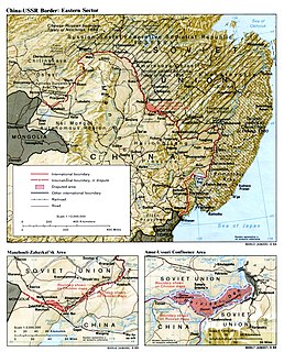
WBolshoi Ussuriysky Island, or Heixiazi Island, is a sedimentary island at the confluence of the Ussuri and Amur rivers. It is divided between the People's Republic of China (PRC) and Russia. It has an area of about 327 to 350 km2 and is bounded closely by Yinlong Island, and over ninety islets. Its position at the confluence of the Amur and the Ussuri and right next to the major Russian city of Khabarovsk, has given it great strategic importance.
 W
WThe Canton and Enderbury Islands consist of the coral atolls of Canton and Enderbury in the northeastern part of the Phoenix Islands, about 1,850 miles (3,000 km) south of Hawaii in the central Pacific Ocean. The islands were vital naval and air bases on the route between the Americas and the Philippines and Australia and were claimed by both the United Kingdom and the United States. From 1939 to 1979, they formed an Anglo–American condominium, with administration jointly exercised by the U.S. and the UK. This arrangement only covered Canton and Enderbury islands; the remaining Phoenix Islands were still claimed by the U.S. under the Guano Islands Act, but aside from Hull Island were either abandoned or remained under exclusive British control until 1979.
 W
WCaroline Island, is the easternmost of the uninhabited coral atolls which comprise the southern Line Islands in the central Pacific Ocean of Kiribati.
 W
WClipperton Island is an uninhabited 6 km2 (2.3 sq mi) coral atoll in the eastern Pacific Ocean off the coast of Central America. It is 10,677 km (6,634 mi) from Paris, France, 5,400 km (2,900 nmi) from Papeete, Tahiti, and 1,080 km (580 nmi) from Mexico. It is an overseas state private property of France, under direct authority of the Minister of Overseas France.
 W
WDetroit Island is a mostly privately owned island in Lake Michigan in the southern part of the town of Washington in Door County, Wisconsin, United States. The island has a land area of 2.578 km². The northern end of the island borders the waters of Detroit Harbor.
 W
WEnderbury Island, also known as Ederbury Island or Guano Island, is a small, uninhabited atoll 63 km ESE of Kanton Island in the Pacific Ocean at 3°08′S 171°05′W. It is about 1 mile (1.6 km) wide and 3 miles (4.8 km) long, with a reef stretching out 60–200 metres. Forming a part of the Canton and Enderbury Islands condominium from 1939 to 1979, the island is now a possession of the Republic of Kiribati.
 W
WFakaofo, formerly known as Bowditch Island, is a South Pacific Ocean atoll located in the Tokelau Group. The actual land area is only about 3 km², consisting of islets on a coral reef surrounding a central lagoon of some 45 km². According to the 2006 census 483 people officially live on Fakaofo. Of those present 70% belong to the Congregational Church and 22% to the Catholic Church.
 W
WFlanagan Island is an island located within the Virgin Islands archipelago in the Caribbean and forms part of the U.S. Virgin Islands.
WFlint Island is an uninhabited coral island in the central Pacific Ocean, part of the Southern Line Islands under the jurisdiction of Kiribati. In 2014 the Kiribati government established a twelve-nautical-mile exclusion zone around each of the southern Line Islands.
 W
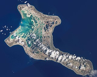
WFunafuti is an atoll and the capital of the island nation of Tuvalu. It has a population of 6,320 people, making it the country's most populated atoll, with 60.15 percent of Tuvalu's population. It is a narrow sweep of land between 20 and 400 metres wide, encircling a large lagoon 18 km long and 14 km wide. The average depth in the Funafuti lagoon is about 20 fathoms. With a surface of 275 square kilometres (106.2 sq mi), it is by far the largest lagoon in Tuvalu. The land area of the 33 islets aggregates to 2.4 square kilometres (0.9 sq mi), less than one percent of the total area of the atoll. Cargo ships can enter Funafuti's lagoon and dock at the port facilities on Fongafale.
 W
WThe Îles du Connétable are two islands within French Guiana that were claimed under the Guano Islands Act of 1856 for the United States of America.
 W
WIsla de la Juventud is the second-largest Cuban island and the seventh-largest island in the West Indies. The island was called the Isle of Pines until 1978. It has an area 2,200 km2 (850 sq mi) and is 50 km (31 mi) south of the island of Cuba, across the Gulf of Batabanó. The island lies almost directly south of Havana and Pinar del Río and is a Special Municipality, not part of any province and is therefore administered directly by the central government of Cuba. The island has only one municipality, also named Isla de la Juventud.
 W
WThe Island of Palmas Case was a territorial dispute over the Island of Palmas between the Netherlands and the United States which was heard by the Permanent Court of Arbitration. Palmas was declared to be a part of the Netherlands East Indies and is now part of Indonesia.
 W
WKanton Island, previously known as "Mary Island", "Mary Balcout's Island" or "Swallow Island", is the largest, northernmost, and as of 2020, the sole inhabited island of the Phoenix Islands, in the Republic of Kiribati. It is an atoll located in the South Pacific Ocean roughly halfway between Hawaii and Fiji at 2°50′S 171°40′W. The island is a narrow ribbon of land around a lagoon; an area of 40 square kilometers. Kanton's closest neighbor is the uninhabited island of Enderbury, 63 km to the south. The capital of Kiribati, South Tarawa, lies 1,765 km to the west. As of 2005, the population was 41, down from 61 in 2000. In May 2010 the population was reportedly 24, with 14 adults and 10 children. The island's sole village is called Tebaronga.
 W
WKiritimati or Christmas Island is a Pacific Ocean coral atoll in the northern Line Islands. It is part of the Republic of Kiribati. Its Gilbertese name is the rendition of the English word "Christmas" according to its phonology, in which the combination ti is pronounced s, and the name is thus pronounced.
 W
WLigitan is a small island in Tawau, Sabah, located east of the island of Borneo, in the Celebes Sea. In the past, the island was at the centre of a territorial dispute between Malaysia and Indonesia. The matter was brought for adjudication before the International Court of Justice and, at the end of 2002, the Court awarded the island along with the island of Sipadan to Malaysia, on the basis of the "effective occupation" displayed by the latter's predecessor and the absence of any other superior title. The Philippines had applied to intervene in the proceedings on the basis of its claim to Northern Borneo, but its request was turned down by the Court early in 2001.
WMalden Island, sometimes called Independence Island in the nineteenth century, is a low, arid, uninhabited atoll in the central Pacific Ocean, about 39 km2 (15 sq mi) in area. It is one of the Line Islands belonging to the Republic of Kiribati. The lagoon is entirely enclosed by land, though it is connected to the sea by underground channels, and is quite salty.
 W
WManihiki is an island in the northern group of the Cook Islands known informally as the "Island of Pearls". It is approximately 1,299 kilometres (807 mi) north of the capital island of Rarotonga, making it one of the most remote inhabitations in the Pacific Ocean. Its name has two possible meanings: It's believed that the original name of the island was Manuhiki, inspired by the aboriginal discovers Manu coming from the word Rua Manu and Hiki meaning ashore, so the literal translation would be canoe carried ashore. The second interpretation is that the original discoverers were from Manihi, an island in Tuamotus, so the name of the island would mean Little Manihi.
 W
WManra or Sydney Island, is one of the Phoenix Islands in the Republic of Kiribati. It lies at 4°27′S 171°16′W. longitude, and has an area of 4.4 km2. and an elevation of approximately six meters. Together with the seven other Phoenix Islands, it forms part of the Phoenix Islands Protected Area,. Charles Darwin visited the island during his five-year voyage (1831-1836), following which in 1842 he published an explanation for the creation of coral atolls in the South Pacific.
 W
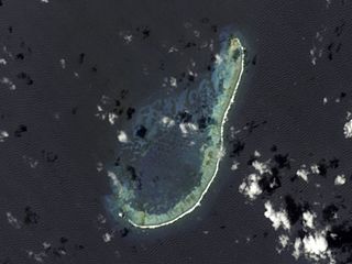
WMcKean Island is a small, uninhabited island in the Phoenix Islands, Republic of Kiribati. It is located at 3°36′S 174°07′W. Its area is 57 hectares.
 W
WMiangas or Palmas is North Sulawesi's northernmost island, and one of 92 officially listed outlying islands of Indonesia.
 W
WThe Middle Rocks are two uninhabited small rocks separated by 250 metres (820 ft) of open water at the eastern opening of the Strait of Singapore on the western edge of the South China Sea. The islands were disputed territory between Malaysia and Singapore until, on 23 May 2008, the International Court of Justice decided that sovereignty over Middle Rocks belonged to Malaysia by 15 votes to one.
 W
WMinami-Tori-shima , also known as Marcus Island, is an isolated Japanese coral atoll in the northwestern Pacific Ocean, located some 1,848 kilometers (1,148 mi) southeast of Tokyo and 1,267 km (787 mi) east of the closest Japanese island, South Iwo Jima of the Ogasawara Islands, and nearly on a straight line between mainland Tokyo and Wake Island, 1,415 km (879 mi) further to the east-southeast. The closest island to Minami-Tori-shima is East Island in the Mariana Islands, which is 1,015 km (631 mi) to the west-southwest.
 W
WNikumaroro, formerly known as Kemins Island or Gardner Island, is part of the Phoenix Islands, Kiribati, in the western Pacific Ocean. It is a remote, elongated, triangular coral atoll with profuse vegetation and a large central marine lagoon. Nikumaroro is about 7.5 km (4.7 mi) long by 2.5 km (1.6 mi) wide. The rim has two narrow entrances, both of which are blocked by a wide reef, which is dry at low tide. The ocean beyond the reef is very deep, and the only anchorage is at the island's west end, across the reef from the ruins of a mid-20th-century British colonial village, but this is safe only with the southeast trade winds. Landing has always been difficult and is most often done south of the anchorage. Although occupied at various times during the past, the island is uninhabited today.
 W
WNiulakita is the southernmost island of Tuvalu, and also the name of the only village on this island. Niulakita has a population of 34. The residents of Niulakita have moved to the island from Niutao. Niulakita is represented in the Parliament of Tuvalu by the members of the constituency of Niutao.
 W
WNukufetau is an atoll that is part of the nation of Tuvalu. The atoll was claimed by the US under the Guano Islands Act some time in the 19th century and was ceded in a treaty of friendship concluded in 1979 and coming into force in 1983. It has a population of 597 who live on Savave islet. In 1951 the school that was located on Motumua islet was transferred to Savave and became the government primary school for Nukufetau. It was named the Tutasi Memorial School in honour of its predecessor.
 W
WNukulaelae is an atoll that is part of the nation of Tuvalu, and it has a population of 300. The largest settlement is Pepesala on Fangaua islet with a population of 300 people. It has the form of an oval and consists of at least 15 islets. The inhabited islet is Fangaua, which is 1.5 kilometres (0.93 mi) long and 50 to 200 metres wide. The easternmost point of Tuvalu is Niuoko islet. The Nukulaelae Conservation Area covers the eastern end of the lagoon. A baseline survey of marine life in the conservation zone was conducted in 2010.
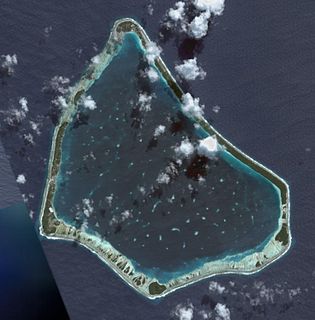
WNukunonu is the largest atoll within Tokelau, a dependency of New Zealand, in the south Pacific Ocean. It comprises 30 islets surrounding a central lagoon, with about 5.5 km2 (2.1 sq mi) of land area and a lagoon surface area of 109 km2 (42 sq mi). Motuhaga is the only islet that has inhabitants. The estimated population is 80-120.
 W
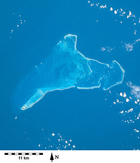
WOrona atoll, also known as Hull Island, is one of the Phoenix Islands in the Republic of Kiribati. It measures approximately 8.8 km (5 mi) by 4 km (2 mi), and like Kanton, is a narrow ribbon of land surrounding a sizable lagoon with depths of 15–20 metres (49–66 ft). Numerous passages connect the lagoon to the surrounding ocean, only a couple of which will admit even a small boat. Total land area is 3.9 km2 (2 sq mi), and the maximum elevation is nine metres.
 W
WPedra Branca is an outlying island and also the easternmost point of Singapore. The name means "white rock" in Portuguese, and refers to whitish guano deposited on the rock. The island consists of a small outcrop of granite rocks with an area of about 8,560 square metres (92,100 sq ft). During the low water spring tide it measures, at its longest, 137 metres (449 ft) and has an average width of 60 metres (200 ft). Pedra Branca is situated at 1°19′48″N 104°24′27″E, where the Singapore Strait meets the South China Sea.
 W
WPenrhyn is an island in the northern group of the Cook Islands in the south Pacific Ocean. The northernmost island in the group, it is located at 1,365 km (848 mi) north-north-east of the capital island of Rarotonga, 9 degrees south of the equator. Its nearest neighbours are Rakahanga, and Manihiki, approximately 350 kilometres (220 mi) to the southwest. Once one of the most heavily populated atolls, it was almost completely depopulated by Peruvian slavers in 1864.
 W
WPicton, Lennox and Nueva form a group of three islands at the extreme southern tip of South America, in the Chilean commune of Cabo de Hornos in Antártica Chilena Province, Magallanes and Antártica Chilena Region. Located in the Tierra del Fuego archipelago, they lie east of Navarino Island and are separated from the Argentine part of Isla Grande in the north by the Beagle Channel. They have an area of 170.4 km2 (Lennox), 105.4 km2 (Picton), 120.0 km2 (Nueva).
 W
WPlum Island is an island in Lake Michigan in the southern part of the town of Washington in Door County, off the tip of the Door Peninsula in the U.S. state of Wisconsin. The uninhabited island has a land area of 1.179 square kilometres (0.455 sq mi) or 117.87 hectares. The island is a bird sanctuary under control of the United States Fish and Wildlife Service and part of the Green Bay National Wildlife Refuge. The island also holds the unmanned Plum Island Range Lights. There are an estimated 250 shipwrecks off the island's shores.
 W
WPukapuka, formerly Danger Island, is a coral atoll in the northern group of the Cook Islands in the Pacific Ocean. It is one of most remote islands of the Cook Islands, situated about 1,140 kilometres northwest of Rarotonga. On this small island, an ancient culture and distinct language has been maintained over many centuries. The traditional name for the atoll is Te Ulu-o-Te-Watu, and the northern islet where the people normally reside is affectionately known as Wale ('Home').
 W
WQuita Sueño Bank is a reef formation of Colombia which was once claimed by the United States, located 110 km north-northeast of Providencia Island.
 W
WRakahanga is part of the Cook Islands, situated in the central-southern Pacific Ocean. The unspoilt atoll is 1,248 kilometres from the Cook Islands' capital, Rarotonga, and lies 1,111 kilometres south of the equator. Its nearest neighbour is Manihiki which is just 44 kilometres away. Rakahanga's area is 4 square kilometres (1.5 sq mi). Its highest point is approximately 5 metres above sea level. The population was 83 in the 2016 Census of Population & Dwellings. Since 2014 Rakahanga's power has been 100% solar generated. The Rakahanga-Manihiki language differs from Cook Islands Maori.
 W
WRawaki is one of the Phoenix Islands in the Republic of Kiribati, also known by its previous name of Phoenix Island. It is a small, uninhabited atoll, approximately 1.2 by 0.8 kilometres in size and 65 hectares in area, with a shallow, brackish lagoon that is not connected to the open sea. It is located at 3.721°S 170.712°W.
 W
WRock Island is a wooded island off the tip of Wisconsin's Door Peninsula at the mouth of Green Bay, in Door County, Wisconsin. The 974.87-acre (394.5 ha) uninhabited island is almost entirely owned by the Wisconsin Department of Natural Resources, which maintains Rock Island State Park. It is the northernmost part of the town of Washington.
 W
WRoncador Bank is a mostly-submerged atoll with several sandy cays. It lies in the west Caribbean Sea off the coast of Central America.
 W
WRoncador Cay is a small island of the Roncador Bank, located in the west Caribbean Sea, off the coast of Central America, 150 kilometres east-northeast of Providencia Island.
 W
WThe Sangihe Islands – Indonesian: Kepulauan Sangihe – are a group of islands which constitute two regencies within the province of North Sulawesi, in northern Indonesia, the Sangihe Islands Regency and the Sitaro Islands Regency. They are located north-east of Sulawesi between the Celebes Sea and the Molucca Sea, roughly halfway between Sulawesi and Mindanao, in the Philippines; the Sangihes form the eastern limit of the Celebes Sea. The islands combine to total 813 square kilometers (314 sq mi), with many of the islands being actively volcanic with fertile soil and mountains.
 W
WSerrana Bank is an atoll in the western Caribbean Sea. It is a mostly underwater reef about 50 km long and 13 km wide and has six cays, or islets, the largest of which is Southwest Cay.
 W
WSipadan is the only oceanic island in Malaysia, rising 600 metres (2,000 ft) from the seabed. It is located in the Celebes Sea off the east coast of Sabah, Malaysia. It was formed by living corals growing on top of an extinct volcanic cone that took thousands of years to develop. Sipadan is located at the heart of the Indo-Pacific basin, the centre of one of the richest marine habitats in the world. More than 400 species of fish and hundreds of coral species have been classified in this ecosystem. Sipadan Island was at the top of Rodale's Scuba Diving Magazine Gold List for 'The Top Dive Destination in the World'. In fact it shared its top spot with 2 other destinations known for the diversity of their marine life — the Galápagos Islands and Truk in Micronesia.
WStarbuck Island is an uninhabited coral island in the central Pacific, and is part of the Central Line Islands of Kiribati. Former names include "Barren Island", "Coral Queen Island", "Hero Island", "Low Island", and "Starve Island".
 W
WThe Swan Islands, or Islas Santanilla or Islas del Cisne, initially named Islas de las Pozas by Christopher Columbus in 1502, is a chain of three islands located in the northwestern Caribbean Sea, approximately 153 kilometres (95 mi) off the coastline of Honduras, with a land area of 3.1 square kilometres.
 W
WVostok Island is an uninhabited coral island in the central Pacific Ocean, part of the Line Islands belonging to Kiribati. Other names for the island include Anne Island, Bostock Island, Leavitts Island, Reaper Island, Wostock Island or Wostok Island. The island was first sighted in 1820 by the Russian explorer Fabian Gottlieb von Bellingshausen, who named the island for his ship Vostok.
WWashington Island is an island of the state of Wisconsin situated in Lake Michigan. Lying about 7 miles (11 km) northeast of the tip of the Door Peninsula, it is part of Door County, Wisconsin. The island has a year-round population of 708 people according to the 2010 census. It has a land area of 60.89 km² and comprises over 92 percent of the land area of the town of Washington, as well as all of its population. The unincorporated community of Detroit Harbor is situated on the island. It is the largest in a group of islands that includes Plum, Detroit, Hog, Pilot, Fish, and Rock Islands. These islands form the Town of Washington. Detroit Harbor bay is on the south side of the island. A large part of Washington Island's economy is based on tourism.