 W
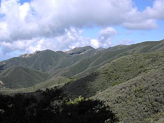
WThe Santa Ana Mountains are a short peninsular mountain range along the coast of Southern California in the United States. They extend for approximately 61 miles (98 km) southeast of the Los Angeles Basin largely along the border between Orange and Riverside counties.
 W
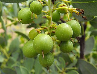
WArctostaphylos rainbowensis is a species of manzanita known by the common name Rainbow manzanita. It is endemic to California, where it is known only from northern San Diego and southern Riverside Counties in the Peninsular Ranges.
 W
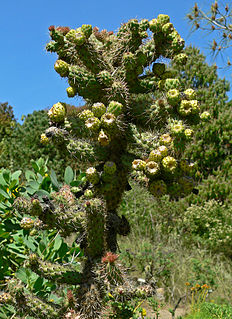
WCylindropuntia californica is a species of cactus known by the common names California cholla, snake cholla, and cane cholla.
 W
WCylindropuntia prolifera, known by the common name Coastal cholla, is a species of cactus.
 W
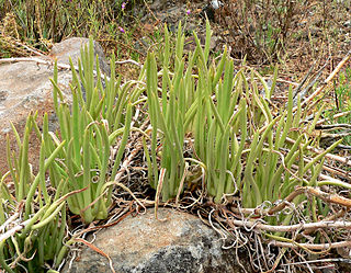
WDudleya edulis is a succulent plant known by the common name fingertips.
 W
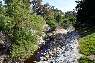
WAliso Creek is a 19.8-mile (31.9 km)-long, mostly urban stream in south Orange County, California. Originating in the Cleveland National Forest in the Santa Ana Mountains, it flows generally southwest and empties into the Pacific Ocean at Laguna Beach. The creek's watershed drains 34.9 square miles (90 km2), and it is joined by seven main tributaries. As of 2018, the watershed had a population of 144,000 divided among seven incorporated cities.
 W
WArroyo Trabuco is a 22-mile (35 km)-long stream in coastal southern California in the United States. Rising in a rugged canyon in the Santa Ana Mountains of Orange County, the creek flows west and southwest before emptying into San Juan Creek in the city of San Juan Capistrano. Arroyo Trabuco's watershed drains 54 square miles (140 km2) of hilly, semi-arid land and lies mostly in Orange County, with a small portion extending northward into Riverside County. The lower section of the creek flows through three incorporated cities and is moderately polluted by urban and agricultural runoff.
 W
WBell Canyon is a major drainage of the Santa Ana Mountains in Orange County, California in the United States. Bell Creek flows about 14.4 miles (23.2 km) in a southerly direction to its confluence with San Juan Creek. The Bell Canyon drainage is located to the east and parallel to Cañada Gobernadora, and to the south of Trabuco Creek. After Trabuco Creek, it is the second largest tributary of San Juan Creek in terms of length and its watershed area of 26 square miles (67 km2).
 W
WBlack Star Canyon is a remote mountain canyon in the Santa Ana Mountains, located in eastern Orange County, California. It is a watershed of the Santa Ana River. Black Star Canyon is a popular destination for mountain bikers as well as hikers due to its wild scenery.
 W
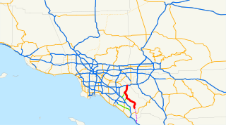
WState Route 241 is a state highway in the U.S. state of California that is a toll road for its entire length within Orange County in the Greater Los Angeles urban area. Its southern half from Ladera Ranch to near Irvine is the Foothill Transportation Corridor, while its northern half to the State Route 91 at the Anaheim–Yorba Linda line is part of the Eastern Transportation Corridor. State Route 241 connects with the other two highways of the Eastern Transportation Corridor, State Route 133 and State Route 261.
 W
WChaparral is a shrubland or heathland plant community found primarily in the U.S. state of California and in the northern portion of the Baja California Peninsula, Mexico. It is shaped by a Mediterranean climate and wildfire, featuring summer-drought-tolerant plants with hard sclerophyllous evergreen leaves, as contrasted with the associated soft-leaved, drought-deciduous, scrub community of coastal sage scrub, found below the chaparral biome. Chaparral covers 5% of the state of California, and associated Mediterranean shrubland an additional 3.5%. The name comes from the Spanish word for scrub oak, chaparro.
 W
WCleveland National Forest encompasses 460,000 acres, mostly of chaparral, with a few riparian areas. A warm dry mediterranean climate prevails over the forest. It is the southernmost U.S. National Forest of California. It is administered by the U.S. Forest Service, a government agency within the United States Department of Agriculture. It is divided into the Descanso, Palomar and Trabuco Ranger Districts and is located in the counties of San Diego, Riverside, and Orange.
 W
WCook's Corner is a Southern California bar built in 1884 that is popular with motorcyclists. It is located near Silverado in Trabuco Canyon, Orange County, California.
 W
WCristianitos Canyon Creek, a stream or arroyo, tributary to San Mateo Creek, in the Santa Ana Mountains. its source is within Orange County, California. Its source is at an altitude of 800 feet, at the head of Cristianitos Canyon, in the foothills of the Santa Ana Mountains, in Orange County. It flows southwestward down Cristianitos Canyon, then turns south towards its confluence with San Mateo Creek, at an elevation of 75 feet, in San Diego County.
 W
WDe Luz Heights is an unincorporated community that is in northwestern San Diego County, California, United States.
WDevil Canyon Creek, a stream or arroyo, tributary to San Mateo Creek, in the Santa Margarita Mountains, all but its first and last part within the Cleveland National Forest in San Diego County, California. Its source is at an altitude of 2440 feet on a flat private land in the Santa Margarita Mountains. and it flows southwestward then turns down into the canyon and the San Mateo Wilderness and northward 2 miles before turning westward toward its confluence in San Mateo Canyon with San Mateo Creek at an elevation of 453 feet. The last half mile of the creek before this confluence is outside the National Forest boundary, and within the Camp Pendleton Marine Corps Base. Devil Canyon has one named tributary, Cold Spring Canyon Creek, draining the Santa Margarita Mountains north of the Devil Canyon watershed that enters it from the right about a mile and half above the confluence of Devil Canyon Creek with San Mateo Creek.
 W
WThe Elsinore Mountains are a ridge of mountains within the larger range of the Santa Ana Mountains, in the Cleveland National Forest, Riverside County, California, United States. the tallest peaks within the range is the unofficially named San Mateo Peak at 3,591 ft (1,095 m). Second is officially named Elsinore Peak at 3,536 ft (1,078 m). The Elsinore Mountanins run in a ridge from just east of El Cariso, southeast to Elsinore Peak. Beyond that peak the ridge begins to descend and curves to the east. From Elsinore Peak, a ridge runs to the west and then northwest to San Mateo Peak, enclosing the Morrell Potrero on the south and west.
 W
WElsinore Peak is a named 3,575-foot (1,090 m) summit, at the southern end of the mountain ridge running southeast from the vicinity east of El Cariso in the Elsinore Mountains, in Riverside County, California in the United States.
 W
WFlores Peak is a mountain peak, overlooking the confluence Harding Canyon and Modjeska Canyon, within the Tucker Wildlife Sanctuary in Orange County, California. It rises to an elevation of 1834 feet / 559 meters. It is named for Juan Flores of the Flores Daniel Gang.
WState Route 241 is a state highway in the U.S. state of California that is a toll road for its entire length within Orange County in the Greater Los Angeles urban area. Its southern half from Ladera Ranch to near Irvine is the Foothill Transportation Corridor, while its northern half to the State Route 91 at the Anaheim–Yorba Linda line is part of the Eastern Transportation Corridor. State Route 241 connects with the other two highways of the Eastern Transportation Corridor, State Route 133 and State Route 261.
 W
WGreystone Villa, Cabin 18, is a historic building located in the Santa Ana Mountains within Cleveland National Forest, in Orange County, Southern California. It is listed in the National Register of Historic Places.
 W
WHot Spring Canyon is a drainage located in the Santa Ana Mountains of Southern California. The canyon is formed by Hot Spring Creek, a major tributary of San Juan Creek watershed. Hot Springs Creek is known for its many waterfalls and swimming holes.
WLos Alamos Canyon Creek, a stream or arroyo, tributary to San Mateo Creek, in the Cleveland National Forest in Riverside County, California. Its source is at an altitude of 2300 feet, in a canyon on the south face of the ridge of Elsinore Mountains that descends to the southeast from Elsinore Peak. The creek descends southward for a short distance then turns southwest for 4 miles where it turns west for 3 miles down Los Alamos Canyon to its confluence with San Mateo Creek at an elevation of 1312 feet.
 W
WMargarita Lookout, also known as Santa Margarita Lookout, is a lookout point in the Santa Margarita Mountains, part of the larger Santa Ana Mountains in San Diego County, California. The original fire lookout tower, built in 1935 by the CCC, was later replaced by a new lookout tower and cabin in 1965. In 1986, the tower and cabin were both burned in a wildfire. In 1988, the burnt tower was destroyed in a collision with a Marine Corps CH-46E helicopter. The lookout tower was badly damaged as a result and was promptly removed. Only a concrete foundation remains today, however the site is still accessible via trail. The lookout is approximately one mile north of Margarita Peak, and is located in the Cleveland National Forest.
 W
WModjeska Canyon is an unincorporated community on the western slope of the Santa Ana Mountains in eastern Orange County, California. It is a suburban community of several hundred residents, with a small park and a volunteer fire station.
 W
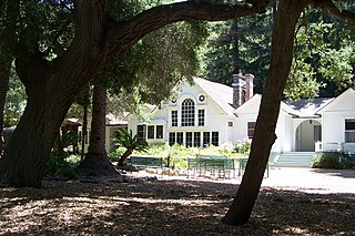
WModjeska House, also known as Arden, is a house designed by Stanford White in Modjeska Canyon, California. It is significant for being the only surviving home of Helena Modjeska, a Shakespearean actress and Polish patriot.
 W
WModjeska Peak is the northern mountain of Orange County's Saddleback formation. It is the second highest peak of the Santa Ana Mountains, and is in the Cleveland National Forest.
 W
WMorrell Canyon Creek is a stream or Arroyo, tributary to San Juan Creek, located in the Cleveland National Forest in Riverside County, California, at an elevation of 3,080 ft (939 m), in the Elsinore Mountains northeast of Elsinore Peak. It arises on the eastern slope of San Mateo Peak. An eastern fork draining the Morrell Potrero joins it a little over a mile north of its source and then flows northwestward about a third of a mile where it turns southeast descending the narrow Morrell Canyon east of Lion Spring. After descending 2.5 miles it turns north for half a mile then returns to a southwestern direction for another mile, the canyon widening here until it turns northwestward and down a steep canyon again for half a mile where it takes in from the right Decker Canyon Creek and Long Canyon Creek. It then turns southwestward again into a wider canyon and descends to its confluence with Bear Canyon Creek and becomes the head of San Juan Creek.
 W
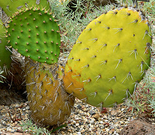
WOpuntia oricola is a species of prickly pear cactus known by the common name chaparral prickly pear. It is native to southern California and Baja California, where it grows in coastal sage scrub and chaparral habitats.
 W
WOso Creek is an approximately 13.5-mile (21.7 km) tributary of Arroyo Trabuco in southern Orange County in the U.S. state of California. Draining about 20 square miles (52 km2) in a region north of the San Joaquin Hills and south of the Santa Ana Mountains, the creek is Trabuco Creek's largest tributary, and is part of the San Juan Creek drainage basin. Beginning in the foothills of the Santa Ana Mountains near the city of Mission Viejo, the creek is dammed twice to form Upper Oso Reservoir and Lake Mission Viejo. The creek is channelized and polluted along much of its length.
 W
WRedonda Mesa is a mesa type formation located in the southern Santa Ana Mountains, near the Pacific Ocean in Southern California. It is located in an unincorporated area of southwestern Riverside County.
 W
WSaddleback, sometimes called Old Saddleback or Saddleback Mountain, is the landmark formed by the two highest peaks in the Santa Ana Mountains and the gap between them. Resembling a saddle as viewed from most of Orange County, California, this formation dominates the county's eastern skyline. On the clearest days, Saddleback is visible from most of the Greater Los Angeles area.
 W
WSalt Creek is a small coastal stream in southern Orange County in the U.S. state of California. The 4-mile (6.4 km) creek drains 6.1 square miles (16 km2) in parts of the cities of Laguna Niguel, Dana Point, and San Juan Capistrano. The mostly channelized creek has no named surface tributaries. The creek begins in the central portion of the city of Laguna Niguel and flows west and south through a narrow canyon referred to as the Salt Creek Corridor, which is mostly inside a long and narrow regional park. It then flows into the Monarch Beach Golf Course in the city of Dana Point and enters a subsurface storm channel which carries it to its discharge point at Salt Creek County Beach.
 W
WSan Juan Creek, also called the San Juan River, is a 29-mile (47 km) long stream in Orange County, California, draining a watershed of 133.9 square miles (347 km2). Its mainstem begins in the southern Santa Ana Mountains in the Cleveland National Forest. It winds west and south through San Juan Canyon, and is joined by Arroyo Trabuco as it passes through San Juan Capistrano. It flows into the Pacific Ocean at Doheny State Beach. San Juan Canyon provides a major part of the route for California State Route 74.
 W
WSan Mateo Creek is a stream in Southern California in the United States, whose watershed mostly straddles the border of Orange and San Diego Counties. It is about 22 miles (35 km) long, flowing in a generally southwesterly direction. Draining a broad valley bounded by the Santa Ana Mountains and Santa Margarita Mountains, San Mateo Creek is notable for being one of the last unchannelized streams in Southern California.
 W
WSan Mateo Peak is the unofficially named 3,591-foot (1,095 m) peak, at the western end of the ridge running west then northwest from Elsinore Peak to Morrell Canyon, south and west of the Morrell Potrero in the Elsinore Mountains of the Santa Ana Mountain Range. The peak name was given by Sierra Club Lower Peaks Committee Guide, originally named by Ken Croker who for 20 years maintained trails in the Santa Ana Mountains with volunteers from the Sierra Club. It remains officially nameless despite being the highest summit in the Elsinore Mountains, higher than Elsinore Peak, at 3536 ft., the highest named peak in those mountains.
 W
WThe Santa Ana River is the largest river entirely within Southern California in the United States. It rises in the San Bernardino Mountains and flows for most of its length through San Bernardino and Riverside Counties, before cutting through the northern Santa Ana Mountains via Santa Ana Canyon and flowing southwest through urban Orange County to drain into the Pacific Ocean. The Santa Ana River is 96 miles (154 km) long, and its drainage basin is 2,650 square miles (6,900 km2) in size.
WThe Santa Margarita Mountains are a mountain range, part of the larger Santa Ana Mountains in the Peninsular Ranges System. They are located in the coastal North County region of San Diego County, California.
 W
WThe Santa Rosa Plateau is an upland plateau and southeastern extension of the Santa Ana Mountains in Riverside County, southern California. It is bounded by the rapidly urbanizing Inland Empire cities of Murrieta and Temecula to the northeast and southeast, respectively.
WThe Santa Rosa Plateau is an upland plateau and southeastern extension of the Santa Ana Mountains in Riverside County, southern California. It is bounded by the rapidly urbanizing Inland Empire cities of Murrieta and Temecula to the northeast and southeast, respectively.
 W
WSantiago Canyon is an unincorporated community in Silverado, California. According to the 2000 census, Santiago Canyon has several hundred residents living within its borders. Trabuco Canyon and Modjeska Canyon are tributaries of Santiago Canyon. Santiago Creek flows northwest from the canyon, then west into the Santa Ana River. Neighborhood communities in Santiago Canyon include Santiago Canyon Estates and Falcon View Estates. The landmark Cook's Corner motorcycle restaurant is also located within Santiago Canyon.
 W
WSantiago Creek is a major watercourse in Orange County in the U.S. state of California. About 34 miles (55 km) long, it drains most of the northern Santa Ana Mountains and is a tributary to the Santa Ana River. It is one of the longest watercourses entirely within the county. The creek shares its name with Santiago Peak, at 5,687 ft (1,733 m) the highest point in Orange County, on whose slopes its headwaters rise.
 W
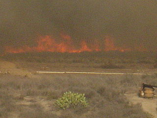
WThe Santiago Fire was a wildfire located near Santiago Canyon in Orange County, California, U.S., and one of thirty California wildfires of October 2007. The fire was intentionally started.
 W
WSantiago Peak is the southern mountain of Orange County's Saddleback formation. It is the highest and most prominent peak of both the Santa Ana Mountains and Orange County, and also marks a border point with Riverside County. The top of it is covered with many microwave and telecommunication antennas. It is named for Santiago Creek, which begins on its southwestern flank. During winter, snow does fall on the peak.
 W
WFounded in 1878, Silverado, a California Historical Landmark, is an unincorporated community in Silverado Canyon, which is located in the Santa Ana Mountains in eastern Orange County, California. Portions of the town sit on a former Mexican land grant Rancho Lomas de Santiago. Silverado is located at the boundaries of Cleveland National Forest. The area was mined for silver during the late 19th and early 20th centuries. Remnants of mining operations such as the Blue Light Mine are still scattered in the area. Timber was harvested for use by the railroad. Coal was mined at the time in Carbondale. Ancient sea life fossils can be found within the sandstone cliffs in the area. During Spanish rule, the canyon was visited by Spanish explorers and was known by the name Cañada de la Madera. The town in Spain by that name bears a remarkable resemblance to Silverado. The area enjoyed a renaissance in popularity in the 1940s as a hot springs vacation retreat, during which time hotels and restaurants prospered. Many weekend cabins were also built at that time. Home to a number of artists and craftsmen, the town now consists of about 2,000 residents, a general store, a cafe, a public library, a church, two fire stations, a community center, and a post office. It hosts summer concerts, an annual Country Fair, and an Easter breakfast. A local landmark near Silverado is Cook's Corner, popular with motorcyclists.
 W
WSulphur Creek is a 4.5-mile (7.2 km) tributary of Aliso Creek in Orange County in the U.S. state of California. The creek drains about 6 square miles (16 km2) of residential communities and parks in the southern San Joaquin Hills.
 W
WThe Temecula Valley AVA is an American Viticultural Area in the Temecula Valley, located in southwestern Riverside County, California.
WTenaja Canyon Creek, a stream or arroyo, tributary to San Mateo Creek, in the Cleveland National Forest in Riverside County, California. Its source is at an altitude of 1875 feet. The creek has its source at the confluence of arroyos from El Potrero del Tenaja, Redonda Mesa and Squaw Mountain highlands. and it flows northwestward 3 1/2 miles down Tenaja Canyon to its mouth and its confluence near Fishermans Camp, at an elevation of 1112 feet with San Mateo Creek.
 W
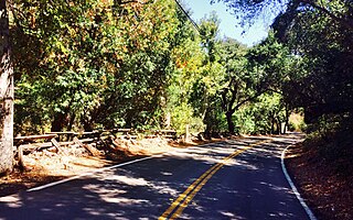
WTrabuco Canyon is a small unincorporated community located in the foothills of the Santa Ana Mountains in eastern Orange County, California, and lies partly within the Cleveland National Forest.
 W
WZerene eurydice, the California dogface butterfly, is sometimes placed in the related genus as Colias eurydice. This species is endemic to California, and is California's state insect symbol.