 W
WTemperate grasslands, savannas, and shrublands is a terrestrial biome defined by the World Wide Fund for Nature. The predominant vegetation in this biome consists of grass and/or shrubs. The climate is temperate and ranges from semi-arid to semi-humid. The habitat type differs from tropical grasslands in the annual temperature regime as well as the types of species found here.
 W
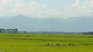
WAl-Hajar Mountains in northeastern Oman and also the eastern United Arab Emirates are the highest mountain range in the eastern Arabian peninsula. Also known as "Oman Mountains", they separate the low coastal plain of Oman from the high desert plateau, and lie 50–100 km (31–62 mi) inland from the Gulf of Oman.
 W
WThe Altai steppe and semi-desert ecoregion, as its name indicates, sits in a transition zine between steppe and semi-desert, supporting sparse grass and shrublands. The area is relatively undeveloped, with agriculture mostly represented by grazing livestock. There are a few shallow lakes in depressions used by migratory birds.
 W
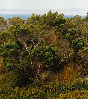
WThe Amsterdam and Saint-Paul Islands temperate grasslands is a temperate grasslands, savannas, and shrublands ecoregion comprising Île Amsterdam and Île Saint-Paul, two volcanic islands in the southern Indian Ocean.
 W
WAspen parkland refers to a very large area of transitional biome between prairie and boreal forest in two sections, namely the Peace River Country of northwestern Alberta crossing the border into British Columbia, and a much larger area stretching from central Alberta, all across central Saskatchewan to south central Manitoba and continuing into small parts of the US states of Minnesota and North Dakota. Aspen parkland consists of groves of aspen poplars and spruce interspersed with areas of prairie grasslands, also intersected by large stream and river valleys lined with aspen-spruce forests and dense shrubbery. This is the largest boreal-grassland transition zone in the world and is a zone of constant competition and tension as prairie and woodlands struggle to overtake each other within the parkland.
 W
WThe Baraba steppe, also known as Barabinsk steppe, Barabinskaya steppe Russian: Барабинская низменность, is a grassland steppe and wooded flat plain situated in western Siberia.
 W
WThe Canadian Prairies is a region in Western Canada. It includes the Canadian portion of the Great Plains and the Prairie Provinces, namely Alberta, Saskatchewan, and Manitoba. These provinces are partially covered by grasslands, plains, and lowlands, mostly in the southern regions. The northernmost reaches of the Canadian Prairies are less well known. They are marked by forests and more variable topography. If the region is defined to include areas only covered by prairie land, the corresponding region is known as the Interior Plains. Geographically, the Canadian prairies extend to northeastern British Columbia, but this province is not included in a political manner.
 W
WThe Canterbury-Otago tussock grasslands are an ecoregion of South Island, New Zealand.
 W
WThe Central Anatolian steppe is a Palearctic ecoregion in the temperate grasslands, savannas, and shrublands biome. It covers an area of 24,934 km2.
 W
WThe Chuya Steppe in the Siberian Altai Mountains is a depression formed by tectonic movement of major faults in the Earth's crust. Its name comes from the large river which runs through the steppe, the Chuya River.
 W
WThe Daurian forest steppe ecoregion is a band of grassland, shrub terrain, and mixed forests in northeast Mongolia and the region of Siberia, Russia that follows the course of the Onon River and Ulz River. The region has been described as a “sea of grass that forms the best and most intact example of an undisturbed steppe ecosystem and is also one of the last areas in the Palearctic that still supports stable herds of larger vertebrates” in a semi-mountainous area. The area also has flat wetlands that are important to migratory birds. The ecoregion is in the Palearctic realm, with a Cold semi-arid climate. It covers 209,012 km2 (80,700 sq mi).
 W
WThe Eastern Anatolian montane steppe is a temperate grasslands, savannas, and shrublands ecoregion. It is located in high plateau of Eastern Anatolia, covering parts of eastern Turkey, Armenia, Azerbaijan, southern Georgia, and northwestern Iran.
 W
WThe Mulga Lands are an interim Australian bioregion of eastern Australia consisting of dry sandy plains with low mulga woodlands and shrublands that are dominated by Acacia aneura (mulga). The Eastern Australia mulga shrublands ecoregion is coterminous with the Mulga Lands bioregion.
 W
WThe Emin Valley is located on the China-Kazakhstan border, in Central Asia. It has an area of about 65,000 square kilometres (25,000 sq mi). Its main waterway is the Emil River.
 W
WThe espinal (NT0801) is an ecoregion of dry, thorny forest, savanna and steppe in Argentina. It has been extensively modified by large scale cattle ranching, but remnants of the original flora remain. It is threatened by the advance of the irrigation-based agricultural frontier.
 W
WThe Eurasian Steppe, also called the Great Steppe or the steppes, is the vast steppe ecoregion of Eurasia in the temperate grasslands, savannas, and shrublands biome. It stretches from Bulgaria, Romania, Moldova, Ukraine, Western Russia, Siberia, Kazakhstan, Xinjiang, Mongolia, and Manchuria, with one major exclave, the Pannonian steppe or Puszta, located mostly in Hungary.
 W
WThe Faroe Islands boreal grasslands ecoregion covers all of the territory of the Faroe Islands, an archipelago of 18 islands in the North Atlantic, roughly equidistant between Scotland, Norway, and Iceland. The ground cover is mostly grassland and dwarf shrub heath, the remainder is bare ground or sparse vegetation. There are no forests on the islands.
 W
WA forest steppe is a temperate-climate ecotone and habitat type composed of grassland interspersed with areas of woodland or forest.
 W
WThe Gissaro-Alai open woodlands ecoregion covers the western foothills winding around two western offshoots of the Tian Shan Mountains in western Tajikistan, and parts of eastern Uzbekistan and western Kyrgyzstan, in Central Asia. The woodlands are typically of Juniper trees and shrubs, fitting the altitude zone situated between the desert valley floor, and the tree line, above which the mountain ridges are glaciated and barren.
 W
WThe Großes Torfmoor is a raised bog located in the northeast of the state of North Rhine-Westphalia in Germany south of the Mittelland Canal. It is between the town of Lübbecke and the community of Hille. The bog is a nature reserve and is under special protection from the European Union because of the bird species living there.
 W
WA heath is a shrubland habitat found mainly on free-draining infertile, acidic soils and is characterised by open, low-growing woody vegetation. Moorland is generally related to high-ground heaths with—especially in Great Britain—a cooler and damper climate.
 W
WThe Humid Pampas is an extensive ecoregion of flat, fertile grassland of loessic origin in Argentina. It has a precipitation average of 900 mm per year, in contrast with the Dry Pampas to the west, which average less than 700 mm.
 W
WKalmuk Steppe, or Kalmyk Steppe is a steppe with a land area of approximately 100,000 km², bordering the northwest Caspian Sea, bounded by the Volga on the northeast, the Manych on the southwest, and the territory of the Don Cossacks on the northwest. The historic home to the Kalmuck or Kalmyks it is in the Federal subject of Astrakhan Oblast in Russia. Before the appearance of the Kalmyks to this region, the area was long known as the Povoletsk steppe by the Russians.
 W
WThe Kazakh-Russian forest steppe ecoregion is a long thin strip of transition zone between the forested taiga of Siberian Russia, and the Kazakh steppe to the south. The ecoregion stretches over 2,000 km from the southern Ural mountains in the west to the foothills of Altai mountains in the east, yet averages only 200 km from south to north across its length. Because the region is farther inland than European forest steppe, and some 300 to 500 km farther north, the climate is more continental and with less precipitation the tree cover more sparse. The ecoregion is in the Temperate grasslands, savannas, and shrublands biome, and the Palearctic realm, with a Humid Continental climate. It covers 420,614 km2 (162,400 sq mi).
 W
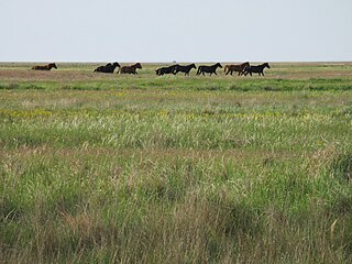
WThe Kazakh Steppe, also called the Great Dala, ecoregion, of the Palearctic temperate grasslands, savannas, and shrublands biome, is a vast region of open grassland in northern Kazakhstan and adjacent portions of Russia, extending to the east of the Pontic steppe and to the west of the Emin Valley steppe, with which it forms part of the Eurasian steppe. Before the mid-nineteenth century it was called the Kirghiz steppe, 'Kirghiz' being an old name for the Kazakhs.
 W
WThe Kazakh Uplands, also known as the Kazakh Hummocks, is a large peneplain formation extending throughout the central and eastern regions of Kazakhstan. It consists of low mountain oases and elevated plains, and contains large deposits of coal in the north and copper in the south. Rare species, such as the Asiatic cheetah, may still live in the region. Several notable cities, including the country's capital, Nur-Sultan, are located there.
 W
WThe Loita Plains are a savanna and pastoral grazing ground in the southern Great Rift Valley in Kenya, just north of the Maasai Mara.
 W
WThe Mongolian-Manchurian grassland ecoregion, also known as the Mongolian-Manchurian steppe, in the temperate grassland biome, is found in Mongolia, the Chinese Autonomous region of Inner Mongolia and Northeast China.
 W
WMoorland or moor is a type of habitat found in upland areas in temperate grasslands, savannas, and shrublands and montane grasslands and shrublands biomes, characterised by low-growing vegetation on acidic soils. Moorland, nowadays, generally means uncultivated hill land, but also includes low-lying wetlands. It is closely related to heath, although experts disagree on what precisely distinguishes both types of vegetation. Generally, moor refers to highland and high rainfall zones whereas heath refers to lowland zones which are more likely to be the result of human activity. Moorland habitats mostly occur in tropical Africa, northern and western Europe, and neotropical South America. Most of the world's moorlands are very diverse ecosystems. In the extensive moorlands of the tropics, biodiversity can be extremely high. Moorland also bears a relationship to tundra, appearing as the tundra and the natural tree zone. The boundary between tundra and moorland constantly shifts with climatic change.
WThe Mulga Lands are an interim Australian bioregion of eastern Australia consisting of dry sandy plains with low mulga woodlands and shrublands that are dominated by Acacia aneura (mulga). The Eastern Australia mulga shrublands ecoregion is coterminous with the Mulga Lands bioregion.
 W
WAn oak savanna is a type of savanna-or lightly forested grassland- where oaks are the dominant trees, the term oakery or woodlands is also used commonly, though the former is more prevalent when referencing the Mediterranean area. These savannas were maintained historically through wildfires set by lightning, humans, grazing, low precipitation, and/or poor soil.
 W
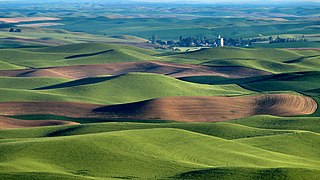
WThe Palouse is a distinct geographic region of the northwestern United States, encompassing parts of north central Idaho, southeastern Washington, and, by some definitions, parts of northeast Oregon. It is a major agricultural area, primarily producing wheat and legumes. Situated about 160 miles (260 km) north of the Oregon Trail, the region experienced rapid growth in the late 19th century.
 W
WThe Pampas are fertile South American lowlands that cover more than 1,200,000 square kilometres (460,000 sq mi) and include the Argentine provinces of Buenos Aires, La Pampa, Santa Fe, Entre Ríos, and Córdoba; all of Uruguay; and Brazil's southernmost state, Rio Grande do Sul. The vast plains are a natural region, interrupted only by the low Ventana and Tandil hills, near Bahía Blanca and Tandil (Argentina), with a height of 1,300 m (4,265 ft) and 500 m (1,640 ft), respectively.
 W
WThe Patagonian Desert, also known as the Patagonian Steppe is the largest desert in Argentina and is the 8th largest desert in the world by area, occupying 673,000 square kilometers (260,000 mi2). It is located primarily in Argentina and is bounded by the Andes, to its west, and the Atlantic Ocean to its east, in the region of Patagonia, southern Argentina. To the north the desert grades into the Cuyo Region and the Monte. The central parts of the steppe are dominated by shrubby and herbaceous plant species albeit to the west, where precipitation is higher, bushes are replaced by grasses. Topographically the deserts consist of alternating tablelands and massifs dissected by river valleys and canyons. The more western parts of the steppe host lakes of glacial origin and grades into barren mountains or cold temperate forests along valleys.
 W
WThe Pontic steppe or Pontic–Caspian steppe is the steppeland stretching from the northern shores of the Black Sea as far east as the Caspian Sea, from Dobruja in the northeastern corner of Bulgaria and southeastern Romania, through Moldova and eastern Ukraine across Russian Northern Caucasus, Southern and lower Volga regions to western Kazakhstan, adjacent to the Kazakh steppe to the east, both forming part of the larger Eurasian steppe. It is a part of the Palearctic realm and the temperate grasslands, savannas, and shrublands biome.
 W
WPre-Columbian savannas of North America, consisting of a mixed woodland-grassland ecosystem, were maintained by both natural lightning fires and by Native Americans before the significant arrival of Europeans. Although decimated by widespread epidemic disease, Native Americans in the 16th century continued using fire to clear savanna until European colonists began colonizing the eastern seaboard. Many colonists continued the practice of burning to clear underbrush, reinforced by their similar experience in Europe, but some land reverted to forest.
 W
WRangelands are grasslands, shrublands, woodlands, wetlands, and deserts that are grazed by domestic livestock or wild animals. Types of rangelands include tallgrass and shortgrass prairies, desert grasslands and shrublands, woodlands, savannas, chaparrals, steppes, and tundras. Rangelands do not include forests lacking grazable understory vegetation, barren desert, farmland, or land covered by solid rock, concrete and/or glaciers.
 W
WA savanna or savannah is a mixed woodland-grassland ecosystem characterised by the trees being sufficiently widely spaced so that the canopy does not close. The open canopy allows sufficient light to reach the ground to support an unbroken herbaceous layer consisting primarily of grasses.
 W
WThe Sayan intermontane steppe ecoregion is sometimes referred to as a "steppe island", being an expanse of grassland and shrubs surrounded by mountain forests in the Tyva Republic of south central Siberia, Russia. The Altai Mountains are to the west, the Sayan Mountains to the north, and the Tannu-Ola Mountains to the south. The ecoregion is in the temperate grasslands, savannas, and shrublands biome, and the Palearctic realm, with a Humid Continental climate. For much of its length, it follows the course of the upper Yenisei River. It covers 33,928 km2 (13,100 sq mi).
 W
WThe Selenge-Orkhon forest steppe ecoregion stretches across north central Mongolia, and follows the Selenga River northeast into Russia. The ecoregion is itself at high elevations, but surrounded by higher mountain ranges. As a transition zone between taiga and steppe, it features conifer forests on the north slopes of mountains, and pine/aspen stands on southern slopes. It has an area of 227,660 square kilometres (87,900 sq mi).
 W
WThe shortgrass prairie is an ecosystem located in the Great Plains of North America. The prairie includes lands to the west as far as the eastern foothills of the Rocky Mountains and extends east as far as Nebraska and north into Saskatchewan. The prairie stretches through parts of Alberta, Wyoming, Montana, North Dakota, South Dakota, and Kansas, and passes south through the high plains of Colorado, Oklahoma, Texas, and New Mexico.
 W
WShrub-steppe is a type of low-rainfall natural grassland. While arid, shrub-steppes have sufficient moisture to support a cover of perennial grasses or shrubs, a feature which distinguishes them from deserts.
 W
WThe South Siberian forest steppe ecoregion is a patchwork of grasslands and forests in the low-lying areas of south central Siberia. The region is one of high biodiversity as a transition zone between the West Siberian taiga to the north, and the Altai mountains to the south. There are also small patches to the east in Irkutsk Oblast. The ecoregion is in the temperate grasslands, savannas, and shrublands biome, and the Palearctic realm, with a Humid Continental climate. It covers 161,874 km2 (62,500 sq mi).
 W
WThe Southeast Australia temperate savanna ecoregion is a large area of grassland dotted with eucalyptus trees running north–south across central New South Wales, Australia.
WIn physical geography, a steppe is an ecoregion characterized by grassland plains without trees apart from those near rivers and lakes. Steppe biomes may include:the montane grasslands and shrublands biome the temperate grasslands, savannas and shrublands biome
 W
WSumapaz Páramo is a large páramo ecosystem located in the Altiplano Cundiboyacense mountain range, considered the largest páramo ecosystem in the world. It was declared a National Park of Colombia in 1977 because of its importance as a biodiversity hotspot and main source of water for the most densely populated area of the country, the Bogotá savanna.
 W
WThe tallgrass prairie is an ecosystem native to central North America. Natural and anthropogenic fire, as well as grazing by large mammals, were historically agents of periodic disturbance, which regulates tree encroachment, recycles nutrients to the soil, and catalyzes some seed dispersal and germination processes. Prior to widespread use of the steel plow, which enabled large scale conversion to agricultural land use, tallgrass prairies extended throughout the American Midwest and smaller portions of southern central Canada, from the transitional ecotones out of eastern North American forests, west to a climatic threshold based on precipitation and soils, to the southern reaches of the Flint Hills in Oklahoma, to a transition into forest in Manitoba.
 W
WTanner Moor is one of the largest moorlands in Austria with a surface area of 120 hectares. Tanner Moor is a Natura 2000 ecologically protected area located on a high granite plateau in the Freistadt district, Mühlviertel, Upper Austria at an average elevation of 900 m.
 W
WThe Tian Shan foothill arid steppe ecoregion covers the northern and western approaches to the Tian Shan mountains, centered on Lake Issyk-Kul in Kyrgyzstan. This region receives more moisture from Central Asia, thereby supporting more vegetation and diversity of plant and animal species than the deserts to the south.
 W
WThe Tristan da Cunha–Gough Islands shrub and grasslands is a terrestrial ecoregion which covers the Tristan da Cunha archipelago and Gough Island in the South Atlantic Ocean. The islands' remote location gave rise to many endemic species.
 W
WTussock grasslands form expansive and distinctive landscapes in the South Island and to a lesser extent in the central plateau region of the North Island of New Zealand. Most of the plants referred to as tussocks are in the genera Carex, Chionochloa, Festuca, and Poa.
 W
WThe West Siberian Plain, also known as Zapadno-sibirskaya Ravnina, is a large plain that occupies the western portion of Siberia, between the Ural Mountains in the west and the Yenisei River in the east, and by the Altay Mountains on the southeast. Much of the plain is poorly drained and consists of some of the world's largest swamps and floodplains. Important cities include Omsk, Novosibirsk, Tomsk and Chelyabinsk.