 W
WNusantara is the Indonesian/Malay name of Maritime Southeast Asia. It is an Old Javanese term which literally means "outer islands". In Indonesia, it is generally taken to mean the Indonesian Archipelago, while in Malaysia, the term has been adopted to mean the Malay Archipelago.
 W
WThe Alor Archipelago is located at the eastern Lesser Sunda Islands.
 W
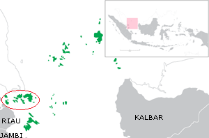
WAnambas Islands Regency is a small archipelago of Indonesia, located 150 nautical miles northeast of Batam Island in the North Natuna Sea between the Malaysian mainland to the west and the island of Borneo to the east. Geographically part of the Tudjuh Archipelago, it is administratively a regency within the Riau Islands Province. It covers a land area of 590.2 square kilometres (227.9 sq mi) and had a population of 37,411 at the 2010 Census. The administrative centre is at Tarempa on Siantan Island.
 W
WThe Aru Islands Regency are a group of about ninety-five low-lying islands in the Maluku province of eastern Indonesia. They also form a regency of Maluku, with a land area of 8,152.42 square kilometres. At the 2011 Census the Regency had a population of 84,138; the latest official estimate was 93,722.
 W
WThe Asia Islands are a group of three small islands in the open sea north of the Raja Ampat Archipelago of eastern Indonesia. They are located 117 kilometres (73 mi) north of the island of Waigeo, around 50 kilometres (31 mi) north of the last of the Ayu Islands, and 210 kilometres (130 mi) south of the island of Tobi in Palau. The individual islands are known as Fani, Igi and Miarin. On the largest island of Fani, there is a pier and a small settlement, intermittently inhabited by visitors from Reni and Rutum. Administratively the Asia Islands are part of the Raja Ampat Regency of the province of West Papua.
 W
WThe Ayu Islands, are a small archipelago south of the Asia Islands and north of Raja Ampat Islands in Indonesia. This group is formed by two coral atolls. The highest point is 106 m.
 W
WThe Babar Islands (Indonesian: Kepulauan Babar) are located in Maluku Province, Indonesia between latitudes 7 degrees 31 minutes South to 8 degrees 13 minutes South and from longitudes 129 degrees 30 minutes East to 130 degrees 05 minutes East. The group now constitutes five districts (kecamatan) within the Maluku Barat Daya Regency of Maluku province.
 W
WThe Bacan Islands, formerly also known as the Bachans, Bachians, and Batchians, are a group of islands in the Moluccas in Indonesia. They are mountainous and forested, lying south of Ternate and southwest of Halmahera. The islands are administered by the South Halmahera Regency of North Maluku Province. They formerly constituted the Sultanate of Bacan.
 W
WThe Banda Arc is a set of island arcs that exist in eastern Indonesia. It manifests the collision of a continent and an intra-oceanic island arc. The presently active arc is located on what appears to be oceanic crust whereas the associated subduction trench is underlain by continental crust. The convergence of the Indo-Australian plates and Eurasia and resulted in the formation of the Sunda and Banda island arcs. The transitional zone between the arcs is located south of Flores Island and is characterized by the change in the tectonic regime along the boundary.
 W
WThe Banda Islands are a volcanic group of ten small volcanic islands in the Banda Sea, about 140 km (87 mi) south of Seram Island and about 2,000 km (1,243 mi) east of Java, and constitute an administrative district (kecamatan) within the Central Maluku Regency in the Indonesian province of Maluku. The main town and administrative centre is Bandanaira, located on the island of the same name. They rise out of 4-to-6-kilometre deep ocean and have a total land area of approximately 172 square kilometres (66 sq mi). They had a population of 18,544 at the 2010 Census. Until the mid-19th century the Banda Islands were the world's only source of the spices nutmeg and mace, produced from the nutmeg tree. The islands are also popular destinations for scuba diving and snorkeling.
 W
WThe Banyak Islands are a group of inhabited islands located between Simeulue and Nias off the western coast of Sumatra in Indonesia's Aceh Province. Surveys of the area approximate around 71 islands and additional mangrove stands in shallow off-shore areas, although locals count 99 islands. The largest island in the group is Tuangku, with the principal town of Haloban. Two other major islands located either side of Tuangku are Bangkaru and Ujung Batu. Tuangku is separated from Bangkaru by a fault line.
 W
WThe Barat Daya Islands are a group of islands in the Maluku province of Indonesia. The Indonesian phrase barat daya means 'south-west'.
 W
WThe Batu Islands are an archipelago of Indonesia located in the Indian Ocean, off the west coast of Sumatra, between Nias and Siberut. The three primary islands, of approximately equal size, are Pini, Tanahmasa, and Tanahbala. There are forty-eight smaller islands, of which the largest are Sipika, Simuk, Bodjo, Telo and Sigata; less than half are inhabited. The total land area of the seven administrative districts is 1,201.1 km2. The islands are governed as a part of South Nias regency within North Sumatra province. In Indonesian and Malay, batu means rock or stone.
 W
WThe Schouten Islands are an island group of Papua province, eastern Indonesia in the Cenderawasih Bay 50 km off the north-western coast of the island of New Guinea. The group consists of the main islands of Biak, Supiori and Numfor, and numerous smaller islands, mostly covered in rain forest.
 W
W.
 W
WThe Bunguran Islands are an archipelago in Riau Islands province, Indonesia, located in the Natuna Sea, the southern portion of the South China Sea. The archipelago forms the central part of the Natuna Regency, an archipelago of 272 islands in total, which is in turn included in the Tudjuh Archipelago, off the northwest coast of Borneo. The largest island of the archipelago is Bunguran or Pulau Natuna Besar, situated in the Middle Natuna Archipelago. The group covers a land area of 1,698.6 km2 and had a population of 52,013 at the 2010 Census. It is divided into nine districts (kecamatan) – seven of which are tabulated below from north to south with their areas and 2010 Census populations, plus the number of administrative villages within that district and the postcode:
 W
WThe Derawan Islands are in the province of East Kalimantan in Indonesia. They consist of 31 islands, most well known among these are the islands of Derawan, Maratua, Sangalaki and Kakaban. There are also numerous submerged reefs and islets. They are located in the Sulawesi Sea, on the coastal shelf of East Kalimantan. The islands are part of the Berau Regency.
 W
WFam Islands are a group of islands in the Raja Ampat Archipelago, which are administered as part of the Indonesian province of West Papua. The main islands are Fam, Penemu, Inus and Yar. They lie northwest of Batanta island, in the straits between Waigeo and Batanta and New Guinea.
WThe Schouten Islands are an island group of Papua province, eastern Indonesia in the Cenderawasih Bay 50 km off the north-western coast of the island of New Guinea. The group consists of the main islands of Biak, Supiori and Numfor, and numerous smaller islands, mostly covered in rain forest.
WThe Gorom archipelago is a group of islands situated between the Watubela archipelago and Ceram in the Maluku Islands.
 W
WThe Greater Sunda Islands are four tropical islands situated within Southeast Asia, in the Pacific Ocean. The islands, Borneo, Java, Sulawesi and Sumatra, are internationally recognised for their ecological diversity and rich culture.
 W
WThe Kai Islands of Indonesia are a group of islands in the southeastern part of the Maluku Islands, located in the province of Maluku. The Moluccas have been known as the Spice Islands due to regionally specific plants such as nutmeg, mace, and cloves that originally intrigued the European nations of the 16th century.
 W
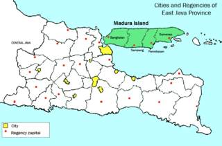
WThere are 38 Kangean Islands altogether with 6 inhabited, forming an archipelago that is part of Indonesia covering a total space of 668 square km. They are located in the Java Sea approximately 120 km (75 mi) north of Bali and 120 km east of Madura Island. The islands are administratively a part of Sumenep Regency within East Java province.
 W
WThe Karimata Islands are a chain of small islands off the west coast of Indonesian Borneo, the largest of which is (Pulau) Karimata, being about 20 km (12 mi) across (east-west), and situated at 1°37′S 108°53′E. It is part of Kayong Utara Regency of West Kalimantan province in Indonesia. Karimata has a wide range of ecosystems, from mangroves and tropical rain forest in the lowlands to montane shrubland on the summit of the c.1,000 m (3,281 ft) mountain. The mountain is composed of granite. A substantial population of cave swiftlets has historically been the source of birds nests for birds nest soup, but has decreased recently to near extirpation, due to overharvesting by non-indigenous collectors who have been arriving from the mainland. A number of small villages are situated on the coast, the largest of which is Padang, on the eastern tip of the island. The island is renowned by inhabitants of the west coast of Kalimantan to have a serious malaria problem.
 W
WKarimunjawa Islands or Karimunjava Islands is an archipelago of 27 islands in the Java Sea, Indonesia, approximately 80 kilometres northwest of Jepara. They have a total land area of 71.2 km2. The main island is known as Karimun, while the second-largest island is Kemujan.
 W
WThe Krakatoa Archipelago is a small uninhabited archipelago of volcanic islands formed by the Krakatoa stratovolcano located in the Sunda Strait, nestled between the much larger islands of Java and Sumatra. As of 2018, the archipelago consists of four main islands: Verlaten, Lang, Rakata, and the currently volcanically active Anak Krakatoa. Together, the islands are a part of the Indonesian island arc system, created by the northeastward subduction of the Indo-Australian Plate. As part of a dynamic volcanic system, the islands have been continuously reshaped throughout recorded history, most notably in the 1883 eruption of Krakatoa.
 W
WThe Lease Islands, formerly called the Uliasers or Uliassers, are a group of three inhabited islands, lying immediately to the south of Seram and east of Ambon Island in the province of Maluku, in Indonesia. The three inhabited islands, from west to east, are Haruku, Saparua, Nusa Laut and tiny uninhabited Molana; these islands constitute four administrative districts (kecamatan) within Central Maluku Regency.
 W
WThe Lesser Sunda Islands are a group of islands in Maritime Southeast Asia, north of Australia. Together with the Greater Sunda Islands to the west they make up the Sunda Islands. The islands are part of a volcanic arc, the Sunda Arc, formed by subduction along the Sunda Trench in the Java Sea.
 W
WThe Leti Islands of Indonesia are part of the Maluku Islands, in southwest Maluku Province. The main islands are Moa, Leti and Lakor; each of the three islands now constitutes a separate administrative district (kecamatan) within the Maluku Barat Daya Regency
 W
WThe Lingga Regency is a group of islands in Indonesia, located south of Singapore, along both sides of the equator, off the eastern coast of Riau Province on Sumatra island. They are south of the populated Riau Archipelago, known for the industrial island of Batam and the tourist-frequented island of Bintan, although the Lingga Islands themselves are rarely visited due to the infrequent local transportation. The equator goes through the northern tip of Lingga, the name of the main island in the archipelago.
 W
WLucipara Islands are about 50 km west of Penyu Islands, both of which belong to Molucca Islands. They are directly south of Manipa Strait near Ceram.
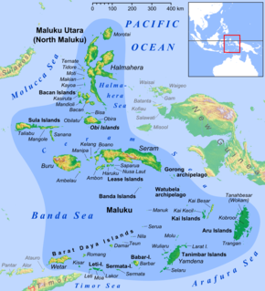
WThe Maluku Islands or the Moluccas (Molukken) are an archipelago in eastern Indonesia. Tectonically they are located on the Halmahera Plate within the Molucca Sea Collision Zone. Geographically they are located east of Sulawesi, west of New Guinea, and north and east of Timor.
 W
WThe Masalembu Islands lie in the Java Sea to the north of Madura, about halfway between Madura and Borneo. They administratively form Masalembu District (kecamatan) of Sumenep Regency of Madura, in the Indonesian province of East Java. The Madurese language is spoken on the islands. The three main islands are Masalembu Island, Masakambing Island, and Karamian Island. The land area of the district is 40.85 square km, and they had a population of 20,687 people in the 2000 census, increasing to 21,705 at the 2010 Census; the latest estimate as at 2015 is 23,751.
 W
WThe Mentawai Islands Regency are a chain of about seventy islands and islets approximately 150 kilometres off the western coast of Sumatra in Indonesia. They cover 6,011.35 sq2 and had a population of 76,173 at the 2010 Census and 85,156 at the 2015 Census; the latest official estimate is 93,070. Siberut at 4,030 square kilometres is the largest of the islands. The other major islands are Sipura, North Pagai and South Pagai. The islands lie off the Sumatran coast, across the Mentawai Strait. They cover The indigenous inhabitants of the islands are known as the Mentawai people. The Mentawai Islands have become a noted destination for surfing, with over 40 boats offering surf charters to international guests.
 W
WThe Natuna Regency is an archipelago of 272 islands located in the south part of the South China Sea in the Natuna Sea. It is part of the larger Tudjuh Archipelago, off the northwest coast of Borneo. Administratively, the islands constitute a regency within the Riau Islands Province of Indonesia and are the northernmost non-disputed island group of Indonesia.
WThe Obi Islands are a group of islands in the Indonesian province of North Maluku. They lie north of Buru and Ceram. They cover a land area of 2,823.43 km2, and had a population of 41,455 at the 2010 Census, which had risen to about 46,080 by 2018.
 W
WLocated off the northwest tip of Bird's Head Peninsula on the island of New Guinea, in Indonesia's West Papua province, Raja Ampat, or the Four Kings, is an archipelago comprising over 1,500 small islands, cays, and shoals surrounding the four main islands of Misool, Salawati, Batanta, and Waigeo, and the smaller island of Kofiau.
 W
WThe Riau Archipelago is a geographic term for the core group of islands within the Riau Islands Province in Indonesia, and located south of Singapore. Before the province of Riau Islands was formed, there was no ambiguity in term; however, in Indonesian language, both the archipelago and administrative province are referred to as simply "Kepulauan Riau". The province may have the word "Provinsi" preceding it for clarity. Additionally the term BBK for Batam Bintan Karimun may refer to the archipelago.
 W
WThe Sangihe Islands – Indonesian: Kepulauan Sangihe – are a group of islands which constitute two regencies within the province of North Sulawesi, in northern Indonesia, the Sangihe Islands Regency and the Sitaro Islands Regency. They are located north-east of Sulawesi between the Celebes Sea and the Molucca Sea, roughly halfway between Sulawesi and Mindanao, in the Philippines; the Sangihes form the eastern limit of the Celebes Sea. The islands combine to total 813 square kilometers (314 sq mi), with many of the islands being actively volcanic with fertile soil and mountains.
 W
WSapudi Islands are a group of 14 islands that lie between Madura Island and the Kangean islands of Indonesia. It is part of the Greater Sunda Islands and is located in the Java Sea. The Sapudi Islands are administered as three kabupaten (districts) of Sumenep Regency in the state of East Java. The land area is 167.38 km2, and there was a population of 82,024 at the 2010 Census. The Madurese language is spoken on the islands.
WThe Schouten Islands are an island group of Papua province, eastern Indonesia in the Cenderawasih Bay 50 km off the north-western coast of the island of New Guinea. The group consists of the main islands of Biak, Supiori and Numfor, and numerous smaller islands, mostly covered in rain forest.
 W
WThe Solor Archipelago is a group of islands in the Lesser Sunda Islands, Indonesia, lying to the east of Flores and to the west of the Alor Strait and the Alor Archipelago. To the north is the west part of the Banda Sea, while to the south across the Savu Sea lies the island of Timor. The largest islands are, from west to east, Solor, Adonara, and Lembata, although there are many small islands as well.
 W
WThe Spermonde Archipelago is a group of around 120 islands off the southwest coast of Sulawesi in Indonesia, located within the Coral Triangle, between the southern arc of Sulawesi and the Strait of Makassar. Situated west of Makassar, the archipelago covers approximately 2,500 km2, and comprises around 50 vegetated islands and 70 unvegetated sand cays. About 50 islands are inhabited, collectively home to around 50,000 people.
WThe Maluku Islands or the Moluccas (Molukken) are an archipelago in eastern Indonesia. Tectonically they are located on the Halmahera Plate within the Molucca Sea Collision Zone. Geographically they are located east of Sulawesi, west of New Guinea, and north and east of Timor.
WThe Sunda Islands are a group of islands in the Malay Archipelago.
 W
WThe Taka Bonerate Islands in Indonesia consist of 28 atoll islands, together with the larger island of Kayuadi lying west of the atoll. They lie about 3 to 4 hours by boat from Benteng, the administrative capital of the Selayar Islands. Together they make up the Takabonerate District of Selayar Regency in South Sulawesi Province. It is part of a National Marine Park, with dive sites, pelagic fishes, dolphins, turtles, many soft corals, sea fans. Also it is the third largest atoll in the world.
 W
WTalaud Islands is a group of islands located north of Sulawesi island in Indonesia, north-east of the Sangihe Islands. and The Talaud Islands are also the northernmost region of Eastern Indonesia, bordering south of the Philippines' Davao Region. The group, with a total area of 495 square miles, includes Karakelong, Salibabu, Kabaruan, and numerous islets. The coast of Karakelong Island is steep except on the southern shore, which is fringed by a wide reef. The seven tiny Nanusa Islands lie north-east of Karakelong. They are forested and with hills rising to 2,231 feet. Talaud Islands are the home of the Sangirese people a tribe in Davao of Mindanao island in the Philippines which was separated during the colonial era when the border of Indonesia and the Philippines was established.
 W
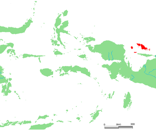
WThe Tanimbar Islands, also called Timur Laut, are a group of about 65 islands in the Maluku province of Indonesia, including Fordata, Larat, Maru, Molu, Nuswotar, Selaru, Selu, Seira, Wotap, Wuliaru and Yamdena. The Indonesian phrase timur laut means "east of the sea" or "northeast".
 W
WThe Tayandu or Tayando Islands are a group of low-lying islands just west of the larger Kai Islands of Maluku, Indonesia. The main group consists of Tayando, Walir, Heniar and several smaller isle-lets. Between Walir and Taam is Pulau Nusreen featuring a large sandy lagoon. Manggur is further west with Kur and Kaimeer islands north of it. Administratively they comprise a district (kecamatan) within the city of Tual.
 W
WThe Thousand Islands are a chain of islands to the north of Jakarta's coast. It forms the only regency of Jakarta, the capital of Indonesia. It consists of a string of 342 islands stretching 45 km (28 mi) north into the Java Sea at West Jakarta Bay and in fact north of Banten Province.
 W
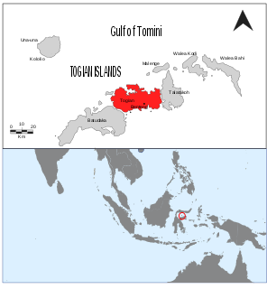
WThe Togian Islands are an archipelago of 56 islands and many offshore islets, situated in the Gulf of Tomini, off the coast of Central Sulawesi, in Indonesia. The largest islands are Batudaka, Togean, Talatako and Una-Una. There are 37 villages on the islands, with one settled by the Bajau people, more commonly known as the sea gypsies.
 W
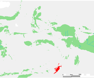
WWakatobi Regency is a group of ca. 150 islands forming an administrative regency located in Southeast Sulawesi, Indonesia. The capital of the regency is located on Wangi-wangi Island, and was established by virtue of Law of the Republic of Indonesia Number 29 of 2003 dated 18 December 2003. The regency has an area of 473.62 square kilometers and had a population of 92,922 at the 2010 Census; the latest official estimate was 95,386 inhabitants.
WWatubela is an archipelago in the Maluku Islands, east of Ceram and north of Kai Islands, southeast of the Gorong archipelago, and southwest of the Bomberai Peninsula of Papua, Indonesia. It includes the islands of Kasiui and Teor.