 W
WBanff National Park is Canada's oldest national park, established in 1885. Located in Alberta's Rocky Mountains, 110–180 kilometres (68–112 mi) west of Calgary, Banff encompasses 6,641 square kilometres (2,564 sq mi) of mountainous terrain, with many glaciers and ice fields, dense coniferous forest, and alpine landscapes. The Icefields Parkway extends from Lake Louise, connecting to Jasper National Park in the north. Provincial forests and Yoho National Park are neighbours to the west, while Kootenay National Park is located to the south and Kananaskis Country to the southeast. The main commercial centre of the park is the town of Banff, in the Bow River valley.
 W
WAbbot Pass lies between Mount Lefroy and Mount Victoria, in the divide between the valleys of Lake O'Hara and Lake Louise. It was named for Philip Stanley Abbot who died in 1896 in an attempt to climb Mount Lefroy with Charles Fay, Charles Thompson, and George T. Little.
 W
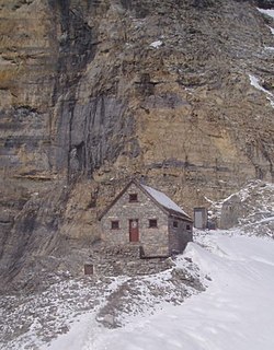
WThe Abbot Pass hut is an alpine hut located at an altitude of 2925 metres in Abbot Pass in the Rocky Mountains in Alberta, Canada. It is nestled between Mount Victoria and Mount Lefroy, straddling the continental divide, which, in this region, defines the boundary between Banff National Park in Alberta and Yoho National Park in British Columbia. While close to the border, the hut lies entirely in Banff National Park, and is the second-highest permanently habitable structure in Canada. The hut is maintained by the Alpine Club of Canada.
 W
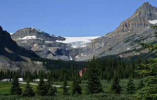
WThe Alexandra River is a tributary of the North Saskatchewan River in Alberta, Canada. Its source is an unnamed lake at 1,563 metres (5,128 ft) of elevation, which is fed by the Alexandra Glacier. From there it flows for about 20 kilometres (12 mi) through a remote valley until it reaches its mouth at the North Saskatchewan River. There are no navigable roads in the river's valley, but a decommissioned hiking trail does follow the north bank upstream until the river's confluence with the Castleguard River. The trail eventually reaches the Castleguard Meadows, a revered but seldom-visited hiking destination.
 W
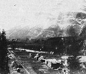
WAnthracite is a ghost town located within Banff National Park in southern Alberta, Canada. It is named after the anthracite variety of coal.
 W
WBanff Airport,, is located 1.7 nautical miles northeast of Banff, Alberta, Canada. It is operated by Parks Canada, as it is located within Banff National Park.
Banff Lodging Company is a locally owned and operated hospitality company in the Banff National Park.
 W
WBanff Sunshine Village is a ski resort in western Canada, located on the Continental Divide of the Canadian Rockies within Banff National Park in Alberta and Mt Assiniboine Provincial Park in British Columbia. It is one of three major ski resorts located in the Banff National Park. Because of its location straddling the Continental Divide, Sunshine receives more snow than the neighbouring ski resorts. The Sunshine base area is located 15 km (9 mi) southwest of the town of Banff. By car, it is about a ninety-minute drive from the city of Calgary; the Sunshine exit on the Trans Canada Highway is 8 km (5 mi) west of the town of Banff.
 W
WBanff Upper Hot Springs are commercially developed hot springs located in Banff National Park in Alberta, Canada, near the Banff townsite. Discovered in 1883, the hot pool is outdoors and while in the pool, visitors can look across the valley to Mount Rundle. It is located at 1,585 metres (5,200 ft) of elevation, which makes it the highest hot spring in Canada.
 W
WBankhead, Alberta was a small coal mining town that existed in the early twentieth century, in Banff National Park, near the town of Banff, Alberta. The mine was located at Cascade Mountain, which contains high grade anthracite coal deposits. The Bankhead coal mine was operated by the Pacific Coal Company, a subsidiary of the Canadian Pacific Railway, which needed the coal to fuel its steam engines. The mine began operations in 1903 and was the first anthracite mine in Canada.
 W
WBourgeau Lake is a rock-rimmed alpine lake at the foot of Mount Bourgeau near Banff, in Banff National Park, Alberta. It is a popular hiking destination. The trailhead is located at the Bourgeau Lake parking lot on the southwest side of the Trans-Canada Highway, 2.9 km (1.8 mi) from the turnoff for the Banff Sunshine ski resort. The hike takes on average 2.5 to 3 hours one way and ascends 725 m (2,380 ft) to a maximum elevation of 2,160 m (7,090 ft) The trail to the summit of Mt. Bourgeau starts at the western end of the lake.
 W
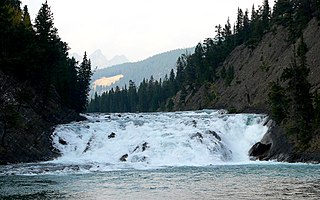
WBow Falls is a major waterfall on the Bow River, Alberta just before the junction of it and the Spray River. They are located near the Banff Springs Hotel and golf course on the left-hand side of River Road.
 W
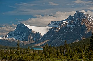
WBow Glacier is located in Banff National Park, Alberta, Canada, approximately 37 km (23 mi) northwest of Lake Louise. It can be viewed from the Icefields Parkway. Bow Glacier is an outflow glacier from the Wapta Icefield, which rests along the Continental Divide, and runoff from the glacier supplies water to Bow Lake and the Bow River. The glacier is credited for creating the Bow Valley before retreating at the end of the last glacial maximum.
 W
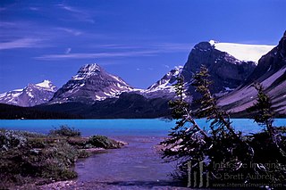
WBow Lake is a small lake in western Alberta, Canada. It is located on the Bow River, in the Canadian Rockies, at an altitude of 1920 m.
 W
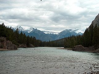
WThe Bow River is a river in Alberta, Canada. It begins within the Canadian Rocky Mountains and winds through the Alberta foothills onto the prairies, where it meets the Oldman River, the two then forming the South Saskatchewan River. These waters ultimately flow through the Nelson River into Hudson Bay. The Bow River runs through the city of Calgary, taking in the Elbow River at the historic site of Fort Calgary near downtown. The Bow River pathway, developed along the river's banks, is considered a part of Calgary's self-image.
 W
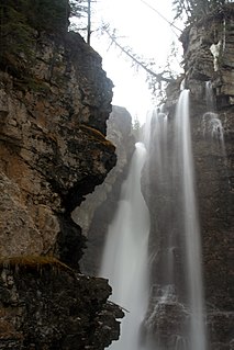
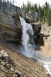
WBridal Veil Fall is a waterfall in Banff National Park, Alberta, Canada. It originates in the Huntington Glacier on the slopes of Cirrus Mountain. Its waters drain into Nigel Creek, then into the North Saskatchewan River at the Big Bend of the Icefields Parkway.
 W
WCastle Junction is a locality where the northern extent of the Banff–Windermere Highway intersects with the Trans-Canada Highway, the Bow River, and Bow Valley Parkway in Banff National Park, Alberta. It is named after the nearby Castle Mountain, clearly visible from the junction. The area is also referred to as Castle Mountain; however, the official location is approximately 1.6 km (1.0 mi) southwest of Castle Junction along the Canadian Pacific Railway.
 W
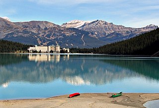
WThe Fairmont Chateau Lake Louise is a Fairmont hotel on the eastern shore of Lake Louise, near Banff, Alberta. The original hotel was gradually developed at the turn of the 20th century by the Canadian Pacific Railway and was thus "kin" to its predecessors, the Banff Springs Hotel and the Château Frontenac. The hotel's wooden Rattenbury Wing was destroyed by fire on 3 July 1924, and was replaced by the current Barrot Wing one year later. The Painter Wing, built in 1913, is the oldest existing portion of the hotel. The Mount Temple Wing, opened in 2004, is the most recent wing and features modern function facilities; these include the Mount Temple Ballroom.
 W
WThe Cory Pass Loop is a trail located in Banff National Park. The Pass is located outside the city of Banff, Alberta, between Mount Edith and Mount Cory. The pass opens up to Gargoyle Valley; the trail continues around the east side of Mount Edith returning to the original trail head. The total elevation gain is 915 m (3,000 ft), and the total distance is 13 km (8.1 mi).
 W
WCrowfoot Glacier is located in Banff National Park, Alberta, Canada, 32 km (20 mi) northwest of Lake Louise, and can be viewed from the Icefields Parkway. The glacier is situated on the northeastern flank of Crowfoot Mountain.
 W
WThe Great Divide Trail (GDT) is a wilderness hiking trail in the Canadian Rockies. The trail closely follows the Great Divide between Alberta and British Columbia, crossing the divide more than 30 times. Its southern terminus is in Waterton Lakes National Park at the Canada–US border and its northern terminus is at Kakwa Lake in Kakwa Provincial Park, north of Jasper National Park. The trail is 1,130 km (700 mi) long and ranges in elevation from 1,055 m (3,461 ft) at Old Fort Point trailhead near Jasper to 2,590 m (8,500 ft) at an unnamed pass above Michele Lakes just south of the White Goat Wilderness Area.
 W
WHector Lake is a small glacial lake in western Alberta, Canada. It is located on the Bow River, in the Waputik Range of the Canadian Rockies.
 W
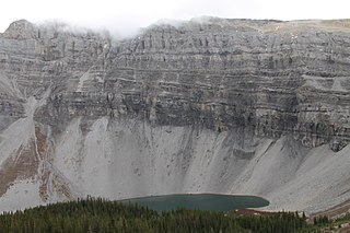
WHidden Lake is a small glacial lake in the Skoki Valley of Banff National Park, Canada. It is located in the Slate Range of the Canadian Rockies.
 W
WHowse Pass is a pass through the Rocky Mountains in Canada. The pass is located in Banff National Park, between Mount Conway and Howse Peak. From here waters flow east via Conway Creek, Howse River, North Saskatchewan River to Lake Winnipeg and Hudson Bay. To the west it drains by the Blaeberry River to the Columbia River and on to the Pacific Ocean.
 W
WThe Howse River is a tributary of the North Saskatchewan River in western Alberta, Canada.
 W
WImprovement District No. 9 (Banff), or Improvement District No. 9, is an improvement district in Alberta, Canada. Located within Banff National Park in Alberta's Rockies, the improvement district is the municipality that provides local government for the portion of the park outside the Town of Banff.
 W
WJohnston Creek is a tributary of the Bow River in Canada's Rocky Mountains. The creek is located in Banff National Park.
 W
WKicking Horse Pass is a high mountain pass across the Continental Divide of the Americas of the Canadian Rockies on the Alberta/British Columbia border, and lying within Yoho and Banff national parks. A National Historic Site of Canada, the pass is of historical significance because the main line of the Canadian Pacific Railway (CPR) was constructed between Lake Louise, Alberta and Field, British Columbia using this route in 1884, in preference to the originally planned route through the more northerly Yellowhead Pass.
 W
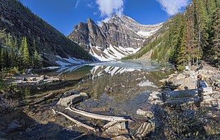
WLake Agnes is a small mountain lake in the Banff National Park of Alberta, Canada.
 W
WLake Louise is a glacial lake within Banff National Park in Alberta, Canada. It is located 5 km (3.1 mi) west of the Hamlet of Lake Louise and the Trans-Canada Highway.
 W
WThe Lake Louise Ski Resort & Summer Gondola is a ski resort in western Canada, located in Banff National Park near the village of Lake Louise, Alberta. Located 57 km (35 mi) west of Banff, Lake Louise is one of three major ski resorts within Banff National Park.
 W
WLake Louise is a hamlet within Banff National Park in Alberta, Canada. Named after Princess Louise, Duchess of Argyll, it lies in Alberta's Rockies on the Bow River, 3 km (1.9 mi) northeast of the lake that shares its name. Initially settled in 1884 as an outpost for the Canadian Pacific Railway, Lake Louise sits at an elevation of 1,600 m (5,200 ft), making it Canada's highest community. The nearby lake, framed by mountains, is one of the most famous mountain vistas in the world; the famous Chateau Lake Louise also overlooks the lake.
 W
WLake Minnewanka is a glacial lake located in the eastern area of Banff National Park in Canada, about five kilometres northeast of the Banff townsite. The lake is 21 km (13 mi) long and 142 m (466 ft) deep, making it the 2nd longest lake in the mountain parks of the Canadian Rockies.
 W
WMistaya Canyon is a canyon in the western part of the Alberta province of Canada. It is formed by the Mistaya River. Tourists who are visiting Banff National Park often visit it because of its distinctive curvy canyon walls and because it is easy to access, being just off the Icefields Parkway. The 0.5 km trail to the canyon is located at a large parking area on the west side of the Parkway, part way up the long hill south of the North Saskatchewan River. There are actually two such parking areas on the hill; the Mistaya one is clearly marked by signs on the highway and at the beginning of the trail. The trail is an easy walk in summer but too steep for wheelchairs. The canyon is deep and there are no railings. The trail is icy in early spring.
 W
WThe Mistaya River is a short river in western Alberta, Canada. It flows through the Canadian Rockies, and a section of the Icefields Parkway was built along its course.
 W
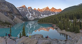
WMoraine Lake is a glacially fed lake in Banff National Park, 14 kilometres (8.7 mi) outside the Village of Lake Louise, Alberta, Canada. It is situated in the Valley of the Ten Peaks, at an elevation of approximately 1,884 metres (6,181 ft). The lake has a surface area of 50 hectares.
Mt. Norquay is a mountain and ski resort in Banff National Park, Canada that lies directly northwest of the Town of Banff. The regular ski season starts early December and ends mid-April. Mount Norquay is one of three major ski resorts located in the Banff National Park.
 W
WPanther Falls are a series of waterfalls in Banff National Park, Alberta, Canada. It is developed on Nigel Creek and its waters originate in Nigel Pass, between the slopes of Cirrus Mountain and Nigel Peak in the Parker Ridge of the Canadian Rockies.
 W
WThe Peyto Glacier is situated in the Canadian Rockies in Banff National Park, Alberta, Canada, approximately 90 km (56 mi) northwest of the town of Banff, and can be accessed from the Icefields Parkway. Peyto Glacier is an outflow glacier from the Wapta Icefield, which rests along the Continental divide. The glacier snout is subject to high melt rates from season to season and there is marked surface lowering on several parts of the glacier. Glacial silt, which is carried from the glacier by streams, ensures a turquoise appearance to Peyto Lake, a popular touring destination. As is true for the vast majority of glaciers worldwide, Peyto Glacier has been retreating rapidly, especially since the last half of the 20th century, and has reportedly lost 70% of its mass since it was first researched (Demuth and Keller, 2006). Between 1896 and 1966, the total volume loss of the Peyto Glacier was 1088.5 x 106 m3 (Wallace, 1995). In 1987, an automatic weather station was constructed near the glacier that monitors temperature changes, radiation and precipitation.
WPeyto Lake is a glacier-fed lake in Banff National Park in the Canadian Rockies. The lake itself is near the Icefields Parkway. It was named for Bill Peyto, an early trail guide and trapper in the Banff area.
 W
WPtarmigan Lake is an alpine lake at the foot of Ptarmigan Peak. Several backcountry campgrounds are situated near the lake, as well as the Skoki Ski Lodge just over Deception Pass. The main access to the lake is a trail near the Lake Louise Mountain Resort. The lake drains into the Bow River via the Skoki Valley.
 W
WPulsatilla Pass Is a pass located in Banff National Park. As the sources for both Johnston Creek, and Wildflower Creek it is located near the Sawback Range between Johnston Canyon and Lake Louise, Alberta.
 W
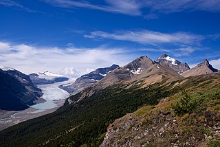
WThe Saskatchewan Glacier is located in Banff National Park, Alberta, Canada, approximately 120 km (75 mi) northwest of the town of Banff, and can be accessed from the Icefields Parkway. Saskatchewan Glacier is the largest outflow glacier from the Columbia Icefield, which rests along the Continental Divide. The glacier is a primary water source for the North Saskatchewan River. The glacier is approximately 13 kilometres (8.1 mi) long and covers an area of 30 km² (11.5 mi²) and was measured in 1960 to be over 400 metres (1,300 ft) thick at a distance of 8 kilometres (5.0 mi) from the terminal snout. Between the years 1893 and 1953, Saskatchewan Glacier had retreated a distance of 1,364 metres (4,475 ft), with the rate of retreat between the years 1948 and 1953 averaging 55 metres (180 ft) per year.
WSaskatchewan River Crossing is a locality in western Alberta, Canada. It is located within Banff National Park at the junction of Highway 93 and Highway 11. It is administered by Improvement District No. 9.
 W
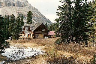
WThe Skoki Ski Lodge National Historic Site of Canada was built in 1930-31 in the Skoki Valley of Canada's Banff National Park. Built by local members of the Ski Club of the Canadian Rockies, the lodge was the first commercial building built specifically to serve skiers in Canada, and possibly in North America. Design and construction work was carried out by local outfitter and builder Earl Spencer with help from Spud White and Victor Kutschera. The lodge was progressively expanded through 1936 by outfitter, guide and log home builder Jim Boyce who was also managing the Lodge the time. It has remained unaltered since that time. The Lodge operates throughout the year.
 W
WThe Spray River is a tributary of the Bow River in western Alberta, Canada.
 W
WSulphur Mountain Cosmic Ray Station, a National Historic Site of Canada found atop Sulphur Mountain in Banff National Park, commemorates Canada's participation in the International Geophysical Year, during 1957 to 1958. Canada constructed nine sites to study cosmic rays, but this site in particular was the most important due to its higher elevation. The National Research Council constructed a laboratory at the site in the winter of 1956-57. The building was not visible from the Banff townsite as a condition of its construction.
 W
WSunwapta Pass is a mountain pass in the Canadian Rockies in the province of Alberta. Sunwapta Pass is the low point of the saddle created between Mount Athabasca and Nigel Peak. The pass marks the boundary between Banff and Jasper National Parks. The Icefields Parkway travels through Sunwapta Pass 108 km (67 mi) southeast of the town of Jasper and 122 km (76 mi) northwest of the Parkway's junction with the Trans-Canada Highway near Lake Louise. The pass is the second highest point on the Icefields Parkway. Bow Summit in Banff National Park is the highest point on the parkway.
 W
WTunnel Mountain, is a mountain located in the Bow River Valley of Banff National Park in Alberta, Canada at the junction of the Spray River with the Bow and over looking the Hot Springs on Sulphur Mountain. The mountain is nearly completely encircled by the town of Banff and the Banff Springs Hotel grounds. For many Indigenous people, the Buffalo is not sleeping anymore since Banff National Park reintroduced wild bison in 2017.
WValley of the Ten Peaks is a valley in Banff National Park in Alberta, Canada, which is crowned by ten notable peaks and also includes Moraine Lake. The valley can be reached by following the Moraine Lake road near Lake Louise. The ten peaks were originally named by Samuel Allen, an early explorer of the region, who simply referred to them by using the numerals from one to ten in the Stoney First Nations Language. He may have learned the terms from his Native American guides, who helped him with the horses. The Nakoda–also known as the Stoney Indians–is a tribe whose culture and dialect are closely related to that of the Assiniboine First Nation, from whom they are believed to have separated in the mid-1700s, and who roamed large parts of the prairies and mountains of western Alberta well into British Columbia. The secluded Valley of the Ten Peaks was part of their original homeland. Gradually, though, all but three of the mountains were renamed in honour of noteworthy individuals, including Allen himself.
 W
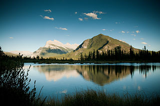
WThe Vermilion Lakes are a series of lakes located immediately west of Banff, Alberta, in the Canadian Rocky Mountains.
 W
WVermilion Pass is a high mountain pass in the Canadian Rockies, traversing the continental divide. It connects Kootenay National Park in the province of British Columbia with Banff National Park in Alberta.
 W
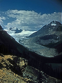
WThe Wapta Icefield is located on the Continental Divide in the Waputik Mountains of the Canadian Rockies, in the provinces of British Columbia and Alberta. The icefield is shared by Banff and Yoho National Parks and numerous outlet glaciers extend from the icefield, including the Vulture, Bow and Peyto Glaciers. Runoff from the icefields and outlet glaciers supply water to both the Kicking Horse and Bow Rivers, as well as numerous streams and lakes.
 W
WThe Waputik Icefield is located on the Continental divide in the Canadian Rocky Mountains, in the provinces of British Columbia and Alberta. It is developed on the heights of the Waputik Range in the Central Main Ranges.