 W
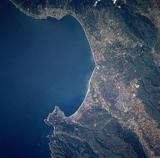
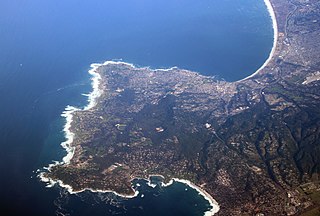
WMonterey Bay is a bay of the Pacific Ocean located on the coast of the U.S. state of California. The bay is south of the major cities of San Francisco and San Jose. Santa Cruz is located at the north end of the bay, and Monterey is on the Monterey Peninsula at the south end. The "Monterey Bay Area" is a local colloquialism sometimes used to describe the whole of the Central Coast communities of Santa Cruz and Monterey counties.
 W
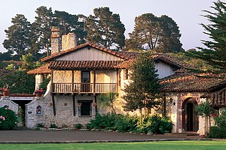
WAsilomar State Beach, officially Asilomar State Beach and Conference Grounds State Park, is a state park unit of California, USA. It provides public access to rocky coast and dune habitat on the Monterey Peninsula. The property includes the Asilomar Conference Grounds, a conference center built by the YWCA in 1913 that is now a National Historic Landmark. The 107-acre (43 ha) site is located in Pacific Grove and offers overnight lodging and views of the forest, surf and sand.
WAsilomar State Marine Reserve (SMR) is one of four small marine protected areas (MPAs) located near the cities of Monterey and Pacific Grove, at the southern end of Monterey Bay on California’s central coast. The four MPAs together encompass 2.96 square miles (7.7 km2). The SMR protects all marine life within its boundaries. Fishing and take of all living marine resources is prohibited.
WThe Association of Monterey Bay Area Governments (AMBAG) is a regional governmental organization which consists of representation of a large number of public agencies within Monterey County, Santa Cruz County and San Benito County, California. AMBAG has a broad charter of research and governmental oversight for a variety of functions including elements of land planning, natural resource conservation, energy, transportation, and economic development. The following governmental entities are members of AMBAG:
 W
WCalCOFI is a multi-agency partnership formed in 1949 to investigate the collapse of the sardine population off California. The organization's members are from NOAA Fisheries Service, Scripps Institution of Oceanography, and California Department of Fish and Wildlife. The scope of this research has evolved into the study of marine ecosystems off California and the management of its fisheries resources. In 2004, the CalCOFI survey area became one of 26 LTER research sites. This time-series of oceanographic and fisheries data allows scientists to assess the human impact and effects of climate change on the coastal ocean ecosystem. CalCOFI hydrographic & biological data, publications, and web information are distributed for use without restriction under the terms of the GNU Free Documentation License.
 W
WCannery Row is the waterfront street bordering the city of Pacific Grove, but officially in the New Monterey section of Monterey, California. It was the site of a number of now-defunct sardine canning factories. The last cannery closed in 1973. The street name, formerly a nickname for Ocean View Avenue, became official in January 1958 to honor John Steinbeck and his well-known novel Cannery Row. In the novel's opening sentence, Steinbeck described the street as "a poem, a stink, a grating noise, a quality of light, a tone, a habit, a nostalgia, a dream."
 W
WCarneros Creek is a westward flowing stream and is the primary source of freshwater flowing into Elkhorn Slough. The Carneros Creek official mainstem is 9.8 miles (15.8 km) long. Its source is in the northern Gabilan Range along Highway 101/156. After it waters transit Elkhorn Slough, the historic mouth of the Salinas River, Carneros Creek empties into Monterey Bay at Moss Landing, California.
 W
WThe David and Lucile Packard Foundation is a private foundation that provides grants to not-for-profit organizations. It was created in 1964 by David Packard and his wife Lucile Salter Packard. Following David Packard's death in 1996, the Foundation became the beneficiary of part of his estate. The foundation's goals, through the use of grants, are to "improve the lives of children, enable creative pursuit of science, advance reproductive health, and conserve and restore earth’s natural systems." As of 2016, The David and Lucile Packard Foundation was the 20th wealthiest foundation in the United States.
 W
WDavidson Seamount is a seamount located off the coast of Central California, 80 mi (129 km) southwest of Monterey and 75 mi (121 km) west of San Simeon. At 26 mi (42 km) long and 8 mi (13 km) wide, it is one of the largest known seamounts in the world. From base to crest, the seamount is 7,480 ft (2,280 m) tall, yet its summit is still 4,101 ft (1,250 m) below the sea surface. The seamount is biologically diverse, with 237 species and 27 types of deep-sea coral having been identified.
 W
WEdward F. Ricketts State Marine Conservation Area is one of four small marine protected areas located near the cities of Monterey and Pacific Grove, at the southern end of Monterey Bay on California’s central coast. The four areas together encompass 2.96 square miles (7.7 km2). Within SMCAs fishing and take of all living marine resources is prohibited except the recreational take of finfish by hook-and-line and the commercial take of giant and bull kelp under certain conditions.
 W
WElkhorn Slough is a 7-mile-long (11 km) tidal slough and estuary on Monterey Bay in Monterey County, California. The community of Moss Landing and the Moss Landing Power Plant are located at the mouth of the slough on the bay.
 W
WThe Elkhorn Slough National Estuarine Research Reserve is a nature reserve that is located at 1700 Elkhorn Road in Watsonville, California. The reserve encompasses the central shore of Monterey Bay and is approximately 100 miles (160 km) south of San Francisco, California. The Elkhorn Slough is established as a part of the National Oceanic and Atmospheric Administration and is being managed as the Elkhorn Slough Ecological Reserve through the California Department of Fish and Game.
WElkhorn Slough is a 7-mile-long (11 km) tidal slough and estuary on Monterey Bay in Monterey County, California. The community of Moss Landing and the Moss Landing Power Plant are located at the mouth of the slough on the bay.
 W
WFisherman's Wharf is a historic wharf in Monterey, California, United States. Used as an active wholesale fish market into the 1960s, the wharf eventually became a tourist attraction as commercial fishing tapered off in the area.
 W
WThe Hovden Cannery in Cannery Row, Monterey, California was among the oldest, largest canneries of the Pacific Sardine Fishery. In the first half of the 20th century, it marked one of the most lucrative national fisheries. It was a source for literary inspiration in the works of John Steinbeck.
WLovers Point State Marine Reserve (SMR) is one of four small marine protected areas located near the cities of Monterey and Pacific Grove, at the southern end of Monterey Bay on California’s central coast. The four MPAs together encompass 2.96 square miles (7.7 km2). The SMR protects all marine life within its boundaries. Fishing and take of all living marine resources is prohibited.
 W
WManresa State Beach is a state-protected beach on Monterey Bay near Watsonville in Santa Cruz County, California. Manresa State Beach has two different State owned and operated facilities associated with it: Manresa Main State Beach, and Manresa Uplands State Beach and Campground.
 W
WMarina State Beach is a protected beach on Monterey Bay, located in the city of Marina in Monterey County, California.
 W
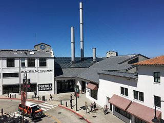
WMonterey Bay Aquarium is a nonprofit public aquarium in Monterey, California. Known for its regional focus on the marine habitats of Monterey Bay, it was the first to exhibit a living kelp forest when it opened in October 1984. Its biologists have pioneered the animal husbandry of jellyfish and it was the first to successfully care for and display a great white shark. The organization's research and conservation efforts also focus on sea otters, various birds, and tunas. Seafood Watch, a sustainable seafood advisory list published by the aquarium beginning in 1999, has influenced the discussion surrounding sustainable seafood.
 W
WThe Monterey Bay Aquarium Research Institute (MBARI) is a private, non-profit oceanographic research center in Moss Landing, California. MBARI was founded in 1987 by David Packard, and is primarily funded by the David and Lucile Packard Foundation. Christopher Scholin serves as the institute's president and chief executive officer, managing a work force of approximately 220 scientists, engineers, and operations and administrative staff.
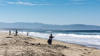
WMonterey Bay is a bay of the Pacific Ocean located on the coast of the U.S. state of California. The bay is south of the major cities of San Francisco and San Jose. Santa Cruz is located at the north end of the bay, and Monterey is on the Monterey Peninsula at the south end. The "Monterey Bay Area" is a local colloquialism sometimes used to describe the whole of the Central Coast communities of Santa Cruz and Monterey counties.
 W
WThe Monterey Bay National Marine Sanctuary (MBNMS) is a US Federally protected marine area offshore of California's Big Sur and central coast. It is the largest US national marine sanctuary and has a shoreline length of 276 miles (444 km) stretching from just north of the Golden Gate Bridge at San Francisco to Cambria in San Luis Obispo County. Supporting one of the world’s most diverse marine ecosystems, it is home to numerous mammals, seabirds, fishes, invertebrates and plants in a remarkably productive coastal environment. The MBNMS was established in 1992 for the purpose of resource protection, research, education, and public use.
 W
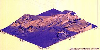
WMonterey Canyon, or Monterey Submarine Canyon, is a submarine canyon in Monterey Bay, California with steep canyon walls measuring a full 1 mile in height from bottom to top, which height/depth rivals the depth of the Grand Canyon itself. It is the largest such submarine canyon along the West coast of the North American continent, and was formed by the underwater erosion process known as turbidity current erosion. Many questions remain unresolved regarding the exact nature of its origins, and as such it is the subject of several ongoing geological and marine life studies being carried out by scientists stationed at the nearby Monterey Bay Aquarium Research Institute, the Moss Landing Marine Laboratories, and other oceanographic institutions.
 W
WThe Monterey Clipper is a fishing boat common to the San Francisco Bay Area, the Monterey Bay Area and east to the Sacramento delta.
 W
WThe Monterey Peninsula is located on the central California coast and comprises the cities of Monterey, Seaside, Carmel, Marina, and Pacific Grove, and unincorporated areas of Monterey County including the resort and community of Pebble Beach.
 W
WMonterey State Beach is a protected beach on southern Monterey Bay in Monterey County, California.
 W
WMonterey is a city located in Monterey County on the southern edge of Monterey Bay on California's Central Coast. Founded on June 3, 1770, it was the capital of Alta California under both Spain and Mexico. During this period, Monterey hosted California's first theater, public building, public library, publicly funded school, printing press, and newspaper. It was originally the only port of entry for all taxable goods in California. In 1846 during the Mexican–American War, the United States flag was raised over the Customs House. After California was ceded to the U.S. after the war, Monterey hosted California's first constitutional convention in 1849.
 W
WThe Moss Landing Marine Laboratories (MLML) is a multi-campus marine research consortium of the California State University System, headquartered at Moss Landing, California.
 W
WThe Moss Landing Power Plant is a natural gas powered electricity generation plant located in Moss Landing, California, United States, at the midpoint of Monterey Bay. Its large stacks are landmarks, visible throughout the Monterey Bay Area. The plant is owned and operated by Houston-based Dynegy and currently has a generation capacity of 1020 MW (net) from its two combined cycle generation units. It was once the largest power plant in the state of California, with a generation capacity of 2560 MW, before its two large supercritical steam units were taken offline.
 W
WMoss Landing State Beach is a state park on Monterey Bay, in Monterey County, California.
WMoss Landing Wildlife Area is a California State wildlife preserve on the shore of Elkhorn Slough.
WMoss Landing, formerly Moss, is a census-designated place (CDP) in Monterey County, California, United States. Moss Landing is located 15 miles (24 km) north-northeast of Monterey, at an elevation of 10 feet. It is located on the shore of Monterey Bay, at the mouth of Elkhorn Slough, and at the head of the submarine Monterey Canyon.
 W
WNatural Bridges State Beach is a 65-acre (26 ha) California state park in Santa Cruz, California in the United States. The park features a natural bridge across a section of the beach. It is also well known as a hotspot to see monarch butterfly migrations. The Monarch Butterfly Natural Preserve is home to up to 150,000 monarch butterflies from October through early February.
 W
WNew Brighton State Beach is a 95 acre beach park on Monterey Bay in Santa Cruz County, California, consisting of a beach and campgrounds. The park is located east of Santa Cruz in Capitola, on Park Avenue off of Highway 1. The park is adjacent to Seacliff State Beach, which is known for its fishing pier and sunk concrete freighter, The Palo Alto. The beach overlooks Soquel Cove and Monterey Bay.
 W
WPacific Biological Laboratories, abbreviated PBL, was a biological supply house that sold preserved animals and prepared specimen microscope slides, many of which were of maritime aquatic species, to schools, museums, and research institutions. It was located in a building on what is now Monterey's Cannery Row on Monterey Bay in Monterey County, California.
 W
WPacific Grove Marine Gardens State Marine Conservation Area is one of four small marine protected areas located near the cities of Monterey and Pacific Grove, at the southern end of Monterey Bay on California’s central coast. The four MPAs together encompass 2.96 square miles (7.7 km2). Within the SMCA fishing and take of all living marine resources is prohibited except the recreational take of finfish and the commercial take of giant and bull kelp by hand under certain conditions. According to the Frommer's guide, the Marine Gardens area is "renowned for ocean views, flowers, and tide-pool seaweed beds."
 W
WPacific Grove is a coastal city in Monterey County, California in the United States. The 2010 United States Census population is 15,041. Pacific Grove is located between Point Pinos and Monterey.
 W
WThe Pajaro River, is a U.S. river in the Central Coast region of California, forming part of the border between San Benito and Santa Clara Counties, the entire border between San Benito and Santa Cruz County, and the entire border between Santa Cruz and Monterey County. Flowing roughly east to west, the river empties into Monterey Bay, west of Watsonville, California.
 W
WThe Salinas River is the longest river of the Central Coast region of California, running 175 miles (282 km) and draining 4,160 square miles. It flows north-northwest and drains the Salinas Valley that slices through the central California Coast Ranges south of Monterey Bay. The river begins in southern San Luis Obispo County, originating in the Los Machos Hills of the Los Padres National Forest. From there, the river flows north into Monterey County, eventually making its way to connect with the Monterey Bay, part of the Pacific Ocean, approximately 5 miles south of Moss Landing. The river is a wildlife corridor, and provides the principal source of water from its reservoirs and tributaries for the farms and vineyards of the valley.
 W
WSalinas River National Wildlife Refuge is located approximately 11 miles north of Monterey, California, and 3 miles south of Castroville, California, at the point where the Salinas River empties into Monterey Bay. The 367-acre (1.49 km2) refuge encompasses several habitat types including sand dunes, pickleweed salt marsh, river lagoon, riverine habitat, and a saline pond. The refuge was established in 1974 because of its "particular value in carrying out the national migratory bird management program."
 W
WSalinas River State Beach is a beach at the river mouth of the Salinas River at Monterey Bay, in Monterey County, California.
 W
WThe San Benito River is a 109 miles (175 km) long river flowing northwesterly between the Diablo Range and the Gabilan Range, on the Central Coast of California. The river begins in southeasternmost San Benito County, California and ends in the extreme northwestern part of the county, where it is tributary to the Pajaro River. The San Benito River is longer than the Pajaro River and it drains more area, although it has proportionally lower flows.
 W
WThe San Gregorio Fault is an active, 209 km long fault located off the coast of Northern California. The southern end of the fault is in southern Monterey Bay, and the northern end is about 20 km northwest of San Francisco, near Bolinas Bay, where the San Gregorio intersects the San Andreas Fault. Most of the San Gregorio fault trace is located offshore beneath the waters of Monterey Bay, Half Moon Bay, and the Pacific Ocean, though it cuts across land near Point Año Nuevo and Pillar Point. The San Gregorio Fault is part of a system of coastal faults which run roughly parallel to the San Andreas. The movement of the San Gregorio is right-lateral strike-slip, and the slip rate is estimated to be 4 to 10 mm/year. The most recent major earthquake along the fault occurred some time between 1270-1775 AD, with an estimated magnitude of 7 to 7.25.
 W
WThe Santa Cruz Small Craft Harbor is situated in Santa Cruz, California, on the site of the former Woods Lagoon. Built in 1962–1963, its public use specializes in boating and extracurricular marine activities for the local community and visitors. The harbor straddles the city limits which runs down the center of Arana Gulch; the west side of the harbor is in Santa Cruz's Seabright neighborhood while the east is in unincorporated Santa Cruz County.
 W
WThe Santa Cruz long-toed salamander is an endangered subspecies of the long-toed salamander, which is found only close to a few isolated ponds in Santa Cruz and Monterey Counties in California. It has a black body, broken yellow or orange irregular striping along its spine, and a tail fin well evolved for swimming. Like other mole salamanders, it is found near pools or slow-moving streams and has a very secretive lifestyle, making it difficult to find.
 W
WSanta Cruz is the county seat and largest city of Santa Cruz County, California. As of 2019 the U.S. Census Bureau estimated Santa Cruz's population at 64,608.
 W
WThe Sardine Factory is a seafood restaurant in Monterey, California.
 W
WSeacliff State Beach is a state beach park on Monterey Bay, in the town of Aptos, Santa Cruz County, California. It is located off Highway 1 on State Park Drive, about 5 miles (8 km) south of Santa Cruz,. The beach is most known for the concrete ship SS Palo Alto lying in the water. North of Seacliff State Beach is New Brighton State Beach.
 W
WSeaside, formerly East Monterey, is a city in Monterey County, California, United States, with a population of 33,025 as of the 2010 census. Seaside is located 2.25 miles (3.6 km) east-northeast of Monterey, at an elevation of 33 feet (10 m), and is the home of California State University, Monterey Bay (CSUMB) and the Monterey College of Law, which are located on the site of the former military base Fort Ord. Also on the site are the Bayonet and Black Horse golf courses, now open to the public and host to PGA Tour events, including the 2012 PGA Professional National Championship. Seaside is also the gateway to the Fort Ord National Monument Park, created on April 20, 2012.
 W
WSoquel Canyon State Marine Conservation Area (SMCA) is an offshore marine protected area in Monterey Bay. Monterey Bay is on California’s central coast with the city of Monterey at its south end and the city of Santa Cruz at its north end. The SMCA covers 23.41 square miles (60.6 km2). Within the SMCA, fishing and taking of any living marine resources is prohibited except the commercial and recreational take of pelagic finfish.
 W
WSS Palo Alto was a concrete ship built as a tanker at the end of World War I. Completed too late to see war service, she was mothballed until 1929, when she was intentionally grounded off a Northern California beach, becoming part of a pleasure pier entertainment complex. Palo Alto was damaged by the sea, leading her to be stripped and used only as a fishing pier. Subsequent decades have seen her be further broken by the sea, but large sections of her wreck remain somewhat intact.
 W
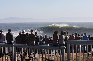
WSteamer Lane is a famous surfing location in Santa Cruz, California. It is just off a point on the side of cliffs in the West Cliff residential area near downtown Santa Cruz, providing easy access and a good vantage point for viewing. The Santa Cruz Surfing Museum is housed in a lighthouse there. "Steamer Lane" is the preferred form of the name used by the people surfing there. Steamer Lane was named by Claude Horan while he was a student at San Jose State in the late 1930s. One flat calm day he and his friend Wes Hammond thought it would be a good idea to hire steamships to cruise back and forth to generate waves for surfing. It was at Steamer Lane that the modern surfing wetsuit and the leash were mainly developed by Jack O'Neill, who had his surf shop nearby for many years.
 W
WSunset State Beach is a park and beach on Monterey Bay, in Santa Cruz County, California.
 W
WTwin Lakes State Beach is a beach located on Monterey Bay directly south of the Santa Cruz Yacht Harbor Santa Cruz, in coastal Santa Cruz County, northern California.