 W
WThe Altiplano–Puna volcanic complex, also known as APVC, is a complex of volcanic systems in the Puna of the Andes. It is located in the Altiplano area, a highland bounded by the Bolivian Cordillera Real in the east and by the main chain of the Andes, the Western Cordillera, in the west. It results from the subduction of the Nazca Plate beneath the South American Plate. Melts caused by subduction have generated the volcanoes of the Andean Volcanic Belt including the APVC. The volcanic province is located between 21° S–24° S latitude. The APVC spans the countries of Argentina, Bolivia and Chile.
 W
WThe Anahim Volcanic Belt is a 600 km (373 mi) long volcanic belt, stretching from just north of Vancouver Island to near Quesnel, British Columbia, Canada. The Anahim Volcanic Belt has had three main magmatic episodes: 15–13 Ma, 9–6 Ma, and 3–1 Ma. The volcanoes generally become younger eastward at a rate of 2 cm (0.8 in) to 3.3 cm (1.3 in) a year. The Nazko Cone, which last erupted only 7,200 years ago, is the youngest Anahim volcano. These volcanoes are thought to have formed as a result of the North American Plate sliding westward over a long-lived center of upwelling magma called the Anahim hotspot. The hotspot is thought to be similar to the one feeding the Hawaiian Islands.
 W
WAzas Plateau is a volcanic field in Russia. It is also known as East Tuva Plateau, Khamsara-Biykhem Plateau and Northeast Tuva Plateau. It covers a surface area of 2,000 square kilometres (770 sq mi) west of Lake Baikal. Volcanic activity in the area also occurred at the Oka Plateau and the Jom-Bolok volcanic field.
 W
WThe Big Lava Bed, located in the Gifford Pinchot National Forest in the southwestern area of the State of Washington, originated from a 500-foot-deep crater in the northern center of the bed. The Big Lava Bed is the youngest feature of the Indian Heaven volcanic field. The 0.9-cubic kilometer lava flow erupted from the cinder cone about 8200 years ago. The lava flow traveled 13 km from the source crater. Lodgepole pine, alder, and other pioneer plants struggle to grow, seen sparsely growing between and amid towering rock piles, caves, and strange lava formations. Access into the interior of the lava bed is difficult, since there are no roads or trails crossing the lava field. Explorers who wish to venture deep within the lava flow are advised to choose their route carefully. Compasses are not always reliable, since local magnetic influences affect their magnetic performance in the vast expanse of rock.
 W
WThe Bishop Tuff is a welded tuff that formed 767,100 ± 900 years ago as a rhyolitic pyroclastic flow during the eruption that created the Long Valley Caldera. Large outcrops of the tuff are located in Inyo and Mono Counties, California, United States.
 W
WThe Boring Lava Field is a Plio-Pleistocene volcanic field with cinder cones, small shield volcanoes, and lava flows in the northern Willamette Valley of the U.S. state of Oregon. Located 12 miles (19 km) southeast of downtown Portland, the field got its name from the town of Boring, Oregon, which lies just southeast of the most dense cluster of lava vents. The zone became active about 2.7 million years ago, with long periods of activity interspersed with quiescence. Its last eruptions took place about 57,000 years ago at the Beacon Rock cinder cone volcano; the individual volcanic vents of the field are considered extinct, but the field itself is not.
 W
WThe Campanian Ignimbrite eruption was a major volcanic eruption in the Mediterranean during the late Quaternary, classified at 7 on the Volcanic Explosivity Index (VEI). The event has been attributed to the Archiflegreo volcano, the 13-kilometre-wide (8.1 mi) caldera of the Phlegraean Fields, located 20 km (12 mi) west of Mount Vesuvius under the western outskirts of the city of Naples and the Gulf of Pozzuoli, Italy. Estimates of the date, magnitude and the amount of ejected material have varied considerably during several centuries of investigation. This applies to most significant volcanic events that originated in the Campanian Plain, as it is one of the most complex volcanic structures in the world. However, continued research, advancing methods and accumulation of volcanological, geochronological, and geochemical data has amounted to ever more precise dating.
 W
WThe Canadian Cascade Arc, also called the Canadian Cascades, is the Canadian segment of the North American Cascade Volcanic Arc. Located entirely within the Canadian province of British Columbia, it extends from the Cascade Mountains in the south to the Coast Mountains in the north. Specifically, the southern end of the Canadian Cascades begin at the Canada–United States border. However, the specific boundaries of the northern end are not precisely known and the geology in this part of the volcanic arc is poorly understood. It is widely accepted by geologists that the Canadian Cascade Arc extends through the Pacific Ranges of the Coast Mountains. However, others have expressed concern that the volcanic arc possibly extends further north into the Kitimat Ranges, another subdivision of the Coast Mountains, and even as far north as Haida Gwaii.
 W
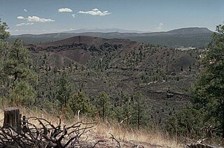
WCapulin Volcano National Monument is a U.S. National Monument located in northeastern New Mexico that protects and interprets an extinct cinder cone volcano and is part of the Raton-Clayton Volcanic Field. A paved road spirals gradually around the volcano and visitors can drive up to a parking lot at the rim of the extinct volcano. Hiking trails circle the rim as well as lead down into the mouth of the volcano. The monument was designated on August 9, 1916 and is administered by the National Park Service. The volcano is located 5 kilometres (3.1 mi) north of the village of Capulin.
 W
WThe Cascade Volcanoes are a number of volcanoes in a volcanic arc in western North America, extending from southwestern British Columbia through Washington and Oregon to Northern California, a distance of well over 700 miles (1,100 km). The arc formed due to subduction along the Cascadia subduction zone. Although taking its name from the Cascade Range, this term is a geologic grouping rather than a geographic one, and the Cascade Volcanoes extend north into the Coast Mountains, past the Fraser River which is the northward limit of the Cascade Range proper.
 W
WThe Chaîne des Puys is a north-south oriented chain of cinder cones, lava domes, and maars in the Massif Central of France. The chain is about 40 km (25 mi) long, and the identified volcanic features include 48 cinder cones, eight lava domes, and 15 maars and explosion craters. Its highest point is the lava dome of Puy de Dôme, located near the middle of the chain, which is 1,465 m (4,806 ft) high. The name of the range comes from a French term, puy, that refers to a volcanic mountain with a rounded profile. A date of 4040 BCE is usually given for the last eruption of a Chaîne des Puys volcano.
 W
WThe Cheakamus Valley basalts are a sequence of basaltic lava flows along the Cheakamus River in southwestern British Columbia, Canada. They are part of the Garibaldi section of the Cascade Volcanic Arc and were produced during an episode of volcanic eruptions from an unknown vent. The latest basaltic eruption deposited wood in lacustrine sediments under the lava flows that have been dated 34,200 ± 800 years old. These youngest lavas form isolated ridges above the older glaciated Cheakamus Valley basalts and were described as "esker-like" by Canadian volcanologist Bill Mathews.
 W
WThe Chilcotin Group, also called the Chilcotin Plateau Basalts, is a large area of basaltic lava that forms a volcanic plateau running parallel with the Garibaldi Volcanic Belt in south-central British Columbia, Canada.
 W
WThe Coso Range of eastern California is located immediately south of Owens Lake (dry), east of the Sierra Nevada, and west of the Argus Range. The southern part of the range lies in the restricted Naval Air Weapons Station China Lake and the northern part of the range is designated as the Coso Range Wilderness. The mountains include Coso Peak, at 8,160 feet (2,487 m) above sea level, as well as Silver Peak and Silver Mountain, both more than 7,400 ft (2,300 m) in height.
 W
WThe Devastator Assemblage is a geological formation comprising a portion of the Mount Meager massif in southwestern British Columbia, Canada. It is named after Devastator Peak, the lowest and southernmost subsidiary peak of Meager. The south and west flanks of Pylon Peak and Devastator Peak are made of The Devastator Assemblage rocks.
 W
WThe Garibaldi Lake volcanic field is a volcanic field, located in British Columbia, Canada. It was formed by a group of nine small andesitic stratovolcanoes and basaltic andesite vents in the scenic Garibaldi Lake area immediately north of Mount Garibaldi was formed during the late Pleistocene and early Holocene. The oldest stratovolcano, The Black Tusk, formed between about 1.3 and 1.1 million years ago (Ma). Following glacial dissection, renewed volcanism produced the lava dome and flow forming its summit. Other Pleistocene vents are located along and to the west of the Cheakamus River. Cinder Cone, to the east of The Black Tusk, produced a 9-km-long lava flow during the late Pleistocene or early Holocene.
 W
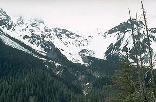
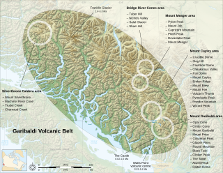
WThe Garibaldi Volcanic Belt is a northwest-southeast trending volcanic chain in the Pacific Ranges of the Coast Mountains that extends from Watts Point in the south to the Ha-Iltzuk Icefield in the north. This chain of volcanoes is located in southwestern British Columbia, Canada. It forms the northernmost segment of the Cascade Volcanic Arc, which includes Mount St. Helens and Mount Baker. Most volcanoes of the Garibaldi chain are dormant stratovolcanoes and subglacial volcanoes that have been eroded by glacial ice. Less common volcanic landforms include cinder cones, volcanic plugs, lava domes and calderas. These diverse formations were created by different styles of volcanic activity, including Peléan and Plinian eruptions.
 W
WHaruj is a large volcanic field spread across 42,000–45,000 km2 (16,000–17,000 sq mi) in central Libya. It is one of several volcanic fields in Libya along with Tibesti, and its origin has been attributed to the effects of geologic lineaments in the crust.
 W
WThe High Eifel forms part of the Eifel Mountains in the German state of Rhineland-Palatinate.
 W
WHollister Ridge is a group of seamounts in the Pacific Ocean. They lie west from the Pacific-Antarctic Ridge and form three ridges that form a line; one of the ridges rises to a depth of 100 metres (330 ft) and in the past formed an island. The seamounts are composed out of basaltic and other rocks and their ages range from about 2.5 million years ago to latest Pleistocene; an acoustic swarm recorded in the southern Pacific Ocean in 1991-1992 is considered to be the manifestation of a historical eruption of the Hollister Ridge.
 W
WThe Huckleberry Ridge Tuff is a tuff formation created by the Huckleberry Ridge eruption that formed the Island Park Caldera that lies partially in Yellowstone National Park, Wyoming and stretches westward into Idaho into a region known as Island Park. This eruption of 2,200 km3 (530 cu mi) of material is thought to be the largest known eruption in the Yellowstone Hotspot's history. This eruption, 2.1 million years ago, is the third most recent large caldera forming eruption from the Yellowstone hotspot. It was followed by the Mesa Falls Tuff and the Lava Creek Tuff eruptions.
 W
WThe Iceland Plateau or Icelandic Plateau is an oceanic plateau in the North Atlantic Ocean consisting of Iceland and its contiguous shelf and marginal slopes. It resides on an active rift zone of the Mid-Atlantic Ridge from which extensive tholeiitic plateau basalts and a number of large rhyolitic domes have been extruded.
 W
WIndian Heaven is a volcanic field in Skamania County in the state of Washington, in the United States. Midway between Mount St. Helens and Mount Adams, the field dates from the Pleistocene to the early Holocene epoch. It trends north to south and is dominated by six small shield volcanoes; these shields are topped by small spatter and cinder cones, and the field includes a number of subglacial volcanoes and tuyas. The northernmost peak in the field is Sawtooth Mountain and the southernmost is Red Mountain; its highest point is Lemei Rock at an elevation of 5,925 feet (1,806 m).
 W
WThe Jemez Mountains ([ˡhɛmɛz]) are a volcanic group of mountains in Rio Arriba, Sandoval, and Los Alamos counties, New Mexico, United States.
 W
WLa Palma, also San Miguel de La Palma, is the most north-westerly island of the Canary Islands, Spain. La Palma has an area of 708 square kilometres (273 sq mi) making it the fifth largest of the seven main Canary Islands. The total population at the start of 2019 was 82,671, of which 15,716 lived in the capital, Santa Cruz de la Palma and about 20,467 in Los Llanos de Aridane. La Palma has "sister city" status with El Dorado Hills, California. Its highest mountain is the Roque de los Muchachos, at 2,423 metres (7,949 ft), being second among the peaks of the Canaries only to the peaks of the Teide massif on Tenerife.
 W
WLake Poco Sol, Laguna Poco Sol or Laguna Pocosol, is a volcanic lake in Costa Rica, in the Cordillera de Tilarán.
 W
WThe Lava Creek Tuff is a tuff formation in Wyoming, Montana and Idaho, United States, created during the Lava Creek eruption around 630,000 years ago, which formed the Yellowstone Caldera.
 W
WLos Frailes is an ignimbrite plateau in Bolivia, between the city of Potosi and the Lake Poopo. It belongs to a group of ignimbrites that exist in the Central Andes and which includes the Altiplano–Puna volcanic complex. The plateau covers a surface of 7,500 square kilometres (2,900 sq mi)–8,500 square kilometres (3,300 sq mi) with about 2,000 cubic kilometres (480 cu mi) of ignimbrite.
WThe Mosaic Assemblage is a rock unit of the Pacific Ranges of the Coast Mountains in southwestern British Columbia, Canada. It is the namesake of Mosaic Glacier, which is drained by Mosaic Creek. This geological formation formed 140,000 to less than 90,000 years ago when porphyritic plagioclase-augite-olivine basalt and trachybasalt was erupted in valleys and on mountain ridges. These volcanic rocks form scoriaceous lava flows, breccias, volcanic bombs and pillow lavas.
 W
WThe Mount Cayley volcanic field is a remote volcanic zone on the South Coast of British Columbia, Canada, stretching 31 km (19 mi) from the Pemberton Icefield to the Squamish River. It forms a segment of the Garibaldi Volcanic Belt, the Canadian portion of the Cascade Volcanic Arc, which extends from Northern California to southwestern British Columbia. Most of the Cayley volcanoes were formed during periods of volcanism under sheets of glacial ice throughout the last glacial period. These subglacial eruptions formed steep, flat-topped volcanoes and subglacial lava domes, most of which have been entirely exposed by deglaciation. However, at least two volcanoes predate the last glacial period and both are highly eroded. The field gets its name from Mount Cayley, the largest and most persistent volcano, located at the southern end of the Powder Mountain Icefield. This icefield covers much of the central portion of the volcanic field and is one of the several glacial fields in the Pacific Ranges of the Coast Mountains.
 W
WThe Northern Cordilleran Volcanic Province (NCVP), formerly known as the Stikine Volcanic Belt, is a geologic province defined by the occurrence of Miocene to Holocene volcanoes in the Pacific Northwest of North America. This belt of volcanoes extends roughly north-northwest from northwestern British Columbia and the Alaska Panhandle through Yukon to the Southeast Fairbanks Census Area of far eastern Alaska, in a corridor hundreds of kilometres wide. It is the most recently defined volcanic province in the Western Cordillera. It has formed due to extensional cracking of the North American continent—similar to other on-land extensional volcanic zones, including the Basin and Range Province and the East African Rift. Although taking its name from the Western Cordillera, this term is a geologic grouping rather than a geographic one. The southmost part of the NCVP has more, and larger, volcanoes than does the rest of the NCVP; further north it is less clearly delineated, describing a large arch that sways westward through central Yukon.
 W
WThe Oruanui eruption of New Zealand's Taupo Volcano, the world's most recent supereruption, had a Volcanic Explosivity Index of 8. It is one of the largest eruptions in the history of New Zealand. It occurred about 26,500 years ago in the Late Pleistocene and generated approximately 430 km3 (100 cu mi) of pyroclastic fall deposits, 320 km3 (77 cu mi) of pyroclastic density current (PDC) deposits and 420 km3 (100 cu mi) of primary intracaldera material, equivalent to 530 km3 (130 cu mi) of magma, totaling 1,170 km3 (280 cu mi) of total deposits. The eruption is divided into 10 different phases on the basis of nine mappable fall units and a tenth, poorly preserved but volumetrically dominant fall unit.
 W
WThe Plinth Assemblage, also known as the Plinth Formation, is an accreted terrane of igneous rocks in southwestern British Columbia, Canada, located just north of the Lillooet River and on the northern flank of the Mount Meager massif. It is named after Plinth Peak, a peak made of Plinth Assemblage rocks.
 W
WCerro Porquesa is an approximately 4,600 metres (15,100 ft) high rhyodacite lava dome in the Andes. The lava dome is of Pliocene/Pleistocene age with little glacial features on the younger domes indicating young ages.
 W
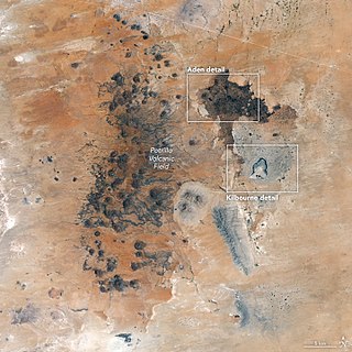
WThe Potrillo volcanic field is a monogenetic volcanic field located on the Rio Grande Rift in southern New Mexico, United States and northern Chihuahua, Mexico. The volcanic field lies 22 miles (35 km) southwest of Las Cruces, and occupies about 4,600 square kilometers (1,800 sq mi) near the U.S. border with Mexico.
 W
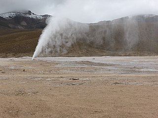
WPuchuldiza is a geothermal field in the Tarapacá Region of Chile. It is part of the Central Volcanic Zone of the Andes, close to the active volcano Isluga and several older volcanoes in the neighbourhood; the most recent activity from one of the neighbouring volcanoes was 900,000 ± 300,000 years ago. Geothermal features include geysers and hot springs. Puchuldiza has been inspected for the possibility that it may be suitable as a source for geothermal energy.
WThe Raton-Clayton volcanic field is a volcanic field located in the state of New Mexico, United States. Capulin Volcano National Monument is located in the volcanic field. It is the northeasternmost volcanic field of the Jemez Lineament and the easternmost Cenozoic volcanic field of North America.
 W
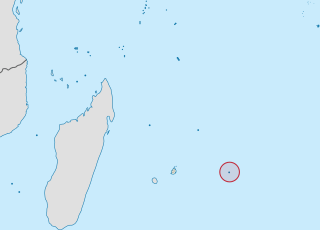
WRodrigues is a 108-square-kilometre (42 sq mi) autonomous outer island of the Republic of Mauritius in the Indian Ocean, about 560 kilometres (350 mi) east of Mauritius. It is part of the Mascarene Islands which include Mauritius and Réunion. It is of volcanic origin and is surrounded by coral reef, and just off its coast lie some tiny uninhabited islands. The island used to be the tenth District of Mauritius; it gained autonomous status on 10 December 2002, and it is governed by the Rodrigues Regional Assembly. The capital of the island is Port Mathurin.
 W
WThe Satah Mountain volcanic field (SMVF) is an extensive north-south trending volcanic chain in the Central Interior of British Columbia that stretches south of the Itcha Range shield volcano to northeast of Nimpo Lake. The chain is located on the Chilcotin Plateau, a major subdivision of the Interior Plateau that includes other nearby volcanic features. It forms a segment of the east-west trending Anahim Volcanic Belt, whose volcanic activity ranges in age from Miocene-to-Holocene. Volcanic features in the Satah Mountain field include lava domes, cinder cones and lava flows. Its name originates from Satah Mountain, the highest volcano, located 35 km (22 mi) northeast of Nimpo Lake.
 W
WSillajhuay is a volcano on the border between Bolivia and Chile. It is part of a volcanic chain that stretches across the border between Bolivia and Chile and forms a mountain massif that is in part covered by ice; whether this ice should be considered a glacier is debatable but it has been retreating in recent decades.
 W
WThe Snake River Plain is a geologic feature located primarily within the U.S. state of Idaho. It stretches about 400 miles (640 km) westward from northwest of the state of Wyoming to the Idaho-Oregon border. The plain is a wide, flat bow-shaped depression and covers about a quarter of Idaho. Three major volcanic buttes dot the plain east of Arco, the largest being Big Southern Butte.
 W
WThe Squamish volcanic field is a small north-south trending volcanic field on the South Coast of British Columbia, Canada. It extends for only about 3 km (1.9 mi) from the eastern side of Howe Sound northeast of Britannia Beach to the heavily forested slope on the western side of the Squamish River mouth. It forms the southernmost end of the Garibaldi Volcanic Belt, which comprises part of the Canadian Cascade Arc. Its volcanoes are relatively minor to the more voluminous stratovolcanoes found throughout the Garibaldi Belt and are composed of dacite and lesser basaltic andesite. The field gets its name from the nearby community of Squamish at the north end of Howe Sound on the Sea to Sky Highway.
 W
WSt. George is a city in and the county seat of Washington County, Utah, United States. Located in the southwestern corner of the state on the Arizona border, near the tri-state junction of Utah, Arizona and Nevada, it is the principal city of the St. George Metropolitan Statistical Area. The city lies in the northeasternmost part of the Mojave Desert, adjacent to the Pine Valley Mountains and near the convergence of three distinct geological areas: the Mojave Desert, Colorado Plateau, and Great Basin. The city is 118 miles (190 km) northeast of Las Vegas and 300 miles (480 km) south-southwest of Salt Lake City on Interstate 15.
 W
WSteamboat Springs is a small volcanic field of rhyolitic lava domes and flows in western Nevada, located south of Reno. There is extensive geothermal activity in the area, including numerous hot springs, steam vents, and fumaroles. The residential portions of this area, located mostly east of Steamboat Creek and south of modern-day SR 341, are now known simply as Steamboat.
 W
WTaryatu-Chulutu is a volcanic field in Mongolia. It is part of a volcanic area in Central Asia in the Hangai range that may be linked to the rifting of the Lake Baikal Rift. The field itself is located within the valleys of the Chuluut and Suman rivers. Volcanic activity occurred in the Miocene, Pliocene, Pleistocene and Holocene. The Khorgo cinder cone erupted during the Holocene and lava flows from it formed a lava dam generating Terkhiin Tsagaan Nuur lake.
 W
WTenerife is the largest and most-populated island of the eight Canary Islands. It is also the most-populated island of Spain, with a land area of 2,034.38 square kilometres (785.48 sq mi) and 917,841 inhabitants at the start of 2019, 43 percent of the total population of the Canary Islands. Tenerife is the largest and most-populous island of Macaronesia.
 W
WThis timeline of volcanism on Earth includes a list of major volcanic eruptions of approximately at least magnitude 6 on the Volcanic Explosivity Index (VEI) or equivalent sulfur dioxide emission during the Quaternary period. Other volcanic eruptions are also listed.
 W
WThe Youngest Toba eruption was a supervolcanic eruption that occurred around 75,000 years ago at the site of present-day Lake Toba in Sumatra, Indonesia. It is one of the Earth's largest known explosive eruptions. The Toba catastrophe theory holds that this event caused a global volcanic winter of six to ten years and possibly a 1,000-year-long cooling episode.
 W
WThe Tuya Range is a mountain range in the Stikine Ranges of the Cassiar Mountains in the far north of the Canadian province of British Columbia, near its border with the Yukon Territory and to the southwest of Watson Lake, Yukon, which is the nearest major settlement.
 W
WThe Udokan Plateau is a volcanic field in Transbaikalia, Russia. It covers a surface area of 3,000 square kilometres (1,200 sq mi) northeast of Lake Baikal in North Asia. Volcanism in the Udokan Plateau included both basaltic lava flows and later individual volcanic cones. Volcanism commenced in the Miocene and continued on into the Holocene.
 W
WThe Uinkaret volcanic field is an area of monogenetic volcanoes in northwestern Arizona, United States, located on the north rim of the Grand Canyon.
 W
WThe Volcanic Eifel or Vulkan Eifel is a region in the Eifel Mountains in Germany that is defined to a large extent by its volcanic geological history. Characteristic of this volcanic field are its typical explosion crater lakes or maars, and numerous other signs of volcanic activity such as volcanic tuffs, lava streams and volcanic craters like the Laacher See. The Volcanic Eifel is still volcanically active today. One sign of this activity is the escaping gases in the Laacher See.
 W
WThe Yellowstone hotspot is a volcanic hotspot in the United States responsible for large scale volcanism in Idaho, Montana, Nevada, Oregon, and Wyoming as the North American tectonic plate moved over it. It formed the eastern Snake River Plain through a succession of caldera-forming eruptions. The resulting calderas include the Island Park Caldera, the Henry's Fork Caldera, and the Bruneau-Jarbidge caldera. The hotspot currently lies under the Yellowstone Caldera. The hotspot's most recent caldera-forming supereruption, known as the Lava Creek eruption, took place 640,000 years ago and created the Lava Creek Tuff, and the most recent Yellowstone Caldera. The Yellowstone hotspot is one of a few volcanic hotspots underlying the North American tectonic plate; another example is the Anahim hotspot.
 W
WZuni-Bandera volcanic field is a volcanic field located in the state of New Mexico, United States.