 W
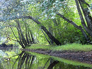
WThe Adirondack Park is a part of New York's Forest Preserve in northeastern New York, United States. The park was established in 1892 for “the free use of all the people for their health and pleasure”, for watershed protection, and as a future timber supply. The park's boundary roughly corresponds with the Adirondack Mountains. Unlike most state parks, about 52 percent of the land is privately owned inholdings. State lands within the park are known as Forest Preserve. Land use on public and private lands in the park are regulated by the Adirondack Park Agency. This area contains 102 towns and villages, as well as numerous farms, businesses, and an active timber-harvesting industry. The year-round population is 132,000, with 200,000 seasonal residents. The inclusion of human communities makes the park one of the great experiments in conservation in the industrialized world. The Forest Preserve was designated a National Historic Landmark in 1963.
 W
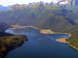
WAdmiralty Island National Monument is a United States National Monument located on Admiralty Island in Southeast Alaska, and is managed as part of the Tongass National Forest. It was created December 1, 1978, and covers 955,747 acres (3,868 km2) in Southeast Alaska. The remoteness of the monument led Congress to pass legislation designating all but 18,351 acres (74 km2) of the monument as the Kootznoowoo Wilderness, ensuring that the vast bulk of this monument is permanently protected from development. The monument is administered by the U.S. Forest Service from offices in Juneau.
 W
WThe Aleutian Islands, also called the Aleut Islands or Aleutic Islands and known before 1867 as the Catherine Archipelago, are a chain of 14 large volcanic islands and 55 smaller islands. Most of the Aleutian Islands belong to the U.S. state of Alaska, but some belong to the Russian federal subject of Kamchatka Krai. They form part of the Aleutian Arc in the Northern Pacific Ocean, occupying an area of 6,821 sq mi (17,666 km2) and extending about 1,200 mi (1,900 km) westward from the Alaska Peninsula toward the Kamchatka Peninsula in Russia, and mark a dividing line between the Bering Sea to the north and the Pacific Ocean to the south. Crossing longitude 180°, at which point east and west longitude end, the archipelago contains both the westernmost part of the United States by longitude and the easternmost by longitude. The westernmost U.S. island in real terms, however, is Attu Island, west of which runs the International Date Line. While nearly all the archipelago is part of Alaska and is usually considered as being in the "Alaskan Bush", at the extreme western end, the small, geologically related Commander Islands belong to Russia.
WThe Aleutian Islands, also called the Aleut Islands or Aleutic Islands and known before 1867 as the Catherine Archipelago, are a chain of 14 large volcanic islands and 55 smaller islands. Most of the Aleutian Islands belong to the U.S. state of Alaska, but some belong to the Russian federal subject of Kamchatka Krai. They form part of the Aleutian Arc in the Northern Pacific Ocean, occupying an area of 6,821 sq mi (17,666 km2) and extending about 1,200 mi (1,900 km) westward from the Alaska Peninsula toward the Kamchatka Peninsula in Russia, and mark a dividing line between the Bering Sea to the north and the Pacific Ocean to the south. Crossing longitude 180°, at which point east and west longitude end, the archipelago contains both the westernmost part of the United States by longitude and the easternmost by longitude. The westernmost U.S. island in real terms, however, is Attu Island, west of which runs the International Date Line. While nearly all the archipelago is part of Alaska and is usually considered as being in the "Alaskan Bush", at the extreme western end, the small, geologically related Commander Islands belong to Russia.
 W
WApalachicola Bay is an estuary and lagoon located on the northwest coast of the U.S. state of Florida. The Apalachicola Bay system also includes St. George Sound, St. Vincent Sound and East Bay, covering an area of about 208 square miles (540 km2). Four islands, St. Vincent Island to the west, Cape St. George Island and St. George Island to the south, and Dog Island to the east, separate the system from the Gulf of Mexico. Water exchange occurs through Indian Pass, West Pass, East Pass and the Duer Channel. The lagoon has been designated as a National Estuarine Research Reserve and the Apalachicola River is the largest source of freshwater to the estuary. Combined with the Chattahoochee River, Flint River, and Ochlockonee River they drain a watershed of over 20,000 square miles (50,000 km2) at a rate of 19,599 cubic feet (550 m3) per second according to the United States Geological Survey in 2002.
 W
WBig Bend National Park is an American national park located in West Texas, bordering Mexico. The park has national significance as the largest protected area of Chihuahuan Desert topography and ecology in the United States, and was named after a large bend in the Rio Grande/Río Bravo. The park protects more than 1,200 species of plants, more than 450 species of birds, 56 species of reptiles, and 75 species of mammals. Additional park activities include scenic drives, programs led by Big Bend park rangers, and stargazing.
 W
WThe Big Thicket is the name given to a somewhat imprecise region of a heavily forested area in Southeast Texas in the United States. It is a highly biodiverse area for a temperate region, that has been described as "America's Ark" and the "Biological Crossroads of North America". The National Park Service established the Big Thicket National Preserve (BTNP) within the region in 1974 and it is recognized as a biosphere reserve by UNESCO. Although the diversity of animals in the area is high, with over 500 vertebrates, it is the complex mosaic of ecosystems and plant diversity that is particularly remarkable. Biologists have identified at least eight, and up to eleven, ecosystems in the Big Thicket area. More than 160 species of trees and shrubs, 800 herbs and vines, and 340 types of grasses are known to occur in the Big Thicket, and estimates as high as over 1000 flowering plant species and 200 trees and shrubs have been made, plus ferns, carnivorous plants, and more. The Big Thicket has historically been the most dense forest region in what is now Texas.
 W
WThe Coast Ranges of California span 400 miles (644 km) from Del Norte or Humboldt County, California, south to Santa Barbara County. The other three coastal California mountain ranges are the Transverse Ranges, Peninsular Ranges and the Klamath Mountains.
 W
WThe California Coast Ranges Biosphere Reserve was a UNESCO Biosphere reserve located along the California Coast Ranges of northern California and the San Francisco Bay area until June 2017. This biosphere reserve includes a highly diverse complex of evergreen sclerophyllous woodland, coastal, estuary and marine ecosystems.
 W
WCape Lookout National Seashore preserves a 56-mile (90-km) long section of the Southern Outer Banks, or Crystal Coast, of North Carolina, USA, running from Ocracoke Inlet on the northeast to Beaufort Inlet on the southeast. Three undeveloped barrier islands make up the seashore - North and South Core Banks and Shackleford Banks. The seashore includes two historic villages on Core Banks, Shackleford's wild horses, and the Cape Lookout Lighthouse, which has a black-and-white diamond pattern. A visitors center for the seashore is located on Harkers Island.
 W
WThe Cape Romain National Wildlife Refuge is a 66,287 acre (267 km²) National Wildlife Refuge in southeastern South Carolina near Awendaw, South Carolina. The refuge lands and waters encompass water impoundments, creeks and bays, emergent salt marsh and barrier islands. 29,000 acres (120 km2) are designated as Class I Wilderness. Most of the refuge is only accessible by boat. Mainland facilities include the refuge's headquarters and visitor center which are located on U.S. Highway 17 about 30 minutes by car from Charleston, South Carolina.
 W
WCascade Head is a headland and 270-acre (110 ha) UNESCO biosphere reserve and United States Forest Service Experimental Forest. It is situated 85 miles (137 km) southwest of Portland, Oregon on the Oregon Coast between Lincoln City and Neskowin. Cascade Head Preserve is a Nature Conservancy Selected Site.
 W
WThe Central Plains Biosphere Reserve was a UNESCO Biosphere Reserve located in the western central Great Plains in north-central Colorado in the shortgrass prairie. The 6,210 hectares (24.0 sq mi) reserve encompasses the Central Plains Experimental Range (CPER) administered by the United States Department of Agriculture's Agricultural Research Service.
 W
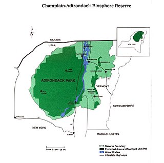
WThe Champlain-Adirondack Biosphere Reserve is a UNESCO-designated biosphere reserve.
 W
WChannel Islands National Park consists of five of the eight Channel Islands off the Pacific coast of the U.S. state of California. Although the islands are close to the shore of the densely populated state, they have been relatively undeveloped. The park covers 249,561 acres (100,994 ha), of which 79,019 acres (31,978 ha) are federal land. The Nature Conservancy owns and manages 76% of Santa Cruz Island, the largest of the eight.
 W
WThe Channel Islands are an eight-island archipelago located within the Southern California Bight in the Pacific Ocean, off the coast of California. The four Northern Channel Islands are part of the Transverse Ranges geologic province, and the four Southern Channel Islands are part of the Peninsular Ranges province. Five of the islands are within the Channel Islands National Park, and the waters surrounding these islands make up Channel Islands National Marine Sanctuary. The islands were first colonized as early as 13,000 years ago, the earliest paleontological evidence of humans in North America. They are the easternmost islands in the Pacific Island group.
 W
WDenali National Park and Preserve, formerly known as Mount McKinley National Park, is an American national park and preserve located in Interior Alaska, centered on Denali, the highest mountain in North America. The park and contiguous preserve encompass 6,045,153 acres which is larger than the state of New Hampshire. On December 2, 1980, 2,146,580-acre Denali Wilderness was established within the park. Denali's landscape is a mix of forest at the lowest elevations, including deciduous taiga, with tundra at middle elevations, and glaciers, snow, and bare rock at the highest elevations. The longest glacier is the Kahiltna Glacier. Wintertime activities include dog sledding, cross-country skiing, and snowmobiling. The park received 594,660 recreational visitors in 2018.
 W
WThe Desert Biosphere Reserve and Experimental Range is a biosphere reserve and experimental range in western Millard County, Utah, United States, that is listed as a historic district on the National Register of Historic Places.
 W
WDry Tortugas National Park is a national park in the United States about 68 miles (109 km) west of Key West in the Gulf of Mexico. The park preserves Fort Jefferson and the seven Dry Tortugas islands, the westernmost and most isolated of the Florida Keys. The archipelago's coral reefs are the least disturbed of the Florida Keys reefs.
 W
WEl Yunque National Forest, formerly known as the Caribbean National Forest, is a forest located in northeastern Puerto Rico. It is the only tropical rainforest in the United States National Forest System and the United States Forest Service.
 W
WThe Everglades & Dry Tortugas Biosphere Reserve is a UNESCO Biosphere Reserve in Florida and the Gulf of Mexico. The 636,411 hectares (2,457.20 sq mi) reserve encompasses Everglades National Park and Dry Tortugas National Park, including historic Fort Jefferson and the seven Dry Tortugas islands.
 W
WEverglades National Park is an American national park that protects the southern twenty percent of the original Everglades in Florida. The park is the largest tropical wilderness in the United States, and the largest wilderness of any kind east of the Mississippi River. An average of one million people visit the park each year. Everglades is the third-largest national park in the contiguous United States after Death Valley and Yellowstone. UNESCO declared the Everglades & Dry Tortugas Biosphere Reserve in 1976, and listed the park as a World Heritage Site in 1979, while the Ramsar Convention included the park on its list of Wetlands of International Importance in 1987. Everglades is one of only three locations in the world to appear on all three lists.
 W
WThe Fraser Biosphere Reserve and Experimental Forest is a former UNESCO Biosphere Reserve situated on the west side of the Continental Divide in north-central Colorado and includes the entire watershed of Main St. Louis Creek, a tributary of the Fraser River.
 W
WGlacier Bay National Park and Preserve is an American national park located in Southeast Alaska west of Juneau. President Calvin Coolidge proclaimed the area around Glacier Bay a national monument under the Antiquities Act on February 25, 1925. Subsequent to an expansion of the monument by President Jimmy Carter in 1978, the Alaska National Interest Lands Conservation Act (ANILCA) enlarged the national monument by 523,000 acres on December 2, 1980, and created Glacier Bay National Park and Preserve. The national preserve encompasses 58,406 acres of public land to the immediate northwest of the park, protecting a portion of the Alsek River with its fish and wildlife habitats, while allowing sport hunting.
 W
WGlacier National Park is an American national park located in northwestern Montana, on the Canada–United States border, adjacent to the Canadian provinces of Alberta and British Columbia. The park encompasses over 1 million acres (4,000 km2) and includes parts of two mountain ranges, over 130 named lakes, more than 1,000 different species of plants, and hundreds of species of animals. This vast pristine ecosystem is the centerpiece of what has been referred to as the "Crown of the Continent Ecosystem," a region of protected land encompassing 16,000 square miles (41,000 km2).
 W
WThe Golden Gate Biosphere is a biosphere reserve in Northern California. It was created by UNESCO in 1988 and encompasses 13 protected areas in the San Francisco Bay Area. It extends through the central California coastal region from the Bodega Marine Reserve in the north to Jasper Ridge in the south and includes the Farallon Islands, Angel Island, and Alcatraz within the San Francisco Bay. The biosphere reserve is situated on both sides of the San Andreas Fault. Each side has a completely different type of bedrock, and the western side of the rift is moving northward. It encompasses a diverse range of marine, coastal, and upland habitats of the California chaparral and woodlands and Northern California coastal forests ecoregions, including mixed evergreen forests, Coast Redwood forests, Douglas-fir forests, Bishop pine forests, oak forests, woodlands and savannas, northern coastal scrub, chaparral, coastal dune, coastal strand, tidepools, kelp forests, coastal grasslands, and marshes. The associated fauna is also rich with cougars, Tule elk, California sea lions, elephant seals, and many shorebirds.
 W
WGreat Smoky Mountains National Park is an American national park in the southeastern United States, with parts in Tennessee and North Carolina. The park straddles the ridgeline of the Great Smoky Mountains, part of the Blue Ridge Mountains, which are a division of the larger Appalachian Mountain chain. The park contains some of the highest mountains in eastern North America, including Clingmans Dome, Mount Guyot, and Mount Le Conte. The border between the two states runs northeast to southwest through the center of the park. The Appalachian Trail passes through the center of the park on its route from Georgia to Maine. With 12.5 million visitors in 2019, the Great Smoky Mountains National Park is the most visited national park in the United States.
 W
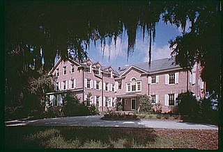
WHobcaw Barony is a 16,000 acres (6,475 ha) tract on a peninsula called Waccamaw Neck between the Winyah Bay and the Atlantic Ocean in Georgetown County, South Carolina. Much of Hobcaw Barony is south of US Highway 17. The land was purchased by the investor, philanthropist, presidential advisor, and South Carolina native Bernard M. Baruch between 1905 and 1907 for a winter hunting retreat. Later, his eldest child, Belle W. Baruch, began purchasing the property from her father beginning in 1936. By 1956, Belle owned Hobcaw Barony entirely. Upon her death in 1964, the property was transferred to the Belle W. Baruch Foundation for a nature and research preserve. The property includes more than 37 historic buildings and structures representative of the eras of both 18th & 19th century rice cultivation and 20th century winter retreats. Hobcaw Barony was named to the National Register of Historic Places on November 2, 1994.
 W
WHubbard Brook Experimental Forest is an area of land in the towns of Woodstock and Thornton in the White Mountains of New Hampshire that functions as an outdoor laboratory for ecological studies. It was initially established in 1955 by the United States Forest Service for the study of the relationship between forest cover and water quality and supply.
 W
WIsle Royale National Park is an American national park consisting of Isle Royale and hundreds of adjacent islands, as well as the surrounding waters of Lake Superior, in the state of Michigan. Isle Royale National Park was established on April 3, 1940, then additionally protected from development by wilderness area designation in 1976, and declared a UNESCO International Biosphere Reserve in 1980. The park covers 894 square miles (2,320 km2), with 209 square miles (540 km2) of land and 685 square miles (1,770 km2) of surrounding waters. The park's northern boundary lies adjacent to the Canadian Lake Superior National Marine Conservation Area along the international border.
 W
WThe Jornada Biosphere Reserve is a UNESCO Biosphere Reserve in southern New Mexico. It is one of three biosphere reserves representing the Chihuahuan Desert. The area extends from the crest of the San Andres Mountains, which are dominated by shrub woodlands, to the Jornada Plains characterized by semi-desert grasslands.
 W
WKings Canyon National Park is an American national park in the southern Sierra Nevada, in Fresno and Tulare Counties, California. Originally established in 1890 as General Grant National Park, the park was greatly expanded and renamed to Kings Canyon National Park on March 4, 1940. The park's namesake, Kings Canyon, is a rugged glacier-carved valley more than a mile (1,600 m) deep. Other natural features include multiple 14,000-foot (4,300 m) peaks, high mountain meadows, swift-flowing rivers, and some of the world's largest stands of giant sequoia trees. Kings Canyon is north of and contiguous with Sequoia National Park, and both parks are jointly administered by the National Park Service as the Sequoia and Kings Canyon National Parks.
 W
WThe Konza Prairie Biological Station is a 3,487-hectare preserve of native tallgrass prairie in the Flint Hills of northeastern Kansas. It is located south of Manhattan, Kansas and its southern boundary parallels Interstate 70. A scenic overlook exists on the preserve's eastern boundary along K-177. "Konza" is an alternative name for the Kansa or Kaw Indians who inhabited this area until the mid-19th century.
 W
WKonza Prairie biosphere reserve was a UNESCO Biosphere Reserve encompassing the Konza Prairie Biological Station in northeastern Kansas. It was designated a biosphere reserve in 1978 and was one of 17 reserves in the United States withdrawn by request of the U.S. government from the program in June 2017.
 W
WLake Champlain is a natural freshwater lake in North America mainly within the borders of the United States but also across the Canada–U.S. border into the Canadian province of Quebec.
 W
WThe Land Between the Lakes National Recreation Area is a United States National Recreation Area located in Kentucky and Tennessee between Lake Barkley and Kentucky Lake. The area was designated as a national recreation area in 1963 by President John F. Kennedy.
 W
WMammoth Cave National Park is an American national park in central Kentucky, encompassing portions of Mammoth Cave, the longest cave system known in the world.
 W
WThe National Butterfly Center is a private nature preserve which serves as an outdoor butterfly conservatory. It is located adjacent to Bentsen-Rio Grande Valley State Park, near the city of Mission in Hidalgo County in the U.S. state of Texas.
 W
WNoatak National Preserve is a United States National Preserve in northwestern Alaska that was established to protect the Noatak River Basin. The Noatak River system, located just north of the Arctic Circle, is thought to be the last remaining complete river system in the United States that has not been altered by human activities. The roadless basin was proclaimed a United States National Monument in 1978 and a National Preserve in 1980 through the passage of the Alaska National Interest Lands Conservation Act (ANILCA). Noatak National Preserve borders Kobuk Valley National Park on the south and borders Gates of the Arctic National Park on the east. Unlike the national parks that it borders, sport hunting is allowed in Noatak National Preserve.
 W
WThe Northeast Ecological Corridor Nature Reserve (NECNR) refers to an area designated as a protected Nature Reserve located on the northeast coast of Puerto Rico, between the municipalities of Luquillo and Fajardo. Specifically, the lands that comprise the NEC are located between Luquillo's town square to the west and Seven Seas Beach to the east, being delineated by PR Route # 3 to its south and the Atlantic Ocean to its north. It was decreed as a protected area by former Puerto Rico Governor Aníbal S. Acevedo-Vilá in April 2008, a decision reversed by Governor Luis G. Fortuño-Burset in October 2009, although he later passed a law in June 2012 re-designated as nature reserve two-thirds of its lands, after intense lobbying and public pressure. Later, in 2013, Governor Alejandro García-Padilla signed a law declaring all lands within the NEC a nature reserve. The area comprises 2,969.64 acres, which include such diverse habitats as forest, wetlands, beaches, coral communities, and a sporadically bioluminescent lagoon. The Corridor is also home to 866 species of flora and fauna, of which 54 are considered critical elements, meaning rare, threatened, endangered and endemic species classified by the Puerto Rico Department of Natural and Environmental Resources (DNER), some even designated as critically endangered by the International Union for Conservation of Nature and Natural Resources (IUCN). These include, among others, federally endangered species such as the plain pigeon, the snowy plover, the Puerto Rican boa, the hawksbill sea turtle and the West Indian manatee. The beaches along the NEC, which are 8.74 kilometers long are important nesting grounds for the leatherback sea turtle, which starts its nesting season around April each year.
 W
WOlympic National Park is an American national park located in the State of Washington, on the Olympic Peninsula. The park has four regions: the Pacific coastline, alpine areas, the west side temperate rainforest and the forests of the drier east side. Within the park there are three distinct ecosystems which are subalpine forest and wildflower meadow, temperate forest, and the rugged Pacific coast.
 W
WNew Jersey Pinelands National Reserve is a national reserve that encompasses the New Jersey Pine Barrens.
 W
WPiñones State Forest, in Spanish: Bosque Estatal de Piñones, and named after the Pinyon pine is an ecological, timberland, forest near one of the longest beaches in Puerto Rico. It is located in the municipality of Loíza.
 W
WRocky Mountain National Park is an American national park located approximately 76 mi (122 km) northwest of Denver International Airport in north-central Colorado, within the Front Range of the Rocky Mountains. The park is situated between the towns of Estes Park to the east and Grand Lake to the west. The eastern and western slopes of the Continental Divide run directly through the center of the park with the headwaters of the Colorado River located in the park's northwestern region. The main features of the park include mountains, alpine lakes and a wide variety of wildlife within various climates and environments, from wooded forests to mountain tundra.
 W
WThe San Dimas Biosphere Reserve and Experimental Forest is an experimental forest located in the front range of the San Gabriel Mountains of southern California. San Dimas constitutes a protected field laboratory jointly managed by the Angeles National Forest and the Pacific Southwest Research Station of the United States Forest Service under the designation San Dimas Experimental Forest. It was designated as a UNESCO Biosphere Reserve in 1976 and withdrawn from the programme in July 2018.
 W
WThe San Joaquin Biosphere Reserve is a UNESCO Biosphere Reserve located on the western slopes of the central Sierra Nevada mountains Madera County, California, about 20 miles (32 km) north of Fresno. This biosphere reserve represents the California steppe and California woodlands with blue oak, interior live oak. and digger pine.
 W
WThe Sequoia and Kings Canyon National Parks is the consolidated management structure for Sequoia National Park and Kings Canyon National Park in California. The two parks have been jointly administered since 1943. They have a combined size of 1,353 square miles (3,500 km2). It was designated the UNESCO Sequoia-Kings Canyon Biosphere Reserve in 1976.
 W
WSequoia National Park is an American national park in the southern Sierra Nevada east of Visalia, California. The park was established on September 25, 1890 to protect 404,064 acres of forested mountainous terrain. Encompassing a vertical relief of nearly 13,000 feet (4,000 m), the park contains the highest point in the contiguous United States, Mount Whitney, at 14,505 feet (4,421 m) above sea level. The park is south of, and contiguous with, Kings Canyon National Park; both parks are administered by the National Park Service together as the Sequoia and Kings Canyon National Parks. UNESCO designated the areas as Sequoia-Kings Canyon Biosphere Reserve in 1976.
 W
WStanislaus National Forest is a United States national forest which manages 898,099 acres of land in four counties in the Sierra Nevada in Northern California. It was established on February 22, 1897, making it one of the oldest national forests. It was named after the Stanislaus River.
 W
WThe Stanislaus-Tuolumne Biosphere Reserve and Experimental Forest was a UNESCO Biosphere Reserve established 1976 and withdrawn in 2017. It encompasses the Stanislaus-Tuolumne Experimental Forest, an experimental forest under the management of the United States Forest Service. Stanislaus-Tuolumne is located on the western slopes of the central Sierra Nevada mountains near Pinecrest, California about 15 kilometres (9.3 mi) northwest of Yosemite National Park.
 W
WThe Three Sisters Wilderness is a wilderness area in the Cascade Range, within the Willamette and Deschutes National Forests in Oregon, United States. It comprises 286,708 acres (1,160.27 km2), making it the second largest wilderness area in Oregon, after the Eagle Cap Wilderness. It was established by the United States Congress in 1964 and is named for the Three Sisters volcanoes. The wilderness boundary encloses the Three Sisters as well as Broken Top, which is southeast of South Sister.
 W
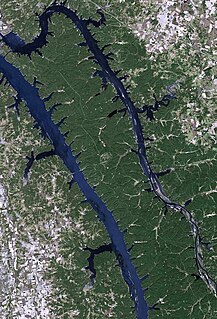
WThe Tuolumne River flows for 149 miles (240 km) through Central California, from the high Sierra Nevada to join the San Joaquin River in the Central Valley. Originating at over 8,000 feet (2,400 m) above sea level in Yosemite National Park, the Tuolumne drains a rugged watershed of 1,958 square miles (5,070 km2), carving a series of canyons through the western slope of the Sierra. While the upper Tuolumne is a fast-flowing mountain stream, the lower river crosses a broad, fertile and extensively cultivated alluvial plain. Like most other central California rivers, the Tuolumne is dammed multiple times for irrigation and the generation of hydroelectricity.
 W
WThe Virgin Islands National Park is an American national park preserving about 60% of the land area of Saint John in the United States Virgin Islands, as well as more than 5,500 acres of adjacent ocean, and nearly all of Hassel Island, just off the Charlotte Amalie, Saint Thomas harbor.
 W
WThe Virginia Coast Reserve is a biosphere reserve created by The Nature Conservancy in the early 1970s. It consists of 40,000 acres across 14 of the Virginia Barrier Islands along the Atlantic coast of the Virginia portion of the Delmarva Peninsula, including Parramore Island, Hog Island, Virginia, Smith Island, Virginia, Assawoman Island, and Metompkin Island. These barrier islands play an important role in sheltering the mainland portions of the Eastern Shore of Virginia from the impact of coastal storms and are important for breeding and migrating beach nesting and colonial waterbirds, including piping plovers. It also serves as the research location for the Virginia Coast Reserve Long-Term Ecological Research (VCR/LTER) project.
 W
WWet Beaver Wilderness is a 6,155-acre wilderness area located in the Coconino National Forest in the U.S. state of Arizona.
 W
WYellowstone National Park is an American national park located in the western United States, largely in the northwest corner of Wyoming and extending into Montana and Idaho. It was established by the U.S. Congress and signed into law by President Ulysses S. Grant on March 1, 1872. Yellowstone was the first national park in the U.S. and is also widely held to be the first national park in the world. The park is known for its wildlife and its many geothermal features, especially Old Faithful geyser, one of its most popular. While it represents many types of biomes, the subalpine forest is the most abundant. It is part of the South Central Rockies forests ecoregion.