 W
WThe Alashan Plateau semi-desert ecoregion covers the south-western portion of the Gobi Desert where precipitation in the mountains is sufficient for a short part of the summer to support sparse plant life. The terrain is basin and range, with elevations from 1,000 to 2,500 metres. The region straddles the China-Mongolian border, with the Tibetan Plateau to the south, and the more arid regions of the Gobi to the north and east.
 W
WThe Altai alpine meadow and tundra ecoregion is a terrestrial ecoregion covering the higher elevation of the Altai Mountains at the center of the "X" formed by the borders separating Russia, Kazakhstan, China, and Mongolia. The mountain peaks are the farthest north in Central Asia, separating the plains of Siberia to the north from the hot, dry deserts to the south. Altitudes above 2,400 meters display characteristics of tundra, with patches of alpine meadows and some trees immediately below the treeline. The ecoregion is in the montane grasslands and shrublands biome, and the Palearctic realm, with a humid continental climate. It covers an area of 90,132 square kilometres (34,800 sq mi).
 W
WThe Altai montane forest and forest steppe ecoregion covers patches of the subalpine forest belt on the Altai Mountains, crossing the border region where Russia, Kazakhstan, Mongolia and China meet. The region has high biodiversity, as it is located in transition zones between different ecoregions, altitudes, and climate zones. It is in the Palearctic realm, with a Cold semi-arid climate. It covers 35,199,998 km2 (13,590,795 sq mi).
 W
WThe Altai steppe and semi-desert ecoregion, as its name indicates, sits in a transition zine between steppe and semi-desert, supporting sparse grass and shrublands. The area is relatively undeveloped, with agriculture mostly represented by grazing livestock. There are a few shallow lakes in depressions used by migratory birds.
 W
WThe Amur meadow steppe ecoregion is spread over two sections of the middle Amur River valley in the Russian Far East. The terrain is one of flat floodplains on alluvial soil. Due to high water table and frequent flooding, the area has remained relatively forest-free, and is today characterized by extensive wetlands of bogs and grasslands. The area remained ice-free during the Pleistocene glaciation, creating a refuge for many plant and animal species. It has an area of 123,283 square kilometres (47,600 sq mi).
 W
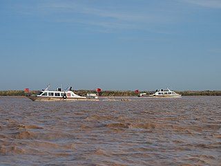
WThe Bohai Sea saline meadow ecoregion covers the coastal deltas of the Yellow River and the Luan River where they enter the Bohai Sea in China. The saline meadows and intertidal mudflats provide an important stopping-over point for birds migrating on the East Asian–Australasian Flyway. The region is under heavy ecological pressure from human development.
 W
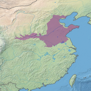
WThe Central China Loess Plateau Mixed Forests ecoregion covers an elongated plateau across north-central China, characterized by accumulated soils of wind-blown dust known as loess and glacial till. The yellowish soil imparts its color to the Yellow River and Yellow Sea downstream. The ecoregion is located west of the lower Yellow River basin and the North China Plain.
 W
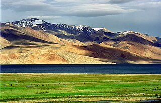
WThe Central Tibetan Plateau alpine steppe ecoregion covers the high alpine plateau that stretches over 1,600 kilometres (1,000 mi) across the Tibetan Plateau to Qinghai Lake in China. Because of the high altitude—much it over 5,000 metres (16,000 ft)—the region is a cold, arid desert that is only 20% covered with steppe and meadow vegetation. The area has been relatively free from human development due to the hostile climate and unsuitability for agriculture. The ecosystem is relatively intact, and supports herds of wild antelope, sheep, deer, and gazelles.
 W
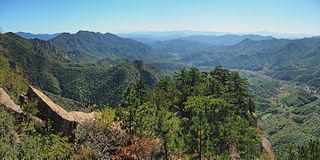
WThe Changbai Mountains mixed forests ecoregion covers the Changbai Mountains and surrounding foothills in China and North Korea. The region features extensive and naturally preserved deciduous and conifer forests. The region exhibits high biodiversity due to its relative isolation, temperate climate with high rainfall, and centrality to central Chinese, Siberian, and European floral communities. In 1979, a significant portion of the ecoregion was designated the Changbaishan Biosphere Reserve by UNESCO.
 W
WThe Changjiang Plain evergreen forests ecoregion covers the plain of the Yangtze River (Changjiang) from where it leaves the mountains at the Three Gorges in the west, to the mouth of the Yangtze at the East China Sea. This plain is one of the most densely populated areas on Earth, and most of the original oak and conifer forests have long been converted to agriculture. Extensive wetlands, however, provide habitat for migratory waterfowl and for diverse aquatic species.
 W
WThe Da Hinggan-Dzhagdy Mountains conifer forests ecoregion covers the Greater Khingan Mountains of northern Manchuria (China), and across the border north into Russia where it follows the mountain ridge for another 500 km to the east. The mountain forests exhibit a floral community called "Daurian flora", a combination of the Siberian taiga to the north and the Manchurian floral types to the south. The eastern slopes are steep and drained by many rivers, the western slopes are gentler, and there are grasslands on some slopes. The ecoregion is in the Palearctic realm, with a Cold semi-arid climate. It covers 35,199,998 km2 (13,590,795 sq mi).
 W
WThe Daba Mountains evergreen forests are a Global 200 endangered ecoregion located on the Daba Mountains in China. The forests are part of temperate broadleaf and mixed forests containing both coniferous and broadleaf trees covering a swath of Central China. Forests here provide a transitional area between evergreen forests to the south and deciduous forests to the north. The Daba Mountains evergreen forests cover areas of northeast Sichuan Province, southern Shaanxi Province, the northern half of Chongqing Municipality, and western Hubei Province.
 W
WThe Daurian forest steppe ecoregion is a band of grassland, shrub terrain, and mixed forests in northeast Mongolia and the region of Siberia, Russia that follows the course of the Onon River and Ulz River. The region has been described as a “sea of grass that forms the best and most intact example of an undisturbed steppe ecosystem and is also one of the last areas in the Palearctic that still supports stable herds of larger vertebrates” in a semi-mountainous area. The area also has flat wetlands that are important to migratory birds. The ecoregion is in the Palearctic realm, with a Cold semi-arid climate. It covers 209,012 km2 (80,700 sq mi).
 W
WDzungaria is a geographical subregion in Northwest China corresponding to the northern half of Xinjiang, also known as Beijiang. Bounded by the Tian Shan mountain range to the south and the Altai Mountains to the north, it covers approximately 777,000 km2 (300,000 sq mi), extending into Western Mongolia and Eastern Kazakhstan. Formerly the term could cover a wider area, conterminous with the Dzungar Khanate, a state led by the Oirats in the 18th century which was based in the area.
 W
WThe Eastern Himalayan alpine shrub and meadows is a montane grasslands and shrublands ecoregion of Bhutan, China, India, Myanmar, and Nepal, which lies between the tree line and snow line in the eastern portion of the Himalaya Range.
 W
WThe Emin Valley is located on the China-Kazakhstan border, in Central Asia. It has an area of about 65,000 square kilometres (25,000 sq mi). Its main waterway is the Emil River.
 W
WThe Gobi Desert is a large desert or brushland region in East Asia. It covers parts of Northern and Northeastern China and of Southern Mongolia. The desert basins of the Gobi are bounded by the Altai Mountains and the grasslands and steppes of Mongolia on the north, by the Taklamakan Desert to the west, by the Hexi Corridor and Tibetan Plateau to the southwest and by the North China Plain to the southeast. The Gobi is notable in history as the location of several important cities along the Silk Road.
 W
WThe Guizhou Plateau broadleaf and mixed forests are a subtropical moist broadleaf forest ecoregion in the Yungui Plateau of China. Much of the original forest has been replaced by secondary forests.
 W
WThe Hainan Island monsoon rain forests ecoregion covers mountainous interior of Hainan Island in China. The tropical forests receive over 1,000 mm/year of rain, heavily concentrated in the summer rainy season. The island has high levels of biodiversity, with over 4,200 plant species, 630 of which are endemic to the island. The region is under ecological pressure from deforestation for agriculture and timber extraction.
 W
WThe Helanshan montane conifer forests ecoregion covers an isolated, forested mountain range surrounded by desert and semi-arid basins. As such, it has been called a "mountain island in the sky", and supports endemic species of plants and animals. The region supports the endangered Helan Shan pika.
 W
WThe Hengduan Mountains subalpine conifer forests are a temperate forest in the Hengduan Mountains of southwestern China. The forests extend within the Jinsha and Yalong River valleys from approximately 32°N to 27°N. In addition, a portion of the Anning River valley and Mianmian Mountains near Lugu Lake support the subalpine conifer forests. This region covers northern Yunnan Province, western Sichuan Province, and the extreme eastern edge of the Tibet Autonomous Region.
 W
WThe Huang He Plain mixed forests ecoregion covers the flat lower ranges of the Yellow River. This area is generally known as the North China Plain. While there is some forest habitat, the region has mostly been converted to agriculture, being one of the most populous areas in the world.
 W
WThe Jiang Nan subtropical evergreen forests ecoregion covers the mountainous divide between the lower Yangtze River and the coastal plain of South China. The region is also a climatic divide between the temperate valleys of the north and the subtropical forests of the south. The region is important for biodiversity and endemic species. The rugged limestone karst hills have been relatively protected from conversion to agriculture, and support specialized plant and animal communities.
 W
WThe Karakoram-West Tibetan Plateau alpine steppe is a montane grasslands and shrublands ecoregion found in parts of Pakistan, China, Afghanistan, and India.
 W
WThe Manchurian mixed forests ecoregion covers the forested hills surrounding the river plains of northern China, Russia, North Korea, and South Korea. The ecoregion supports a number of rare species due to the relative isolation, the diversity of habitat, with mixed forests of deciduous Mongolian oak and conifers of Korean pine. Because mountains rise above the region on three sides, with plains and wetlands below, the area supports high biodiversity as a transition zone.
 W
WThe Mongolian-Manchurian grassland ecoregion, also known as the Mongolian-Manchurian steppe, in the temperate grassland biome, is found in Mongolia, the Chinese Autonomous region of Inner Mongolia and Northeast China.
 W
WThe Nenjiang River grassland ecoregion covers the low wetlands of the lower Nen River in northeast China. The region is known for supporting migratory and permanent nesting populations of a variety of migratory waterfowl, including six species of crane.
 W
WThe North Tibetan Plateau-Kunlun Mountains alpine desert ecoregion covers a long stretch of mostly treeless alpine terrain across the northern edge of the Tibet Plateau. A variety of cold, dry habitats are found, including alpine meadows, steppe, desert, and cushion plant floral areas.
 W
WThe Northeast China Plain deciduous forests ecoregion covers the flat interior Northeast China Plain, in the region historically known as Manchuria. The plain is surrounded by mountains on the north and east, and supports some of China's largest forest tracts. There are also extensive low-lying wetlands, which support important bird populations.
 W
WThe Northeastern Himalayan subalpine conifer forests are a temperate coniferous forests ecoregion of the middle to upper elevations of the eastern Himalayas and southeast Tibetan Plateau. The ecoregion occurs in southeastern Tibet Autonomous Region, China, in northern and eastern Arunachal Pradesh, India, and extreme eastern Bhutan.
 W
WThe Northern Indochina subtropical moist forests are a subtropical moist broadleaf forest ecoregion of northern Indochina, covering portions of Vietnam, Laos, Thailand, Myanmar, and China's Yunnan Province.
 W
WThe Northwestern Himalayan alpine shrub and meadows is a montane grasslands and shrublands ecoregion of the elevations of the northwestern Himalaya of China, India, and Pakistan.
 W
WThe Nujiang Langcang Gorge alpine conifer and mixed forests are a temperate coniferous forests ecoregion in Southwest China and northeastern Myanmar. The forests cover mountains and valleys in the western Hengduan Mountains and because of the extreme topography and relative remoteness, remain one of the best preserved habitats in China.
 W
WThe Pamir alpine desert and tundra ecoregion covers the high plateau of the Pamir Mountains, at the central meeting of the great mountain ranges of Central Asia: Himalaya, Karakoram, Hindu Kush, Kunlun, and Tian Shan. It is a region of relatively high biodiversity due to its central location and high elevation differentials, but it also acts as a barrier between the climate and habitats of north and south Asia.
 W
WThe Qilian Mountains Conifer Forests ecoregion is an ecoregion that consists of a series of isolated conifer forests on the northern slopes of the Qilian Mountain Range, on the northeast edge of the Tibetan Plateau in central China.
 W
WThe Qilian Mountains subalpine meadows ecoregion covers the high meadows and shrubland of the Qilian Mountains, on the northeastern edge of the Tibetan Plateau in central China. These mountains form a divide between the dry regions of the Gobi Desert to the north, and the Qaidam Basin and the Tibetan Plateau to the south. While the habitat supports populations of marmots, grouse and some rare mammal species, the grasslands of the region are under pressure from over-grazing by domestic livestock.
 W
WThe Qin Ling Mountains deciduous forests ecoregion covers the Qin Mountains, which run west-to-east across central China. The mountains effectively divide the biological regions of China into north and south. To the north is the Yellow River basin, a loess-soil region of temperate deciduous forests. To the south is the Yangtze River basic, a subtropical forest region. In between, the Qin Mountains support many rare and endemic species, including the Giant panda and the Sichuan snub-nosed monkey.
 W
WThe Qionglai-Minshan conifer forests are a World Wide Fund for Nature ecoregion in Southwest China. These forests are classified as temperate coniferous forests and are part of the Palearctic realm.
 W
WThe Sichuan Basin evergreen broadleaf forests are a critically endangered WWF ecoregion. The ecoregion occupies the Sichuan Basin in China and covers an area of 9,816,054 ha. The broadleaf forest habitat once covered the Sichuan Basin, but today is limited to mountains and preserved temple grounds in the basin and around the basin's rim. An especially well-preserved example of remaining forest exists on Mount Emei at the western edge of the Sichuan Basin. The original forests are thought to have been made up of subtropical oaks, laurels, and Schima. Much of the remaining Sichuan Basin has been converted to anthropogenic agricultural use in the last 5,000 years.
 W
WThe South China Sea Islands consist of over 250 islands, atolls, cays, shoals, reefs and seamounts in the South China Sea. The islands are mostly low and small, and have few inhabitants. The islands and surrounding seas are subject to overlapping territorial claims by the countries bordering the South China Sea.
 W
WThe South China-Vietnam subtropical evergreen forests ecoregion covers the mountainous coastal region of southeastern China and northeastern Vietnam. The ecoregional also covers the coastal plain along the South China Sea and Hainan Island. The area has significant biodoversity and ecological importance, with high levels of both endemic and threatened species. Rapid urban expansion is reducing biologically-rich forests and wetlands. Ecologically, the suptropical forests are at the northeastern extent of the Indomalayan realm.
 W
WThe South Taiwan monsoon rain forests ecoregion covers the southern tip of Taiwan, 200 km east of the mainland. The area is one of high biodiversity, due to its location between temperate and subtropical zones, its monsoon exposure, and its high altitude variation.
 W
WThe Southeast Tibet shrub and meadows are a montane grassland ecoregion that cover the southeast and eastern parts of the Tibetan Plateau in China. The meadows in this region of Tibet are in the path of the monsoon rains and are wetter than the other upland areas of the Tibetan Plateau. Chinese provinces covered by the Southeast Tibet shrub and meadows include the alpine parts of eastern Tibet Autonomous Region, the alpine parts of western and northern Sichuan, extreme southern and eastern Qinghai, and the montane areas of southern Gansu. Many mountain ranges support the Southeast Tibet meadows, stretching from the Nyainqêntanglha Mountains in the southwest to the Qilian Mountains in the northeast.
 W
WThe Suiphun-Khanka meadows and forest meadows ecoregion is a relatively small ecoregion centered on Lake Khanka, a fresh water lake in the Russian Far East, with a portion in China. The terrain is unforested, flat, and marshy. The area is an important stopover spot for migratory birds, including many vulnerable species. It has an area of 33,929 square kilometres (13,100 sq mi), and is in the Flooded grasslands and savannas biome.
 W
WThe Taklamakan Desert is a desert in Southwest Xinjiang in Northwest China. It is bounded by the Kunlun Mountains to the south, the Pamir Mountains and Tian Shan to the west and north and the Gobi Desert to the east.
WThe Tarim Basin is an endorheic basin in Northwest China occupying an area of about 1,020,000 km2 (390,000 sq mi). Located in China's Xinjiang region, it is sometimes used synonymously to refer to the southern half of the province, or Nanjiang, as opposed to the northern half of the province known as Dzungaria or Beijiang. Its northern boundary is the Tian Shan mountain range and its southern boundary is the Kunlun Mountains on the edge of the Tibetan Plateau. The Taklamakan Desert dominates much of the basin. The historical Uyghur name for the Tarim Basin is Altishahr, which means 'six cities' in Uyghur.
 W
WThe Tarim Basin deciduous forests and steppe is a temperate broadleaf and mixed forests ecoregion in the Xinjiang Uyghur Autonomous Region of western China. The ecoregion includes deciduous riparian forests and steppes sustained by the region's rivers in an otherwise arid region.
 W
WThe Three Parallel Rivers of Yunnan Protected Areas is a UNESCO World Heritage Site in Yunnan province, China. It lies within the drainage basins of the upper reaches of the Yangtze (Jinsha), Lancang (Mekong) and Nujiang (Salween) rivers, in the Yunnan section of the Hengduan Mountains.
 W
WThe Tian Shan foothill arid steppe ecoregion covers the northern and western approaches to the Tian Shan mountains, centered on Lake Issyk-Kul in Kyrgyzstan. This region receives more moisture from Central Asia, thereby supporting more vegetation and diversity of plant and animal species than the deserts to the south.
 W
WThe Tian Shan montane conifer forests ecoregion covers the "forest belt" of the Tian Shan mountains - generally the north-facing slopes that get enough moisture, and are warm enough, for trees to grow. This conifer belt is found mostly between 1,500 and 2,700 meters.
 W
WThe Tian Shan montane steppe and meadows ecoregion covers a 2,000 km long stretch of grasslands of the isolated Tian Sham mountains of Central Asia. It is characterized by high-altitude flat and rolling grasslands.
 W
WThe Tibetan Plateau alpine shrublands and meadows ecoregion covers the middle transition zone between the northern and southern regions of the Tibet Plateau. The region supports both cold alpine steppe and meadows across a broad expanse of the plateau. Wild deer, antelope, and sheep roam the grasslands, but the habitat is increasingly being used to graze domestic livestock.
 W
WThe Western Himalayan alpine shrub and meadows is a montane grasslands and shrublands ecoregion of Nepal, India, and Tibet, which lies between the tree line and snow line in the western portion of the Himalaya Range.
 W
WThe Yarlung Tsangpo arid steppe ecoregion covers the river valley of the Yarlung Tsangpo River on the southern edge of Tibet. The river runs parallel to the northern borders of Nepal, Bhutan and India, between the Himalayas to the south and the Tibet Plateau to the north. The river valleys are the most populated areas of Tibet, putting pressure on wildlife. The area ranges from cold desert in the west to steppe shrub land in the east; the few trees are in the lowest river valleys to the east.
 W
WThe Yellow Sea saline meadow ecoregion covers a thin strip of wetlands between the Shandong Peninsula and the mouth of the Yangtze River on the coast of the East China Sea. The plants of the region are adapted to the wet, saline soils transitioning inland to fresh water arriving from the west. The area is an important stop-over on the East Asian–Australasian Flyway. The region is under heavy ecological pressure from human development and agriculture.
 W
WThe Yunnan Plateau subtropical evergreen forests is an endangered ecoregion in southwestern China. These forests once covered the western parts of the Yungui Plateau but have been significantly reduced and replaced with agricultural land uses. The Yunnan evergreen forests and the neighbouring Guizhou Plateau broadleaf and mixed forests are the only two ecoregions in the Palearctic realm to be classified as part of tropical and subtropical moist broadleaf forests biome.