 W
WThe Californias region, which comprises California and the Baja California Peninsula, includes many coastal islands in the Pacific Ocean. California is in the United States; and the Baja California Peninsula includes the Mexican states of Baja California Sur and Baja California. Although the waters and islands are in two countries, many of the ecoregion, habitat, conservation, and ecological issues are shared.
 W
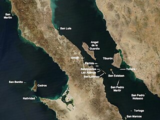
WIsla Ángel de la Guarda, also called Archangel Island, is a large island in the Gulf of California east of Bahía de los Ángeles in northwestern Mexico, separated from the Baja California Peninsula by the Canal de Ballenas. It is the second largest of the eleven Midriff Islands or Islas Grandes. It is part of the state of Baja California, located northwest of Tiburón Island. The island is uninhabited, and is a biological reserve called Isla Angel de la Guarda National Park. The island is part of the Mexicali municipality.
 W
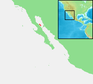
WIsla Ballena, is an island in the Gulf of California east of the Baja California Peninsula. The island is uninhabited and is part of the La Paz Municipality.
WIsla Cabeza de Caballo, or Head of the Horse, is an island in the Gulf of California, located within Bahía de los Ángeles east of the Baja California Peninsula. The island is uninhabited and is part of the Ensenada Municipality. There is a lighthouse located on Isla Cabeza de Caballo along the channel into the harbor of Bahía de los Ángeles.
WIsla Calavera, or the Skull, is an island in the Gulf of California, located within Bahía de los Ángeles east of the Baja California Peninsula. The island is uninhabited and is part of the Ensenada Municipality. It is named skull due to a covering of Guano everywhere except three portions that, from some angles, give the appearance of eye and nose sockets. Sights and sounds from the island contribute to fisherman telling tales of "The Skull". Its northern shore is home to a sea lion colony.
WIsla Cayo, is an island in the Gulf of California east of the Baja California Peninsula. The island is uninhabited and is part of the La Paz Municipality.
WIsla Cerraja, or the Lock, is an island in the Gulf of California, located within Bahía de los Angeles off of the Baja California Peninsula. The island is uninhabited and is part of the Ensenada Municipality.
WIsla Coronado, also known as “Smith Island” on some maps, is just off the eastern shoreline of Mexico's Baja California Peninsula, near Bahía de los Ángeles, in the Gulf of California. The island is approximately 7 kilometers long, and it is dominated by a volcano on its northern end. It is part of the Ensenada Municipality.
WIsla Coronados, is an island in the Gulf of California east of the Baja California Peninsula in Baja California Sur state, Mexico. The island is uninhabited and is part of the Loreto Municipality.
WIsla Danzante, is an island in the Gulf of California east of the Baja California Peninsula. The island is uninhabited and is part of the Loreto Municipality.
WIsla del Carmen is an island of 15,000 hectares, located in the Gulf of California, in Loreto Municipality in the eastern portion of the state of Baja California Sur, Mexico. The island is protected within Loreto Bay National Park which is within the UNESCO "Islands and Protected Areas of the Gulf of California" Mexican World Heritage Site.
WIsla El Coyote is an island in the Gulf of California, located within Bahía Concepción east of the Baja California Peninsula. The island is uninhabited and is part of the Mulegé Municipality.
WIsla El Requeson, is an island in the Gulf of California, located within Bahía Concepción east of the Baja California Peninsula. The island is uninhabited and is part of the Mulegé Municipality.
 W
WIsla Espíritu Santo is an island in the Gulf of California, off the Mexican state of Baja California Sur. It is separated from Isla Partida by a narrow canal.
WIsla Gallina, is an island in the Gulf of California east of the Baja California Peninsula. The island is uninhabited and is part of the La Paz Municipality.
WIsla Gallo, is an island in the Gulf of California east of the Baja California Peninsula. The island is uninhabited and is part of the La Paz Municipality.
WIsla Islitas, is an island in the Gulf of California east of the Baja California Peninsula. The island is uninhabited and is part of the Loreto Municipality.
WIsla La Ventana, or the Window, is an island in the Gulf of California, located within Bahía de los Ángeles east of the Baja California Peninsula. The island is uninhabited and is part of the Ensenada Municipality.
WIsla Lagartija, is an island in the Gulf of California off the Baja California Peninsula. The island is uninhabited and is part of the Mexicali Municipality.
 W
WIsla Las Animas, is an island in the Gulf of California east of the Baja California Peninsula. The island is uninhabited and is part of the La Paz Municipality.
WIsla Mejia is an island in the Gulf of California east of the Baja California Peninsula. The island is uninhabited and is part of the Mexicali Municipality.
WIsla Mitlán, is an island in the Gulf of California, located within Bahía de los Ángeles east of the Baja California Peninsula. It is adjacent to the west coast of Isla Coronado.The island is uninhabited and is part of the Ensenada Municipality.
WIsla Monserrate, is an island in the Gulf of California east of the Baja California Peninsula. The island is uninhabited and is part of the Loreto Municipality.
WIsla Mosca, is an island in the Gulf of California, located within Bahía Concepción east of the Baja California Peninsula. The island is uninhabited and is part of the Mulegé Municipality.
WIsla Pardo, is an island in the Gulf of California east of the Baja California Peninsula. The island is uninhabited and is part of the Loreto Municipality.
 W
WIsla Partida is separated from Isla Espíritu Santo by a shallow, narrow channel. These two islands, in the Gulf of California, are protected by UNESCO as biospheres. They are located a short boat ride from La Paz, which lies on the Baja California Peninsula in Mexico. It has a land area of 15.495 km (9.628 mi) and is part of the Municipality of La Paz in Baja California Sur.
WIsla Pata, the paw or foot, is an island in the Gulf of California, located within Bahía de los Angeles off the coast of the Baja California Peninsula. The island is uninhabited and is part of the Ensenada Municipality.
WIsla Piojo, or Lice Island, is an island in the Gulf of California, located within Bahía de los Ángeles east of the Baja California Peninsula. The island is uninhabited and is part of the Ensenada Municipality.
WIsla Pitahaya is an island in Bahía Concepción near Playa Santispac, in Baja California Sur. The island's name is derived from the fact that the island has many tall pitahaya cacti that are clearly observable from afar. Isla Pitahaya also has a lighthouse. The southwest shore has a small white, sandy beach while the rest of the island is rocky. The island is about 1.5 miles (2.4 km) from Playa Santispac and 0.5 miles (0.80 km) from the nearest mainland shore.
WIsla Pond, is an island in the Gulf of California east of the Baja California Peninsula. The island is uninhabited and is part of the Mexicali Municipality.
WIsla Rasa is an island in the Gulf of California east of the Baja California Peninsula. The island is uninhabited and is part of the Mexicali Municipality. The 0.21 sq./mi island has three small ponds and has small shed located in the center of the island.
WIsla Roca Lobos, is an island in the Gulf of California east of the Baja California Peninsula. The island is uninhabited and is part of the Mexicali Municipality.
WIsla Salsipuedes is an island in the Gulf of California off the coast of the Baja California Peninsula. The island is uninhabited and is part of the Mexicali Municipality.
WIsla San Cosme, is an island in the Gulf of California east of the Baja California Peninsula. The island is uninhabited and is part of the Loreto Municipality.
WIsla San Damian, is an island in the Gulf of California east of the Baja California Peninsula. The island is uninhabited and is part of the Loreto Municipality.
 W
WIsla San Diego is a small island in Mexico in the southern Gulf of California. Administratively it belongs to the municipality of Comondú of the State of Baja California Sur and is very close to the small island called Isla La Habana.
WIsla San Francisco is a small island in Mexico located in the Gulf of California off the eastern coast of Baja California Sur, south of Isla San José. Uninhabited, the island is located in the southern portion of the Gulf of California, north of the Bay of La Paz, some 75 km (47 mi) north of the town of La Paz and is part of the La Paz Municipality. It is separated from the peninsula of Baja California by a channel about 10 km (6.2 mi) wide. The island is 2.5 km (1.6 mi) long and 2.5 km (1.6 mi) wide with maximum total area of 3.78 km2.
WIsla San Ildefonso, is an island in the Gulf of California east of the Baja California Peninsula. The island is uninhabited and is part of the Mulegé Municipality.
WIsla San José is a semi-arid island in the Gulf of California, off the east coast of the Baja California peninsula. Located some 60 km (37 mi) north of the city of La Paz, it belongs politically to the Mexican state of Baja California Sur and is part of the Municipality of La Paz. Its surface area is 182.962 km2, the sixth-largest island in Mexico. The island is also referred to as San José Island in English, though there are other islands by this name.
WIsla San Lorenzo Norte is an island in the Gulf of California east of the Baja California Peninsula. The island is uninhabited and is part of the Mexicali Municipality. The much larger Isla San Lorenzo Sur is located immediately southeast of Isla San Lorenzo Norte.
WIsla San Lorenzo Sur, is an island in the Gulf of California east of the Baja California Peninsula. The island is uninhabited and is part of the Mexicali Municipality. Isla San Lorenzo Norte is located immediately northwest of Isla San Lorenzo Sur.
WIsla San Luis, is an island in the Gulf of California east of the Baja California Peninsula. The island is uninhabited and is part of the Mexicali Municipality.
WIsla Santa Catalina, officially known as Isla Catalana, is an island in the Gulf of California east of the Baja California Peninsula. The island is uninhabited and is part of the Loreto Municipality.
WIsla Santa Cruz, is an island in the Gulf of California, east of the Baja California Peninsula in Baja California Sur state.
WIsla Santa Inés is an island in the Gulf of California east of the Baja California Peninsula. The island is uninhabited and is part of the Mulegé Municipality in the Mexican state of Baja California Sur.
WIsla Santiago, is an island in the Gulf of California, east of the Baja California Peninsula in Baja California Sur state.
WIsla Tijeras, is an island in the Gulf of California east of the Baja California Peninsula. The island is uninhabited and is part of the Loreto Municipality.
WIsla Willard, is an island in the Gulf of California east of the Baja California Peninsula. The island is uninhabited and is part of the Mexicali Municipality.
WIslotes Blancos, is an island in the Gulf of California east of the Baja California Peninsula. The island is uninhabited and is part of the Mexicali Municipality.
WIslotes Las Galeras, are a pair of small islands in the Gulf of California east of the Baja California Peninsula, and just 3/4 miles north of Isla Monserrate. The islands are uninhabited and part of the Loreto Municipality.
 W
WIsla Cerralvo, as is commonly named, whose official name is Isla Jacques Cousteau, is an island located off the Cerralvo Canal coast near La Paz, Baja California Sur, Mexico.
 W
WMontague Island, known in Spanish as Isla Montague, is an island at the mouth of the Colorado River in the municipality of Mexicali, Baja California, Mexico, and is part of the Colorado River Delta and part of a broader region called the Salton Trough. It is about 32 km (20 mi) in length along its longest axis.
 W
WPsorothamnus spinosus, known as the smokethorn, smoketree, smoke tree, smokethorn dalea, and corona de Cristo, is a perennial legume tree of the deserts in North America.
WSan Esteban Island is a small island in the Gulf of California, Mexico, located to the southwest of Tiburón Island. It is part of the Municipality of Hermosillo in Sonora, and has a land area of 39.773 km², the 15th-largest island in Mexico. It is located in the Gulf of California. It was once inhabited by a group of the Seri people.
WSan Pedro Mártir is the name of an island of Mexico, located in the Gulf of California, about halfway between the coast of Baja California and Sonora. San Pedro Mártir is located in the center of the Gulf of California and is the most remote island in the Sea of Cortez. It is located 51 km from Baja California and 53 km off the coast of Sonora. The island is 2 km long and 1.5 km maximum width, with a total of 2,729 km2 of total area. The island is uninhabited by humans and is 60 km from Bahía Kino, the nearest city in the state of Sonora on the west coast.
 W
WSan Pedro Nolasco Island, sometimes called Seal Island, is a small and rugged Mexican island in the Gulf of California. It is 4.2 km long by 1 km wide, and lies 15 km from the nearest point of the Mexican coast and about 28 km west of the resort town of San Carlos on the coast of the Sonoran Desert. The island is protected as a nature reserve and its coastal waters are well known as a sport fishing and diving site.
 W
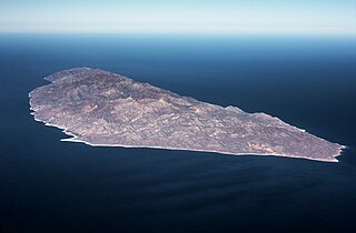
WTiburón Island is the largest island in the Gulf of California and the largest island in Mexico, with an area of 1,201 square kilometres (464 sq mi). It was made a nature reserve in 1963 by President Adolfo López Mateos.
WIsla Tortuga is an island in the Gulf of California, created relatively recently in geologic terms by the volcanism associated with the East Pacific Rise. It lies east-northeast of the city of Santa Rosalía, in Mulegé Municipality. It has a surface area of 11.374 km².