 W
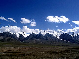
WThe Kunlun Mountains constitute one of the longest mountain chains in Asia, extending for more than 3,000 kilometres (1,900 mi). In the broadest sense, the chain forms the northern edge of the Tibetan Plateau south of the Tarim Basin.
 W
WThe 2001 Kunlun earthquake also known as the 2001 Kokoxili earthquake, occurred on 14 November 2001 at 09:26 UTC, with an epicenter near Kokoxili, close to the border between Qinghai and Xinjiang in a remote mountainous region. With a magnitude of 7.8 Mw it was the most powerful earthquake in China for 5 decades. No casualties were reported, presumably due to the very low population density and the lack of high-rise buildings. This earthquake was associated with the longest surface rupture ever recorded on land, ~450 km.
 W
WHeiqia Pass, Heika Pass or Heiqiazi Daban(Chinese: 黑卡子达坂; lit.: 'black hairpin pass'), also known by Western sources as Kirgizjangal Pass, is a mountain pass along the China National Highway 219 with numerous hairpin turns. The mountain pass connects the Yarkand River valley to the west with the Karakash River valley to the east. Located at 309 kilometres (192 mi) from the northern terminus of the G219 highway, it is between the village of Mazar in Kargilik County and the town of Xaidulla in Hotan County near the boundary of the two counties. The pass is also formally referred to as Kekeate Pass (柯克阿特达坂).
 W
WThe Kunlun or Kunlun Shan is a mountain or mountain range in Chinese mythology, an important symbol representing the axis mundi and divinity.
 W
WThe Kunlun fault is a strike-slip fault to the north side of Tibet. Slippage along the 1,500 kilometres (930 mi) long fault has occurred at a constant rate for the last 40,000 years. This has resulted in a cumulative offset of more than 400 metres (1,300 ft). The fault is seismically active, most recently causing the magnitude 7.8 2001 Kunlun earthquake.
WKunlun Volcanic Group, also known as Ashikule, is a volcanic field in northwestern Tibet. Eight other volcanic fields are also in the area. The field is within a basin that also contains three lakes.
 W
WMazar Pass or Mazar Daban is a long mountain pass with numerous hairpin turns along China National Highway 219 (G219), the highway connecting Xinjiang and Tibet. The mountain pass crosses the Kunlun Mountains. It is between the villages of Kudi and Mazar in Kargilik County in southwestern Xinjiang. Western sources often refer to it as Chiragsaldi Pass. Formal Chinese sources, such academia, also refer to it as Sailyak Pass(Sailiyake Daban; Chinese: 赛力亚克达坂).