 W
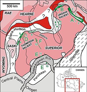
WThe Circum-Superior Belt is a widespread Paleoproterozoic large igneous province in the Canadian Shield of Northern, Western and Eastern Canada. It extends more than 3,400 km (2,100 mi) from northeastern Manitoba through northwestern Ontario, southern Nunavut to northern Quebec. Igneous rocks of the Circum-Superior Belt are mafic-ultramafic in composition, deposited in the Labrador Trough near Ungava Bay, the Cape Smith Belt near the southern shore of Hudson Strait and along the eastern shore of Hudson Bay in its northern portion; the Thompson and Fox River belts in the northwest and the Marquette Range Supergroup in its southern portion. The Circum Superior Belt also hosts a rare example of Proterozoic Komatiite, in the Winnipegosis komatiite belt.
 W
WThe Flin Flon greenstone belt, also referred to as the Flin Flon – Snow Lake greenstone belt, is a Precambrian greenstone belt located in the central area of Manitoba and east-central Saskatchewan, Canada. It lies in the central portion of the Trans-Hudson orogeny and was formed by arc volcanism during the Paleoproterozoic period. The Flin Flon – Snow Lake greenstone belt is 250 km long by 75 km wide and is exposed just north of McClarty Lake. The belt is bounded by metasedimentary gneisses and metavolcanics of the Kisseynew Domain to the north and extends to the south where it is unconformably overlain by Ordovician age dolomite.
 W
WThe Great Bear Magmatic Zone (GBMZ) is a Paleoproterozoic (1.875–1.86 Ga) multi-collisional orogenic belt of which 100 km × 400 km is exposed in the northwestern Canadian Shield east of Great Bear Lake, Northwest Territories.
 W
WThe Jormua Ophiolite is a remnant of ancient oceanic lithosphere near the village of Jormua close to the geographical centre of Finland. The rocks of the Jormua Ophiolite formed about 1,950 million years ago in the Paleoproteozoic Era. The conditions under which the ocean crust rocks of Jormua formed was likely similar to present-day Red Sea. Thus, a linear sea of this type is thought to have existed between two continental landmasses in Finland. At some point this sea closed and the ophiolite was obducted.
WThe Snowbird Tectonic Zone (STZ) is a geological structure in the western Canadian Shield which forms a geophysical boundary between the Hearne Craton and the south-west arm of the Rae Craton. It is enigmatic and has been interpreted as a Proterozoic suture or escape structure, or an Archaean suture reactivated during either the Archaean or Palaeoproterozic. It stretches 2,800 km (1,700 mi) from the Canadian Cordillera north-east to Hudson Bay, diagonally crossing Alberta, Saskatchewan, the Northwest Territories, and Nunavut.
 W
WThe Taltson Magmatic Zone (TMZ) is a north-trending belt of Archean to Paleoproterozoic granitic basement gneiss, amphibolite supracrustal gneissic rock and Paleoproterozoic magmatic rocks in the Canadian Shield, extending from Northern Alberta to the southwestern Northwest Territories. The TMZ basement is 3.2–3.0 Ga and the Rutledge River supracrustal gneisses 2.13–2.09 Ga years old and were intruded by magmatic rocks around 1.99–1.92 Ga.
 W
WThe Winnipegosis komatiite belt is a 150 km (93 mi) long and 30 km (19 mi) wide greenstone belt located in the Lake Winnipegosis area of central Manitoba, Canada. It has no surface exposure and was identified based on geophysical signatures and drilling during mineral exploration by Cominco during the 1990s. The belt has an age of 1870 ± 7 million years and is predominantly composed of basaltic and komatiitic volcanic rocks with minor intrusive and sedimentary rocks. The belt is considered part of the larger Circum-Superior Belt and was likely generated by a mantle plume. The Winnipegosis Komatiite Belt is notable as one of the few examples of komatiite formed during the Proterozoic.