 W
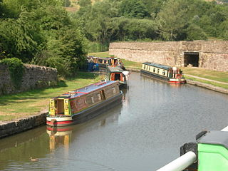
WThe Bugsworth Basin Heritage Trust (BBHT), formerly known as the Inland Waterways Protection Society (IWPS), is a British organisation founded in 1958 to work for the restoration of the canal system. Its members carried out surveys of canals and produced reports in support of their retention when much of the canal network was under threat. Following official support for use of the canals for leisure activities in 1967, the Society have concentrated their efforts on the restoration and operation of Bugsworth Basin, located at the southern end of the Peak Forest Canal, which was one of the first canals that they surveyed in 1958.
 W
WThe Caldon Canal, opened in 1779, runs 18 miles (29 km) from Etruria, in Stoke-on-Trent, to Froghall, Staffordshire. The canal has 17 locks and the 69-metre (226 ft) Froghall Tunnel.
 W
WThe Grantham Canal runs for 33 miles (53 km) from Grantham through 18 locks to West Bridgford, where it joins the River Trent. It was built primarily for the transportation of coal to Grantham. It opened in 1797 and its profitability steadily increased until 1841. It was then sold to a railway company, declined, and was finally closed in 1936. It was used as a water supply for agriculture, and so most of it remained in water after closure, although bridges were lowered. Since the 1970s, the Grantham Canal Society have been working to restore it. Two stretches are now navigable to small vessels. A new route will be required where the canal joins the Trent, as road building has severed the original one.
 W
WThe Hollinwood Branch Canal was a canal near Hollinwood, in Oldham, England. It left the main line of the Ashton Canal at Fairfield Junction immediately above lock 18. It was just over 4.5 miles (7.2 km) long and went through Droylsden and Waterhouses to terminate at Hollinwood Basin. It rose through four locks at Waterhouses (19–22) and another four at Hollinwood (23–26). Immediately above lock 22 at Waterhouses was Fairbottom Junction where the Fairbottom Branch Canal started. Beyond Hollinwood Basin there was a lock free private branch, known as the Werneth Branch Canal, to Old Lane Colliery, which opened in 1797. It is a biological Site of Special Scientific Interest and a Local Nature Reserve.
 W
WThe Manchester Bolton & Bury Canal is a disused canal in Greater Manchester, England, built to link Bolton and Bury with Manchester. The canal, when fully opened, was 15 miles 1 furlong (24.3 km) long. It was accessed via a junction with the River Irwell in Salford. Seventeen locks were required to climb to the summit as it passed through Pendleton, heading northwest to Prestolee before it split northwest to Bolton and northeast to Bury. Between Bolton and Bury the canal was level and required no locks. Six aqueducts were built to allow the canal to cross the rivers Irwell and Tonge and several minor roads.
 W
WThe Schuylkill Canal Association (SCA) is a non-governmental organization that maintains the Oakes Reach and Lock #60 of the Schuylkill Canal as a public recreation area and historical site. Organized in 1982 as the Schuylkill Canal Advisory Board, the Association, in cooperation with Upper Providence Township, Montgomery County, and the Commonwealth of Pennsylvania, maintains the canal reach, associated structures, parks and trails. The area extends along the canal and left bank of the Schuylkill River, from Mont Clare past Port Providence. The area makes up a large part of the Schuylkill Navigation Canal, Oakes Reach Section Historic District (#88000462).
 W
WThe Ulster Canal is a disused canal running through part of County Armagh, County Tyrone and County Fermanagh in Northern Ireland and County Monaghan in the Republic of Ireland. In the early 19th century the idea of linking the lowlands around Lough Neagh with the Erne Basin and the River Shannon system became popular with the more progressive landowners and merchants of Armagh, Monaghan and Fermanagh. The Ulster Canal was built between 1825 and 1842 and was 74 km (46 mi) long with 26 locks. It ran from Charlemont on the River Blackwater to Wattle Bridge on the River Finn, south-east of Upper Lough Erne. It was an ill-considered venture, with the locks built narrower than the other Irish waterways, preventing through trade, and an inadequate water supply. It was an abject failure commercially, and contributed to the collapse of the Lagan Navigation Company, who took it over from the government but were then refused permission to abandon it when they could not afford the maintenance costs. It finally closed in 1931. Waterways Ireland started work on rebuilding the canal at its southern end in 2015.
 W
WThe Waterway Recovery Group (WRG), founded in 1970, is the national co-ordinating body for voluntary labour on the inland waterways of the United Kingdom.