 W
WDoggerland was an area of land, now submerged beneath the southern North Sea, that connected Great Britain to continental Europe. It was flooded by rising sea levels around 6500–6200 BC. Geological surveys have suggested that it stretched from where Great Britain's east coast now is to the present-day Netherlands, western coast of Germany, and peninsula of Jutland. It was probably a rich habitat with human habitation in the Mesolithic period, although rising sea levels gradually reduced it to low-lying islands before its final submergence, possibly following a tsunami caused by the Storegga Slide.
 W
WThe name Eridanos, derived from the ancient Greek Eridanos, was given by geologists to a river that flowed where the Baltic Sea is now. Its river system was better known as the "Baltic River System".
 W
WThe Kupferschiefer or Kupfermergel, is an extensive and remarkable sedimentary unit in Central Europe. The relatively monotonous succession is typically 30 to 60 centimetres and maximum 2 metres (6.6 ft) thick, but extends over an area of 600,000 square kilometres (230,000 sq mi) across the Southern Permian Basin. The Kupferschiefer can be found in outcrop or in the subsurface straddling six countries, including parts of the southern North Sea. The lateral equivalent outcropping in England is called Marl Slate.
 W
WThe Lunde Formation is a geologic formation in Norway. The formation was known to preserve fossils of Plateosaurus sp. in the Norwegian offshore, dating back to the Rhaetian period. The formation comprises dry floodplain; paleosol/pedogenic, concretionary, brown, red, calcareous mudstones.
 W
WThe North Sea basin is located in northern Europe and lies between the United Kingdom, and Norway just north of The Netherlands and can be divided into many sub-basins. The Southern North Sea basin is the largest gas producing basin in the UK continental shelf, with production coming from the lower Permian sandstones which are sealed by the upper Zechstein salt. The evolution of the North Sea basin occurred through multiple stages throughout the geologic timeline. First the creation of the Sub-Cambrian peneplain, followed by the Caledonian Orogeny in the late Silurian and early Devonian. Rift phases occurred in the late Paleozoic and early Mesozoic which allowed the opening of the northeastern Atlantic. Differential uplift occurred in the late Paleogene and Neogene. The geology of the Southern North Sea basin has a complex history of basinal subsidence that had occurred in the Paleozoic, Mesozoic, and Cenozoic. Uplift events occurred which were then followed by crustal extension which allowed rocks to become folded and faulted late in the Paleozoic. Tectonic movements allowed for halokinesis to occur with more uplift in the Mesozoic followed by a major phase of inversion occurred in the Cenozoic affecting many basins in northwestern Europe. The overall saucer-shaped geometry of the southern North Sea Basin indicates that the major faults have not been actively controlling sediment distribution.
 W
WThe North German Basin is a passive-active rift basin located in central and west Europe, lying within the southeasternmost portions of the North Sea and the southwestern Baltic Sea and across terrestrial portions of northern Germany, Netherlands, and Poland. The North German Basin is a sub-basin of the Southern Permian Basin, that accounts for a composite of intra-continental basins composed of Permian to Cenozoic sediments, which have accumulated to thicknesses around 10–12 kilometres (6–7.5 mi). The complex evolution of the basin takes place from the Permian to the Cenozoic, and is largely influenced by multiple stages of rifting, subsidence, and salt tectonic events. The North German Basin also accounts for a significant amount of Western Europe's natural gas resources, including one of the world's largest natural gas reservoir, the Groningen gas field.
 W
WThe Norwegian continental shelf is the continental shelf over which Norway exercises sovereign rights as defined by the United Nations Convention on the Law of the Sea.
 W
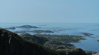
WStrandflat is a landform typical of the Norwegian coast consisting of a flattish erosion surface on the coast and near-coast seabed. In Norway, strandflats provide room for settlements and agriculture, constituting important cultural landscapes. The shallow and protected waters of strandflats are valued fishing grounds that provide sustenance to traditional fishing settlements. Outside Norway proper, strandflats can be found in other high-latitude areas, such as Antarctica, Alaska, the Canadian Arctic, the Russian Far North, Greenland, Svalbard, Sweden and Scotland.