 W
WThe Caspian Sea is the world's largest inland body of water, variously classed as the world's largest lake or a full-fledged sea. As an endorheic basin, it lies between Europe and Asia; east of the Caucasus, west of the broad steppe of Central Asia, south of the fertile plains of Southern Russia in Eastern Europe, and north of the mountainous Iranian Plateau of Western Asia. It covers 371,000 km2 (143,000 sq mi) and a volume of 78,200 km3 (19,000 cu mi). It has a salinity of approximately 1.2%, about a third that of average seawater. It is bounded by Kazakhstan from mid-north to mid-east, Russia from mid-north to mid-west, Azerbaijan to the southwest, Iran to the south and adjacent corners, and Turkmenistan along southern parts of its eastern coast.
 W
WThe Central Asian Internal Drainage Basin or Central Asian Inland Basin is the largest of 3 major hydrological basins that cover Mongolia. It is an endorheic basin.
 W
WThe Iranian Plateau or the Persian Plateau is a geological feature in Central Asia, South Asia, and Western Asia. It is the part of the Eurasian Plate wedged between the Arabian and Indian plates, situated between the Zagros Mountains to the west, the Caspian Sea and the Kopet Dag to the north, the Armenian Highlands and the Caucasus Mountains in the northwest, the Strait of Hormuz and the Persian Gulf to the south and the Indo-Gangetic Plain to the east in Pakistan.
 W
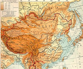
WThe Mongolian Plateau is the part of the Central Asian Plateau lying between 37°46′-53°08′N and 87°40′-122°15′E and having an area of approximately 3,200,000 square kilometres (1,200,000 sq mi). It is bounded by the Greater Hinggan Mountains in the east, the Yin Mountains to the south, the Altai Mountains to the west, and the Sayan and Khentii mountains to the north. The plateau includes the Gobi Desert as well as dry steppe regions. It has an elevation of roughly 1,000 to 1,500 meters, with the lowest point in Hulunbuir and the highest point in Altai.
 W
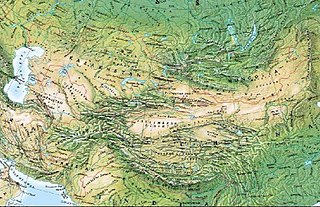
WThe Mountains of Central Asia are a biodiversity hot spot designated by Conservation International which covers several montane and alpine ecoregions of Central Asia, including those of the Pamir and Tian Shan ranges, and extending across portions of Afghanistan, China, Kazakhstan, Kyrgyzstan, Tajikistan, and Uzbekistan.
 W
WThe Pamir Mountains are a mountain range between Central Asia, South Asia, and East Asia, at the junction of the Himalayas with the Tian Shan, Karakoram, Kunlun,and Hindu Kush. They are among the world's highest mountains.
WThe Mountains of Central Asia are a biodiversity hot spot designated by Conservation International which covers several montane and alpine ecoregions of Central Asia, including those of the Pamir and Tian Shan ranges, and extending across portions of Afghanistan, China, Kazakhstan, Kyrgyzstan, Tajikistan, and Uzbekistan.
 W
WThe Tibetan Plateau, also known in China as the Qinghai–Tibet Plateau or the Qing–Zang Plateau or as the Himalayan Plateau in India, is a vast elevated plateau in South Asia, Central Asia and East Asia, covering most of the Tibet Autonomous Region, Northwestern Yunnan, Western half of Sichuan, Southern Gansu and Qinghai provinces in Western China, Indian regions of Ladakh and Lahaul and Spiti as well as Bhutan. It stretches approximately 1,000 kilometres (620 mi) north to south and 2,500 kilometres (1,600 mi) east to west. It is the world's highest and largest plateau, with an area of 2,500,000 square kilometres (970,000 sq mi). With an average elevation exceeding 4,500 metres (14,800 ft) and being surrounded by imposing mountain ranges that harbor the world's two highest summits, Mount Everest and K2, the Tibetan Plateau is often referred to as "the Roof of the World".