 W
WThe Depsang Plains represent a high-altitude gravelly plain at the northwest portion of the disputed Aksai Chin region of Kashmir, divided into Indian and Chinese administered portions across a Line of Actual Control. India controls the western portion of the plains as part of Ladakh, whereas the eastern portion is controlled by China and claimed by India. The Depsang plains are also part of the area called Sub-Sector North (SSN) by the Indian military.
 W
WHaldi Cones are a group of mountains located in Karakoram range in Ghanche district of Gilgit Baltistan. The granite peaks are located in Haldi village located at a distance of 25 km from Khaplu town. Most of these towers and cones are not climbed yet. While the peaks of Khane Valley located in the north of Haldi cones were climbed.
 W
WThe Pir Panjal Range, also Panchaladeva in Hindu scriptures, is a group of mountains in the Lesser Himalayan region, running from east-southeast (ESE) to west-northwest (WNW) across the Indian state of Himachal Pradesh, the Indian administrated Union Territory of Jammu and Kashmir and the Pakistani administered territory of Azad Kashmir, where the average elevation varies from 1,400 m (4,600 ft) to 4,100 m (13,500 ft). The Himalayas show a gradual elevation towards the Dhauladhar and Pir Panjal ranges. Pir Panjal is the largest range of the Lesser Himalayas. Near the bank of the Sutlej River, it dissociates itself from the Himalayas and forms a divide between the Beas and Ravi rivers on one side and the Chenab on the other. The renowned Galyat mountains are also located in this range. The region is connected to the Valley of Kashmir via Mughal Road and used to be the historical connction of Kashmir with India.
 W
WThe Rimo Muztagh is one of the most remote subranges of the Karakoram range. The southern part of Rimo Muztagh is in the Ladakh portion of far northwestern India, also claimed by Pakistan. The northern half, including the Rimo massif, is in the Siachen area. It is far from major towns, and close to the militarily sensitive Siachen Glacier, so it has seen little exploration or climbing activity compared to, for example, the nearby Baltoro Muztagh. The highest peak is Mamostong Kangri, 7,516 metres.
 W
WThe Saltoro Mountains are a subrange of the Karakoram Range. They are located in the southeast Karakoram on the southwest side of the Siachen Glacier, one of the two longest glaciers outside the polar regions. The name given to this range is shared with the Saltoro Valley which is located to the west of this range, downslope on the Pakistan side of the Saltoro Range which generally follows the Actual Ground Position Line. Saltoro Kangri peak, Saltoro River, and Saltoro Valley are features on this range. Actual Ground Position Line (AGPL) between India held and Pakistan held area runs through this range where higher peaks and passes of disputed Siachen area are held by India and Pakistan occupies the lower peaks and valleys.
 W
WThe Saser Muztagh is the easternmost subrange of the Karakoram range, in the Ladakh region of India. It is bounded on the south, east and northeast by the Shyok River, which bends sharply around the southeast corner of the range. On the west it is separated from the neighboring Kailas Mountains by the Nubra River, while the Sasser Pass marks the boundary between this range and the Rimo Muztagh to the north. The Ladakh Range stands to the south of the Saser Muztagh, across the Shyok River.
 W
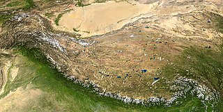
WThe Tibetan Plateau, also known in China as the Qinghai–Tibet Plateau or the Qing–Zang Plateau or as the Himalayan Plateau in India, is a vast elevated plateau in South Asia, Central Asia and East Asia, covering most of the Tibet Autonomous Region, Northwestern Yunnan, Western half of Sichuan, Southern Gansu and Qinghai provinces in Western China, Indian regions of Ladakh and Lahaul and Spiti as well as Bhutan. It stretches approximately 1,000 kilometres (620 mi) north to south and 2,500 kilometres (1,600 mi) east to west. It is the world's highest and largest plateau, with an area of 2,500,000 square kilometres (970,000 sq mi). With an average elevation exceeding 4,500 metres (14,800 ft) and being surrounded by imposing mountain ranges that harbor the world's two highest summits, Mount Everest and K2, the Tibetan Plateau is often referred to as "the Roof of the World".
 W
WThe Zabarwan Range is a short sub-mountain range between Pir Panjal and Great Himalayan Range in the central part of the Kashmir Valley in the Union Territory of Jammu and Kashmir in India.