 W
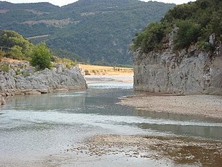
WThe Achelous, also Acheloos, is a river in western Greece. It is 220 km (137 mi) long. It formed the boundary between Acarnania and Aetolia of antiquity. It empties into the Ionian Sea. In ancient times its spirit was venerated as the river god Achelous.
 W
WAntichasia is a forested mountain range in the northern Trikala and Larissa regional units in Thessaly, Greece. The range is part of the eastern foothills of the Pindus mountains. Its highest point is 1,424 m elevation, in the eastern part of the mountains. The Meteora rocks near Kalampaka are considered part of Antichasia. Antichasia stretches from the valley of the river Mourgkani in the west to the valley of the river Titarisios in the east. Both are tributaries of the river Pineios, which flows southwest and south of the mountains. Its length is approximately 45 km from east to west. The nearest mountains ranges are Chasia to the northwest and Kamvounia to the northeast. The vast Thessalian Plain is to the south.
 W
WAthamanika or Tzoumerka is a mountain range in northwestern Greece, part of the wider Pindus mountain range. Its highest point is the mountain Kakarditsa, at 2,429 m. Its length is approximately 40 km from north to south and its width is approximately 15 to 20 km from east to west. The only major road crossing the Athamanika is the Greek National Road 30.
WChasia is a forested mountain range in the northern Trikala (Thessaly) and the southern Grevena regional units, northern Greece. It is an eastern extension of the Pindus mountain range. The elevation of its highest peak, Kratsovo, is 1,564 m (5,131 ft). It stretches from the village Korydallos in the west to Kerasoula in the east, over a length of about 35 km (22 mi). The nearest mountains are the Antichasia to the south, the Kamvounia to the northeast and the Lygkos to the west. It is drained by tributaries of the Aliakmonas to the north, and by the Pineios and its tributary Mourgkani to the south.
 W
WThe Enipeas or Enipeus is a river in central Greece, tributary of the Pineios near Farkadona. It is 84 km (52 mi) long. Its source is in the northern part of Phthiotis, on the plateau of Domokos. Its course runs through several of the tetrades of ancient Thessaly, from Achaea Phthiotis in South through Phthia to finally flow into the Pineios in Histiaeotis.
 W
WLakmos is a mountain in eastern Ioannina and western Trikala regional units. The mountain is a part of the Pindus mountain range. Its highest peak is the Peristeri, at 2,295 m elevation. It stretches from the village Krapsi in the west to near Metsovo in the east, over a length of about 20 km (12 mi). The nearest mountains are the Athamanika to the south, the Lygkos to the north and the Mitsikeli to the west. It is drained by the river Arachthos and its tributaries to the north, west and south, and by the Acheloos to the east.
 W
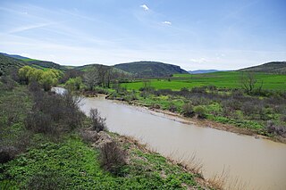
WThe Pineios is a river in Thessaly, Greece. The river is named after the god Peneus. During the later Middle Ages, it was also known as the Salamvrias or Salavrias (Σαλα[μ]βριάς).
WThe Zarkos is a small mountain range in central Thessaly in Greece. It is situated on the border of the Larissa and the Trikala regional unit. Its highest point is 734 m. It is 15 km long and 12 km wide and covers and area of 100 to 150 km². Grasslands are in the lower elevations and forests in the higher elevations. It is drained by the river Titarisios to the north and the Pineios to the south.