 W
WThe Depsang Plains represent a high-altitude gravelly plain at the northwest portion of the disputed Aksai Chin region of Kashmir, divided into Indian and Chinese administered portions across a Line of Actual Control. India controls the western portion of the plains as part of Ladakh, whereas the eastern portion is controlled by China and claimed by India. The Depsang plains are also part of the area called Sub-Sector North (SSN) by the Indian military.
 W
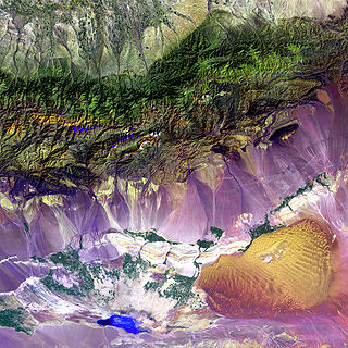
WThe Flaming Mountains or Gaochang Mountains, are barren, eroded, red sandstone hills in the Tian Shan of Xinjiang. They lie near the northern rim of the Taklamakan Desert and east of the city of Turpan. Their striking gullies and trenches caused by erosion of the red sandstone bedrock give the mountains a flaming appearance at certain times of the day.
 W
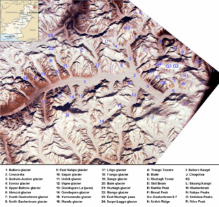
WThe 'Sarpo Laggo Glacier is a glacier in the autonomous region Xinjiang of China, in the Karakoram mountain range of the Himalayas. It lies north of the Baltoro Muztagh range. It could be reached from the Baltoro glacier on the Pakistani side of the Karakorams via the Old Muztagh Pass northeast of the Trango Towers. It is however easier to approach the glacier from the Chinese side, starting a long hike at Kashgar on the Karakoram Highway and finally passing K2's northern base camp. The Glacier is named after Francis Younghusband, who was the first person to pass the Old Mustagh Pass and thus enter the Sarpo Laggo region. There is another glacier not far away, also named after him: Younghusband glacier flows from Muztagh Tower towards the Baltoro Glacier.
 W
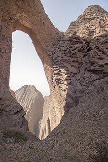
WShipton's Arch (Uyghur: تۆشۈك تاغ, ULY: Töshük tagh, UYY: Tɵxük taƣ, USY: Төшүк тағ , literally "Hole Mountain"; simplified Chinese: 阿图什天门; traditional Chinese: 阿圖什天門; pinyin: Ātúshí tiānmén; Wade–Giles: A1t'u2shih2 t'ien1men2; lit.: 'Artux Heavenly Gate' or simply simplified Chinese: 天门; traditional Chinese: 天門; pinyin: Tiānmén; Wade–Giles: T'ien1men2; lit.: 'Heavenly Gate') is a conglomerate natural arch in China's Xinjiang Uyghur Autonomous Region. It is located in Kizilsu Kirghiz Autonomous Prefecture west-northwest of Kashgar, near the village of Artux, at an altitude of 2,973 metres (9,754 ft).
 W
WThe Tarim Basin is an endorheic basin in Northwest China occupying an area of about 1,020,000 km2 (390,000 sq mi). Located in China's Xinjiang region, it is sometimes used synonymously to refer to the southern half of the province, or Nanjiang, as opposed to the northern half of the province known as Dzungaria or Beijiang. Its northern boundary is the Tian Shan mountain range and its southern boundary is the Kunlun Mountains on the edge of the Tibetan Plateau. The Taklamakan Desert dominates much of the basin. The historical Uyghur name for the Tarim Basin is Altishahr, which means 'six cities' in Uyghur.
 W
WThe Tianshan Volcanic Group is a volcanic field in the Tianshan Mountains in Northwest China. The historically active Cone of Pechan is within the group. The volcano is 440 km southwest of Urumqi, Xinjiang.
 W
WThe Turfan volcano is a volcano near the city of Turpan, Xinjiang. It lies within the Flaming Mountains
 W
WThe Turpan Depression or Turfan Depression, is a fault-bounded trough located around and south of the city-oasis of Turpan, in the Xinjiang Autonomous Region in far Western China, about 150 kilometres (93 mi) southeast of the regional capital Ürümqi. It includes Lake Ayding, −154 metres (−505 ft), the second or third lowest depression on Earth. By some measures, it is also the hottest and driest area in China during the summer.