 W
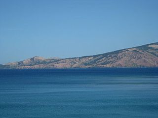
WLake Pinatubo is the summit crater lake of Mount Pinatubo formed after its climactic eruption on June 15, 1991. The lake is located in Botolan, Zambales, near the boundaries of Pampanga and Tarlac provinces in the Philippines. It is about 90 km (56 mi) northwest of the capital city of Manila. While one paper by researchers from Japan suggested a depth of 600 m (2,000 ft), more detailed research suggests that 95–115 m (312–377 ft) is more accurate.
 W
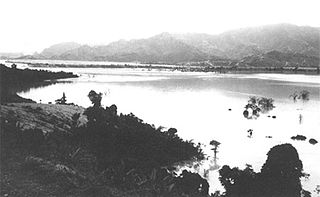
WMapanuepe Lake is a freshwater lake located in the province of Zambales in the Philippines. The lake was created after the cataclysmic eruption of Mount Pinatubo in 1991. Lahars following the eruption blocked the drainage of Mapanuepe River, south of the volcano, flooding Mapanuepe Valley together with its settlements. Only the steeple of the church protruding out of the water remained on one of the villages.
 W
WMount Tapulao is the tallest mountain in the Zambales Mountain range and in the province of Zambales in the Philippines. The peak, which rise to an elevation of 2,037 metres (6,683 ft), is located in the municipality of Palauig, Zambales. Its name is derived from the abundance of Sumatran Pine trees in the area, known in Zambal as tapolaw.
 W
WMount Pinatubo is an active stratovolcano in the Zambales Mountains, located on the tripoint boundary of the Philippine provinces of Zambales, Tarlac and Pampanga, all in Central Luzon on the northern island of Luzon. Its eruptive history was unknown to most before the pre-eruption volcanic activities of 1991, just before June. Pinatubo was heavily eroded, inconspicuous and obscured from view. It was covered with dense forests which supported a population of several thousand indigenous Aetas.
 W
WThe Redondo Peninsula is a short mountainous peninsula extending about 15 kilometers to the south of Zambales on western Luzon in the Philippines. It separates Subic Bay and the coasts around the Subic Bay Metropolitan Area of Subic and Olongapo from the South China Sea. It is known for its secluded coves, beaches and pine-forested mountains.
 W
WScarborough Shoal, also known as Bajo de Masinloc (Spanish), Panatag Shoal, Huangyan Island and Democracy Reef, are two rocks in a shoal located between the Macclesfield Bank and Luzon island in the South China Sea. The nearest land mass from it is Luzon, the largest island in the Philippines.
 W
WSubic Bay is a bay on the west coast of the island of Luzon in the Philippines, about 100 kilometres (62 mi) northwest of Manila Bay. An extension of the South China Sea, its shores were formerly the site of a major United States Navy facility, U.S. Naval Base Subic Bay, now an industrial and commercial area known as the Subic Bay Freeport Zone under the Subic Bay Metropolitan Authority.
 W
WThe Zambales Mountains is a mountain range on western Luzon island in the Philippines. The mountains separate Luzon's central plain from the South China Sea. Its most prominent section is known as the Cabusilan Mountain Range composed of Mt. Pinatubo, Mount Negron and Mount Cuadrado, which are believed to be remnants of the ancestral Pinatubo peak. The highest elevation in the Zambales Mountains is Mount Tapulao, also known as High Peak, in Zambales province which rises to 2,037 metres (6,683 ft).