 W
WMount Diatuto is a mountain in East Timor, a country occupying the eastern end of the island of Timor in the Lesser Sunda Islands of Wallacea.
WFatumasin is a mountain in the district of Liquiçá in East Timor, a country occupying the eastern end of the island of Timor in the Lesser Sunda Islands of Wallacea. The surrounding forest is called Hutan Gunung Maelulu in Indonesian. It is a 13,618 ha mountain forest and forms one of the country's Important Bird Areas.
 W
WManucoco, also referred to as Gunung Manucoco or Mount Manucoco, is a mountain in the Atauro Island subdistrict of the Dili District of East Timor. It stands near the southern end of Atauro Island, at the western end of Wetar Strait, some 25 km (16 mi) north of Dili, the nation's capital. The rugged topography of the island's highlands is a result of the erosion of uplifted, originally submarine, volcanoes from the Neogene period creating narrow, dissected ridges and steep slopes, with Manucoco forming the highest point. The upper levels of the mountain still carry patches of tropical semi-evergreen mountain forest in sheltered valleys, covering about 40 km2 (15 sq mi). The mountain, along with the whole of Atauro Island, has been identified as an Important Bird Area by BirdLife International because it supports populations of several of Timor’s and Wetar's restricted-range native bird species.
 W
WMatebian or Matebean is the third highest mountain in Timor Leste, after Ramelau (Tatamailau).
 W
WMount Curi is a mountain in Manatuto District, East Timor. It is part of the Mount Curi Important Bird Area and has an elevation of 1,332 m.
 W
WPaitchau is a mountain in the Tutuala subdistrict, Lautém District of East Timor. Situated within Nino Konis Santana National Park, it is south of Lake Ira Lalaro. Though part of a mountain chain, Paitchau is an isolated mountain in the southern Sucos Mehara. It ranges in altitude from 0–960 metres (0–3,150 ft). BirdLife International has classified the mountain and its surrounding region of 55,797 hectares as an Important Bird Area of East Timor. The area contained within the Paitchau Range and Ira Lalaro is sparsely populated and contains several unique faunal and floral species.
 W
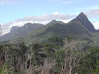
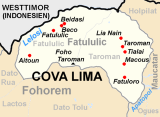
WTaroman is the highest mountain in the Cova Lima district of East Timor.
 W
WTatamailau, or Tata Mailau, sometimes referred as Mount Ramelau, is the highest mountain in East Timor and also of Timor island at 2,986 m (9,797 ft). The mountain is located approximately 70 km (43 mi) south of the capital Dili in the district of Ainaro. While East Timor was a Portuguese colony it was called the highest mountain of Portugal in the twentieth century, since the highest mountain of Portugal proper is of a more modest height. The name "Tatamailau" is Mambai-origin, the local language and means "Grandfather of all". "Ramelau" is the name of the massif of the mountain. The Tatamailau is dedicated to the Virgin Mary and the subject of an annual pilgrimage commemorating the Annunciation of the Blessed Virgin Mary, on or around 25 March. There is a three-metre-high statue of the Virgin Mary on the peak, which came from Italy and was erected during Indonesian occupation in 1997.